
Pickett's Charge - High-Water Mark of the Confederacy.

The Battle of Gettysburg.
sold
- Digital Map Information
- Suitable for large format printing
- File Size: 44.7 MB
- File Type: ZIP / TIFF
- ICC color profile embedded
- Delivered instantly via download link
This is a stunning 1884 Kurz and Allison chromolithograph view of the Battle of Gettysburg, specifically Pickett's Charge - an event considered to be the turning point of the American Civil War (1861 - 1865). (more details)
Only known example of 1867 lithograph of Balling's famous mural.

Heroes of the Republic.
sold
- Digital Map Information
- Suitable for large format printing
- File Size: 118.3 MB
- File Type: ZIP / TIFF
- ICC color profile embedded
- Delivered instantly via download link
The only known surviving example of a rare 1867 Civil War view illustrating the 'Heroes of the Republic'. The view is based on a mural by Hansen 'Ole Peter' Balling, presented in 1865, just as the war ended. It is centered on General Ulysses S. Grant (1822 - 1885), with General William Tecumseh Sherman (1869 - 1883) on his left. The duo are surrounded by an additional 25 generals, all mounted. The banners of the Union are being held aloft. We note that the generals look remarkably calm and composed considering that they are charging their warhorses over rough terrain. (more details)
Ephemeral New England transport network.
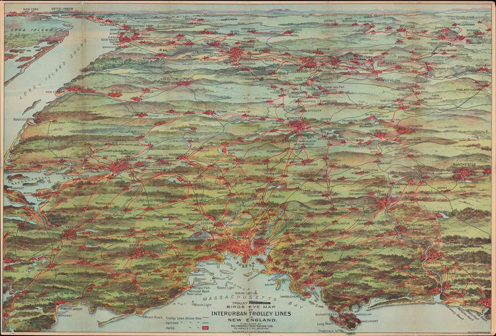
Trolley Pathfinder Birds Eye Map of Interurban Trolley Lines in New England.
sold
- Digital Map Information
- Suitable for large format printing
- File Size: 28.35 MB
- File Type: ZIP / TIFF
- ICC color profile embedded
- Delivered instantly via download link
This is a vivid 1905 chromolithograph bird's-eye view style pocket map of New England by George Walker issued for the Metropolitan News Company. The view was issued to promote the extensive but ephemeral New England streetcar network. Centered on Boston and oriented with north to the right, the map reveals New England from Portsmouth to New York City and Long Island, excluding Cape Cod. It features the extensive trolley lines connecting the major New England cities including Boston, Providence, Brockton, Plymouth, Manchester, Springfield, Portsmouth, Worchester, Hartford and others. It also notes railway lines, parks, lakes, rivers and other geographic features. (more details)
Railroads leading west.

ABC The Pathfinder Railway Guide Map. Western Section.
sold
- Digital Map Information
- Suitable for large format printing
- File Size: 146.23 MB
- File Type: ZIP / TIFF
- ICC color profile embedded
- Delivered instantly via download link
An engaging 1902 railroad map of the western part of the United States by the New England Railways Publishing Company. The map depicts the United States from the Pacific Ocean to New York and Florida, and from southern Canada to Mexico. The railroad network throughout the western 4/5ths of the United States is here laid out in staggering detail. Lakes, rivers, and mountain ranges are included. Five inset maps situated in the lower left illustrate Alaska, Yellowstone National Park, the Philippines, Guam, and the Hawaiian Islands. (more details)
Florida's many natural and man made tourist attractions.

Ken Friedman's Cartoon Map of Florida.
sold
- Digital Map Information
- Suitable for large format printing
- Full resolution TIFF file
- ICC color profile embedded
- Delivered instantly via download link
This is a 1938 Kenneth A. Friedman pictorial map of Florida. The map encapsulates the comedic tone of Friedman's guidebook, Kenneth A. Friedman's Cartoon Guide of Florida. Tourist sites, national parks, monuments, colleges, and Florida's many cities populate the map. Sketches of Florida wildlife, including a 'Florida Wild Cat', a black bear, and a sea cow (manatee) make appearances. Everglades National Park, which was then being created, is labeled, along with Big Cypress Swamp and Lake Okeechobee. Historical sites across the state, such as Fort Matanzas, the Ringling Museum, and Fort Jefferson on Dry Tortugas, line the coast. A gigantic school of fish (all labeled) swim from Jacksonville to Pensacola. Among these are all the Florida angling classics: barracuda, tarpon, sailfish, and marlin. Two green sea turtles make an appearance just below the title cartouche. (more details)
First official large format plan of Washington D.C.
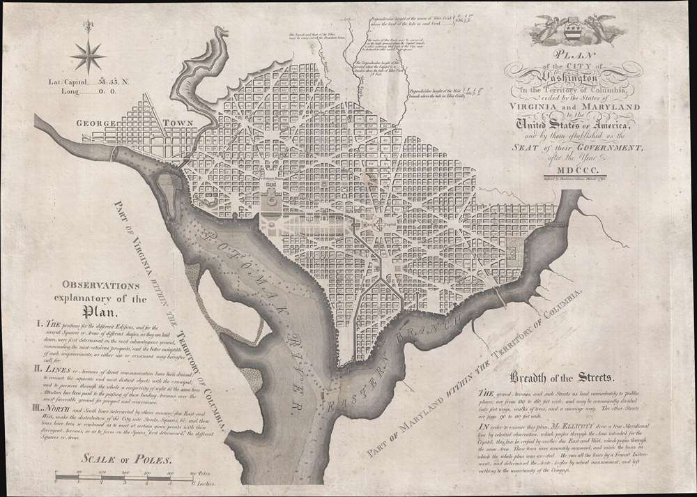
Plan of the City of Washington in the Territory of Columbia, ceded by the States of Virginia and Maryland to the United States of America, and by them established as the Seat of their Government, after the year MDCCC.
sold
- Digital Map Information
- Suitable for large format printing
- Full resolution TIFF file
- ICC color profile embedded
- Delivered instantly via download link
This is Andrew Ellicott's seminal 1792 official large format plan or map of Washington D.C., which would become, 8 years later, the capital of the United States. This is the grandest, most beautiful, and most important official founding plan of Washington D.C. The map illustrates the original urban layout of Washington D.C, then only a small part of the District of Colombia. Centered on the confluence of the Potomac and the Eastern Branch (Anacostia) Rivers, the map covers the Washington D.C. grid as far north as W Street. It also includes the older nearby city of Georgetown. (more details)
Washington Square Park!

Map of the Haring or Herring Farm, showing its Original Perimeter as surveyed in 1784 by David Haring with the Streets and Avenues accurately laid down, also the Division of the Farm by Partition and c.
sold
- Digital Map Information
- Suitable for large format printing
- File Size: 29.8 MB
- File Type: ZIP / TIFF
- ICC color profile embedded
- Delivered instantly via download link
This is John Bute Holmes's rare January 1869 cadastral map of Greenwich Village, or more properly the West Village, New York City. Like Holmes' rarest and most desirable work, this is one of the earliest, if not the earliest, specific published maps of the West Village, including the area around and immediately to the south of Washington Square Park. Reference tables in the lower right and left corners reference deeds and other property documents on file with the city Clerk's office. (more details)
Dominant 16th century mapping of Paris.

Lutetia vulgari Nomine Paris, Urbs Galliae Maxima, Sequana Navigabili Flumine Irrigatur...
sold
- Digital Map Information
- Suitable for large format printing
- Full resolution TIFF file
- ICC color profile embedded
- Delivered instantly via download link
A handsome example of the Braun and Hogenberg's 1572 map and view of Paris, France. With the Seine flowing at center around the Île de la Cité, this view looks on Paris from the northwest, with the top oriented to the southeast. The city is presented from an equidistant bird's-eye perspective wherein all structures are rendered in view form, but from a uniform height and angle relative to all individual points. Fertile fields surround the city, and the river bustles with boats, suggesting richness and prosperity. In the bottom left corner, a man greets two women, all wearing clothing corresponding to the Spanish-influenced fashion norms of 1560 - 1570. The Bastille, a prison infamous even prior to the French Revolution, appears here at top center, surrounded by a moat. The 1550 bastion, appearing to the left of the main structure of the Bastille is also evident. The map's title 'Lutetia,' is the Latin name for Paris which, by the 16th century, had largely been phased out but still appeared in academic references. (more details)
Enormous rare nautical chart detailing south Florida.
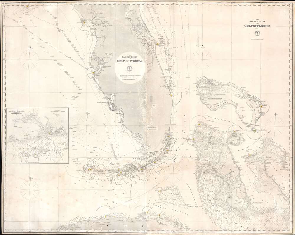
The Bahama Banks and Gulf of Florida, Sheet 1.
sold
- Digital Map Information
- Suitable for large format printing
- File Size: 102.17 MB
- File Type: ZIP / TIFF
- ICC color profile embedded
- Delivered instantly via download link
A most uncommon 1873 U.S. Navy Hydrographic Office nautical chart or maritime map of Florida and the Bahamas. Coverage embraces the lower two-thirds of peninsular Florida, the Florida Strait as far as Cuba, and the northern Bahamas. An inset in the lower left details Key West and it's vicinity from the 1851 U.S. Cost Survey of J. R. Rodgers. The Bahamas are superbly detailed with thousands of soundings - underscoring the danger of navigating these shallow waters. This chart follows in the lineage of Edmund March Blunt's great chart of 1844 - and is indicative of that commercial cartographer's long-standing influence on official naval chart making. (more details)
Striking map capturing the sprit of the mid-19th century.
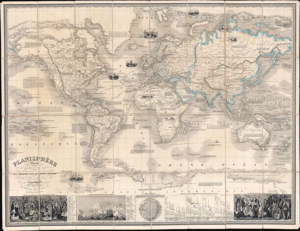
Planisphère Illustré présentant la description géographique des parties connues de la Terre indiquant l'époque des grandes decouvertes et le nom des navigateurs, les Coloniess des Diverses Nations ainsi que le percours des bateaux à vapeur, l'époque des départs, la durée du trajet, et c.
sold
- Digital Map Information
- Suitable for large format printing
- Full resolution TIFF file
- ICC color profile embedded
- Delivered instantly via download link
A striking 1850 Alexandre Vuillemin map of the world, here in its first edition, capturing the social, economic, and scientific ethos of the mid-19th century. Centered on the Bight of Benin, Vuillemin's dissected folding map covers the entire world on a Mercator Projection. The map's magnificent size allows for stupendous detail throughout and accommodates copious annotations, some of which are fascinating. Nine large vignettes illustrate dramatic scenes ranging from whaling in the Arctic and Antarctic, to jousting at ostriches in Africa. Major maritime routes are illustrated, with distances. Also, in the Arctic and Antarctic, ice flows are illustrated pictorially to high dramatic effect. Some annotations of exceptional interest including a note on the California Gold Rush (still of great interest in 1850), the cod fisheries on the Grand Banks, and the discovery of Lyakhov's ivory islands (New Siberia). In the lower quadrants statistical charts illustrate comparative mountain heights and river lengths. To either side, ethnographic charts illustrate the traditional dress of diverse peoples. (more details)
Culmination of nearly 100 years of survey work in these waters.
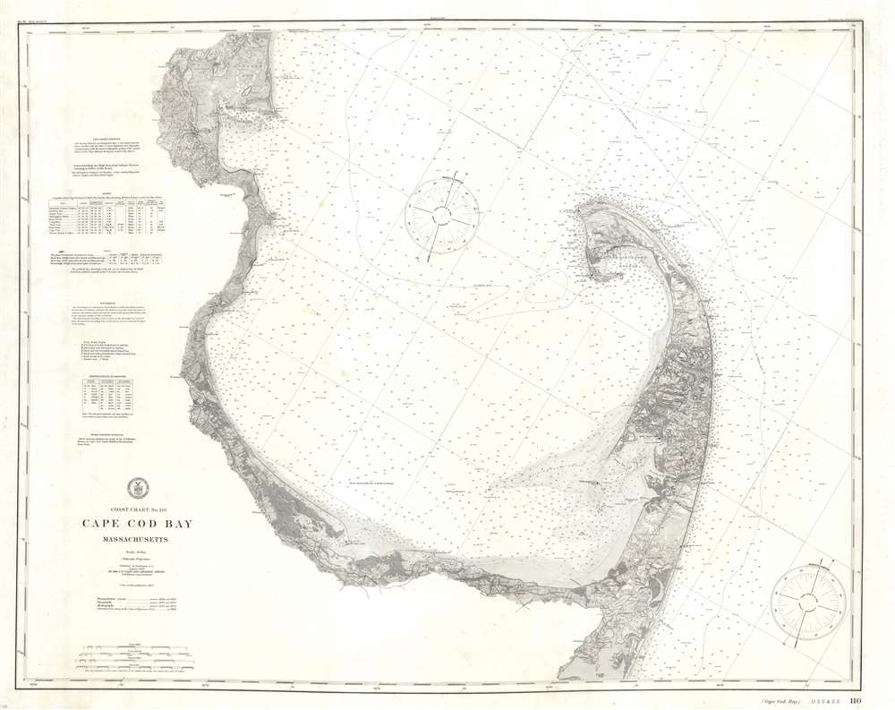
Coast Chart No. 110 Cape Cod Bay Massachusetts.
sold
- Digital Map Information
- Suitable for large format printing
- File Size: 41.42 MB
- File Type: ZIP / TIFF
- ICC color profile embedded
- Delivered instantly via download link
A stunning large format separate issue 1908 U.S. Coast Survey nautical chart or maritime map of Cape Cod Bay - representing the culmination of nearly 100 years of active survey work in these waters. The chart follows the Massachusetts coastline from Duxbury Bay to Provincetown at the tip of Cape Cod and south as far as Nickerson's Neck. As a whole it is extraordinarily engraved, with near 3-dimensional detail inland on the Cape. At the base of the map there are three land profile charts - intended to help navigators identify prominent features on distant shorelines. The left-hand quadrants of the map feature various tables, sailing instructions, notes on soundings and tides, and a wealth of other practical information for the mariner. (more details)
Famous British Empire pictorial map.

The Commonwealth of Nations - or the British Empire.
sold
- Digital Map Information
- Suitable for large format printing
- Full resolution TIFF file
- ICC color profile embedded
- Delivered instantly via download link
This is a stunning 1937 pictorial map of the world highlighting the British Empire. The map was drawn by Alonzo C. Webb to celebrate King George VI's May 1937 coronation and published in a special color section of the Christian Science Monitor. It depicts the whole world on a Mercator Projection, with British territories, or the Commonwealth, highlighted in red. The whole is surrounded by elaborately gilded heraldic designs. Quotes from Milton and Emerson lionizing British achievement appear along the bottom border. The magnificent blue and red ink and the gilt work truly makes this an eye-catching piece. (more details)
Enthusiasm for Space Exploration - blending fact and fantasy.

Interplanetary Space Guide.
sold
This is a 1958 Western Printing and Lithographing map of the Solar System. With the Sun at the bottom of the sheet in the 'foreground', the nine planets are illustrated in orbital order from Mercury through Pluto. Each planet is labeled and each one's diameter, orbit around the Sun (given in Earth years), and number of moons (as of 1959) are provided. Artistic renderings of the surface of Venus, Mercury, the Moon, and Mars line the top of the sheet. Illustrations explaining solar and lunar eclipses as well as some general information about the universe appear along the top border as well. Sketches of the twelve zodiac constellations occupy the lower left and right sides. Illustrations of two real satellites, Explorer III and Sputnik III are situated along the bottom superimposed over the illustration of the Sun. These are flanked by illustrations of a rocket and a capsule-like 'space suit', both of which feel as if they have been lifted directly from the pages of a Arthur C. Clarke novel. (more details)
Unusual advertising ephemera.
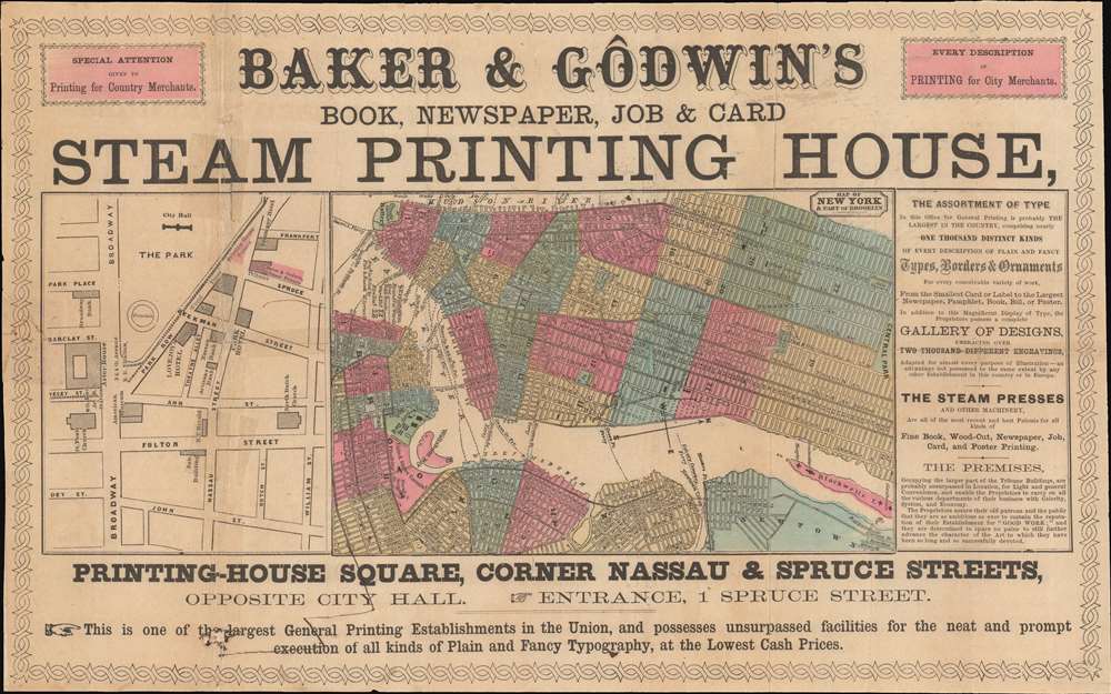
Baker and Godwin's Book, Newspaper, Job and Card Steam Printing House. / Map of New York and Port o Brooklyn.
sold
- Digital Map Information
- Suitable for large format printing
- File Size: 8.92 MB
- File Type: ZIP / TIFF
- ICC color profile embedded
- Delivered instantly via download link
An unusual ephemera map of New York City issued c. 1860 to promote the work of Baker and Godwin's steam printing. The map located at center is oriented to the west and covers New York from the Battery to Central Park, with adjacent parts of Brooklyn, Williamsburg, and Long Island City. Multiple ferry routes cross the Hudson. Adjacent to the main map a small er map focuses on the area around City Hall Park, including the triangle on Park Row known as Printing-House Square - this is essentially where the Brooklyn Bridge currently exits into Manhattan. The map is surrounded by promotional material advertising the printing firm, 'Baker and Godwin'. They were one of the first firms in New York to acquire a steam press - a tool that dramatically economized printing. (more details)
Writing about Tasmania one should visit Tasmania. - Capt. James Cook
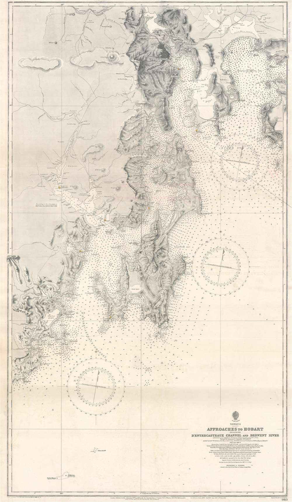
Approaches to Hobart Including D'Entrecasteaux Channel and Derwent River.
sold
- Digital Map Information
- Suitable for large format printing
- File Size: 71.76 MB
- File Type: ZIP / TIFF
- ICC color profile embedded
- Delivered instantly via download link
This is a 1921 British Admiralty nautical chart or maritime map of the approaches to Hobart, Tasmania, the Australian island state's capital and most populous city. Coverage extends from Mt. Lord south to Piedra Blanca and from Adamson Peak east to the Tasman Peninsula and Wedge Bay. Coastal bays, capes, beaches, and points, and other features are identified with countless depth soundings throughout. The Derwent River is presented in precise detail. Rivers, mountains, and other physical features near the coast are illustrated and labeled, but very little detail is present inland. The Main Line Railway, the Sorell Railway, and the Derwent Valley Railway are illustrated. (more details)
Surf's up!

East and Gulf Coast Surfing Map.
sold
A hard-to-find 1981 surfing map of the eastern United States by surf-journalist Allan 'Bank' Wright'. The visually arresting map covers the eastern two-thirds of the United States from roughly Wyoming to the Atlantic and from the Great Lakes to the Gulf of Mexico. Well known surf sites are noted along the coasts. Three legends detail specific surf spots and conditions - content that remains relevant today. The map is surrounded by photographic images of the most famous surf spots and waves. (more details)
The Space Race!

Map of the Solar System and Outer Space.
sold
This is a 1960 Book Enterprises map of the Solar System. The central map depicts our solar system from the Sun (although Mars is to the left of the Sun) to Pluto. Planetary orbits for all nine planets are color coded. Each orbit's distance from the Sun is given, as are several statistics about each planet, including its name, diameter, length of year relative to one Earth year, number of satellites, and period of rotation. Several statistics are listed as 'unknown', including the diameter of Pluto. Illustrations of the Andromeda Galaxy, the Ring Nebula, the Crab Nebula, and the Horsehead Nebula are also included. Artistic renderings of views around the solar system are situated along the right border, presenting a view of Mars from Phobos, its moon; a view of Saturn from one of its moons, Titan; and a view of the wind-blown surface of Venus. Artistic drawings of the constellations of the zodiac are situated along the top. Each sign is identified, and the Ecliptic path illustrated, with the solstices, equinoxes, and the first of each month marked. (more details)
A Sylvan, Idyllic Milwaukee.

City of Milwaukee.
sold
- Digital Map Information
- Suitable for large format printing
- File Size: 7.94 MB
- File Type: ZIP / TIFF
- ICC color profile embedded
- Delivered instantly via download link
This is an 1873 Asa Coolidge Warren view of Milwaukee, Wisconsin. The view is oriented to the west, and shows the city skyline as seen over a forest - the neighborhood which would develop into Juneau Town, almost certainly as seen from the 1855 North Point Lighthouse. The view is remarkable in that it pre-dates the 1880s architectual explosion. Later views would emphasize Milwaukee's booming factories and tall buildings: here instead is the forest that would in part become Milwaukee's Lake Park. (more details)
Get Your Kicks on Route 66! - Nat King Cole

Tips to Travelers U.S. 66 Will Rogers Highway Los Angeles to Chicago via Albuquerque, Oklahoma City, and St. Louis.
sold
- Digital Map Information
- Suitable for large format printing
- Full resolution TIFF file
- ICC color profile embedded
- Delivered instantly via download link
This is a c. 1952 Highway Travel Agency map of U.S. Route 66, also known as U.S. Highway 66, or simply as Route 66. Often call the Main Street of America, the map depicts the entirety of Route 66 in five sections on one sheet. With this map, one can easily travel from Los Angeles to Chicago without much hassle. Cities and towns along the way are labeled, including San Bernardino, Albuquerque, Flagstaff, Amarillo, Tulsa, Oklahoma City, Springfield, and Bloomington. To add further convenience to any traveler's journey, advertisements for hotels, restaurants, cafés, service stations, and campsites separate the highway sections. These advertisements make the highway sections easier to differentiate and allow travelers some understanding of where to find a warm meal, air conditioning, or a place to spend the night. Many of these are marked along the pertinent stretch of highway. More travel tips and advertisements are printed on the verso. (more details)
For military personnel visiting New York during World War II.

New York Subways.
sold
- Digital Map Information
- Suitable for large format printing
- Full resolution TIFF file
- ICC color profile embedded
- Delivered instantly via download link
An uncommon c. 1944 edition of Hagstrom's map of New York City showing subways and elevated trains, including the BMT and IRT lines. The map covers most of New York City with the exception of Staten Island. Parks are detailed, as are major avenues and streets, but the focus of the map is the subway and transit lines. Color coding defines the lines, the IRT (blue), BMT (yellow), IND (Red), and Joint lines (blue and yellow). The map also attempts to show major railway lines. (more details)