
The Classic Dutch Atlas Map of Paraguay and the Rio De La Plata

Paraguay, o Prov. De Rio De La Plata cum regionibus adiacentibus Tucuman et Sta. Cruz de la Sierra
sold
- Digital Map Information
- Suitable for large format printing
- DPI: 600
- File Size: 26.33 MB
- File Type: ZIP / TIFF
- ICC color profile embedded
- Delivered instantly via download link
A superb old color example of Blaeu's 1650 map of Paraguay. The map focuses on central South America, focusing on the course of the Rio de la Plata. The cartouche and scales are magnificently colored, and the map’s decorations include a fine compass rose and a lurking sea monster. Buenos Aires, Asuncion,Cordoba, Potosi and other modern place names appear on the map, primarily in modern day Paraguay and Argentina. (more details)
A manuscript map of a POW camp for Italian prisoners in East Africa during World War II.

Plan of Mandera Evacuation Camp.
sold
- Digital Map Information
- Suitable for large format printing
- File Size: 7.46 MB
- File Type: ZIP / TIFF
- ICC color profile embedded
- Delivered instantly via download link
A once-in-a-lifetime discovery, this is a 1942 manuscript map of the Mandera Evacuation Camp in British Somaliland (modern-day northwestern Somalia) drawn by Dino Memmo, an Italian military engineer who was tasked by the British to organize the Mandera. The Mandera Camp was created by the British to house Italian POWs and civilian internees during and after the British campaign in Italian East Africa. Despite the harsh conditions, the existence of the camps remains little more than a side note in history - here illustrated perhaps for the only time. (more details)
Marvelous separate issue chart with outstanding period guache color!

Tableau Pittoresque des Merveilles de la Nature.
sold
- Digital Map Information
- Suitable for large format printing
- DPI: 600
- File Size: 40.11 MB
- File Type: ZIP / TIFF
- ICC color profile embedded
- Delivered instantly via download link
This is a separate issue 1840 Aristide Michel Perrot and Sigismond Himely comparative chart illustrating the marvels of the nature - as they were understood in the 19th century. The present example is notable for its striking gouache color masterfully applied. The chart illustrates 58 numerically identified natural wonders, among them,
- No. 5 - the deep and picturesque Mines of Persberg, Sweden
- No. 8 - a gigantic antediluvian human skeleton fossilized.
- No. 9 - the skeleton of a wooly mammoth.
- no. 30 - the bizarre illusion of giant human beings on the side of a mountain
- no. 29 - Iceland's Mount Hekla volcano.
- No. 18 - the clifftop Corsican city of Bonifacio
- No. 12 - St. Michael's Cave in Gibraltar
Illustrates the species of animals, birds, fish, and plants that a French committee could be successfully brought to France from across the world.

Acclimatation Tableau représentant les Animaux, quadrupèdes, oiseaux, poissons, insectes, - Arbres, fruits et végétaux, propagés par la Société impériale d'Acclimatation.
sold
- Digital Map Information
- Suitable for large format printing
- DPI: 600
- File Size: 41.44 MB
- File Type: ZIP / TIFF
- ICC color profile embedded
- Delivered instantly via download link
This is a rare c. 1854 Aristide Michel Perrot and Oudart map or chart of animals, birds, fish, and trees that the French Société Impériale d'Acclimatation believed could be successfully brought to France from across the world. Seventy-five different species of animals and plants are intermixed and illustrated in brilliant gum arabic color. Some of the animals represented, such as the yak (which is described here as a cow with a horse's tail from Tibet), llama, Merino sheep, and Angora goat had already been domesticated and, in the case of the yak, used as a draft animal. The quagga, a now extinct type of zebra, is illustrated on the left next to the onager, or hemione, a species of wild ass native to Asia. With regard to the birds, the cassowary, ostrich, and rhea are among the more exotic illustrated, while the Indochinese chickens and mallard duck are perhaps the most familiar. A mandarin duck is illustrated sitting on the pond, which our New York City clients will be familiar with after one became a minor celebrity in the city after one appeared in Central Park last year and caused a minor stir among the city's residents. A kangaroo, bison, and water buffalo are also among the species presented. (more details)
Scarce 1775 English Map Prefiguring A British Colonial Presence in Central America.
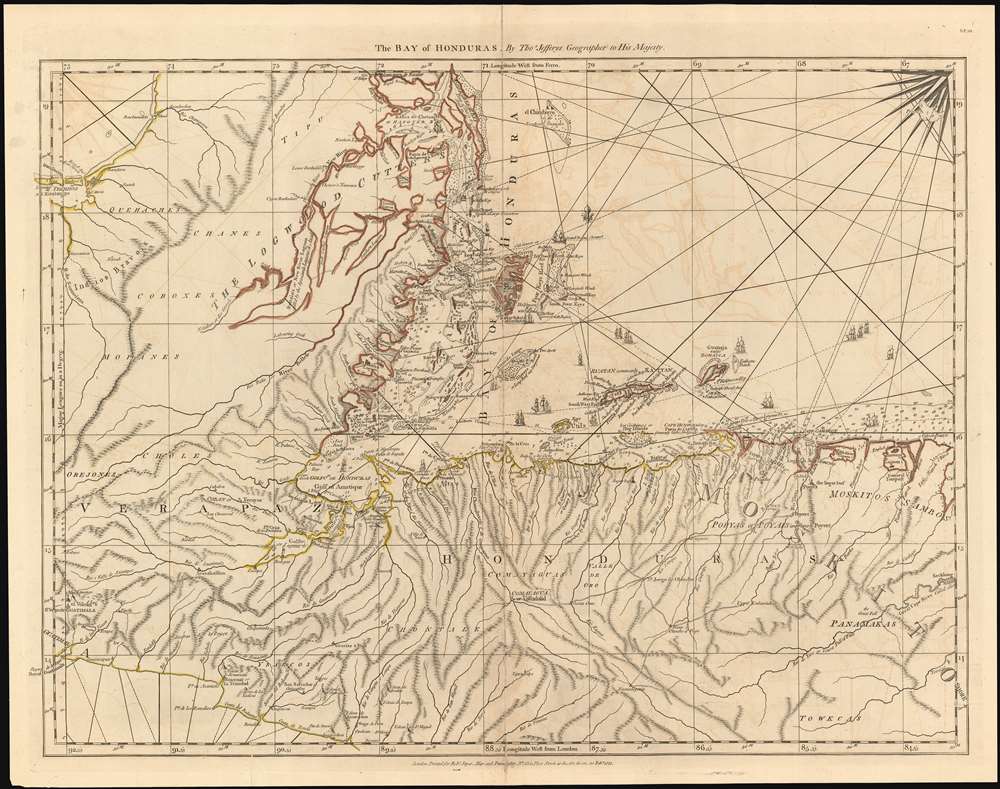
The Bay of Honduras. By Thos. Jefferys Geographer to His Majesty.
sold
- Digital Map Information
- Suitable for large format printing
- DPI: 600
- File Size: 51 MB
- File Type: ZIP / TIFF
- ICC color profile embedded
- Delivered instantly via download link
This 1775 Jefferys map of Belize, Honduras, Guatemala and El Salvador is the earliest, acquirable, detailed map to focus on the region. It is informationally rich, showing anchorages, depth soundings and common sailing routes (replete with dozens of ships.) The region’s plentiful reefs, islands and lagoons are shown and named. This map brings into sharp focus coastal Belize and Honduras where English privateers and merchants had long operated – shortly after Spain began to tolerate their presence, but just prior to Britain’s official administration of Belize as a colony. (more details)
The first comprehensive and accurate general geological map of East Africa.
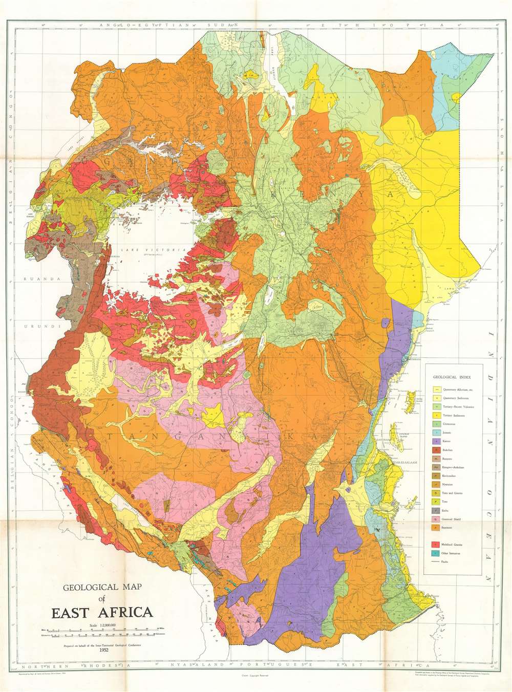
Geological Map of East Africa.
sold
- Digital Map Information
- Suitable for large format printing
- File Size: 65.01 MB
- File Type: ZIP / TIFF
- ICC color profile embedded
- Delivered instantly via download link
A striking piece, this is a 1952 Geological Survey Department of Tanganyika (modern-day Tanzania) geological map of British East Africa and the first comprehensive and accurate general geological map of Africa. The map depicts the region from Rwanda, Burundi, and Lake Tanganyika to the Indian Ocean and from Ethiopia and Sudan to Northern Rhodesia, Portuguese East Africa, and Lake Nyasa. Highlighting the geology of the modern-day countries of Kenya, Uganda, and Tanzania, nineteen different geological formations are identified in a 'geological index' situated in the lower right corner along the right border. The region where each formation has been identified is shaded the corresponding color and labeled with the small letter noted in the index. Fault lines running through the region are marked by solid black lines. Cities and towns are identified throughout, including Nairobi, Dar es Salaam, Entebbe, and Zanzibar. Topographical features, such as Mount Kenya and the Rift Valley, are also illustrated and labeled. (more details)
Japan meets the world - an influence for the development of western pictorial cartography.

Round the World Competition. / 世界一週競争双六
sold
- Digital Map Information
- Suitable for large format printing
- File Size: 44.41 MB
- File Type: ZIP / TIFF
- ICC color profile embedded
- Delivered instantly via download link
A scarce 1926 Japanese 'round the world' sugoroku game and pictorial map of the world by Saburo Ota (太田三郎). The game board takes the form of an allegorical map of the world centered on Japan. The continents are amorphous but recognizable. Vignette illustrations throughout depicts cultural figures, architectural wonders, flora, fauna, and Japanese people engaging with the world. Three cities are specifically highlighted, Tokyo which acts as the starting point or furi-dashi), and New York and London, servings as optional endpoints or agari. The verso features an image of a 'family athletic meet.' (more details)
Illustrates a South Carolina - Georgia border dispute.
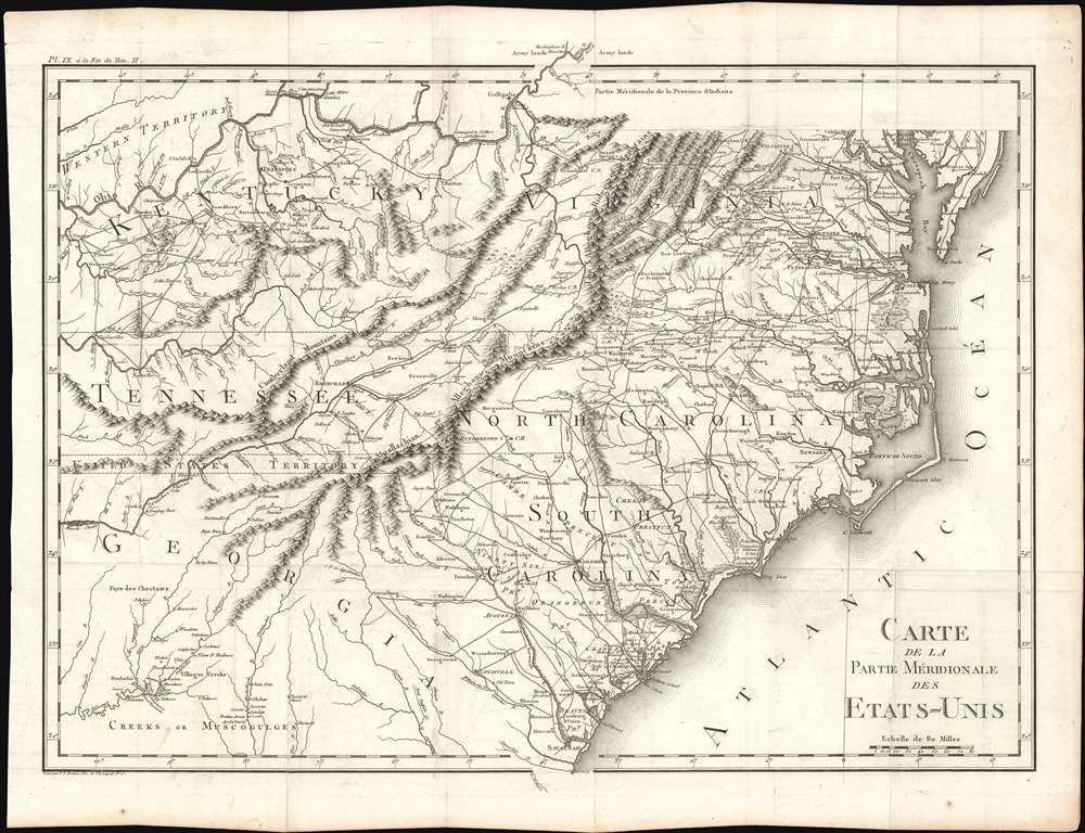
Carte De La Partie Méridionale Des Etats-Unis.
sold
- Digital Map Information
- Suitable for large format printing
- DPI: 600
- File Size: 22.63 MB
- File Type: ZIP / TIFF
- ICC color profile embedded
- Delivered instantly via download link
An important and highly detailed 1801 map of the southeastern United States by Pierre Francis Tardieu. The map was issued to a accompany Michel Guillaume de Crevecoeur's Le Voyage dans la Haute Pennsylvania et dans l'État de New-York, one of the most important post-Revolutionary War books about life and economy in the fledgling United States. Coverage extends from the Chesapeake Bay and the Ohio River south as far as central Georgia, including the modern-day states of Virginia, Kentucky, Tennessee, North Carolina, South Carolina, and parts of Georgia and Alabama. The map is notable for its exceptional detail, naming towns, mills, mines, and roads, as well as surveyed tracts intended to compensate Revolutionary War soldiers for their effort. (more details)
A 19th century map of the City of London featuring St. Paul's Cathedral.
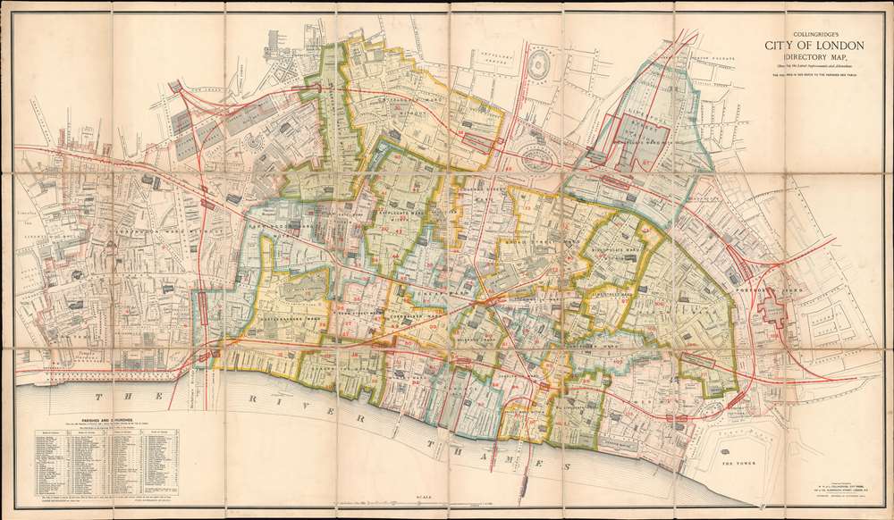
Collingridge's City of London Directory Map, Shewing the Latest Improvements and Alterations.
sold
- Digital Map Information
- Suitable for large format printing
- File Size: 86.48 MB
- File Type: ZIP / TIFF
- ICC color profile embedded
- Delivered instantly via download link
This is a rare first edition 1885 William Hill and Leonard Collingridge city map or plan of the City of London. The map depicts the city from the Royal Courts of Justice to Goodman's Fields and from Goswell Road to the Thames River and the Tower of London. Meticulously detailed, individual buildings throughout the city are illustrated. Churches are the most easily identified, as they are shaded with black diagonal lines. St. Paul's Cathedral is situated in the lower left quadrant. Halls, banks, offices, colleges, post offices, hospitals, and police stations are all identified. Squares and streets are labeled throughout. City wards are labeled in block lettering and outlined and shaded in various colors to allow for easy differentiation. The red numbers identify parishes. Rail lines are highlighted by thick red lines, which also outline rail stations. Wonderful detail is included as well, such as the trees illustrated along Victoria Embankment, in the Temple Gardens, and along King's Bench Walk. (more details)
Stunning pictorial map of China during the Boxer Rebellion.
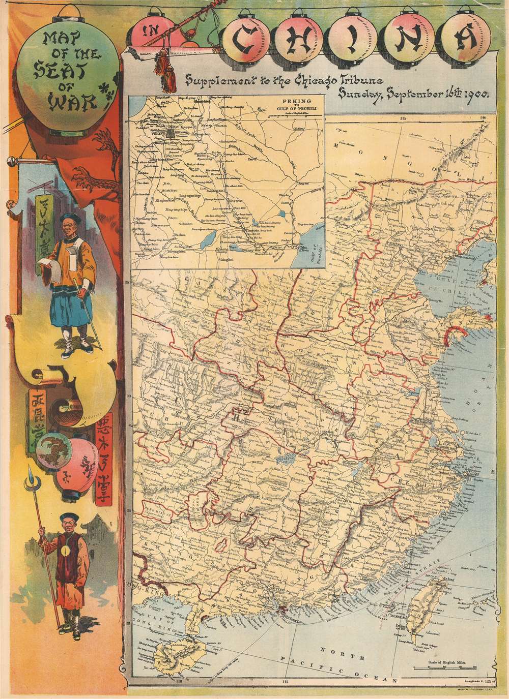
Map of the Seat of War in China. Supplement to the Chicago Tribune, Sunday, Septemer 16th 1900.
sold
- Digital Map Information
- Suitable for large format printing
- File Size: 26.67 MB
- File Type: ZIP / TIFF
- ICC color profile embedded
- Delivered instantly via download link
This is a rare chromolithograph pictorial map of China issued by the Chicago Tribune on Sunday, September 16, 1900, to illustrate the events of the Boxer Rebellion or Yihetuan Movement. The map details China from Hainan to the Mongolia and from Sichuan to the China Sea. An inset details the route from Peking to the Gulf of Pechili (Bohai Sea), where most of the action of the Boxer Rebellion took place. The surround is of particular reference and features illustrations of armed Boxers and chinoiserie lettering on Chinese style hanging lanterns. (more details)
Distributed by the USO for service men and women serving in Honoluly during World War II.

A Map and Bus Guide of Honolulu Issued for Service Men and Women by the USO of Hawaii.
sold
- Digital Map Information
- Suitable for large format printing
- File Size: 20.57 MB
- File Type: ZIP / TIFF
- ICC color profile embedded
- Delivered instantly via download link
This is a c. 1944 James B. Mann and USO of Hawaii city map or plan of Honolulu, Hawaii issued for service men and women during World War II. The map depicts the city from Moanalua Gardens to Kahala Beach and from Dowsett Highlands to Diamond Head. As this map served as a guide for people unfamiliar with Honolulu, myriad streets throughout the city are illustrated and labeled. Numerous sites are also identified, including beaches, parks, forts, stadiums, schools, canneries, and, of course, golf courses. Thick red lines overlaid on the map highlight bus routes, obviously meant to encourage service men and women from buying cars and instead to use mass transportation. An inset of downtown Honolulu is situated in the upper right corner and illustrates the bus network in this popular part of the city and identifies theaters and public and historic buildings. An inset in the upper left corner depicts Navy and Civilian Housing Areas 1-2-3. Between the two insets is a detailed commentary on downtown bus transfers. A third and final inset in the lower left corner details the bus network linking Pearl Harbor and Hickam Field with Honolulu and Woodland. (more details)
Evocative of the Romance of the Amerian West - Grand Teton National Park!
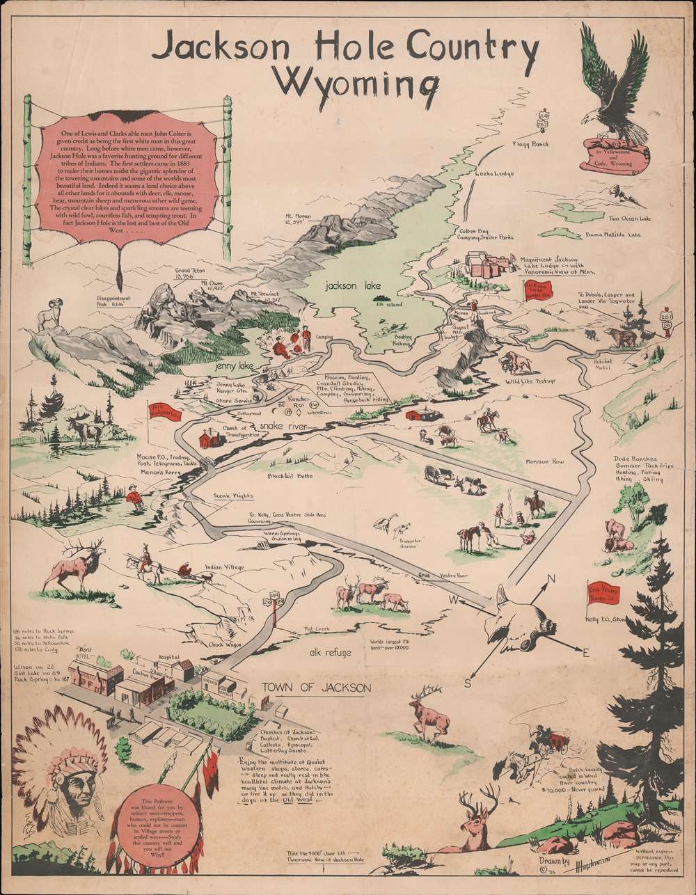
Jackson Hole Country Wyoming.
sold
- Digital Map Information
- Suitable for large format printing
- File Size: 25.4 MB
- File Type: ZIP / TIFF
- ICC color profile embedded
- Delivered instantly via download link
An attractive and rare 1956 pictorial view map of Jackson Hole, Wyoming, drawn by Harold Isadore Hopkinson. Oriented to the northwest, the map covers roughly from Jackson Lake in Grand Teton National Park to the town of Jackson, appearing in the lower left. The view capitalizes on the romance of the American west, featuring American Indians, cowboys, elk, moose, big horn sheep, and has a desiccated cow skull integrated into the compass rose. A text element in the upper left offers a brief history of Jackson Hole. (more details)
A detailed look at the Siege of Petersburg including the Battle of Five Forks, a key victory in forcing the surrender of the Army of Northern Virginia by Robert E. Lee.
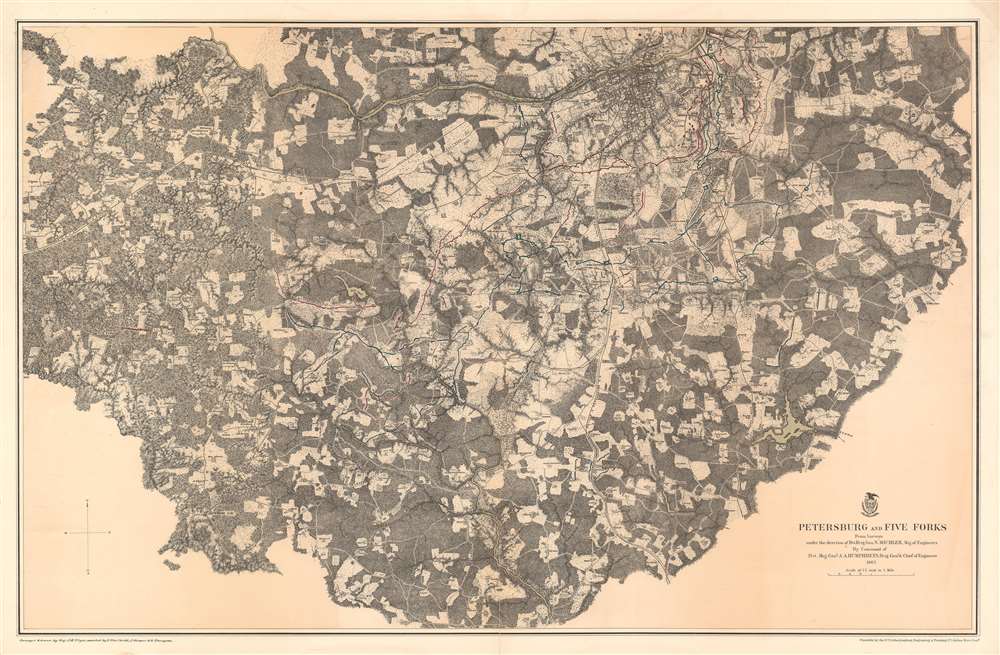
Petersburg and Five Forks.
sold
- Digital Map Information
- Suitable for large format printing
- File Size: 75.14 MB
- File Type: ZIP / TIFF
- ICC color profile embedded
- Delivered instantly via download link
This is an 1867 John Weyss and Nathaniel Michler map of Petersburg and Five Forks, Virginia illustrating the Siege of Petersburg during the American Civil War (1862 - 1865). The map depicts the region from Five Forks to Prince George Court House and from the river road north of the Appomattox River to Malone's Bridge on Rowanty Creek. (more details)
The first map of Northen Italy based on modern scientific survey techniques.

(Northern Italy)
sold
- Digital Map Information
- Suitable for large format printing
- DPI: 600
- File Size: 8.14 MB
- File Type: ZIP / TIFF
- ICC color profile embedded
- Delivered instantly via download link
Issued in 1554 by Sebastian Münster, this is one of the earliest printed maps of Northern Italy based on contemporaneous data. The southern-oriented map shows the peninsula from Naples northwards to the Alps. Cities include Rome, Florence, Pisa, Turin, Genoa, and Venice. The broader regions of Campania, Abruzzo, and Lombardy are labeled. Corsica and the city of Aleria, as well as Sardinia and the city of Sardos appear as well. (more details)
A pictorial map promoting Richard Byrd's second expedition to the Antarctic and the radio broadcasts he made along the way.

Authorized Map of the Second Byrd Antarctic Expedition.
sold
- Digital Map Information
- Suitable for large format printing
- File Size: 34.25 MB
- File Type: ZIP / TIFF
- ICC color profile embedded
- Delivered instantly via download link
This is a fascinating 1934 George Annand pictorial map of Antarctica celebrating the second Antarctic expedition of Rear Admiral Richard E. Byrd. It beautifully illustrates the South Polar Region, including the southern tip of South America and the eastern tip of New Zealand. Explored regions of Antarctica are identified along the coast, especially near the Ross Sea. Unexplored regions are also labeled. The title cartouche is adorned with a sled dog, a compass rose, penguins, and the portrait of the man himself Richard Evelyn Byrd. A note below the title reads, 'Past polar expeditions have been swallowed up by a silence which was never broken until they returned--if they did return. But on the Byrd Expedition there is being attempted the most notable feat in radio history--a two-way broadcast of the Expedition as it is being lived--from the very lips of the men themselves. Hailed by leading authorities as an important contribution to radio science, this series is made possible by General Foods, makers of Grape-Nuts'. Two insets, on the top left and bottom right quadrants respectively, detail the 'Route of Expedition and Path of the Broadcast', and 'The Bay of Whales'. A detail map of Little America (the expedition base camp on Ross Ice Shelf) is included within the inset of the Bay of Whales. Other illustrations of whales, penguins, ships, and airplanes, among other things, are included throughout.
A banner over the South Pole indicates the previous expeditions of Amundsen in 1911, Scott in 1912 and Byrd's first expedition in 1929. The second Byrd expedition took place in 1934, and it was during this second expedition that Byrd spent five cold months alone at Advance Base and almost died. He would later describe his ordeal in his autobiography Alone. (more details)
A banner over the South Pole indicates the previous expeditions of Amundsen in 1911, Scott in 1912 and Byrd's first expedition in 1929. The second Byrd expedition took place in 1934, and it was during this second expedition that Byrd spent five cold months alone at Advance Base and almost died. He would later describe his ordeal in his autobiography Alone. (more details)
Includes the Arredondo Land Grant.

Florida.
sold
- Digital Map Information
- Suitable for large format printing
- File Size: 12.33 MB
- File Type: ZIP / TIFF
- ICC color profile embedded
- Delivered instantly via download link
This is an 1857 J.H. Colton map of Florida. Like most of Colton's state maps, this map is largely derived from an earlier wall map of North America produced by Colton and D. Griffing Johnson. In this particular case, Colton has augmented his map with the plat work done by the Florida branch of the U.S. Land Survey.
Cities, towns, forts, rivers, rapids, fords, and an assortment of additional topographical details are recorded throughout the state. An inset in the lower left quadrant details the Florida Keys. Counties are shaded different colors to allow for easy differentiation. This map would prove to be a prototype for a number of maps to follow by such noted cartographers as Johnson and Gray. (more details)
Cities, towns, forts, rivers, rapids, fords, and an assortment of additional topographical details are recorded throughout the state. An inset in the lower left quadrant details the Florida Keys. Counties are shaded different colors to allow for easy differentiation. This map would prove to be a prototype for a number of maps to follow by such noted cartographers as Johnson and Gray. (more details)
Map of the Mediterranean showing the tracks of Aenaeas, Telemachus, and Ulysses.
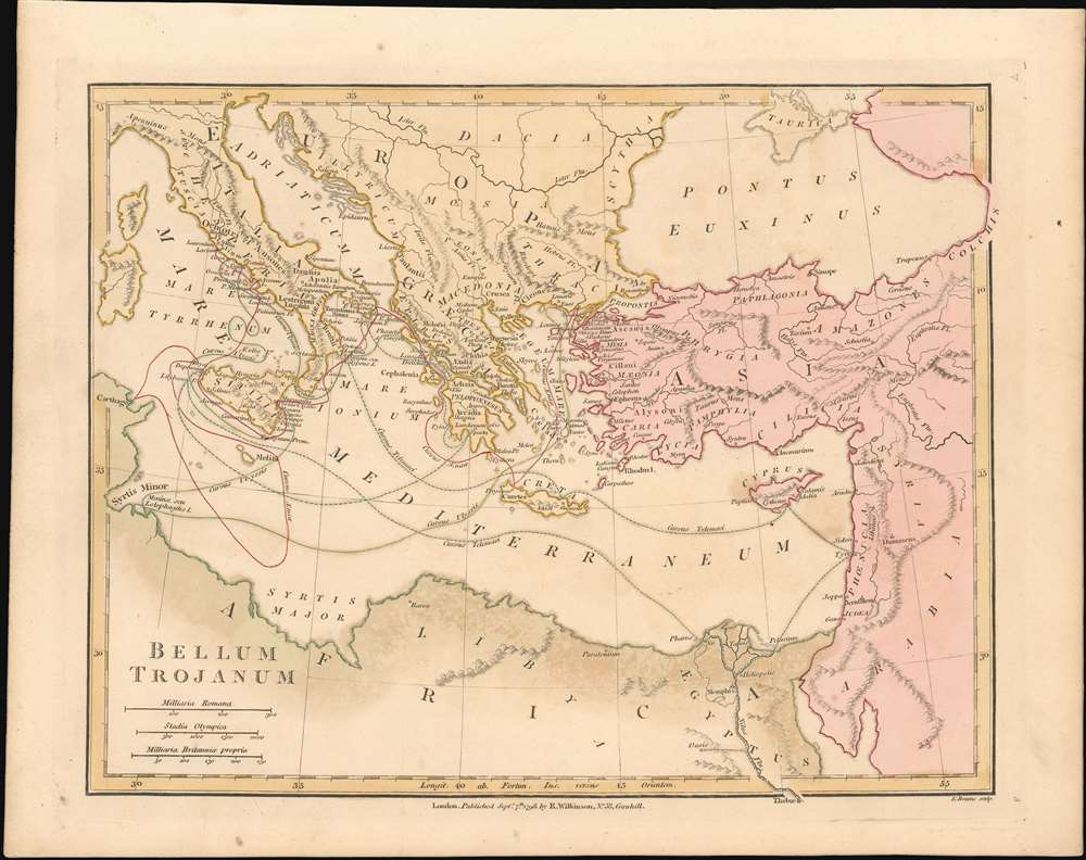
Bellum Trojanum
sold
- Digital Map Information
- Suitable for large format printing
- DPI: 600
- File Size: 7.91 MB
- File Type: ZIP / TIFF
- ICC color profile embedded
- Delivered instantly via download link
This is a fine 1798 map of the Eastern Mediterranean by Robert Wilkinson, focusing on the region encompassing the events of Homer’s Odyssey and Virgil’sAeneid, and showing the travels of its principal characters. Wilkinson's map covers from Carthage to Syria, reaching as far north as the Black Sea; in the south, the Nile River extends beyond the border of the map. Italy and the Greek Islands are, of course, shown in detail. Although the place names are the ancient ones relevant to the events described in the epic poems, the topography of the map is modern. (more details)
Mitchell's map of California with inset of the Great Salt Lake.
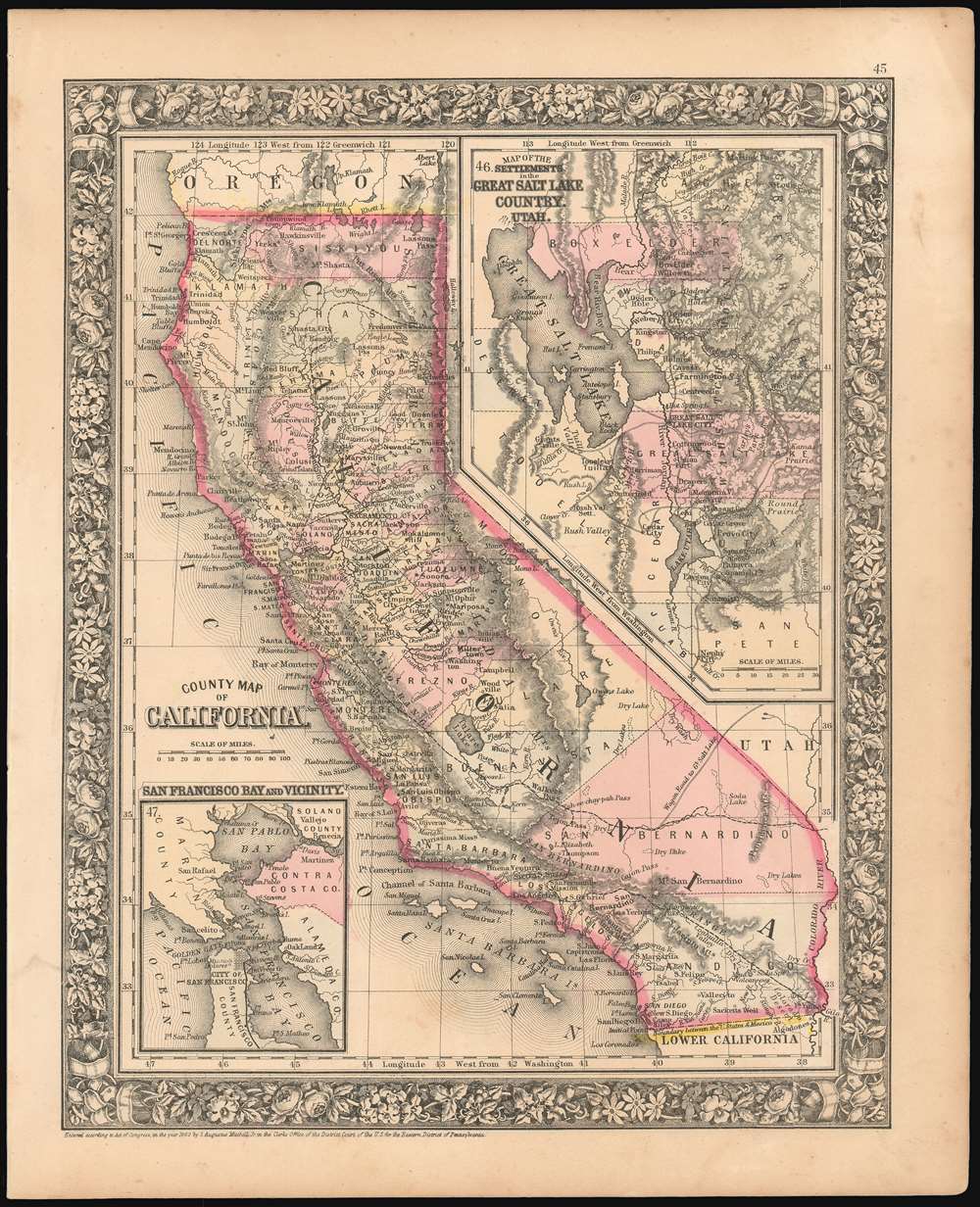
County Map of California.
sold
- Digital Map Information
- Suitable for large format printing
- Full resolution TIFF file
- ICC color profile embedded
- Delivered instantly via download link
A scarce 1866 S. A. Mitchell map of California covering not only that state, but also including a detailed inset map of the region surrounding the Great Salt Lake in Utah, showing the settlements there. Another inset, in the lower left quadrant, details San Francisco Bay. Each region is rendered in considerable detail. The map shows the proposed routes for the Southern Pacific and Central Pacific Rail Roads, and includes some of California’s first completed rail lines, connecting Sacramento with Placerville and Marysville. The San Francisco and San Jose Railroad can be seen connecting those two cities, both on the general map and on the detail of the Bay area. The Salt Lake City regional map does not, of course, show railways, but wagon routes between settlements are clearly marked. Topography is indicated with hachures. The map is hand colored, highlighting the map according to county. (more details)
The most detailed complete map of Singapore Island to appear in the 1950s.

Singapore 1958.
sold
- Digital Map Information
- Suitable for large format printing
- Full resolution TIFF file
- ICC color profile embedded
- Delivered instantly via download link
An extremely important and scarce set of Singapore Maps issued in 1958 under the Surveyor General Malaya. This map set was created during the 1955 - 1958 period of partial internal self-governance and compilated in the year Singapore attained full internal self-governance. The maps cover all of Singapore island as well adjacent islands, and include two supplementary maps, one focusing on Keppel Harbor, and the other extending the coverage eastward to Pulau Tekong. The detail throughout is astounding, with individual buildings, alleyways, roads, and more identified. A key shows the locations of temples (noting religious affiliation), hospitals, schools, government offices, dispensaries, community centers, and fire stations, and other constructions. The map also notes topography, geographical features, the extent of natural and cultivated vegetation, maritime details. (more details)
First official Bi-Lingual Map of Singapore issued after Malaysian Independence.

Map of Singapore City. / 新嘉坡市區地圖
sold
- Digital Map Information
- Suitable for large format printing
- File Size: 99.11 MB
- File Type: ZIP / TIFF
- ICC color profile embedded
- Delivered instantly via download link
This is an extremely rare large format 1958 first edition map of Singapore in Chinese and English. Being published just one year after the 1957 Treaty of London recognized the independence of the Federation of Malaysia – which then included Singapore - and in the year that Singapore formally attained internal self-governance. The political transition led to a wave of new bi-lingual publications as English was no longer the only official language. Maps in multiple languages became a necessity both for functional and administrative use. (more details)