
A charming pictorial map tracing the life of George Washington from the French and Indian War through his years as President of the United States.

Principal Events in the life of George Washington in this States that lie between the Hudson and Savannah.
sold
- Digital Map Information
- Suitable for large format printing
- File Size: 11.57 MB
- File Type: ZIP / TIFF
- ICC color profile embedded
- Delivered instantly via download link
This is a c. 1932 General Drafting Company pictorial map of principal events and important sites in the life of George Washington, the First President of the United States and the Commander-in-Chief of the Continental Armies during the American Revolutionary War. ... (more details)
Captures the wonder and sense of adventure felt by all at the advent of space exploration.

The Amoco Map of Space Mysteries.
sold
This is a 1958 Rudy de Reyna pictorial map of speculative space exploration. Created within a year of the launch of the Soviet satellite Sputnik 1 , the map proposes that many of the mysteries of the universe that, up until 1958 had remained unsolved by humanity, ... (more details)
Depicts the ephemeral Confederate Arizona Territory and is one of the first maps to illustrate Colorado.
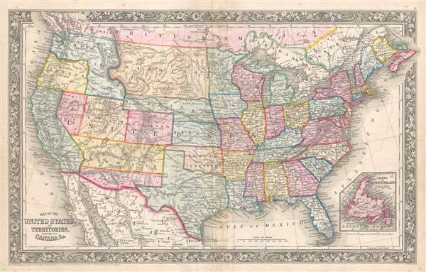
Map of the United States and Territories. Together with Canada etc.
sold
- Digital Map Information
- Suitable for large format printing
- Full resolution TIFF file
- ICC color profile embedded
- Delivered instantly via download link
This is a Samuel Augustus Mitchell, Jr. map of the United States during the first year of the American Civil War which illustrates the ephemeral Confederate Arizona Territory and is one of the first maps to include the newly-formed Colorado Territory and Dakota ... (more details)
Extraordinary and rare blueback nautical chart of the East Coast.
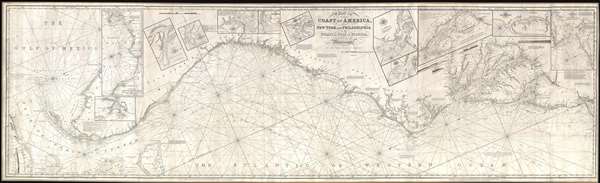
Chart of the Coast of America, from New York and Philadelphia, to the Strait or Gulf of Florida, and from thence to the Mississippi.
sold
- Digital Map Information
- Suitable for large format printing
- Full resolution TIFF file
- ICC color profile embedded
- Delivered instantly via download link
An utterly spectacular and sprawling 1850 John Williams Norie blueback nautical chart or maritime map depicting the North American coastline from New York to the Florida Keys. The map is oriented to the west, as a navigator from Europe would approach the ... (more details)
One of the few English Blueback chart published by a woman, Penelope Steel, and one of the first to be made from surveys using a Marine Chronometer.
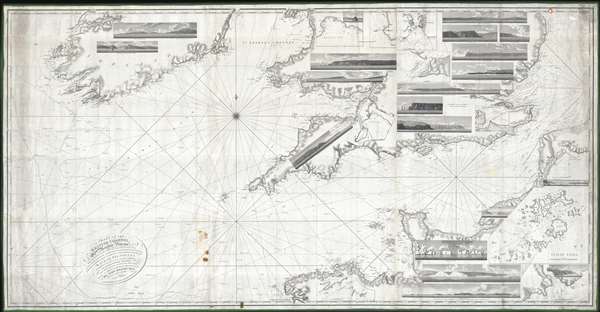
A Chart of the British Channel, On Mercator's Projection.
sold
- Digital Map Information
- Suitable for large format printing
- DPI: 300
- File Size: 324.15 MB
- File Type: ZIP / TIFF
- ICC color profile embedded
- Delivered instantly via download link
This is a first edition of Penelope Steel's magnificent 1804 nautical chart or maritime map of the English Channel. This is one of the few blueback charts published by a woman bearing a woman's imprint – in this case, Penelope Steel, the widow of David Steel. Based upon the c. 1802 survey work of Captain John Steel, one of the first surveys of the English Channel to be completed with the newly invented 'H5' marine chronometer.
The map's coverage extends from the western shores of Ireland to the coasts of France, including the English Channel, Bristol Channel, and part of St. Georges Channel. The chart further includes 18 shore profile views and inset maps of Mount's Bay, Portsmouth Harbor, the western part of the Isle of Wight, Portland Harbor, Sheerness, Exmouth Bar, Dartmouth, St. Vincent's Passage, and the Scilly Isles. (more details)
The map's coverage extends from the western shores of Ireland to the coasts of France, including the English Channel, Bristol Channel, and part of St. Georges Channel. The chart further includes 18 shore profile views and inset maps of Mount's Bay, Portsmouth Harbor, the western part of the Isle of Wight, Portland Harbor, Sheerness, Exmouth Bar, Dartmouth, St. Vincent's Passage, and the Scilly Isles. (more details)
The only 'realistic' view of the most notorious Anderson confederate Civil War Prison.
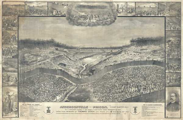
Andersonville Prison. Camp Sumter, GA. As It Appeared August 1st, 1864 When It Contained 35,000 Prisoners of War.
sold
- Digital Map Information
- Suitable for large format printing
- File Size: 378.82 MB
- File Type: ZIP / TIFF
- ICC color profile embedded
- Delivered instantly via download link
This is an 1885 large-format Thomas O'Dea view of the infamous Confederate Civil War Prisoner of War Camp at Andersonville, Georgia. After the Civil War, Andersonville became synonymous with the horrors the country inflicted on itself, encapsulating the ... (more details)
Rare bird's-eye view of Williams College campus.

Williams College.
sold
- Digital Map Information
- Suitable for large format printing
- File Size: 14.86 MB
- File Type: ZIP / TIFF
- ICC color profile embedded
- Delivered instantly via download link
This is a rare 1906 Richard Rummell view of Williams College, a private liberal arts college located in Williamstown, northwestern Massachusetts. The view looks west along modern day Spring Street (Route 2), through Williams College toward the ... (more details)
Rare bird's-eye view of the University of Michigan campus.

University of Michigan.
sold
- Digital Map Information
- Suitable for large format printing
- File Size: 14.92 MB
- File Type: ZIP / TIFF
- ICC color profile embedded
- Delivered instantly via download link
This is a rare 1908 Richard Rummell view of the campus of the University of Michigan. The view reveals the historical campus looking to the northwest from a point about 300 feet above the intersection of South State Street and South University ... (more details)
One of the earliest published maps of the lower Mississippi Valley.
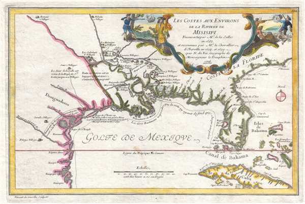
Les Costes aux Environs de la Riviere de Misisipi.
sold
- Digital Map Information
- Suitable for large format printing
- DPI: 300
- File Size: 2.79 MB
- File Type: ZIP / TIFF
- ICC color profile embedded
- Delivered instantly via download link
An uncommon map of often neglected and misunderstood significance, this is Nicolas de Fer's 1705 map of the Gulf Coast, Florida, and Texas, one of the earliest published maps to show any significant detail of the lower Mississippi Valley. De ... (more details)
Uncommon map illustrating nascent French colonial expansionism before the French and Indian War.

Le Canada, ou Nouvelle France La Floride, La Virginie, Pensilvanie, Caroline, Nouvelle Angleterre et Nouvelle Yorck, I'Isle de Terre Neuve, La Louisiane et le Courss de la Riviere de Misisipi.
sold
- Digital Map Information
- Suitable for large format printing
- DPI: 300
- File Size: 3.62 MB
- File Type: ZIP / TIFF
- ICC color profile embedded
- Delivered instantly via download link
This is a 1705 map of North America east of the Mississippi River by French cartographer Nicolas De Fer. Centered roughly on the Great Lakes and the Hudson Valley, this map depicts from the Mississippi River east to Newfoundland and the ... (more details)
Includes a fantastic illustration of the legendary Mines de St. Barbe / Santa Barbara silver mines.
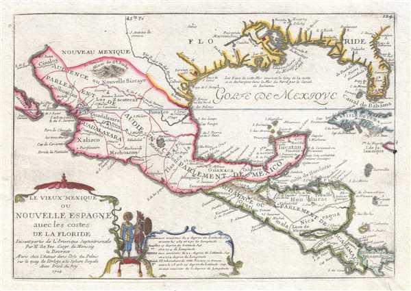
Le Vieux Mexique ou Nouvelle Espagne avec les costes de la Floride.
sold
- Digital Map Information
- Suitable for large format printing
- DPI: 300
- File Size: 3.04 MB
- File Type: ZIP / TIFF
- ICC color profile embedded
- Delivered instantly via download link
An uncommon 1705 map by Nicolas De Fer of Mexico, the Gulf Coast, and Florida. Centered on the Gulf of Mexico, this map depicts from Baja California to Florida and Cuba, covering in the process, the Gulf of Mexico, parts of New Mexico ... (more details)
Illustrates St. Brenden's Island and Post-French and Indian War political configuration.
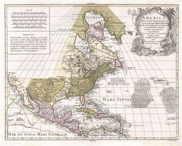
America Septentrionalis, concinnata juxta observationes Dñn Academiæ Regalis Scientiarum et nonnullorum aliorum, et juxta annotationes recentissimas…
sold
- Digital Map Information
- Suitable for large format printing
- DPI: 300
- File Size: 10.91 MB
- File Type: ZIP / TIFF
- ICC color profile embedded
- Delivered instantly via download link
A visually striking c. 1772 old color Tobias Conrad Lotter map of North America. Centered roughly on New York City, the map covers from Baffin Bay to the northern part of South America and from California to the Azores. ... (more details)
Map of Mexico City before the draining of Lake Texcoco.
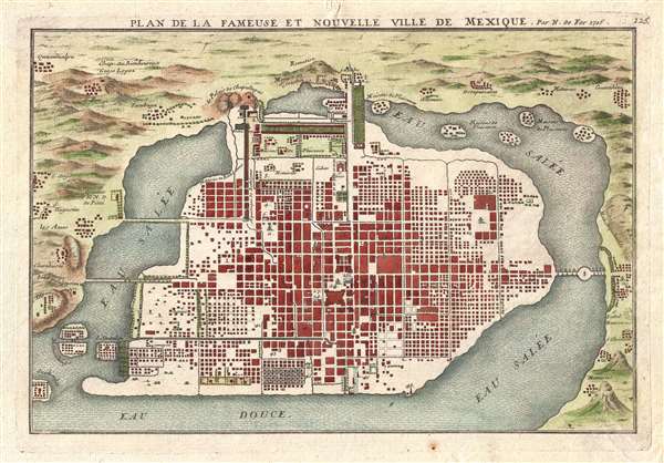
Plan de la Fameuse et Nouvelle Ville de Mexique.
sold
- Digital Map Information
- Suitable for large format printing
- DPI: 300
- File Size: 3.8 MB
- File Type: ZIP / TIFF
- ICC color profile embedded
- Delivered instantly via download link
This is a 1715 Nicolas de Fer city map or plan of Mexico City, Mexico. Although somewhat hard to correlate to the sprawling modern day Mexico City, this map illustrates Mexico shortly after being constructed from the ... (more details)
Illustrates the Old CIty and the Temple Mount in detail.

Jerusalem Old and New.
sold
- Digital Map Information
- Suitable for large format printing
- File Size: 11.34 MB
- File Type: ZIP / TIFF
- ICC color profile embedded
- Delivered instantly via download link
This is a 1942 Steimatzky pictorial map of Jerusalem. The map depicts the city from Karem es Sila to El Tur and the Mount of Olives and from the Hadassa Medical Center, the Hebrew University and Mt. Scopus to Meqor ... (more details)
A charming broadside promoting Martha's Vineyard as a vacation destination - the only known example.
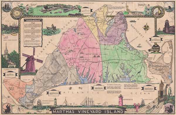
Martha's Vineyard Island.
sold
- Digital Map Information
- Suitable for large format printing
- File Size: 12.59 MB
- File Type: ZIP / TIFF
- ICC color profile embedded
- Delivered instantly via download link
This is L. H. Parker's c. 1935 pictorial map of Martha's Vineyard. The map depicts the entirety of Martha's Vineyard from Gay Head and Gay Head Lighthouse to Chappaquiddick Island and from the West Chop Lighthouse ... (more details)
The world as it was at the outset of American combat operations during World War II.
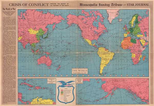
Crisis of Conflict Involves the Destiny of All Nations of the Earth.
sold
- Digital Map Information
- Suitable for large format printing
- File Size: 18.94 MB
- File Type: ZIP / TIFF
- ICC color profile embedded
- Delivered instantly via download link
This is a 1942 Minneapolis Sunday Tribune and Star Journal map of the world at the outset of American involvement in World War II. With North America at center, the map depicts the world from Central Asia across ... (more details)
Beautiful nautical chart detailing the entrance to San Francisco Bay before the Golden Gate Bridge was built.

Preliminary Chart of Entrance to San Francisco Bay California.
sold
- Digital Map Information
- Suitable for large format printing
- File Size: 11.13 MB
- File Type: ZIP / TIFF
- ICC color profile embedded
- Delivered instantly via download link
This is an 1856 U. S. Coast Survey nautical chart or maritime map of the entrance to San Francisco Bay and San Francisco itself. Centered on the City of San Francisco, the map depicts the Golden Gate Area, the ... (more details)
Incredible coastal detail - including the James, York, and Rappahannock Rivers.

Sketch C Showing the Progress of the Survey in Section No. III from 1843 to 1856.
sold
- Digital Map Information
- Suitable for large format printing
- File Size: 12.76 MB
- File Type: ZIP / TIFF
- ICC color profile embedded
- Delivered instantly via download link
This is an 1856 U.S. Coast Survey nautical chart or maritime map of Chesapeake Bay and Delaware Bay. The map depicts the region from Susquehanna, Maryland to the northern Outer Banks in North Carolina and from ... (more details)
An incredible large format separate issue nautical chart of the entrance to San Francisco Bay.

Entrance to San Francisco Bay California.
sold
- Digital Map Information
- Suitable for large format printing
- File Size: 18.05 MB
- File Type: ZIP / TIFF
- ICC color profile embedded
- Delivered instantly via download link
This is a separate issue example of the 1859 U. S. Coast Survey nautical chart or maritime map of the entrance to San Francisco Bay and San Francisco itself. Centered on the City of San Francisco, the map ... (more details)
A separate issue edition of an attractive nautical chart of southern California.
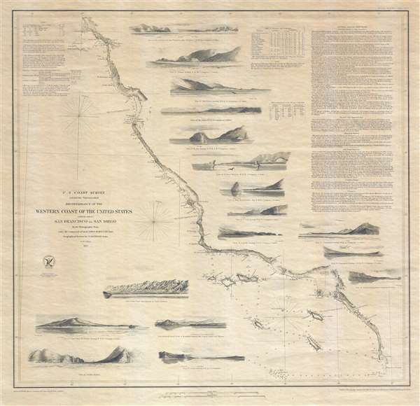
Reconnaissance of the Western Coast of the United States (Lower Sheet) San Francisco to San Diego.
sold
- Digital Map Information
- Suitable for large format printing
- DPI: 300
- File Size: 10.02 MB
- File Type: ZIP / TIFF
- ICC color profile embedded
- Delivered instantly via download link
This is a separate issue example of the 1853 United States Coast Survey nautical chart or maritime map of the coast of California and it is one of the most attractive and desirable of the original U.S. ... (more details)