
A landmark - a great cartographical achievement … -Wheat

A Map of North America Constructed According to the Latest Information by H. S. Tanner.
sold
- Digital Map Information
- Suitable for large format printing
- DPI: 300
- File Size: 68.73 MB
- File Type: ZIP / TIFF
- ICC color profile embedded
- Delivered instantly via download link
An attractive example of Henry Schenk Tanner's remarkable 1825 landmark map of North America, considered to be the most important map of North America of the 19th century. Revolutionary in countless ways, this is the most accurate map of North America, in ... (more details)
Stunning separate issue flag chart with New England Globe Flag - First flag of New England!
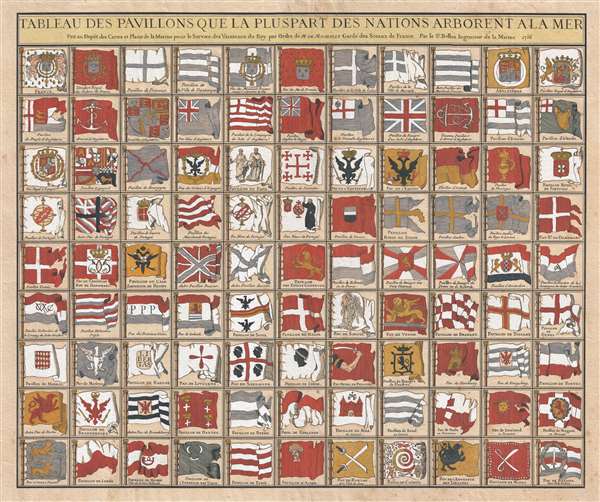
Tableau des Pavillons Que la PulPart des Nations Arborent a La Mer.
sold
- Digital Map Information
- Suitable for large format printing
- DPI: 300
- File Size: 24.93 MB
- File Type: ZIP / TIFF
- ICC color profile embedded
- Delivered instantly via download link
One of the most beautiful and interesting separate issue flag charts we have found, this stunning chart by Jacques Nicolas Bellin was issued in 1756, at the opening of the French and Indian War or Seven Years War (1756 - 1763). The flags represented are ... (more details)
One French Revolution Blue Paper! Indentfies early settlements west of the Appalachian Mountains.
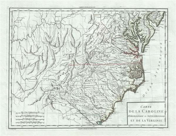
Carte de la Caroline Meridionale et Septentrionale et de la Virginie.
sold
- Digital Map Information
- Suitable for large format printing
- DPI: 300
- File Size: 9.54 MB
- File Type: ZIP / TIFF
- ICC color profile embedded
- Delivered instantly via download link
A scarce 1795 map of Virginia and Carolina by Pierre François Tardieu notable for its identification of early trade routes and settlements west of Appalachia. The map is rare and exquisitely engraved detailing the middle-southeast Atlantic seaboard covering from the Delaware Bay to the Savannah River and inland as far as modern-day Iowa. It is notably printed on high quality light blue handkerchief paper that briefly appeared during the French Revolution. (more details)
The largest separate issue comparative mountains chart we have yet discovered.
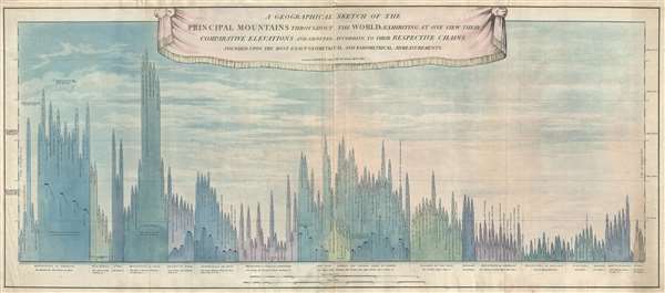
A Geographical Sketch of the Principal Mountains throughout the World; exhibiting at one view their comparative elevations and grouped according to their respective chains founded upon the most exact geometrical admeasurments.
sold
- Digital Map Information
- Suitable for large format printing
- DPI: 300
- File Size: 29.56 MB
- File Type: ZIP / TIFF
- ICC color profile embedded
- Delivered instantly via download link
An extremely rare and significant separately issued 1817 comparative mountains chart issued by John Cary. The chart juxtaposes in close proximity the mountains of Europe, Asia, Africa, America, and Australia, with particular attention to the British ... (more details)
Includes eleven photographs provided by the Canadian Pacific Railway.
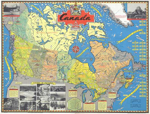
Canada.
sold
- Digital Map Information
- Suitable for large format printing
- File Size: 19.52 MB
- File Type: ZIP / TIFF
- ICC color profile embedded
- Delivered instantly via download link
This is a 1945 Stanley Francis Turner pictorial map of postwar Canada. The map depicts the region from the Pacific Ocean to the Greenland and the Atlantic Ocean and from the Arctic Ocean and Baffin Bay to the United States. Highly detailed, numerous ... (more details)
Labels the Pyramids and the Holy Land.

Nova Ægypti Tabula.
sold
- Digital Map Information
- Suitable for large format printing
- DPI: 300
- File Size: 4.31 MB
- File Type: ZIP / TIFF
- ICC color profile embedded
- Delivered instantly via download link
This is a 1686 Olfert Dapper map of Egypt and the western Middle East. Oriented towards the east, the map depicts the region from the Mediterranean Sea to Abyssinia, or approximately modern-day Ethiopia, and from the Arabian Peninsula past the Red ... (more details)
Napoleon would be exiled here almost 130 years later.

St. Helene.
sold
- Digital Map Information
- Suitable for large format printing
- DPI: 300
- File Size: 4.29 MB
- File Type: ZIP / TIFF
- ICC color profile embedded
- Delivered instantly via download link
This is a 1686 Olfert Dapper view of St. Helena. The view depicts the entirety of the island, illustrating its topography and rivers. Eight locations are numerically identified, with an index in Dutch in the lower left corner, and a French index ... (more details)
A visually striking map of Guangzhou, China.

Guangzhou Traffic Map
sold
- Digital Map Information
- Suitable for large format printing
- File Size: 5.56 MB
- File Type: ZIP / TIFF
- ICC color profile embedded
- Delivered instantly via download link
This is a 1959 city map or plan of Guangzhou / Canton, China. The map depicts central Guangzhou with the Zhujiang / Pearl River illustrated along the bottom of the city, along with the extreme northern portion of the Haizhu District. Myriad ... (more details)
The estate comes complete with a camp and a fly tying department.

Map of an Imaginary Estate for an Inveterate Fly-Fisherman.
sold
- Digital Map Information
- Suitable for large format printing
- File Size: 2.35 MB
- File Type: ZIP / TIFF
- ICC color profile embedded
- Delivered instantly via download link
This is a 1931 John Held, Jr. map of an imaginary estate for a fly-fisherman. The map depicts the estate, which is almost exclusively rivers and pools, an ideal setting for any fly-fisherman. A fish hatchery is situated in the upper right ... (more details)
One of the major ports on the Spanish Main for exporting Peruvian silver back to Spain.
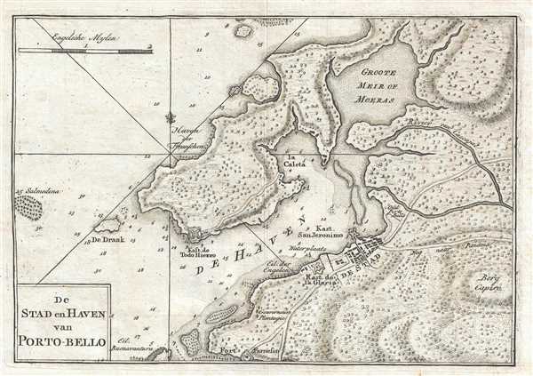
De Stad en Haven van Porto-Belo.
sold
- Digital Map Information
- Suitable for large format printing
- DPI: 300
- File Size: 2.14 MB
- File Type: ZIP / TIFF
- ICC color profile embedded
- Delivered instantly via download link
This is a 1765 Isaak Tirion map of Portobelo, Panama and its bay on the Spanish Main. The map depicts the town of Portobelo, Fort Gloria, and the immediate vicinity, including the harbor and Fort Todo Fierro, constructed across the harbor ... (more details)
Reveals Italy during its Risorgimento.

Southern Italy Kingdom of Naples, I. Sardinia and Malta.
sold
- Digital Map Information
- Suitable for large format printing
- File Size: 6.86 MB
- File Type: ZIP / TIFF
- ICC color profile embedded
- Delivered instantly via download link
This is an 1857 J.H. Colton map of southern Italy. Like most of Colton's Europe maps, this map was derived from an earlier wall map of the world produced by Colton and D. Griffing Johnson. The map depicts the southern part of the ... (more details)
Labels both Piscataway and Princeton.

Johnson's New Jersey.
sold
- Digital Map Information
- Suitable for large format printing
- File Size: 7.11 MB
- File Type: ZIP / TIFF
- ICC color profile embedded
- Delivered instantly via download link
This is an 1866 A. J. Johnson map of New Jersey. The map depicts the entire state along with portions of adjacent Delaware, Maryland, Pennsylvania, and New York. Counties are shaded various colors to allow for easy ... (more details)
A charming pictorial map of a boy scout camp - including a vignette of a T.-Rex.

Map of Camp Sunrise and Environs.
sold
- Digital Map Information
- Suitable for large format printing
- File Size: 3.28 MB
- File Type: ZIP / TIFF
- ICC color profile embedded
- Delivered instantly via download link
This is a 1940 Norm Adams pictorial map of Camp Sunrise boy scout camp in Vermont. The map depicts the camp from Doughty Pond and Perch Pond to Signal Point and from Rocky Point to Perch Pond and Watch Point. Sunset ... (more details)
Incredible map of these two states just after the Civil War.
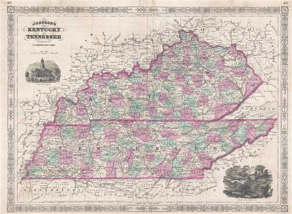
Johnson's Kentucky and Tennessee.
sold
- Digital Map Information
- Suitable for large format printing
- File Size: 15.09 MB
- File Type: ZIP / TIFF
- ICC color profile embedded
- Delivered instantly via download link
This is an 1866 A. J. Johnson map of Kentucky and Tennessee. Represents Johnson's third iteration of this map, which he updated in 1865 to reflect changes to these secessionist states following the American Civil ... (more details)
Depicts Christiania - how Oslo was known before 1925.

Johnson's Sweden and Norway. / Johnson's Denmark with Sleswick and Holstein.
sold
- Digital Map Information
- Suitable for large format printing
- File Size: 11.8 MB
- File Type: ZIP / TIFF
- ICC color profile embedded
- Delivered instantly via download link
This is an 1866 A. J. Johnson map of Norway, Sweden, and Demark. A composite on one folio sheet of two maps that were formerly issued on separate sheets, these maps depict Norway, Sweden, Denmark, and the German ... (more details)
Features an inset map of Panama City.

Johnson's Central America.
sold
- Digital Map Information
- Suitable for large format printing
- File Size: 8.5 MB
- File Type: ZIP / TIFF
- ICC color profile embedded
- Delivered instantly via download link
This is an 1866 A. J. Johnson map of the Central America and Jamaica. The map depicts from the Yucatan Peninsula to Panama and from the Pacific Ocean to Jamaica. Like most of Johnson's North America maps, ... (more details)
One year before the creation of Bismark's North German Confederation.
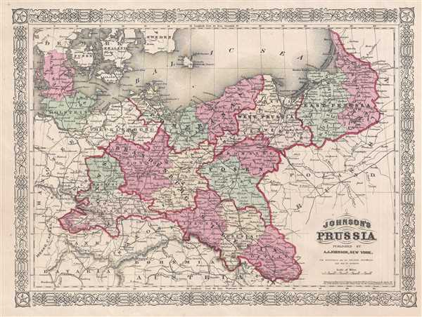
Johnson's Prussia.
sold
- Digital Map Information
- Suitable for large format printing
- File Size: 5.82 MB
- File Type: ZIP / TIFF
- ICC color profile embedded
- Delivered instantly via download link
This is an 1866 A.J. Johnson map of Prussia, Germany. The map depicts Prussia from Hanover and Brunswick to Poland and from the Baltic Sea to the Czech Republic (Bohemia / Austria), Bavaria, and Saxony. ... (more details)
The rare propaganda-ish 'Farm Animal' variant on the Visscher-Jansson Series map of New York, Virginia, and New England.

Novi Belgii Novaeque Angliae Nec Non Pennsylvaniae et Partis Virginiae Tabula multis in locis emendata.
sold
- Digital Map Information
- Suitable for large format printing
- DPI: 300
- File Size: 10.83 MB
- File Type: ZIP / TIFF
- ICC color profile embedded
- Delivered instantly via download link
A magnificent example of Justus Danckerts' 1690 Novi Belgii or map of New York, New England, Pennsylvania, and Virginia. Some call this the 'farm animal map' for its novel incorporation of farm animals, ... (more details)
A foundational map and the single most influential map of the the Pacific Northwest issued in the middle of the 18th Century.
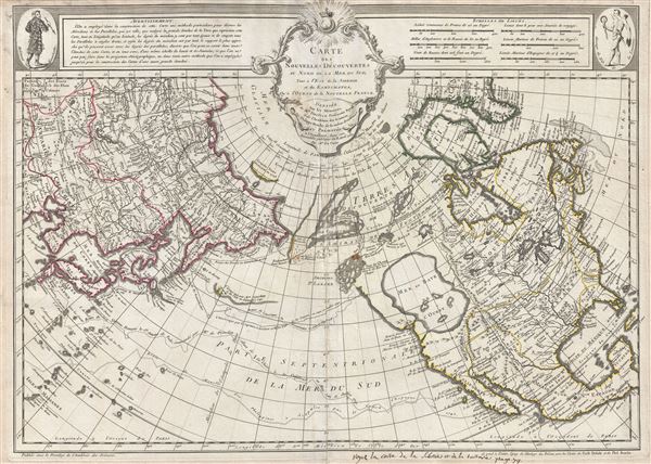
Carte Des Nouvelles Decouvertes au Nord de la Mer de Sud, tant a l'Est de la Syberie et du Kamtchatka, qu'a L'Ouest de la Nouvelle France.
sold
- Digital Map Information
- Suitable for large format printing
- DPI: 300
- File Size: 17.62 MB
- File Type: ZIP / TIFF
- ICC color profile embedded
- Delivered instantly via download link
Rare first edition of Joseph Nicolas De l'Isle's extraordinary 1752 map of North America, Siberia, the Arctic, and the North Pacific. J. N. De L'Isle and Buache drew this map to illustrate their ... (more details)
An exceptionally rare Japanese-Hawaiian map of Japanese friendly shops and business in 1906 Hawaii.

新撰布哇地圖 /一名布哇案內 / Newly Compiled Map of Hawaii.
sold
- Digital Map Information
- Suitable for large format printing
- Full resolution TIFF file
- ICC color profile embedded
- Delivered instantly via download link
An extremely rare 1906 (Meiji 39) Hawaii shopping guide printed in Hawaii by Japanese-Hawaiian Takei Nekketsu. The map details the five major islands (Hawaii, Maui, Oahu, and Kauai) separately in addition to providing a general overview of the Hawaiian Archipelago. The map proper is surrounded by advertisements for Japanese friendly business ranging from restaurants, to hatters, to hospitals, to bicycle shops.
This map is part of a genre of maps printed in the late 19th and early 20th century by Japanese immigrants. They are typically predominantly or exclusively printed in Japanese and were intended for use by local Japanese-Hawaiians or their friends and relatives visiting from Japan.
This map is accompanied by its highly attractive original binder with two maps on a globular projection. The top map illustrates east Asia and the bottom, Shows Hawaii with an apparent focus on Molokai, which is enlarged. The overall design of the map suggests friendship and cooperation between Japan and America, with numerous images of entwined Japanese and American flags. (more details)
This map is part of a genre of maps printed in the late 19th and early 20th century by Japanese immigrants. They are typically predominantly or exclusively printed in Japanese and were intended for use by local Japanese-Hawaiians or their friends and relatives visiting from Japan.
This map is accompanied by its highly attractive original binder with two maps on a globular projection. The top map illustrates east Asia and the bottom, Shows Hawaii with an apparent focus on Molokai, which is enlarged. The overall design of the map suggests friendship and cooperation between Japan and America, with numerous images of entwined Japanese and American flags. (more details)