
Important map illustrating Mexico and Texas just before the 1848 Treaty of Guadeloupe-Hidalgo. Texas at its fullest with stovepipe configuration.

Map of Mexico, including Yucatan and Upper California, exhibiting the Chief Cities and Towns, The Principal Travelling Routes and c.
sold
- Digital Map Information
- Suitable for large format printing
- DPI: 300
- File Size: 13.99 MB
- File Type: ZIP / TIFF
- ICC color profile embedded
- Delivered instantly via download link
This is Samuel Augustus Mitchell's important 1847 map of Texas at its fullest, Mexico, and Upper California. This is one of the most important and striking maps issued to illustrate the Mexican American War. Centered on Texas, Mitchell's map covers from 42°N to ... (more details)
First edition of one of the earliest Revolutionary War Era maps to recognize the fledgling United States.
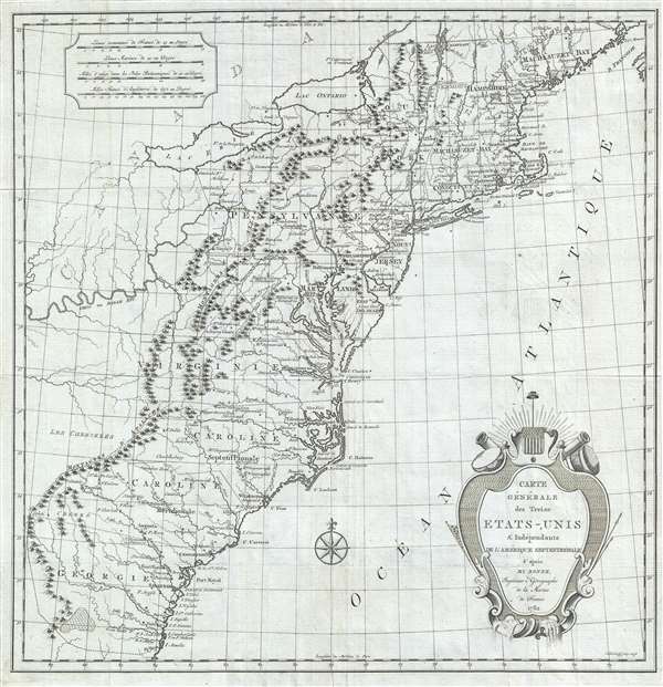
Carte Générale des Treize États-Unis et Indépendants de l'Amérique Septentrionale.
sold
- Digital Map Information
- Suitable for large format printing
- DPI: 300
- File Size: 7.57 MB
- File Type: ZIP / TIFF
- ICC color profile embedded
- Delivered instantly via download link
This is the scarce first edition of Hendrik Klockhoff's 1782 map of United States. Issued at the tail end of the American Revolutionary War (1775 - 1883), this is one of the earliest obtainable maps to name the United States, in this case Etats-Unis . Derived ... (more details)
No amount of time spent on this map would be wasted; its detail is fascinating. - Wheat

Map of the States of California and Nevada. Carefully Compiled from the Latest Authentic Sources. By Chas. Drayton Gibbes, C.E.
sold
- Digital Map Information
- Suitable for large format printing
- File Size: 44.84 MB
- File Type: ZIP / TIFF
- ICC color profile embedded
- Delivered instantly via download link
A beautiful and rare variant on the first edition second state of Warren Holt and Charles Drayton Gibbes' 1873 map of California and Nevada, considered to be one of the finest large-scale maps of California to appear in the second half of the 19th century. The ... (more details)
Interesting allegorical investment map.
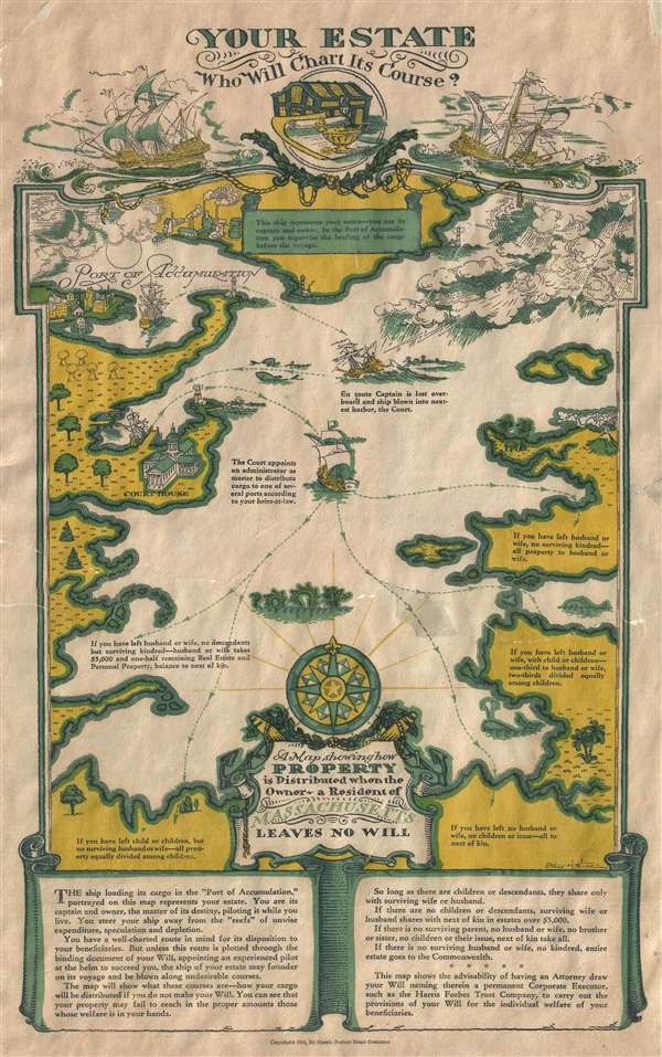
Your Estate Who Will Chart Its Course. / A Map Showing How Property is Distributed when the Owners - a Resident of Massachusetts Leaves no Will.
sold
- Digital Map Information
- Suitable for large format printing
- File Size: 6.34 MB
- File Type: ZIP / TIFF
- ICC color profile embedded
- Delivered instantly via download link
This charming 1930 map is an allegorical map of estate planning in Massachusetts. Drawn by illustrator Stacy H. Wood, the map analogized the fates of one's estate after death to a voyage. The fateful 'estate ship' starts its journey at the Port of ... (more details)
The earliest obtainable map or plan of New Orleans, Louisiana.

Plan de la Nouvelle Orleans. Sur les Manuscrits du Depôt des Cartes de la Marine.
sold
- Digital Map Information
- Suitable for large format printing
- Full resolution TIFF file
- ICC color profile embedded
- Delivered instantly via download link
This scarce 1744 map by J. N. Bellin is the earliest obtainable map of New Orleans, Louisiana. Oriented to the northwest, Bellin's map covers the original settlement of New Orleans along the Mississippi River and inland as far the Fosse plein d'eau ... (more details)
Rare map of Shanghai illustrating early development of Yangpu District.
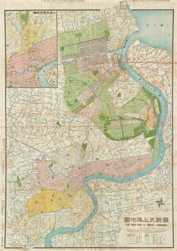
最新大上海地圖 / The New Map of Great Shanghai. / Saishin dai Shanhai chizu.
sold
- Digital Map Information
- Suitable for large format printing
- File Size: 31.12 MB
- File Type: ZIP / TIFF
- ICC color profile embedded
- Delivered instantly via download link
This is a scarce 1940 Shōwa 15 Fusazō Sugie Japanese issue map of Shanghai, China. The map follows the course of the Hunagpu River from Baoshan and its convergence with the Yangtze south to, roughly, Dama Jiazhai. Color coding emphasized the ... (more details)
Rare map of Beijing prepared at the beginning of the Peip'ing (北平) period.

最新詳密 北京城內全圖 / The Latest Beijing City Map.
sold
- Digital Map Information
- Suitable for large format printing
- File Size: 13.51 MB
- File Type: ZIP / TIFF
- ICC color profile embedded
- Delivered instantly via download link
A scarce map of Beijing or Peking, China, issued in October of 1929 or Showa 4. The map details the inner and outer cities as well as the Forbidden City and the Legation Quarter. The map was drawn b the Japanese military cartographer Kizaki ... (more details)
Japanese issue military topographical map of Taipei.

臺北近傍圖 / Taipei Vicinity.
sold
- Digital Map Information
- Suitable for large format printing
- File Size: 23.68 MB
- File Type: ZIP / TIFF
- ICC color profile embedded
- Delivered instantly via download link
An undated, but probably about 1925, topographical map of northern Taiwan in the vicinity of Taipei – which appears prominently. Individual streets and buildings are identifiable. The map also illustrates roads, railroads, topography, ... (more details)
Incredible pictorial propaganda map promoting American, British, and Canadian tourism in Nazi Germany.
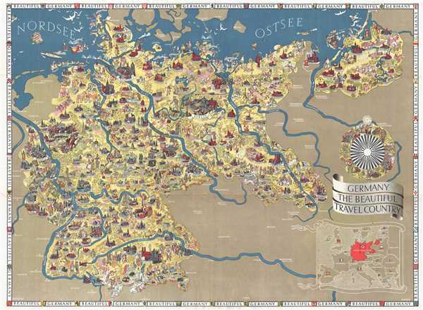
Germany, The Beautiful Travel Country.
sold
- Digital Map Information
- Suitable for large format printing
- File Size: 21.57 MB
- File Type: ZIP / TIFF
- ICC color profile embedded
- Delivered instantly via download link
This is a 1938 Walter Riemer pictorial propaganda / tourist map of Nazi Germany. The map depicts Germany from its western border with France, Luxembourg, Belgium, and the Netherlands to its eastern border with Poland and from the North ... (more details)
A pictorial overview of Mexican life, history, and culture from the most prominent Mexican pictorial map artist!
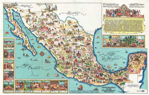
Pictorial Map of Mexico.
sold
- Digital Map Information
- Suitable for large format printing
- Full resolution TIFF file
- ICC color profile embedded
- Delivered instantly via download link
This is a 1931 Miguel Gomez Medina pictorial map of Mexico. The map depicts all of Mexico from the southern United States (labeling Arizona, New Mexico, and Texas) to the Belize, Guatemala, and the Pacific Ocean and from the Pacific ... (more details)
Enormous visually arresting map of the United States with elaborate typographic title.
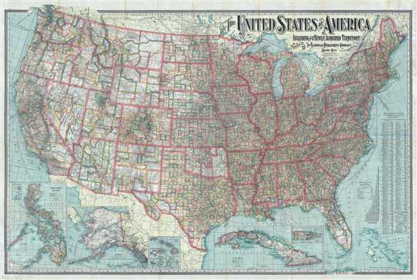
The United States of America Including All Its Newly Acquired Territory.
sold
- Digital Map Information
- Suitable for large format printing
- File Size: 76.42 MB
- File Type: ZIP / TIFF
- ICC color profile embedded
- Delivered instantly via download link
This is a 1902 National Publishing Company map of the United States with an elaborate typograpical title. The map depicts the continental United States from the Pacific Ocean to the Atlantic Ocean and the Bahamas and from Canada to ... (more details)
Beautiful map charts the entire coast of the United States, including the Atlantic Coast, the Gulf Coast and the Pacific Coast.
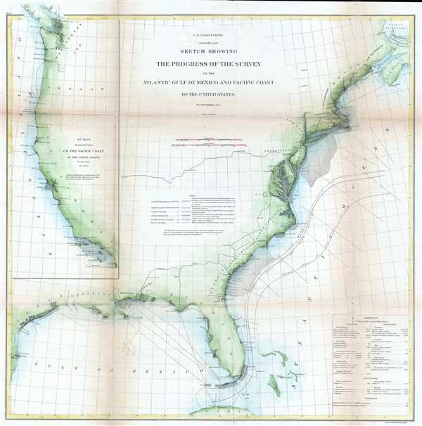
Sketch Showing the Progress of the Survey on the Atlantic Gulf of Mexico and Pacific Coast of the United States.
sold
- Digital Map Information
- Suitable for large format printing
- File Size: 8.61 MB
- File Type: ZIP / TIFF
- ICC color profile embedded
- Delivered instantly via download link
This is a beautiful 1860 U.S. Coast Survey nautical chart or maritime map of the coast of the United States. The map depicts the Atlantic Coast, the Gulf Coast and the Pacific Coast in beautiful detail. Divided into two sections, ... (more details)
Scarce early map of Santa Barbara and Los Angeles California.

(J No. 4) Preliminary Survey of San Pedro Anchorage and Vicinity of Santa Barbara California.
sold
- Digital Map Information
- Suitable for large format printing
- File Size: 1.86 MB
- File Type: ZIP / TIFF
- ICC color profile embedded
- Delivered instantly via download link
An uncommon example of the 1859 U.S. Coast Survey nautical chart or maritime map of Santa Barbara and San Pedro (Los Angeles), California. Essentially two maps on a single sheet, the left hand map details the stretch of land ... (more details)
Rare Civil War map with remarkable abolitionist provenance.
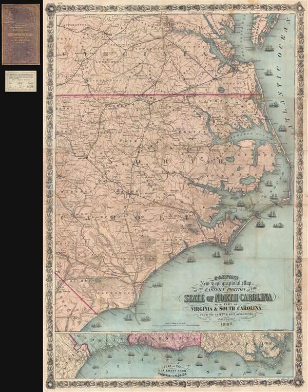
Colton's New Topographical Map of the Eastern Portion of the State of North Carolina with Part of Virginia and South Carolina from the latest and best authorities.
sold
- Digital Map Information
- Suitable for large format printing
- File Size: 29.25 MB
- File Type: ZIP / TIFF
- ICC color profile embedded
- Delivered instantly via download link
This is an impressive large scale 1863 J. H. Colton map of the eastern part of North Carolina during the American Civil War. It is from the library of Union Brigadier General Edward Augustus Wild, the abolitionist leader of ... (more details)
Aims to promote tourism among the emerging African-American middle class.

Afro American Travel Map.
sold
- Digital Map Information
- Suitable for large format printing
- File Size: 5 MB
- File Type: ZIP / TIFF
- ICC color profile embedded
- Delivered instantly via download link
This is a 1942 Afro American Newspapers map of the eastern United States meant to promote tourism among the emerging African-American middle class. The map depicts the United States from the Mississippi River to the Atlantic ... (more details)
Stunning pictorial map of China during the Boxer Rebellion.
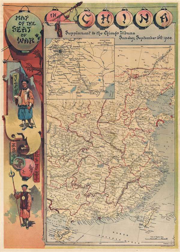
Map of the Seat of War in China. Supplement to the Chicago Tribune, Sunday, Septemer 16th 1900.
sold
- Digital Map Information
- Suitable for large format printing
- File Size: 9.27 MB
- File Type: ZIP / TIFF
- ICC color profile embedded
- Delivered instantly via download link
This is a rare chromolithograph pictorial map of China issued by the Chicago Tribune on Sunday, September 16, 1900, to illustrate the events of the Boxer Rebellion or Yihetuan Movement. The map details China from Hainan to ... (more details)
Depicts where French troops were stationed following the supression of the Boxer Rebellion!
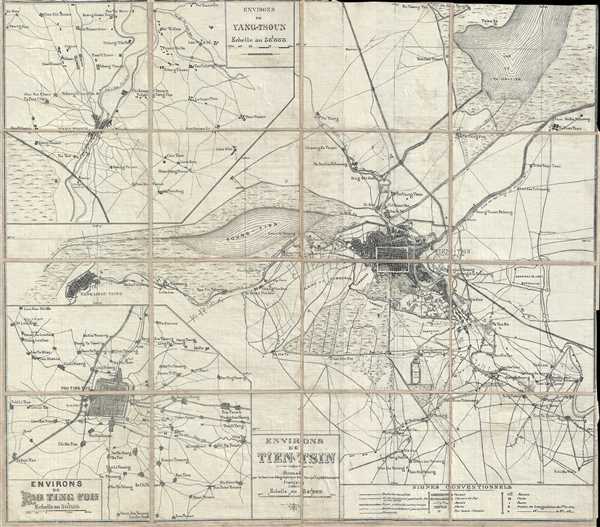
Envrions de Tien-Tsin.
sold
- Digital Map Information
- Suitable for large format printing
- File Size: 11.6 MB
- File Type: ZIP / TIFF
- ICC color profile embedded
- Delivered instantly via download link
This is a 1901 French Service Géographique (Geographic Service) map of the region around Tianjin (Tientsin), China, during the Boxer Rebellion, particularly illustrating the region of deployment of the French Expeditionary ... (more details)
Early mapping of Florida and California as peninsulas and large iteration of Verrazano's Sea. America is connected to Asia!
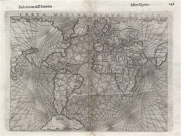
Carta Marina Nuova Tavola.
sold
- Digital Map Information
- Suitable for large format printing
- DPI: 300
- File Size: 3.26 MB
- File Type: ZIP / TIFF
- ICC color profile embedded
- Delivered instantly via download link
A nice example of Girolamo Ruscelli's 1561 Carta Marina maritime map of the world. This is one of two 'modern' maps accompanying the Vincenzo Valgrisi / Ruscelli Venice edition of Ptolemy's Geographica . Cartographically ... (more details)
Important map illustrating American Indian land assignments west of the Mississippi in 1834.
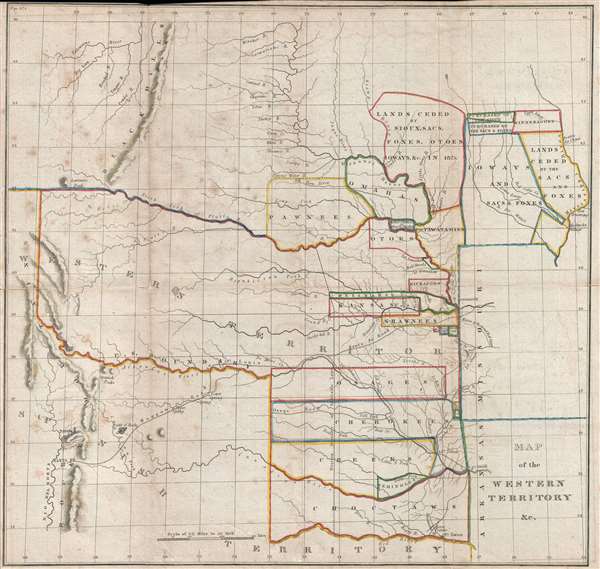
Map of the Western Territory and c.
sold
- Digital Map Information
- Suitable for large format printing
- Full resolution TIFF file
- ICC color profile embedded
- Delivered instantly via download link
A trans-Mississippi map of considerable interest and historical importance, this is Washington Hood's 1834 map of American Indian lands in modern day Oklahoma, Kansas, Nebraska, and Iowa (although coverage extends to ... (more details)
An early map depicting the four fictional islands in Lake Superior which were later used to draw post-Revolutionary War US-Canada border.
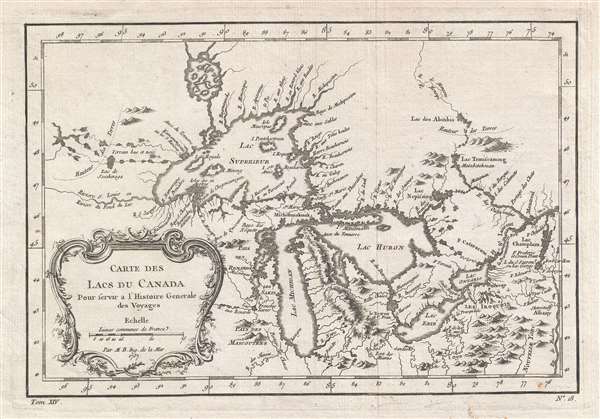
Carte des Lacs du Canada.
sold
- Digital Map Information
- Suitable for large format printing
- Full resolution TIFF file
- ICC color profile embedded
- Delivered instantly via download link
This is an important 1757 map by French cartographer Jacques-Nicholas Bellin of the Great Lakes. It covers all five of the Great Lakes as well as the adjacent Indian lands and the English colonies of Pennsylvania, ... (more details)