
Unusual map illustrating the discoveries of Russian fur traders in the Aleutian Islands after Bering's expedition but before Cook.
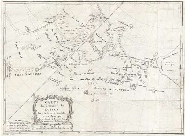
Carte des Découverts des Russes dans la Mer Orientale, et en Amerique Pour Servir à L'essai, Sur le commerce de Russie.
sold
- Digital Map Information
- Suitable for large format printing
- DPI: 300
- File Size: 9.14 MB
- File Type: ZIP / TIFF
- ICC color profile embedded
- Delivered instantly via download link
This is a rare and unusual 1777 map of the north Pacific in the vicinity of Alaska, the Bering Straits, and northeastern Siberia based upon Russian Promyshlenniki (trader) exploration. The map post-dates Russian state sponsored Vitus Bering Great Northern ... (more details)
Beautifully colored map of Poland - with views of Krakow and Breslau!
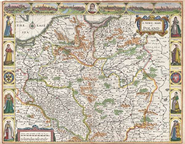
A Newe Mape of Poland.
sold
- Digital Map Information
- Suitable for large format printing
- DPI: 300
- File Size: 11.83 MB
- File Type: ZIP / TIFF
- ICC color profile embedded
- Delivered instantly via download link
This is a 1676 John Speed carte-a-figure map of Poland issued at the end of the Second Polish-Ottoman War. The map depicts from the Baltic Sea and eastern Bohemia to Prussia, Lithuania, and western Russia and from the Baltic to Kraków (Cracow; Cracovia). ... (more details)
Rare World War II Japanese map of the Philippines.
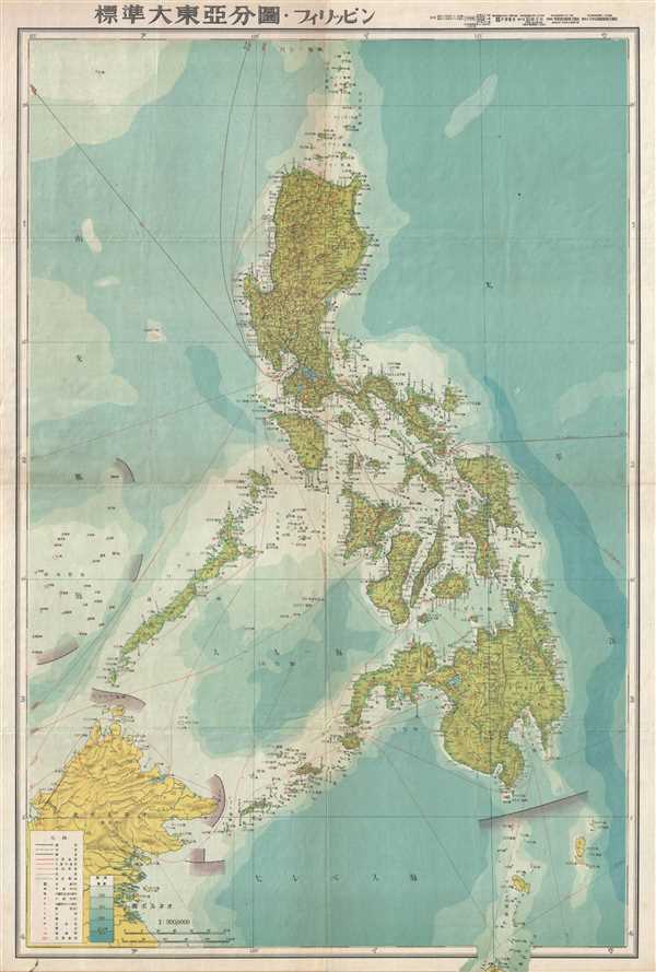
標準大東亞分圖 : フィリッピン / Standard Map of the Great East Asia: Philippines.
sold
- Digital Map Information
- Suitable for large format printing
- File Size: 10.39 MB
- File Type: ZIP / TIFF
- ICC color profile embedded
- Delivered instantly via download link
An important and rare World War II (WWII) 1943 Japanese map of the Philippines. The map covers the Philippine Islands from the small islands north of the Luzon to North Maluku, which appears just outside the printed border, and from northern Borneo to ... (more details)
Unusual elongated map of Manhattan Island.

Map of the City of New York.
sold
- Digital Map Information
- Suitable for large format printing
- File Size: 9.98 MB
- File Type: ZIP / TIFF
- ICC color profile embedded
- Delivered instantly via download link
This is an unusual and very rare 1868 Map of New York city by William C. Rogers. The map depicts the whole of the island of Manhattan with some detail in parts of Brooklyn, Queens and the Bronx. This unusual map offers extraordinary detail throughout ... (more details)
Gorgeous map with fantastic illustrations of animals!

Recreational Map San Diego Zoo.
sold
- Digital Map Information
- Suitable for large format printing
- File Size: 23.5 MB
- File Type: ZIP / TIFF
- ICC color profile embedded
- Delivered instantly via download link
This is a 1950 R. W. Schultheis pictorial map of the San Diego Zoo. The striking cartoon was drawn to serve as a cheerful guide to the zoo. Numerous species of animals are illustrated, including monkeys, flamingoes, tortoises, herons, giraffes, ... (more details)
Early view of an important Spanish port city in the Basque Region.

Santander.
sold
- Digital Map Information
- Suitable for large format printing
- DPI: 300
- File Size: 8.63 MB
- File Type: ZIP / TIFF
- ICC color profile embedded
- Delivered instantly via download link
This is a 1580 Georg Braun and Franz Hogenberg view of Santander, Spain. The view overlooks the town of Santander from one of the hills which presumably surrounds the city. The city and harbor are depicted in detail, illustrating individual ... (more details)
Attractive detailed map of New England featuring the region's railroad network!

Johnson's Vermont, New Hampshire, Massachusetts, Rhode Island, and Connecticut.
sold
- Digital Map Information
- Suitable for large format printing
- File Size: 10.29 MB
- File Type: ZIP / TIFF
- ICC color profile embedded
- Delivered instantly via download link
This is a beautiful example of Johnson and Ward's 1865 map of New England. The map depicts the New England from Long Island to Maine and from the Hudson Valley to the Atlantic Seabord. Numerous cities, towns, and townships are labeled, ... (more details)
Illustrates English, French, and Spanish possessions in the modern-day United States.
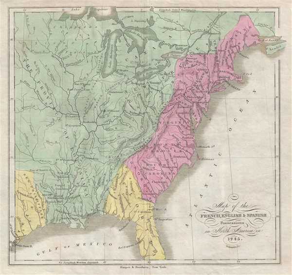
Map of the French, English, and Spanish Possessions in North America in 1745.
sold
- Digital Map Information
- Suitable for large format printing
- DPI: 300
- File Size: 1.64 MB
- File Type: ZIP / TIFF
- ICC color profile embedded
- Delivered instantly via download link
This is an 1846 William Kemble map of the colonial United States. The map depicts the United States from the Missouri River to the Atlantic Ocean and Acadia and from Lake Superior to the Gulf of Mexico. The colonial possessions of the ... (more details)
The Yazoo and Mississippi Valley Railroad are featured in several songs by legendary blues masters.
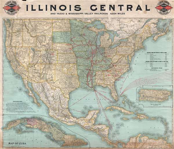
Illinois Central and Yazoo and Mississippi Valley Railroads. 4,824 miles.
sold
- Digital Map Information
- Suitable for large format printing
- File Size: 33.22 MB
- File Type: ZIP / TIFF
- ICC color profile embedded
- Delivered instantly via download link
This is an 1897 Poole Brothers railroad map of the Illinois Central and Yazoo and Mississippi Valley railroads. The map depicts the continental United States from the Pacific Ocean to the Atlantic Ocean and from the Canada to Mexico, ... (more details)
Rare topographic map of Seoul on a large scale prepared in 1916.
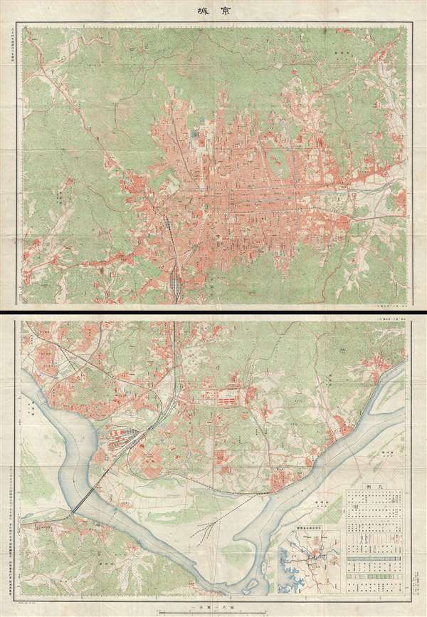
京城 / Capital.
sold
- Digital Map Information
- Suitable for large format printing
- File Size: 44.96 MB
- File Type: ZIP / TIFF
- ICC color profile embedded
- Delivered instantly via download link
Titled simply 'Capital' (京城), this is a detailed two-part map of Seoul, South Korea, prepared in 1916 (Taisho 5), following the Japanese Annexation. The map is impressive in both its size and detail, extending from the ... (more details)
A map from the first Western atlas of China created by the 'first to study the history and geography of China with rigorous scientific objectivity.'
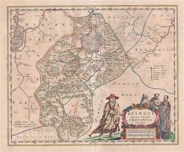
Kiangsi, Imperii Sinarum Provincia Octava.
sold
- Digital Map Information
- Suitable for large format printing
- DPI: 300
- File Size: 10.98 MB
- File Type: ZIP / TIFF
- ICC color profile embedded
- Delivered instantly via download link
This is a 1655 Martino Martini and Joan Blaeu map of Jiangxi (Kiangsi) Province in China. The map depicts the region from the Yangtze River and Poyang Lake to Guangdong (Quantung) Province and from Hunan (Huquang) Province ... (more details)
A 18th century map guide to English Privateering in the West Indies.
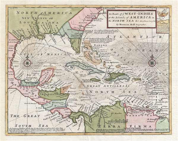
A Chart of ye West-Indies or the Islands of the Americas in the North Sea and c. Being ye Present Seat of War.
sold
- Digital Map Information
- Suitable for large format printing
- Full resolution TIFF file
- ICC color profile embedded
- Delivered instantly via download link
Drawn at the tail end of the Golden Age of Caribbean Piracy, this is a stunning posthumous example of Herman Moll's important map of the West Indies, revised in 1745 to illustrate the War of Jenkins' Ear ( Guerra del ... (more details)
Very rare Italian edition of Bellin's map of the Chesapeake Bay region.
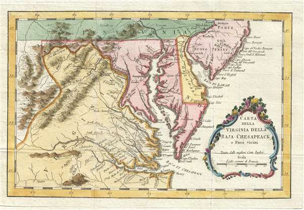
Carta della Virginia della Baja Chesapeack e Paesi vicini.
sold
- Digital Map Information
- Suitable for large format printing
- DPI: 300
- File Size: 2.72 MB
- File Type: ZIP / TIFF
- ICC color profile embedded
- Delivered instantly via download link
This is a rare 1781 Italian edition of French cartographer Jacques-Nicholas Bellin’s 1757 map of the Chesapeake Bay including Virginia, Maryland, Delaware and parts of New Jersey and Pennsylvania. Bellin's map ... (more details)
Stunning view of a battle between the Dutch and the Portuguese in Brazil!
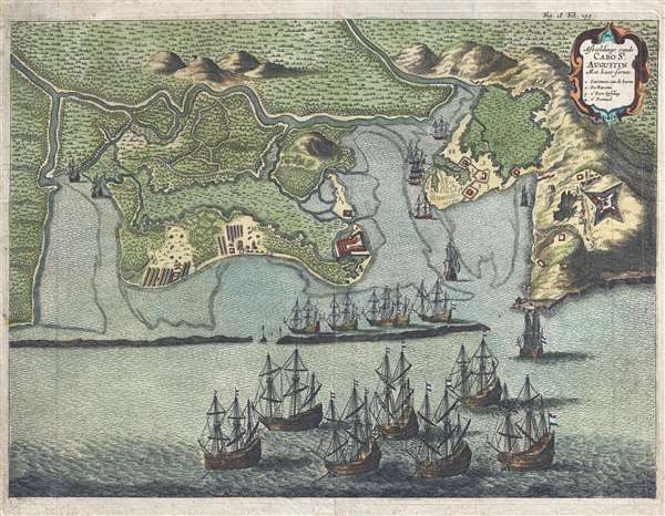
Afbeeldinge van de Cabo St. Augustin: Met haer forten.
sold
- Digital Map Information
- Suitable for large format printing
- DPI: 300
- File Size: 5.55 MB
- File Type: ZIP / TIFF
- ICC color profile embedded
- Delivered instantly via download link
This is a rare 1656 Jan Jansson and Isaac Commelin view of Cabo de Santo Agostinho, Brazil illustrating a battle between the Dutch and the Portuguese. The view depicts Cabo de Santo Agostihno from the east. ... (more details)
Labels individual farmsteads and plantations!
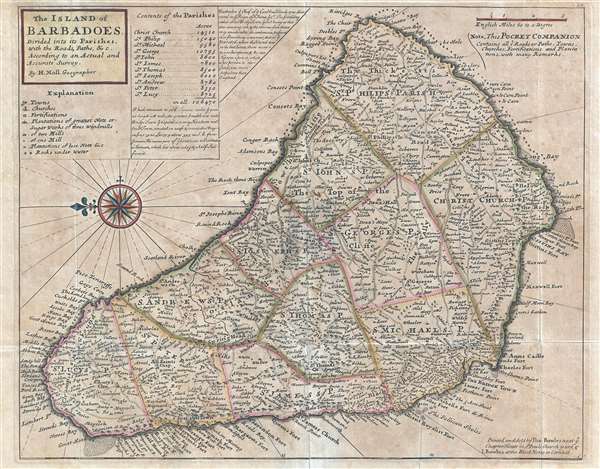
The Island of Barbadoes. Divided into its Parishes, with the Roads, Paths, etc. According to an Actual and Accurate Survey.
sold
- Digital Map Information
- Suitable for large format printing
- DPI: 300
- File Size: 4.8 MB
- File Type: ZIP / TIFF
- ICC color profile embedded
- Delivered instantly via download link
This is a 1736 Herman Moll map of the island of Barbados. The map depicts the entire island with north oriented to the left. The island is divided into eleven parishes. Myriad locations are labeled all over ... (more details)
One of the first maps to name Acadia National Park.

Map of Mount Desert Island Maine Showing Acadia National Park.
sold
- Digital Map Information
- Suitable for large format printing
- File Size: 66.74 MB
- File Type: ZIP / TIFF
- ICC color profile embedded
- Delivered instantly via download link
This is a 1929 H. Duane Higgins map of Mount Desert Island, Maine, including the newly renamed Acadia National Park. The map depicts Mount Desert Island from Trenton, Maine, the Jordan River, and Frenchman ... (more details)
One year after the incorporation of the Newburyport Y.M.C.A, which is labeled!

City of Newburyport.
sold
- Digital Map Information
- Suitable for large format printing
- File Size: 8.27 MB
- File Type: ZIP / TIFF
- ICC color profile embedded
- Delivered instantly via download link
This is a George H. Walker and Company 1891 city map or plan of Newburyport, Massachusetts. The map depicts the city of Newburyport from Salisbury and across the Merrimack River to the city line and from ... (more details)
Remarkable early French map of Singapore representing the forefront of scientific mapping of the region I the 1840s.
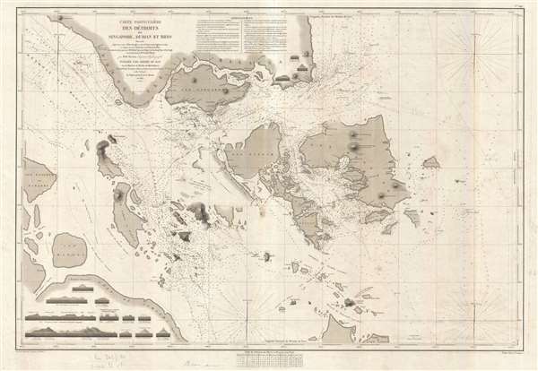
Carte Particulière des Détroits de Singapore, Durian et Rhio.
sold
- Digital Map Information
- Suitable for large format printing
- DPI: 300
- File Size: 22 MB
- File Type: ZIP / TIFF
- ICC color profile embedded
- Delivered instantly via download link
An exceptionally rare nautical chart of Singapore and vicinity issued by Urban Dortet de Tessan, under the patronage of Louis Philippe I of France. French nautical charts of the Singapore region have ... (more details)
Rare city plan of Singapore printed in Singapore.

Singapore.
sold
- Digital Map Information
- Suitable for large format printing
- File Size: 6.58 MB
- File Type: ZIP / TIFF
- ICC color profile embedded
- Delivered instantly via download link
This uncommon highly detailed map of Singapore city was issued in 1933 by Printers LTD of Singapore. Centered on the Downtown Core, the map covers what is today central Singapore from, roughly the ... (more details)
Detailed map of Penang or George Town, Malaysia.

George Town (Penang).
sold
- Digital Map Information
- Suitable for large format printing
- File Size: 4.12 MB
- File Type: ZIP / TIFF
- ICC color profile embedded
- Delivered instantly via download link
A very uncommon 1933 map of George Town or Penang, Malaysia issued in Singapore by Printers Limited. The map focuses on the peninsula of George Town east of Scotland Road (Jalan Scotland). ... (more details)