
Striking view of the Battle of Manila Bay during the Spanish-American War.

Battle of Manila, May 1.
sold
- Digital Map Information
- Suitable for large format printing
- Full resolution TIFF file
- ICC color profile embedded
- Delivered instantly via download link
This is an 1898 James Gale Tyler chromolithograph view of the Battle of Manila Bay, which took place on May 1, 1898. The battle, between the American Asiatic Squadron under Commodore George Dewey and the Spanish Pacific Squadron under Admiral Patricio Montojo, was ... (more details)
Spanish-American War map of Manila.
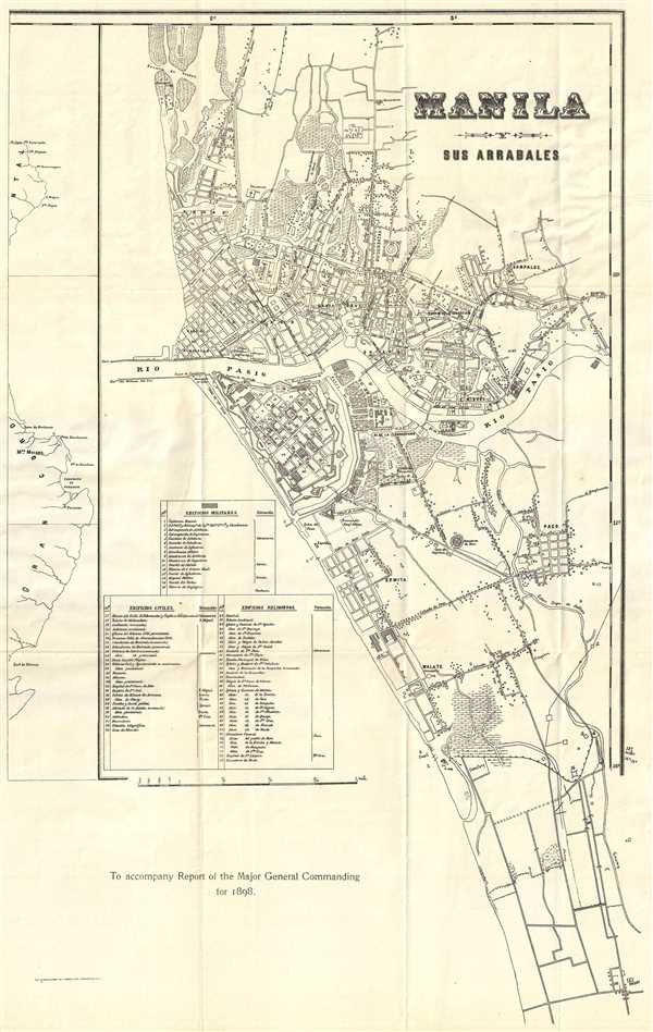
Manila y Sus Arrabales. To accompany Report of Major General Commanding for 1898.
sold
- Digital Map Information
- Suitable for large format printing
- File Size: 5.08 MB
- File Type: ZIP / TIFF
- ICC color profile embedded
- Delivered instantly via download link
This is an 1898 Norris Peters edition of a Francisco J. de Gamoneda map or city plan of Manila, the Philippines and was printed to accompany the report of the Major General commanding in the Philippines, who was also the military governor. The map depicts the city from the Barrio de S. Nicolas to Pasay and from the Bocana de Vistas to Pasay. The Pasig River divides the city in two, just as it does today. Highly detailed, roads, neighborhoods and civic sites, such as cemeteries, are labeled. There is an index along the left margin which lists seventy-seven military, civil, and religious sites around the city. (more details)
Rare advertising broadsheet issued to capitalize on interest in the Second Italian War of Independence.

The Seat of War Lombardy and Venice, Sardinia, Tuscany, Parma, Modena, Lucca, and the States of the Church, 1859. / Colton's Northern Italy. / Colton's Europe.
sold
- Digital Map Information
- Suitable for large format printing
- File Size: 15.03 MB
- File Type: ZIP / TIFF
- ICC color profile embedded
- Delivered instantly via download link
This is a rare separately issued 1859 appropriation of Colton's c. 1855 maps of Italy and Europe to promote the interests of the John W. Quincy hardware and ironworks company. This map was issued in 1859 to capitalize on general interest in the Second Italian War ... (more details)
A rare view of Cape Cod, Long Island, Boston and New York illustrating the Joy steamship line.
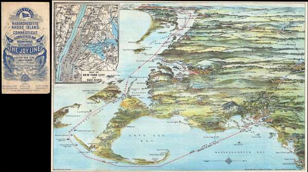
Birds eye view of Massachusetts, Rhode Island and Connecticut. A comprehensive map of the waterways traversed by steamers of the Joy Line between Boston-New York, Providence, with table of distances.
sold
- Digital Map Information
- Suitable for large format printing
- File Size: 12.7 MB
- File Type: ZIP / TIFF
- ICC color profile embedded
- Delivered instantly via download link
This unusual 1905 chromolithograph bird's-eye view of Cape Cod, New York, and Long Island, was issued by George H. Walker to promote the Joy Line. The Joy Line was a regular steamship ferry services connecting Boston, Massachusetts; Providence, Rhode Island; and ... (more details)
An unusual late-1950s paper globe from Spain.

[Globe].
sold
An unusual 1957 Spanish paper tabletop standing globe, the map depicts the Earth in four different quarters. Each side of the globe displays a different part of the Earth overlapping slightly with the sections to its left and right. Along the paper stand, flags ... (more details)
Scarce French map of the Carolina colonies during the American Revolutionary War.
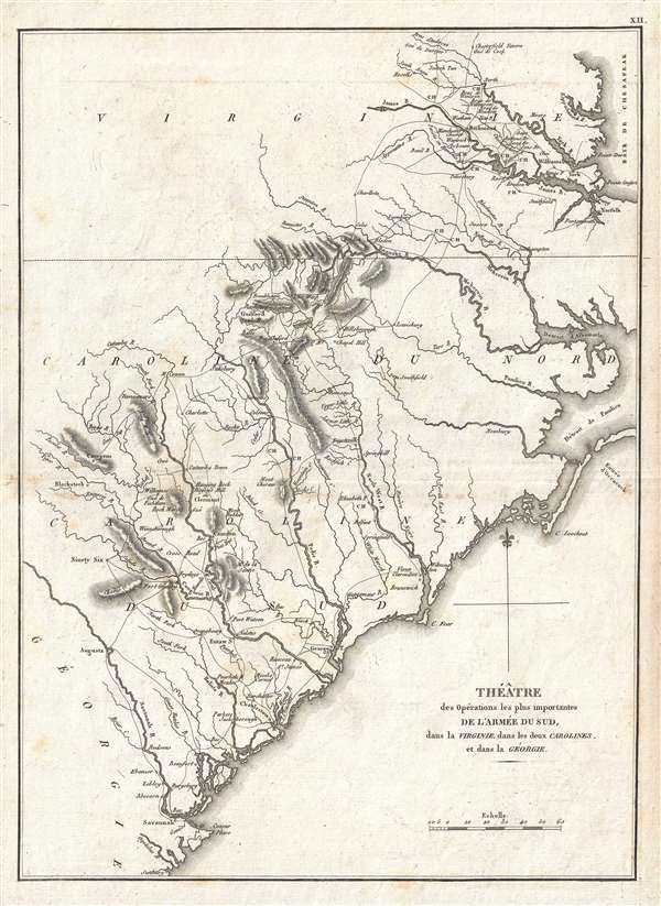
Théâtre des opérations les plus importantes de l'armée du sud, dans la Virginie, dans les deux Carolines, et dans la Géorgie.
sold
- Digital Map Information
- Suitable for large format printing
- Full resolution TIFF file
- ICC color profile embedded
- Delivered instantly via download link
A scarce example of the 1807 map of North Carolina, South Carolina, and Virginia during the Revolutionary War issued for the 1802 French edition of John Marshall's 1832 Life of Washington . The map covers from the Chesapeake Bay and Richmond, Virginia ... (more details)
Incredible 1900 city map or plan of New York City.
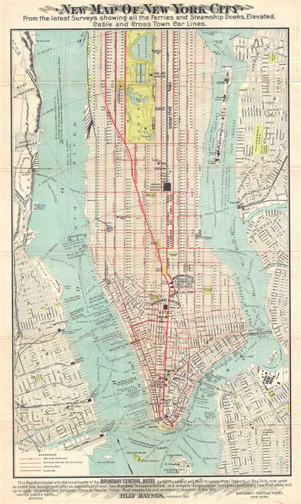
New Map of New York City. From the latest Surveys showing all the Ferries and Steamship Docks, Elevated, Cable and Cross Town Car Lines.
sold
- Digital Map Information
- Suitable for large format printing
- File Size: 7.48 MB
- File Type: ZIP / TIFF
- ICC color profile embedded
- Delivered instantly via download link
This is a 1900 Broadway Central Hotel map or guide of New York City. The map depicts Manhattan from Battery Park to 96th Street, as well as parts of New Jersey, Brooklyn, and Queens. The map details ferry and rail lines in and out of Manhattan, as well ... (more details)
Rare pictorial map of Jamestown, Rhode Island illustrating the regional events of the American Revolutionary War.

Ye Olde Map of James Towne or Quononoqutt Island.
sold
- Digital Map Information
- Suitable for large format printing
- File Size: 11.13 MB
- File Type: ZIP / TIFF
- ICC color profile embedded
- Delivered instantly via download link
A rare example of a rare 1928 S.C. King Jr. map of colonial Jamestown, Rhode Island. The map depicts Conanicut (Quononoqutt) Island where the settlement of Jamestown was established in 1678, named after James, Duke of York, who would later become King ... (more details)
Iconic pictorial map of Long Island, New York.

A Map of Long Island.
sold
- Digital Map Information
- Suitable for large format printing
- File Size: 13.55 MB
- File Type: ZIP / TIFF
- ICC color profile embedded
- Delivered instantly via download link
This is a charming 1961 pictorial map of Long Island by Courtland Smith. This historical map covers from New London in Connecticut and Fishers Island south as far as the Lower New York Bay and Staten Island. Long Island is depicted in its entirety ... (more details)
Blake geological map of one of the proposed routes for the Pacific Railroad.
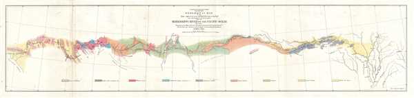
Geological Map of the Route Explored by Lieut. A. W. Whipple, Corps of Topographical Engineers near the parallel of 35 degrees North Latitude from the Mississippi River to the Pacific Ocean. 1853-1854.
sold
- Digital Map Information
- Suitable for large format printing
- DPI: 300
- File Size: 4.04 MB
- File Type: ZIP / TIFF
- ICC color profile embedded
- Delivered instantly via download link
This is an 1854 William Phipps Blake geological map of the American West prepared for the War Department's Pacific Railroad explorations and surveys. The map depicts the western United States from Memphis, Tennessee and the Mississippi River west ... (more details)
Map depicting the commuting time from City Hall, in New York, to New Jersey and Brooklyn.
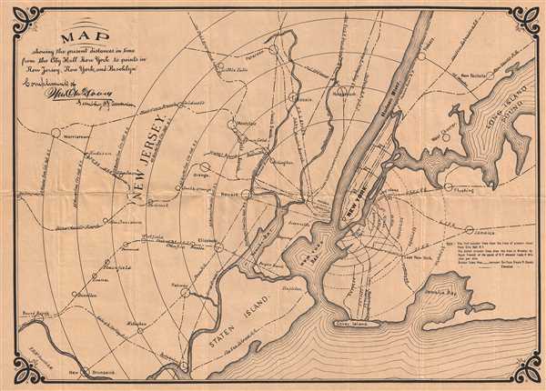
Map showing the present distances in time from the City Hall New York to points in New Jersey, New York, and Brooklyn.
sold
- Digital Map Information
- Suitable for large format printing
- File Size: 6.44 MB
- File Type: ZIP / TIFF
- ICC color profile embedded
- Delivered instantly via download link
This is an 1890 F.H. McDowell map of New York City and its vicinity. The map depicts from Bound Brook and Morristown, New Jersey to Long Island Sound, New Rochelle, and Jaimaca New York and from Paterson New to Staten Island. Manhattan Island ... (more details)
Fascinating map of the government's reaction to the Great Mississippi Flood of 1927.
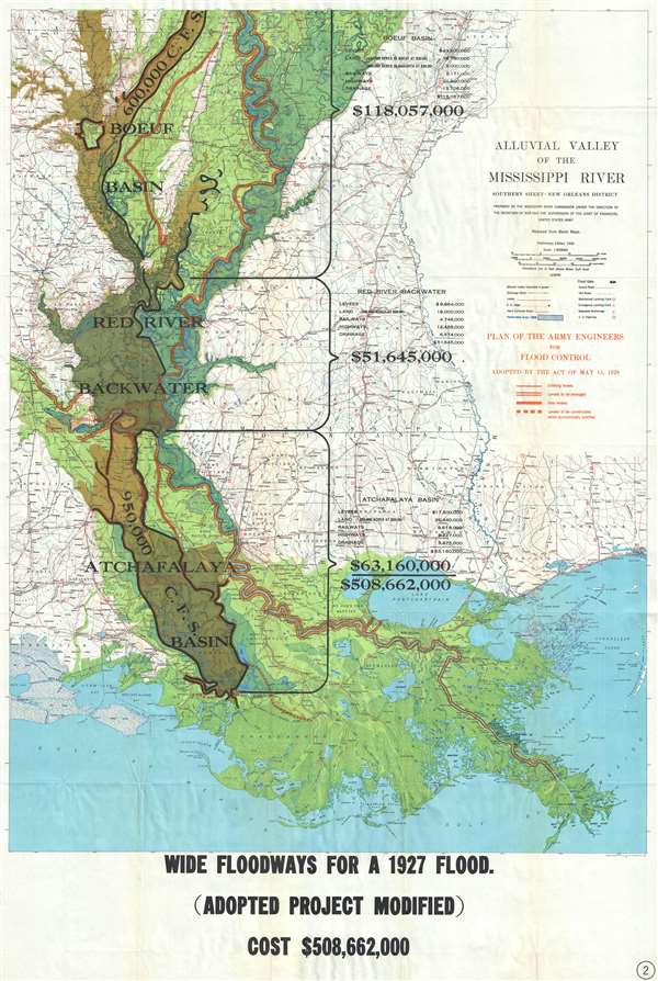
Alluvial Valley of the Mississippi River. Southern Sheet - New Orleans District.
sold
- Digital Map Information
- Suitable for large format printing
- File Size: 67.39 MB
- File Type: ZIP / TIFF
- ICC color profile embedded
- Delivered instantly via download link
This is a 1930 Mississippi River Commission map of the alluvial valley of the Mississippi River. This map depicts the Mississippi River alluvial valley from the Arkansas-Louisiana state border on the top to the Gulf of Mexico on the bottom ... (more details)
The first scientific geological survey of Iran - and an all around stunning map.
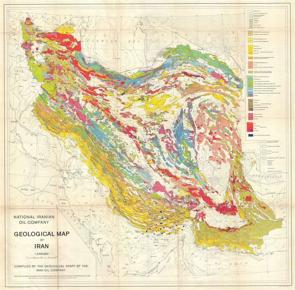
National Iranian Oil Company Geological Map of Iran.
sold
- Digital Map Information
- Suitable for large format printing
- File Size: 34.93 MB
- File Type: ZIP / TIFF
- ICC color profile embedded
- Delivered instantly via download link
An extremely rare, beautiful and important production, this is the 1959 geological map of Iran issued from original surveys by the National Iranian Oil Company (Shirkat-i Millī-i Naft-i Īrān) completed in 1957. This is the first ... (more details)
The first major construction of telegraph lines throughout the Philippines - built by the Signal Corps during the Philippine-American War.
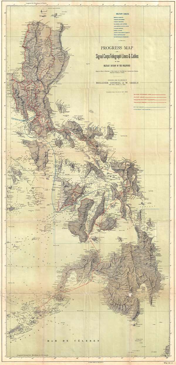
Progress Map of Signal Corps Telegraph Lines and Cables in the Military Division of the Philippines.
sold
- Digital Map Information
- Suitable for large format printing
- File Size: 22.28 MB
- File Type: ZIP / TIFF
- ICC color profile embedded
- Delivered instantly via download link
This is a scarce 1900 map of the Philippines prepared under the direction of General Adolphus Washington Greely. When this map was issued, Greely was the chief of the U.S. Army Signal Corps, in charge of constructing telegraph cables ... (more details)
One of the most detailed maps of Luzon issued during the Philippine-American War.

Southern Luzon. Showing Portion of Theater of Operations. 8th Army Corps, Major General Elwell S. Otis, Commanding.
sold
- Digital Map Information
- Suitable for large format printing
- File Size: 15.19 MB
- File Type: ZIP / TIFF
- ICC color profile embedded
- Delivered instantly via download link
This is an extremely rare map of Central Luzon, the Philippines, issued at the height of the Philippine-American War (1899 – 1902) by the Military Governor in the Philippines, Major General Elwell Stephen Otis and the 8th Army ... (more details)
Scarce highly detailed world and pacific theater map during World War II, 1943.
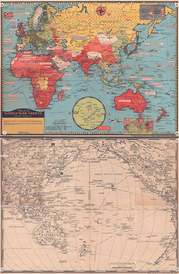
Map of the World War Fronts: Dated Events.
sold
- Digital Map Information
- Suitable for large format printing
- File Size: 20.96 MB
- File Type: ZIP / TIFF
- ICC color profile embedded
- Delivered instantly via download link
This is a double sided, highly detailed, and extremely rare 1943 Stanley Francis Turner pictorial map of the situation of World War II as of mid-1943. On the recto, a full color map of the Eastern Hemisphere is depicted, ... (more details)
Engaging Harrison orthographic projection FORTUNE Magazine map printed during World War II.
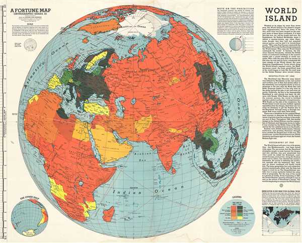
World Island. A Fortune Map. Orthographic Series, III.
sold
- Digital Map Information
- Suitable for large format printing
- File Size: 14.98 MB
- File Type: ZIP / TIFF
- ICC color profile embedded
- Delivered instantly via download link
This is a 1943 Richard Edes Harrison and Fortune Magazine orthographic map of the Eastern Hemisphere, including Asia, Africa, and Europe, which they refer to as the 'World Island'. The map depicts the continents of Asia, ... (more details)
Beautiful hand colored map of the Black Sea featuring ancient country names.
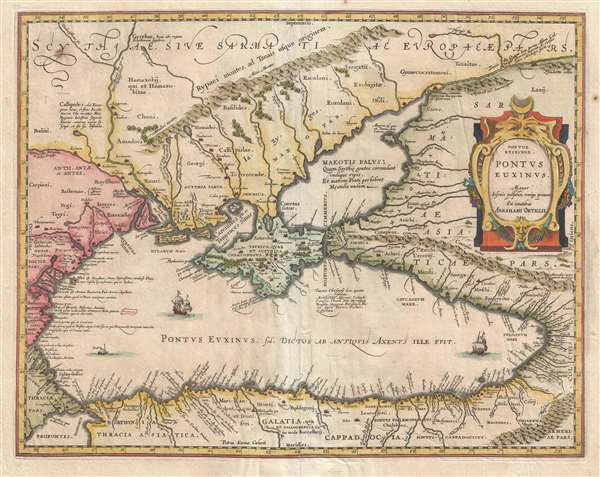
Pontus Euxinus.
sold
- Digital Map Information
- Suitable for large format printing
- DPI: 300
- File Size: 6.45 MB
- File Type: ZIP / TIFF
- ICC color profile embedded
- Delivered instantly via download link
This is a hand colored 1601 Abraham Ortelius map of the Black Sea and the surrounding region. The map depicts the Black Sea from Turkey, Romania, and Bulgaria on the left to Georgia, Russia, and Turkey on the right and ... (more details)
Map of West Africa issued at the height of the Atlantic Slave Trade.

Carte de la Barbarie, de la Nigritie, et de la Guinée. Par Guillaume Delisle de l'Academie Royale de Sciences. A Amsterdam Chez Jean Covens et Corneille Mortier, Geographes.
sold
- Digital Map Information
- Suitable for large format printing
- DPI: 300
- File Size: 11.82 MB
- File Type: ZIP / TIFF
- ICC color profile embedded
- Delivered instantly via download link
This is an excellent example of Jean Covens' and Corneille Mortier's 1742 edition of Guillaume Delisle's influential map of western Africa. This map was issued at the height of the Atlantic Slave Trade. It covers the ... (more details)
Attractive tourist map of Washington D.C.
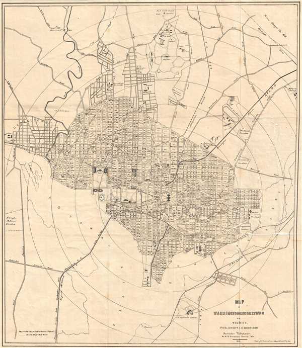
Map of Washington, Georgetown, and Vicinity depicting the Washington Monument 5 years before it opened to the public.
sold
- Digital Map Information
- Suitable for large format printing
- File Size: 6.83 MB
- File Type: ZIP / TIFF
- ICC color profile embedded
- Delivered instantly via download link
This is an 1882 W.H Morrison map of Washington D.C. and Georgetown. The map covers Washington D. C. from Georgetown and Arlington National Cemetery on the left to the eastern branch of the Potomac River on the right ... (more details)