
Intriguing city map or plan of Victoria, Hong Kong, the de facto capital during the British colonial period.

Plan of Hong Kong. City of Victoria. Drawn for Crow's 'Handbook for China.'
sold
- Digital Map Information
- Suitable for large format printing
- File Size: 3.33 MB
- File Type: ZIP / TIFF
- ICC color profile embedded
- Delivered instantly via download link
This is a 1921 Carl Crow city map or plan of Victoria, Hong Kong. The map depicts Victoria from Kennedy Road, Bowen Road, and the Navy Yard to Hollywood Road and the Western Market and from the public gardens and Robinson Road to Connaught Road and the port. All the streets are labeled, as well as several cathedrals, churches, and colleges. The government house is labeled in big block lettering. The Peak Tramway, which scales Victoria Peak, is depicted on the left side of the map, along with the tram station. Victoria was the de facto capital of Hong Kong during the British colonial period. Per Crow, 'outside of official documents, one rarely hears the name Victoria, the city being commonly given the name of the island,' Hong Kong. (more details)
Tolkien's Middle-Earth!

An Artist's Interpretation of Middle Earth including the Wild Lands - east, south, and north.
sold
This is a 1982 map of J. R. R. Tolkien's fantasy world 'Middle-Earth' by Peter C. Fenlon. Fans of Tolkien will be quick to recognize the northeastern part of the map, generally known as the Westlands, encompassing the main theater of both the Hobbit and The Lord of the Rings. The cartography for these areas, from Forodwaith to Umbar and from the western ocean (Belegaer) to the Sea of Rhûn, is drawn directly from the iconic map that accompanied the The Lord of the Rings. Unlike the maps published in Tolkien's famous books, the present map extends south and west to embrace the entire continent of Endor. Cartographically, Endor roughly mirrors Europe (Westlands), Africa (Haradwraith), and Asia (east of Rhûn). Although Tolkien's Legendarium does in fact give some hints regarding the lands and topography to the east of Mordor and Rhûn, much of the cartography here seems to have been imagined by Fenlon. Nonetheless, this map proved popular in the 1980s and was distributed to complement Iron Crown Enterprises successful LOTR-based role-playing game series. Although the map has no scale, we extrapolated a scale of 1:19000000 based on Tokien's statement that Mirkwood was 300 miles wide. (more details)
A beautiful example with unusual detail.
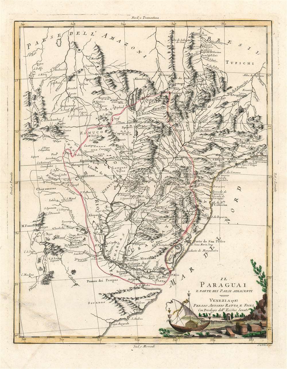
Il Paraguai E Parte Dei Paesi Adiacenti.
sold
- Digital Map Information
- Suitable for large format printing
- Full resolution TIFF file
- ICC color profile embedded
- Delivered instantly via download link
A beautiful example of Antonio Zatta's 1785 map of Paraguay. The map embraces the Rio de la Plata watershed well into Brazil and the Amazon, and includes the modern-day nations of Uruguay, Paraguay, and parts of adjacent Brazil and Argentina. Rich detail is offered throughout, naming mountains, rivers, national boundaries, cities, regions, and indigenous tribes. Identifies Asuncion, Buenos Aires, Rio de Janeiro, and numerous other important South American cities. (more details)
Highlights America's interventionist and paternalistic practices in Latin America.

The Pull of the Monroe Magnet.
sold
- Digital Map Information
- Suitable for large format printing
- File Size: 23.16 MB
- File Type: ZIP / TIFF
- ICC color profile embedded
- Delivered instantly via download link
This is a 1913 Udo Keppler political cartoon lambasting American protectorates in Latin America. The cartoon portrays Uncle Sam in a leisurely position, dressed in a star-spangled waistcoat and rede and white striped pants. His legs extend south toward the Gulf of Mexico and are drawn like the poles of a magnet. This magnet attracts Caribbean, Central, and South American countries (which are all personified as small Hispanic men wearing straw hats and white clothes). Their hats bear the name of the country each man represents. Panama appears in Uncle Sam's pocket, while Cuba grabs the end of one of the magnet's poles. Nicaragua and Costa Rica zoom across the Gulf pulled from the other coast by magnetic forces. Honduras, Guatemala, El Salvador, and Colombia cling to the far shore, trying as hard as they can to resist the unwanted advances. (more details)
The first edition of an iconic transportation map!
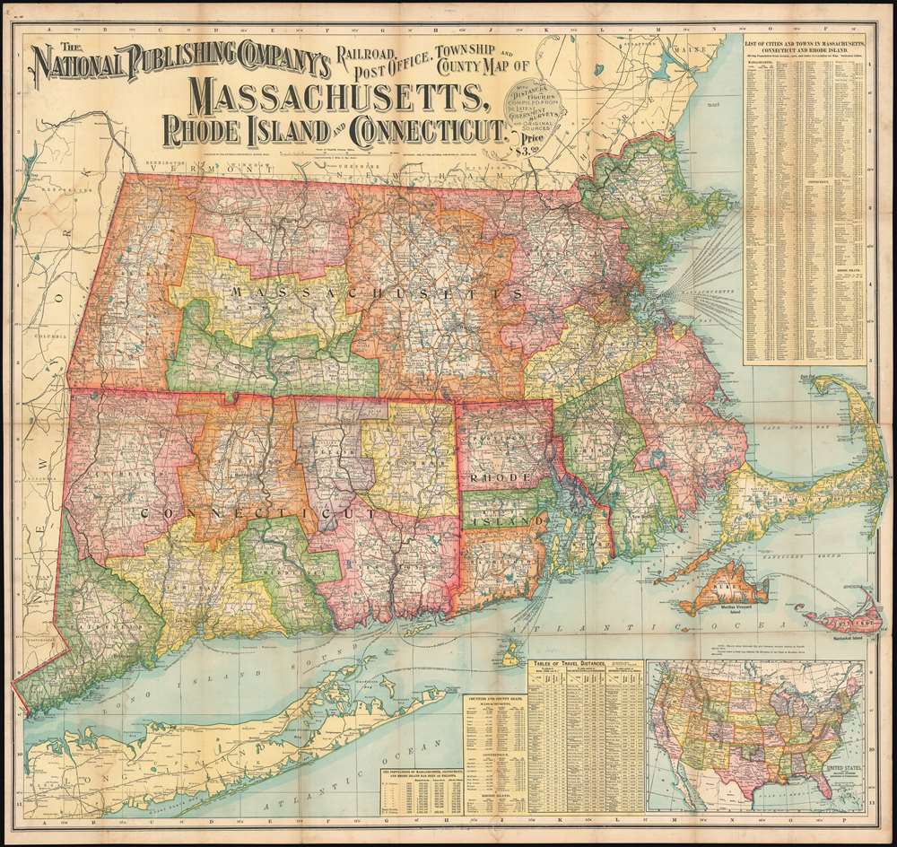
The National Publishing Company's Railroad, Post Office, Township and County Map of Massachusetts, Rhode Island and Connecticut.
sold
- Digital Map Information
- Suitable for large format printing
- File Size: 96.47 MB
- File Type: ZIP / TIFF
- ICC color profile embedded
- Delivered instantly via download link
This is a 1900 National Publishing Company map of Massachusetts, Connecticut, and Rhode Island. The map depicts all three states in their entirety, along with parts of Long. Island, New Hampshire, Vermont, New York State, and Maine. (more details)
Details the short-lived Old Colony and Newport Railroad.
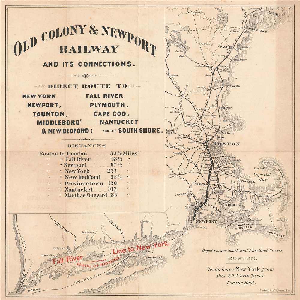
Old Colony and Newport Railway and its Connections.
sold
- Digital Map Information
- Suitable for large format printing
- File Size: 6.53 MB
- File Type: ZIP / TIFF
- ICC color profile embedded
- Delivered instantly via download link
This is a c. 1867 New England Lithographic Company railroad map of Massachusetts, Rhode Island, and Maine highlighting the Old Colony and Newport Railroad. The map depicts the region from Bath, Maine, south to Martha's Vineyard and Nantucket and west to Brooklyn and New York City. A thick black line connects Boston and Newport and represents the Old Colony and Newport Railroads. Stops along the Old Colony and Newport are labeled, including Taunton and Fall River. Individual stops are also identified between Braintree and Cohasset, and Braintree and Plymouth. Other connecting railroads, including the Fitchburg Railroad, Cape Cod Railroad, and the Boston and Maine Railroad, appear as thinner black lines. Most have circles marking stops, but only a few are labeled. The Cape Cod Railroad is an exception because every stop marked along its route is also identified. Red overprinting along in the bottom left quadrant promotes the Old Colony's steamship line between Fall River and New York City. An excellent illustration of a steamer occupies part of Long Island Sound to emphasize the ease with which this trip could be made. (more details)
An extremely rare map celebrating Lindbergh's first solo nonstop transatlantic flight.
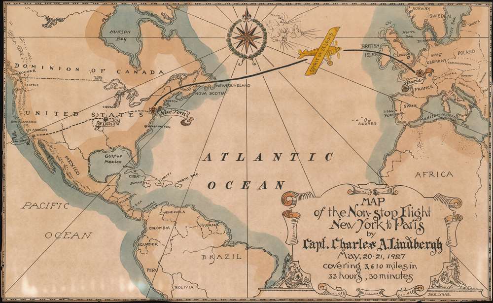
Map of the Non-Stop Flight New York to Paris by Capt. Charles A. Lindbergh May 20 - 21, 1927 covering 3,610 miles in 33 hours, 30 minutes.
sold
- Digital Map Information
- Suitable for large format printing
- File Size: 9.61 MB
- File Type: ZIP / TIFF
- ICC color profile embedded
- Delivered instantly via download link
This is a charming and rare c. 1927 map of Charles Lindbergh's historic first solo nonstop across the Atlantic in the now-iconic Spirit of St. Louis. The map depicts the region from the Pacific Ocean to Russia and from Hudson Bay and Scandinavia to South America. Spirit of St. Louis, colored yellow, appears over the mid-Atlantic, over half of the way to Paris, its destination on this legendary flight. San Diego, St. Louis, and New York are labeled in the United States, all-important waypoints on Lindbergh's flight. Very little other detail is present, except national borders and labels identifying the illustrated countries. Beautiful color adds to the appeal of this historic and extremely rare piece. (more details)
An Unrecorded First State of this Classic Dutch Map of Africa.
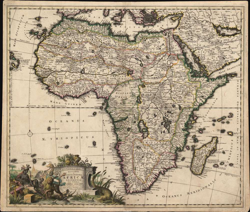
Novissima et perfectissima Africae descriptio.
sold
- Digital Map Information
- Suitable for large format printing
- Full resolution TIFF file
- ICC color profile embedded
- Delivered instantly via download link
This is a rare, newly-identified first state of Carel Allard's c. 1696 map of Africa. Most examples available on the market - themselves scarce - were included in Allard's 1697 Atlas Minor; both known earlier states were produced no later than 1697 and possibly as early as 1683, and were separately-issued maps, sometimes included in composite atlases and consequently of significantly greater rarity than comparable maps appearing in regularly-published atlases. (more details)
One of the most decorative maps of London of the 19th century.

Tallis's Illustrated Plan of London and its Environs in commemoration of the Great Exhibition of Industry of all Nations, 1851.
sold
- Digital Map Information
- Suitable for large format printing
- Full resolution TIFF file
- ICC color profile embedded
- Delivered instantly via download link
A superbly decorative 1851 John Tallis map of London with elaborate pictorial surround, this map was touted on its release as 'the most beautiful and perfect Plan of London ever produced.' With a finely engraved border consisting of forty illustrated views of London 'public buildings and places of amusement', the map lives up to the publisher's boisterous claim. Centered on Charing Cross, coverage extends from Stamford Hill to West Ham and from Brixton to Shepherds Bush. The map was issued to showcase the genius of British cartography, printing, and engraving at the 1851 Great Exhibition of the Works of Industry of All Nations, held in London. (more details)
The earliest Western city plan of Lhasa.
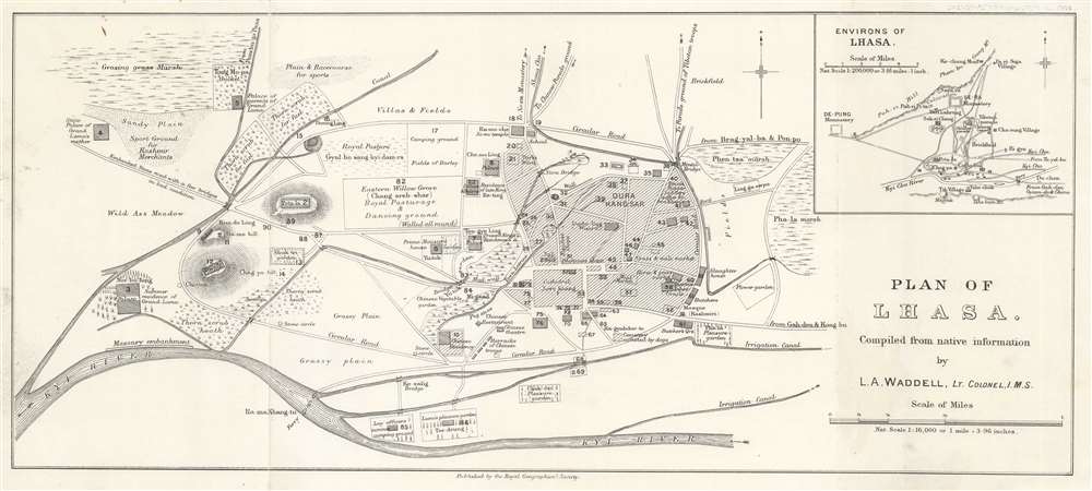
Plan of Lhasa.
sold
- Digital Map Information
- Suitable for large format printing
- Full resolution TIFF file
- ICC color profile embedded
- Delivered instantly via download link
This is a 1904 Laurence Austine Waddell city map or plan of Lhasa, Tibet, created during the 1903 - 1904 British Expedition to Tibet. Likely the earliest detailed plan of the city available outside of Tibet, numerous locations are identified, including bridges, walls, cathedrals, restaurants, and theaters. Markets, including the mule market, the horse market, and the meat market, are noted. Waddell differentiates between Nepalese, Bhutanese, and Chinese shops, and also includes two 'pleasure gardens', and even specifies the Lama's pleasure garden. Another note describes the cemetery as 'infested by dogs.' Ninety locations are numerically identified, but unfortunately, the index has been lost. We have included a screenshot of the index that we located online, but this is not included with the map. An inset map situated in the upper right corner the environs of Lhasa and identifies monasteries, cathedrals, and parade grounds. (more details)
Predicts a Solar Eclipse and reveals Arctic Explorations.

The geography of the great solar eclipse of July 14 MDCCXLVIII. : exhibiting an accurate map of all parts of the Earth in which it will be visible with the North Pole according to the latest discoveries.
sold
- Digital Map Information
- Suitable for large format printing
- Full resolution TIFF file
- ICC color profile embedded
- Delivered instantly via download link
This elegant, 1748 north polar projection map was drawn by the English astronomer and writer George Smith and engraved by the great English mapmaker Thomas Jefferys. It was produced for inclusion in Smith's pamphlet describing and predicting the path of the July 14, 1748, solar eclipse. Twenty-four diagrams show the expected appearance of the eclipsed sun as viewed from different cities, and the map's notation shows both the areas from which partial or full eclipses might be seen. The map's polar projection is presented obliquely to show all the parts of the known world from which the eclipse would be visible. As a result, Smith and Jefferys provide a snapshot of the general state-of-the-art of geographical knowledge of the northernmost parts of the globe to be reached by Europeans, during a period in which the English were active in their attempts to navigate those waters. (more details)
A newly-identified state of a charming pictorial map of the Finger Lakes.

A Romance Map of the Finger Lakes Region of Central New York.
sold
This is a newly-identified second state c. 1955 Sidney E. Ayres pictorial map of the Finger Lakes region of New York. Vignettes highlighting historical events and important figures who lived, worked, or were educated in the area, populate the map and surround the Finger Lakes. Beginning with Hiawatha's creation of the Iroquois Confederacy, the region's history leaps off the page. Special attention is paid to the colonial and revolutionary eras. Regional innovations, including the invention of the adding machine, the Pullman sleeper, the cast-iron plow, and 'talking' pictures (movies with sound) are heralded. Important historical figures with a connection to the area, such as Harriet Tubman, President Millard Fillmore, and Stephen A. Douglas, appear alongside Joseph Smith, the founder of the Mormon church, and Brigham Young. They both came from this part of the world. Joseph Smith may have even translated the 'Golden Plates' here in 1829. The 1848 Declaration of Sentiments was penned here by Susan B. Anthony and Elizabeth Cady Stanton during the first women's rights convention. Small texts line the left and right sides and provide short histories of some of the important events illustrated on the map. (more details)
Highlights the Allied losses after the German Spring Offensive and their gains during the Hundred Days Offensive.
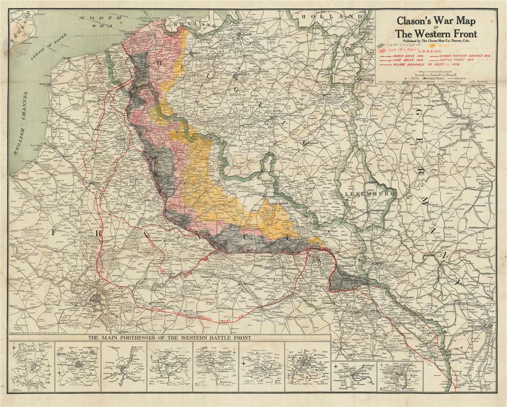
Clason's War Map of the Western Front.
sold
- Digital Map Information
- Suitable for large format printing
- Full resolution TIFF file
- ICC color profile embedded
- Delivered instantly via download link
This is a 1918 Clason Map Company map of northern France illustrating the movements of the front line in World War I through early September 1918. Unlike World War II, World War I was fought along mostly static lines of trenches in northern France and Belgium from 1914 through 1918. The map depicts the region from the English Channel and Dieppe to Strasburg (Strassburg) in Alsace, then part of Germany, and from Holland and the North Sea to Colmar. Red overprinting is used to illustrate the battle line at five different times during the four-year slaughter. The furthest line depicts the farthest advance of the German army, when they reached within thirty kilometers of the center of Paris before their advance was stopped by the French at the First Battle of the Marne. This is the battle that includes the fabled taxis of Paris ferrying soldiers to the battlefield. Dashed lines also trace the German offensives of March and June 1918, collectively known as the Spring Offensive. The line of X's marks the Allied campaign that began in August 1918 with the Battle of Amiens. Following the Allied success in the Battle of Amiens, the Germans fell back to the Hindenburg Line, a well-fortified defensive line that was established in 1917 and is illustrated and labeled here. The Hundred Days Offensive, in fact a series of battles that pushed back the Central Powers, eventually led to the end of the war. (more details)
Illustrates the Old City and the Temple Mount in detail.

Jerusalem Old and New.
sold
- Digital Map Information
- Suitable for large format printing
- Full resolution TIFF file
- ICC color profile embedded
- Delivered instantly via download link
This is a 1942 Steimatzky pictorial map of Jerusalem. The map depicts the city from Karem es Sila to El Tur and the Mount of Olives and from the Hadassa Medical Center, the Hebrew University and Mt. Scopus to Meqor Hayim. Illustrating numerous buildings in profile, the Old City and the Temple Mount act as the focal point. Surrounded by walls, several buildings within the Old City, such as the Holy Sepulcre, St. Anne's, the Supreme Muslim Council, and several gates are labeled. On the Temple Mount, the Dome of the Rock and the El Aksa Mosque are illustrated. Some of the locations illustrated outside the Old City include the Citadel, the Church of Dormition, the Tomb of the Virgin, the Tombs of the Kings, and several monasteries and convents. Neighborhoods throughout the city are labeled, along with streets and the railway which enters the city near the bottom of the map. (more details)
A Richly Decorative Engraving of a Theater of the Sixth Ottoman-Venetian War.
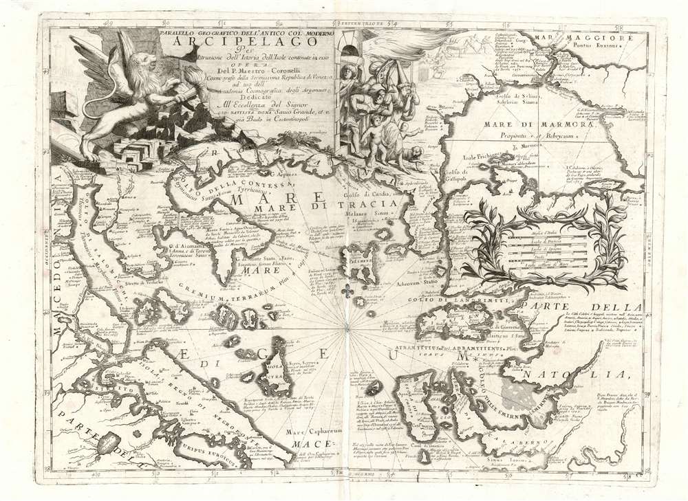
Paralello Geografico Dell'Antico Col Moderno Arcipelago Per Instruzione dell'Istoria dell'Isole contenute in esso.
sold
- Digital Map Information
- Suitable for large format printing
- Full resolution TIFF file
- ICC color profile embedded
- Delivered instantly via download link
This is a rare 1697 Vincenzo Coronelli map of the northern Greek Archipelago, showing Thessalia and north-western Turkey. The map focuses on the northern Aegean Sea and the Sea of Thrace, the Sea of Marmora, and their connection to the Black Sea via the Bosporus Strait. The Negroponte and Constantinople are prominent. Rich detail through offers historical notes illuminating both the recent history of the region, as well as the remote classical era, in order to lay the background for the momentous events celebrated in the map’s cartouche. (more details)
Celebrates MacArthur's return to the Philippines and the beginning of the Philippine Campaign.

Philippine Islands - Invaded by MacArthur.
sold
- Digital Map Information
- Suitable for large format printing
- Full resolution TIFF file
- ICC color profile embedded
- Delivered instantly via download link
This is a Monday, October 23, 1944 Van Swearingen and Chicago Daily Tribune map of the Philippines published days after the American landings on Leyte. Depicting the Philippine Islands from Luzon to Mindanao, red text boxes provide a concise overview of the history of World War II in the Philippines. Beginning with the Japanese invasion of Luzon on December 10, 1941, only two days after the Japanese attack on Pearl Harbor on December 7. Outnumbered and outgunned, American resistance was fierce, but unable to hold off the Japanese assault. Several notations around Luzon trace the Japanese invasion, including the first landing at Aparri and Vigan, the Japanese occupation of Manila on January 2, 1942, and the end of American resistance on the Bataan Peninsula on April 9, 1942 (which led to the infamous Bataan Death March). It also notes the surrender of Corregidor, an island fortress in Manila Bay, on May 6, 1942. General Douglas MacArthur had been in command of American forces in the Philippines and narrowing escaped from Corregidor before flying to Australia from an airfield on Mindanao in March 1942, which is also noted here. MacArthur vowed to return to the Philippines, and his triumphant return is celebrated here, with the landings on Leyte in October 1944. (more details)
Details plans to rejuvenate the National Mall and the surrounding area.
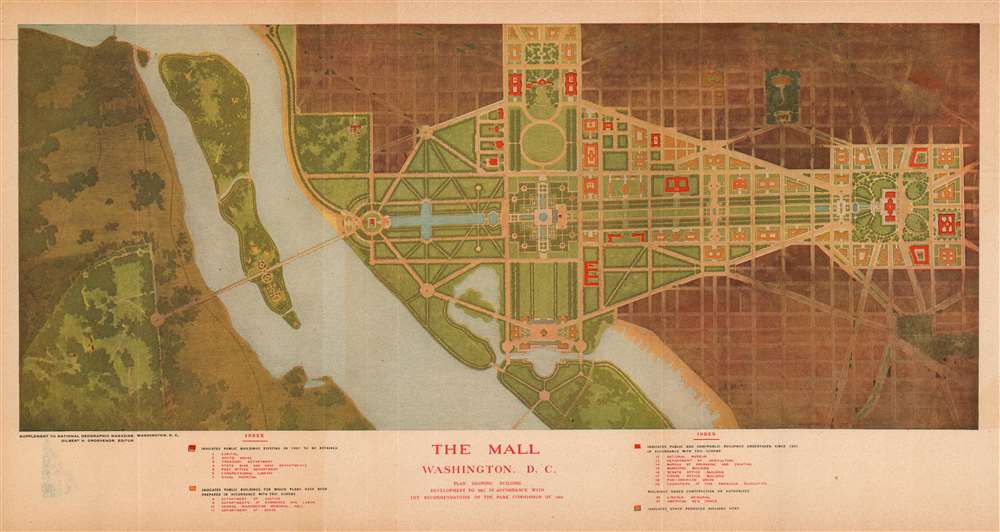
The Mall. Washington D.C. Plan Showing Building Development to 1915 in Accordance with the Recommendations of the Park Commission of 1901.
sold
- Digital Map Information
- Suitable for large format printing
- File Size: 17.98 MB
- File Type: ZIP / TIFF
- ICC color profile embedded
- Delivered instantly via download link
This is a 1915 National Geographic Society city plan or map of the National Mall in Washington, D.C. Depicting the region from Arlington National Cemetery to the Library of Congress and from Lafayette Square to where the Thomas Jefferson Memorial is today. Twenty-one buildings are illustrated around the Mall. Some, including the White House (No. 2), the Capitol Building (No. 1), the Library of Congress (No. 6), and recently constructed House and Senate office buildings, are shaded red, indicating that they had been built before 1901 or had been built between 1901 and 1915. Other buildings, such as buildings for the Departments of Justine, States, Commerce, and Labor, were proposed as part of the McMillan Plan, upon which this map was based. (more details)
America's fastest growing city?

[Cape Coral Plat. Southeast.]
sold
This is a c. 1961 plat or real-estate city map of the development of the southeastern part of Cape Coral, Florida. Lots, or 'sites' are numbered and shaded different colors to differentiate between price points. Patterns, such as dots, diagonal stripes, and cross-hatching, allow for even further specificity in price range. None of the streets within the development are labeled, and only two streets that act as boundaries are identified. However, the human-made lakes within the development have been named. Sites that have been set aside for use as motels, theaters, restaurants, schools, parks, and other civic projects are shaded white, just like the streets. Insets on both the recto and verso inform the viewer which parts of the city are shown. (more details)
The author's personal copy of an iconic Shanghai hunting map.

A Map of the Shooting Districts Lying Between Shanghai and Wuhu.
sold
- Digital Map Information
- Suitable for large format printing
- Full resolution TIFF file
- ICC color profile embedded
- Delivered instantly via download link
This Robert Alexis de Villard's own copy of his important 1893 hunting map of Shanghai and its environs. The map was created by de Villard in partnership the renowned sportsman Henling Thomas Wade, for use by expatriate hunting clubs in Shanghai. The map's coverage is expansive, bounded on the north and west by the main course of the Yangtze River, and on the east by Hangchow Bay. It includes from Nanjing (Nanking) and Zhenjiang (Chin-Kiang) to Hangzhou. Most locations are identified in English with Romanized Chinese. Some larger cities and towns, such as Nanjing (Nanking), Zhenjiang (Chin-Kiang), and Hangzhou (Hang-Chow), are also noted in Chinese. (more details)
Created from a captured Mexican map.
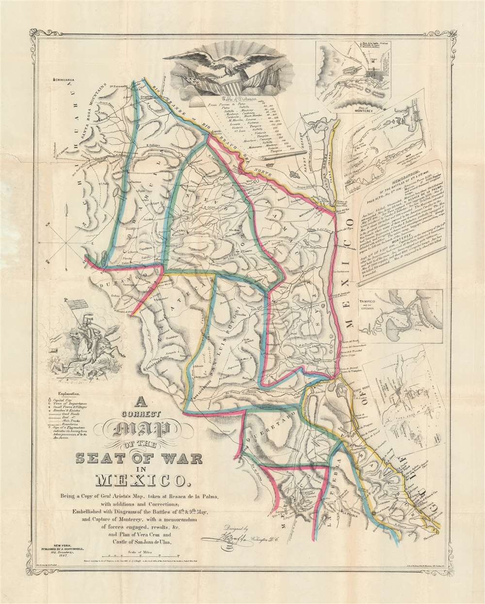
A Correct Map of the Seat of War in Mexico. Being a Copy of General Arista's Map, taken at Resaca de la Palma, with additions and Corrections; Embellished with Diagrams of the Battles of 8th and 9th May, and Capture of Monterey, with a memorandum of forces engaged, results, etc. and Plan of Vera Cruz and Castle of San Juan de Ulua.
sold
- Digital Map Information
- Suitable for large format printing
- Full resolution TIFF file
- ICC color profile embedded
- Delivered instantly via download link
This is a rare first-edition 1847 John Disturnell and Joseph Goldsborough Bruff map of the Mexico during the Mexican-American War (1846 - 1848). Depicting the region from Chihuahua to the Gulf of Mexico and from the Rio Grande to Mexico City, this map represents the most detailed cartography available to the United States Army at the beginning of the war. (more details)