
The life's work of the incredible geographer Clement Gillman - who spent most of his life in East Africa.
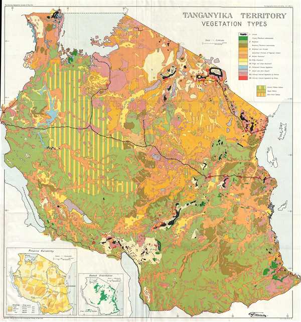
Tanganyika Territory Vegetation Types.
sold
- Digital Map Information
- Suitable for large format printing
- File Size: 10.92 MB
- File Type: ZIP / TIFF
- ICC color profile embedded
- Delivered instantly via download link
This is a 1949 Clement Gillman map of vegetation in Tanganyika (Tanzania) The map depicts the Tanganyika Territory, modern-day Tanzania, within its contemporary borders from Lake Victoria and Kenya to Zambia, Lake Malawi, Malawi, and Mozambique and from the Rwanda, ... (more details)
Iconic promotional map of Hawaii from its Territorial Period.
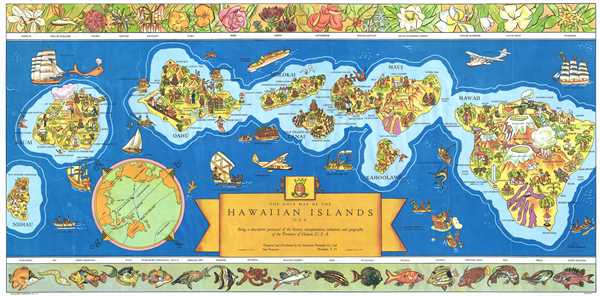
The Dole Map of the Hawaiian Islands U.S.A. Being a descriptive portrayal of the history, transportation, industries and geography of the Territory of Hawaii, U.S.A.`
sold
- Digital Map Information
- Suitable for large format printing
- File Size: 16.93 MB
- File Type: ZIP / TIFF
- ICC color profile embedded
- Delivered instantly via download link
This is a 1937 pictorial map of the Hawaiian Archipelago drawn by Parker Edwards and issued by the Dole Pineapple Company. The map depicts the Hawaiian Islands of Hawaii, Maui, Kahoolawe, Lanai, Molokai, Oahu, Kauai, and Niihau. Pictorial vignettes decorate each of ... (more details)
Miguel Gómez Medina's finest and rarest pictorial map!
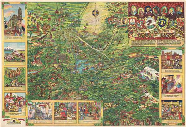
Mapa Pintoresco del Distrito Federal y Alrededores. Pictorial Map of the Federal District and Surroundings.
sold
- Digital Map Information
- Suitable for large format printing
- File Size: 29.55 MB
- File Type: ZIP / TIFF
- ICC color profile embedded
- Delivered instantly via download link
Issued during the Golden Age of Pictorial Maps (c. 1920 - 1960), this is a wonderful whimsical map of the Valley of Mexico City (DF, Distrito Federal) by Mexican artist Miguel Gómez Medina. Although not drawn to scale, the map centers on the lake of Xochimilco and extends north as far as the majestic ruins of Teotihuacan, and as far as the volcano Popocatépetl. The grid structure of the Centro Histórico and the Zócalo are obvious just to the north of the lake. Cartoon illustrations throughout focus on Mexican life and culture but also include highways and railroads – indications that Mexico is both rich in culture and rapidly embracing modern technological developments. The map proper is surrounded by scenes from Mexican life, including a street view of Cuernavaca, a village market, the Nevado de Toluca, the Convento de Tepotzotlan, and a night scene in the Zócalo during Mexican Independence Day La Noche de 'El Grito', among other scenes. (more details)
One of the earliest aerial survey's of a major city!
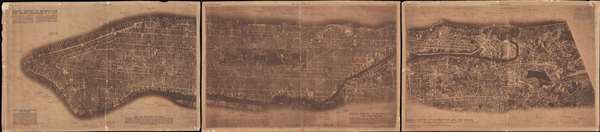
Aerial Survey of Manhattan and the Bronx.
sold
- Digital Map Information
- Suitable for large format printing
- Full resolution TIFF file
- ICC color profile embedded
- Delivered instantly via download link
This is a rare 1922 triptych aerial survey map of Manhattan Island, New York, prepared by the Fairchild Aerial Camera Corporation. This is mostly likely either the first or second aerial survey of a major city – the other being Fairchild's survey of Newark in ... (more details)
The converted mausoleum of Emperor Hadrian, this building became the Papal Fortress and is now a museum.

Veduta del Ponte, e del Mausoleo, fabbricati da Elio Adriano Impre.
sold
- Digital Map Information
- Suitable for large format printing
- DPI: 300
- File Size: 18.14 MB
- File Type: ZIP / TIFF
- ICC color profile embedded
- Delivered instantly via download link
This is a 1756 Giovanni Battista Piranesi view of the Castel Sant'Angelo, formerly Emperor Hadrian's Mausoleum, in Rome, Italy. The view depicts the Castel Sant'Angelo from across the Tiber River along with the St. Angelo Bridge, also known as the Pons Aelius or ... (more details)
Clear and specific map of the Virgin Islands and the Leeward Islands.
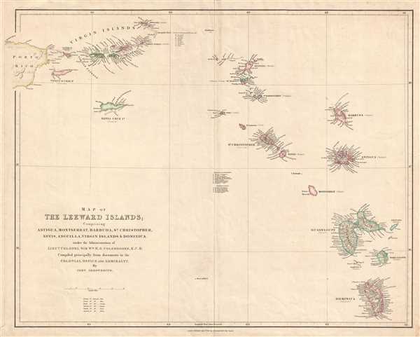
Map of the Leeward Islands; Comprising Antigua, Montserrat, Barbuda, St. Christopher, Nevis, Anguilla, Virgin Islands, and Dominica.
sold
- Digital Map Information
- Suitable for large format printing
- DPI: 300
- File Size: 7.18 MB
- File Type: ZIP / TIFF
- ICC color profile embedded
- Delivered instantly via download link
This is an 1842 John Arrowsmith map of the Virgin Islands and the Leeward Islands. The map depicts the Caribbean Sea from Anegada (a British possession) to Dominica (also a British possession) and from Puerto Rico (Porto Rico, which was Spanish) to Deseada (a ... (more details)
Dramatic view of the Black Hills during the height of the Black Hills Gold Rush!
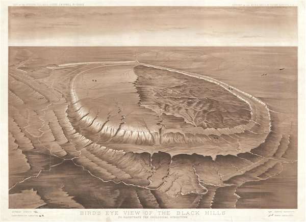
Bird's Eye View of the Black Hills to Illustrate the Geological Structure.
sold
- Digital Map Information
- Suitable for large format printing
- File Size: 13.97 MB
- File Type: ZIP / TIFF
- ICC color profile embedded
- Delivered instantly via download link
This is an 1879 Henry Newton view and map of the Black Hills during the height of the Black Hills Gold Rush. The Black Hills are a spectacular mountain range in the northern plains states of South Dakota and Wyoming. The view was designed by Newton to ... (more details)
Created by a U.S. Geological Survey expedition during the height of the Black Hills Gold Rush!
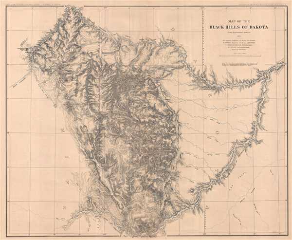
Map of the Black Hills of Dakota.
sold
- Digital Map Information
- Suitable for large format printing
- File Size: 29.55 MB
- File Type: ZIP / TIFF
- ICC color profile embedded
- Delivered instantly via download link
This is an 1879 Henry Newton map of the Black Hills during the height of the Black Hills Gold Rush. The Back Hills are a spectacular mountain range in the northern plains states of South Dakota and Wyoming. Per Carl Wheat, the map depicts from 102 ... (more details)
Colorful Geological survey view of the Black Hills height of the Black Hills Gold Rush!
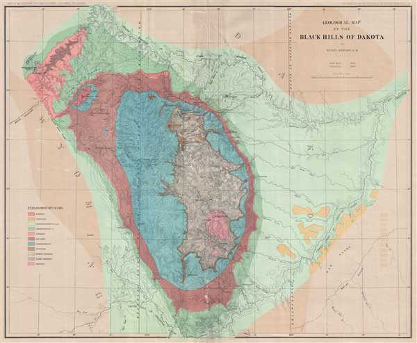
Geological Map of the Black Hills of Dakota.
sold
- Digital Map Information
- Suitable for large format printing
- File Size: 19.2 MB
- File Type: ZIP / TIFF
- ICC color profile embedded
- Delivered instantly via download link
This is an 1879 Henry Newton geological map of the Black Hills during the height of the Black Hills Gold Rush. The Black Hills are a spectacular mountain range in the northern plains states of South Dakota and Wyoming. Per Carl Wheat, the map ... (more details)
Remarkable and extremely rare Spanish nautical chart of Central America, Colombia, and the antilles.
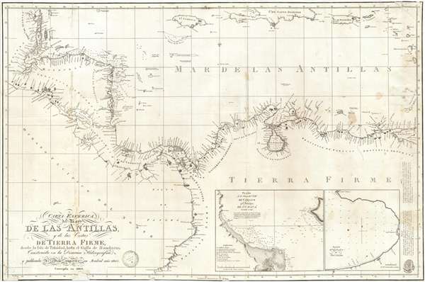
Carta Esferica del Mar de Las Antillas y de la Costas de Tierra Firme, desde la Isla de Trinidad, hasta el Golfo de Honduras Construida en la Direccion Hidrografica y pubicada de orden superior en Mardrid ano 1805.
sold
- Digital Map Information
- Suitable for large format printing
- Full resolution TIFF file
- ICC color profile embedded
- Delivered instantly via download link
A rare Spanish Dirección de Hidrografía 1809 nautical chart or maritime map of the coasts of Central America, Colombia, and Venezuela. The map covers from the Gulf of Honduras to Panamá and Maracaibo. In extends north to include the ... (more details)
Fantastic chart labeling both Montevideo and Buenos Aires - with insets details both!
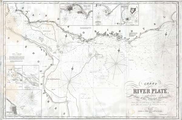
Chart of the River Plate, with Enlarged Plans of the Principal Harbors.
sold
- Digital Map Information
- Suitable for large format printing
- File Size: 17 MB
- File Type: ZIP / TIFF
- ICC color profile embedded
- Delivered instantly via download link
This is an 1856 James Imray blueback nautical chart or maritime map of the Río de la Plata in South America. The map depicts the Río de la Plata from Buenos Aires (Buenos Ayres) and the Entrance of the River Parana to Palmarones Island and from the entrance of the Uruguay River to Cape Saint Antonio. A highly detailed chart, this example shows evidence of having been used on board a ship. Both Montevideo and Buenos Aires are labeled, along with numerous other points along the coastline, including several mountains and hills that would be identifiable at sea. Innumerable depth sounding populate the bulk of the chart along with several banks. Hazards to the mariner are clearly marked. Three different compass roses are included. A note along the left border that warns the viewer that the shape of the shoals and depth of water over them is very likely to have changed since the last survey. The final sentence is a cautionary one – stating that 'strangers bound up the river beyond Monte Video ought to obtain a pilot.'
Six different inset maps are included around the border of the chart. These include Colonia and the Hornosi Islands, the Bay of Barragan, Buenos Aires (Buenos Ayres), Montevideo (Monte Video), the road of Maldonado, and the Anchorage of Cape St. Mary. Each of these inset maps includes numerous depth soundings and a detailed depiction of the area in question. (more details)
Six different inset maps are included around the border of the chart. These include Colonia and the Hornosi Islands, the Bay of Barragan, Buenos Aires (Buenos Ayres), Montevideo (Monte Video), the road of Maldonado, and the Anchorage of Cape St. Mary. Each of these inset maps includes numerous depth soundings and a detailed depiction of the area in question. (more details)
Illustrates in great detail the region from Rainy Lake through Namakan Lake to Lac la Croix.
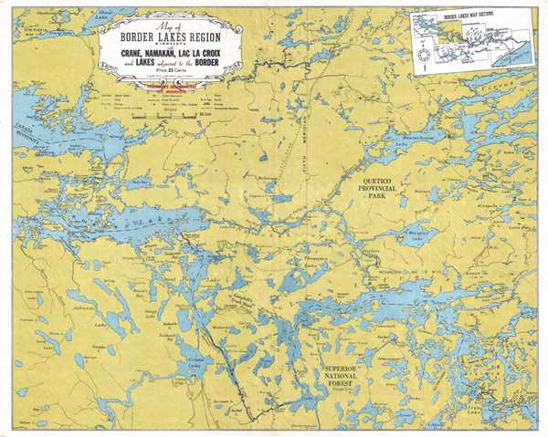
Map of Border Lakes Region Minnesota with Crane, Namakan, Lac La Croix, and Lakes Adjacent to the Border.
sold
- Digital Map Information
- Suitable for large format printing
- File Size: 7.51 MB
- File Type: ZIP / TIFF
- ICC color profile embedded
- Delivered instantly via download link
This is a 1939 W. A. Fisher Company map of the border lakes region of Minnesota of the vicinity around Namaka Lake, Crane Lake, and Lac la Croix. The map depicts from the eastern end of Rainy Lake Rebecca Falls and Curtain Falls and from ... (more details)
Illustrates in great detail the region around Lake Vermilion.
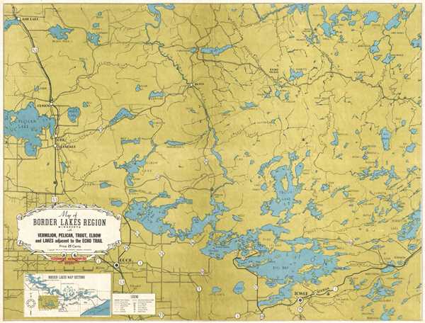
Map of Border Lakes Region Minnesota with Vermilion, Pelican, Trout, Elbow, and Lakes Adjacent to the Echo Trail.
sold
- Digital Map Information
- Suitable for large format printing
- File Size: 6.19 MB
- File Type: ZIP / TIFF
- ICC color profile embedded
- Delivered instantly via download link
This is a 1941 W. A. Fisher Company map of the border lakes region of Minnesota of the vicinity around Lake Vermilion, Trout Lake, and Pelican Lake. The map depicts the region from Pelican Lake to Burntside Lake and from Loon Lake to ... (more details)
Illustrates in great detail the region around Rainy Lake and Kabetogama Lake.
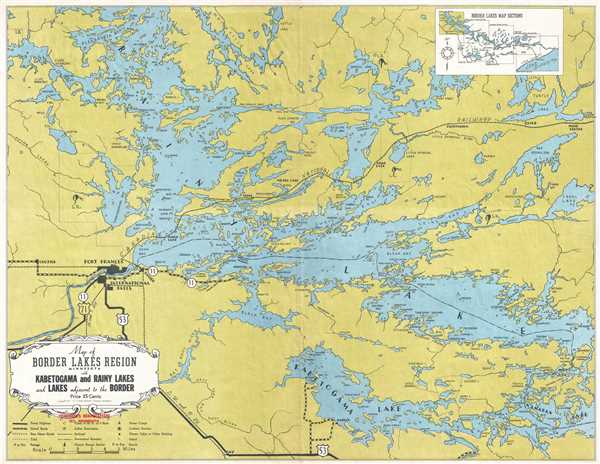
Map of the Border Lakes Region Minnesota with Kabetogama and Rainy Lakes and Lakes Adjacent to the Border.
sold
- Digital Map Information
- Suitable for large format printing
- File Size: 6.07 MB
- File Type: ZIP / TIFF
- ICC color profile embedded
- Delivered instantly via download link
This is a 1939 W. A. Fisher Company map of the border lakes region of Minnesota around Rainy Lake and Kabetogama Lake. The map depicts the region from west of Fort Frances and International Falls to Namakan Lake, Shoal Lake, and Mine ... (more details)
The Colton Map - one of the largest and most beautiful maps of New York City pulished in the 19th century - in an unrecorded state.
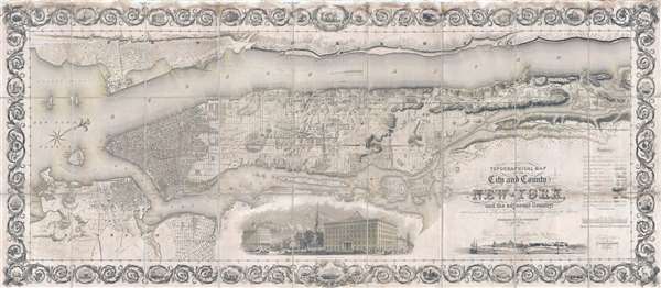
Topographical Map of the City and County of New-York, and the adjacent Country: With Views in the border of the principal Buildings and interesting Scenery of the Island.
sold
- Digital Map Information
- Suitable for large format printing
- DPI: 300
- File Size: 74.68 MB
- File Type: ZIP / TIFF
- ICC color profile embedded
- Delivered instantly via download link
Known as 'The Colton Map,' this is an unrecorded state of an 1840 map of New York City (Manhattan) by David H. Burr and John Hutchins Colton considered to be the finest and most decorative map of the city to appear in the 19th ... (more details)
Cheerful yet menacing pictorial map of Northern Manchuria around Harbin.
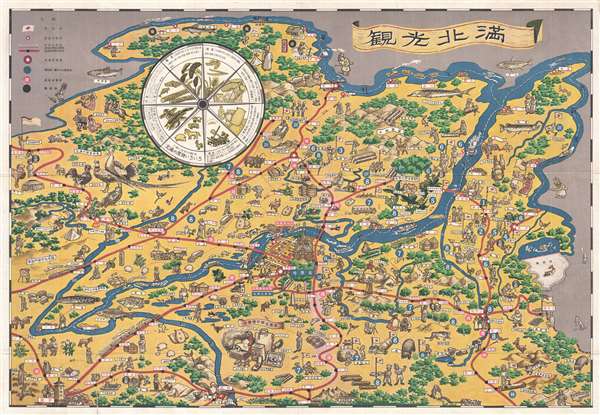
滿北光觀 / North Manchu Sightseeing. / Kankō Hokuman
sold
- Digital Map Information
- Suitable for large format printing
- DPI: 300
- File Size: 8.02 MB
- File Type: ZIP / TIFF
- ICC color profile embedded
- Delivered instantly via download link
A charming 1939 pictorial map of Heilongjiang (Harbin), Northern Manchuria, China. This map was issued by the Japanese run Harbin Railroad Foundation to promote tourism and commerce in and around the city of Harbin, in ... (more details)
Scarce educational Broadside - Tree of Liberty!

Tree of Liberty.
sold
- Digital Map Information
- Suitable for large format printing
- DPI: 300
- File Size: 19.61 MB
- File Type: ZIP / TIFF
- ICC color profile embedded
- Delivered instantly via download link
A wonderful bit of broadside Americana, this is a c. 1849 Edward Hooker Ensign and Horace Thayer illustration of the 'Tree of Liberty.' The tree, which grows from roots surrounded by hard working Americans, consists of ... (more details)
St. Eustatius was key to the American victory during the American Revolutionary War.
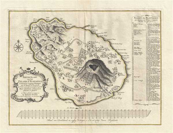
Nieuwe Kaart van het Eyland St. Eustatius in derzelver Ligging en Plantagien met de Naamen der Besitteren, Op Order van de Generaale Geoctroojeerde West-Indische Compagnie.
sold
- Digital Map Information
- Suitable for large format printing
- DPI: 300
- File Size: 9.73 MB
- File Type: ZIP / TIFF
- ICC color profile embedded
- Delivered instantly via download link
This is a rare 1775 Reinier Ottens map of Saint Eustatius, an island in the Caribbean. The map depicts the entirety of the island, from Buccaneer's Bay to Venus Bay and from to Company Bay. Ordered by the Dutch West ... (more details)
Rare and beautiful separate issue coast survey illustrating the Cape Cod region of Hyannis.
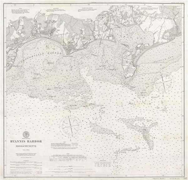
Hyannis Harbor Massachusetts.
sold
- Digital Map Information
- Suitable for large format printing
- File Size: 17.79 MB
- File Type: ZIP / TIFF
- ICC color profile embedded
- Delivered instantly via download link
A very attractive 1906 separate issue U. S. Coast and Geodetic Survey nautical chart of coastal map of Hyannis Harbor. Centered on Hyannis Point, the map covers from Osterville to Parker's River, including Lewis ... (more details)
Incredible advertisement for post-war travel from France to the Far East.
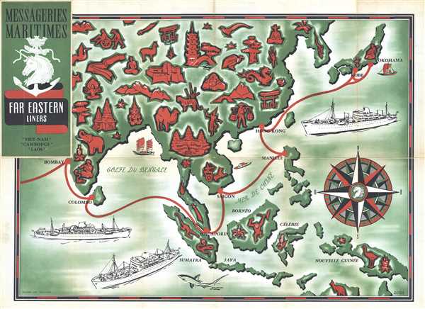
Messageries Maritimes Far Eastern Liners
$350.00
Acquire
- Digital Map Information
- Suitable for large format printing
- File Size: 15.23 MB
- File Type: ZIP / TIFF
- ICC color profile embedded
- Delivered instantly via download link
This is a 1954 Jacques Branger pictorial map advertising Messageries Maritimes' route through East Asia. The map depicts Asia from India to Japan and New Guinea and from Mongolia and Korea to extreme northern ... (more details)