
Iconic photo record of Old Shanghai.

Shanghai of To-day. A Souvenir Album of Thirty-Eight Vandyke Gravure Prints of the 'Model Settlement'.
sold
This is the 1927 First Edition of Kelly and Walsh's Shanghai of To-day. A Souvenir Album of Thirty-Eight Vandyke Prints of the 'Model Settlement'. The volume of large format photos captures evocative images of Shanghai's pre-war golden age, when it was a center of global commerce, art, political intrigue, and international cosmopolitanism. (more details)
Behold! A Rare, Lafreri-school Geneva.

[Geneva].
sold
- Digital Map Information
- Suitable for large format printing
- File Size: 6.91 MB
- File Type: ZIP / TIFF
- ICC color profile embedded
- Delivered instantly via download link
This is a rare 1567 prospect of Geneva, Switzerland, engraved by Paolo Forlani. It presents the city as 'Protestant Rome,' the seat of the Reformation in Europe. The Italian Catholic engraver of the map addresses his audience: Behold how curious the world is today to see the site and form of Geneva! The city's distinctive profile, remoteness, and unfamiliarity to the Catholic reader doubtless inspired wonder. (more details)
Yogi's antics in Jellystone Park!

Official Yogi Bear Map of Jellystone Park.
sold
This is a 1961 Hanna-Barbera Productions pictorial map of Yogi Bear and Jellystone Park. This piece was published the same year Yogi Bear got his first stand-alone show, The Yogi Bear Show. (more details)
The how-to of topographical draftsmanship.

Modèles de Topographie Dessinés et Lavés. / Modelli de Topografia Disegnati e Acquerellati.
sold
This is a fascinating 1840 instruction book in French and Italian describing the methods and techniques of topographical mapmaking and draftsmanship. Such works were used in military academies and civil engineering schools, laying the groundwork for the standardization of draftsmanship and topographic conventions in Europe - a major evolution over the ad hoc methodologies that dominated 18th-century mapmaking, (more details)
A little known coast...
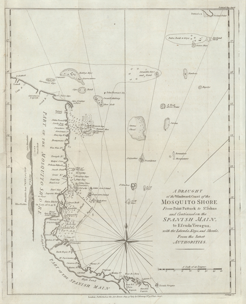
A Draught of the Windward Cost of the Mosquito Shore from Point Pattuck to St. Johns and Continued on the Spanish Main, to Escuda Veragua with the Islands, Keys, and Shoals, From the latest Authorities.
sold
- Digital Map Information
- Suitable for large format printing
- File Size: 5.89 MB
- File Type: ZIP / TIFF
- ICC color profile embedded
- Delivered instantly via download link
This is a scarce 1785 John Lodge map of the Mosquitia or Mosquito Coast, roughly corresponding to present-day eastern Nicaragua and Costa Rica. The map was issued to illustrate the heated colonial conflict between England and Spain over the remote and inhospitable coastline. (more details)
San Francisco and San Mateo: Streetcars and Fabulous Estates.
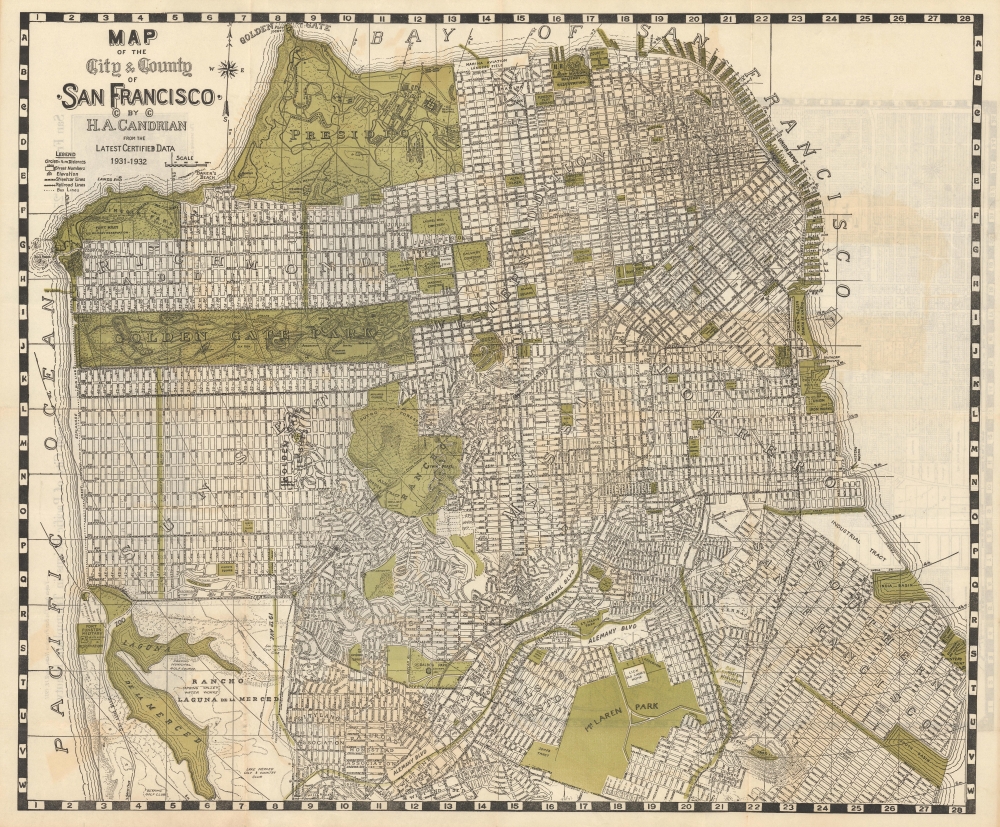
Map of the City and County of San Francisco. / Map of San Mateo and Burlingame.
sold
- Digital Map Information
- Suitable for large format printing
- Full resolution TIFF file
- ICC color profile embedded
- Delivered instantly via download link
This is an appealing c. 1932 map of San Francisco and San Mateo, California, by Hermon Anton Candrian and Davenport Bromfield. (more details)
Mapping New York Nightlife.

Hagstrom's Map of High Spots in New York.
sold
- Digital Map Information
- Suitable for large format printing
- Full resolution TIFF file
- ICC color profile embedded
- Delivered instantly via download link
This is a 1945 Hagstrom map of New York City, presenting an enlightening overview of New York nightlife near the end of the war era. (more details)
Navigating Brooklyn.

Brooklyn (New York City) Featuring House Numbers, Transit Lines, Playground, Wading Pools, etc.
sold
- Digital Map Information
- Suitable for large format printing
- File Size: 56.76 MB
- File Type: ZIP / TIFF
- ICC color profile embedded
- Delivered instantly via download link
This is a c. 1950 Geographia Map Company city plan or map of Brooklyn, New York. (more details)
The Adirondacks emerging as a wilderness paradise.

The Adirondack Picture Map.
sold
- Digital Map Information
- Suitable for large format printing
- File Size: 28.24 MB
- File Type: ZIP / TIFF
- ICC color profile embedded
- Delivered instantly via download link
A charming 1922 Arthur S. Knight pictorial map of the Adirondack region of New York, including both Lake Champlain and Lake George. This map was issued in the year the Adirondack Mountain Club was founded. (more details)
First full-size folio map of North America.
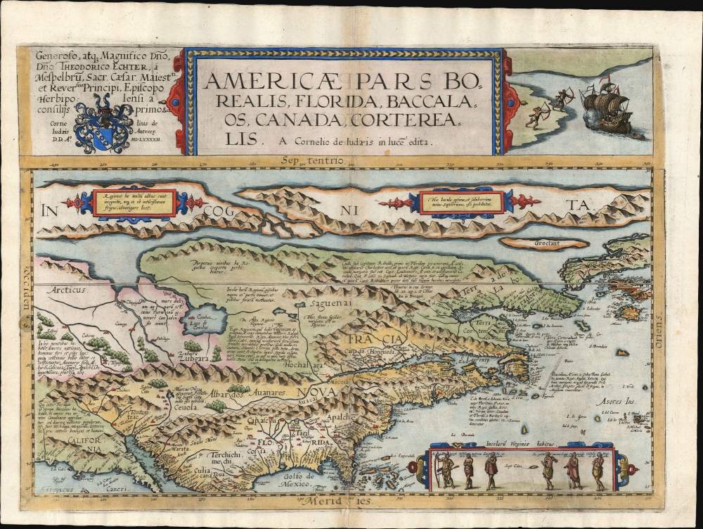
Americae Pars Borealis, Florida, Baccalaos, Canada, Corterealis.
sold
- Digital Map Information
- Suitable for large format printing
- Full resolution TIFF file
- ICC color profile embedded
- Delivered instantly via download link
This is Cornelis De Jode's rare map of North America, printed in a single edition of 1593. The first full-size folio map specifically of North America, it was among the updated maps added to the De Jode atlas specifically to compete with Ortelius' Theatrum Orbis Terrarum. To this end, it combined cartographic information from current sources with a level of decorative flourish that had not yet appeared in any atlas. In the case of this map, Cornelis focused on a part of the world omitted from the elder De Jode's 1578 atlas. (more details)
First printed nautical chart of Virginia and North Carolina.
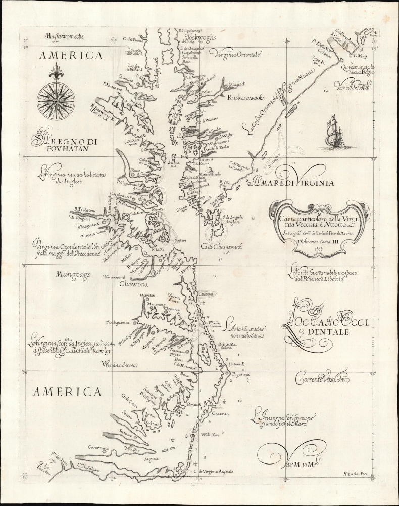
Carta particolare della Virginia Vecchia e Nuoua : la longitune comica da l'Isola di Pico di Asores : d'America carta, III.
sold
- Digital Map Information
- Suitable for large format printing
- File Size: 13.05 MB
- File Type: ZIP / TIFF
- ICC color profile embedded
- Delivered instantly via download link
A seminal chart, this is a superb 1661 example of Sir Robert Dudley's 1647 maritime map of the mouth of the Chesapeake Bay and the Carolina Sounds. In its first edition, this was the first printed nautical chart of that region. As per the title, the chart depicts the coasts of 'Old and New Virginia,' meaning the colonial efforts of Sir Walter Raleigh and the Jamestown Colony, respectively. Due to the Virginia Colony's importance to the English, Dudley's chart focuses more sharply on the region than on his other North American charts. (more details)
Earliest Acquirable map to name 'America'

Orbis Typus Universalis Iuxta Hydrographorum Traditionem Exactissime Depicta. 1522 L. F.
sold
- Digital Map Information
- Suitable for large format printing
- File Size: 17.38 MB
- File Type: ZIP / TIFF
- ICC color profile embedded
- Delivered instantly via download link
This is Lorenz Fries' 1522 map of the world in its 1535 edition: a key discovery-era document, being the second earliest acquirable printed map to name 'America' (appearing here in South America). (more details)
First printed map to illustrate the Chesapeake Bay.

Americae Sive Novi Orbis Nova Descriptio.
sold
- Digital Map Information
- Suitable for large format printing
- Full resolution TIFF file
- ICC color profile embedded
- Delivered instantly via download link
This is Abraham Ortelius' map of the Americas in an attractive, early example of the 1587 third plate, printed in 1589. It represents the state-of-the-art mapping of the Western Hemisphere during the initial period of European Colonization. It is significant as the first printed map to illustrate the Chesapeake Bay, predating John White's 1590 map of Virginia. (more details)
Striking whiteprint wall map of Denver.
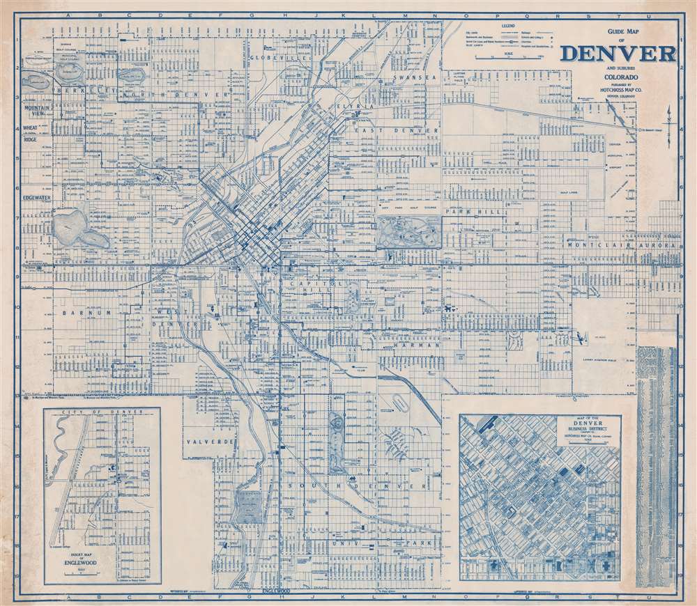
Guide Map of Denver and Suburbs Colorado.
$950.00
Acquire
- Digital Map Information
- Suitable for large format printing
- File Size: 74.65 MB
- File Type: ZIP / TIFF
- ICC color profile embedded
- Delivered instantly via download link
This is a striking diazo or whiteprint c. 1946 wall map of Denver, Colorado, by the locally based Hotchkiss Map Company. Centered on Capitol Hill, this map covers all of Denver from Lakeside Lake to Aurora and from 54th Avenue to Englewood. An inset map of Englewood occupies the lower left, while another inset on the lower right details the Denver Business District. The map is highly detailed, showing streets, individual buildings, parks, route numbers, railway lines, churches, schools, and other features. It is extremely large - not to be confused with Hotchkiss' smaller but otherwise similar map appearing in his Denver guide. The diazo medium necessarily limits the number of maps produced - thus underscoring this map's exceptional nature. (more details)
Celebrating Maine's wildlife and outdoor activities.
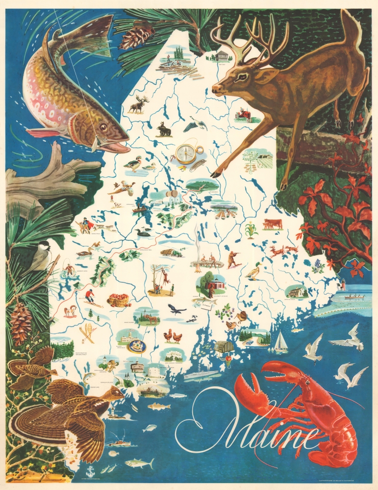
Maine.
sold
This is a 1969 J.G. Shelley and Louis Koster pictorial wall map of Maine. Shelley and Koster's work celebrates Maine's iconic wildlife and the many outdoor activities one can enjoy while in Maine. (more details)
Busy but treacherous seas.

A Chart of the Bay of Biscay compiled from the latest French and Spanish surveys.
sold
- Digital Map Information
- Suitable for large format printing
- File Size: 52 MB
- File Type: ZIP / TIFF
- ICC color profile embedded
- Delivered instantly via download link
A rare 1860 blueback nautical map of the Bay of Biscay, prepared by John Stratton Hobbs and published by Charles Wilson. The Bay represents some of the worlds most active but unpredictably dangerous waters notorious for rough seas and treacherous storms. (more details)
Remarkable 1869 map or plan of Prospect Park, Brooklyn.

Design for Prospect Park in the City of Brooklyn.
sold
- Digital Map Information
- Suitable for large format printing
- File Size: 11.59 MB
- File Type: ZIP / TIFF
- ICC color profile embedded
- Delivered instantly via download link
This is a rare 1869 edition of Calvert Vaux and Frederick Law Olmsted's map of Prospect Park, Brooklyn. The map depicts the park as a whole and includes pathways, lakes, buildings, individual trees, rocks, and elevation measurements. The streets and avenues surrounding the park are also noted. (more details)
First advertisement for sliced bread.

Help Mickey Mouse Beat the Big Bad Wolf - Do Your Part - Buy the Bread with the Mickey Mouse Band and Follow the Race 'Round the World.
sold
- Digital Map Information
- Suitable for large format printing
- Full resolution TIFF file
- ICC color profile embedded
- Delivered instantly via download link
This is a 1936 Walt Disney Mickey Mouse Globe Trotters Club pictorial map of the world issued as part of the first advertising campaign for sliced bread - that's right, 'Sliced Bread'! The map depicts the world from the Americas, across the Atlantic Ocean to Europe, Africa, and Asia, to Australia and the Pacific Ocean. (more details)
Staking a Claim for France in the Pacific.

Carte de l'Archipel des Anambas (Mer de Chine) Reconnu en Mars et Avril 1831, Par le Capitaine de Frégate LAPLACe, commandant la Corvette de S.M. la Favorite, Levée et Dresée par Mr. E. Pâris, Enseigne de Vau. Campagne autor du Monde, en 1830, 1831 et 1832.
sold
- Digital Map Information
- Suitable for large format printing
- Full resolution TIFF file
- ICC color profile embedded
- Delivered instantly via download link
An example of Ambroise Tardieu's 1833 nautical chart or map of the Anambas Islands in the Riau Islands of Indonesia, surveyed in 1831 during the circumnavigation voyage of Cyrille Pierre Théodore Laplace. (more details)
Considered to be the first scientific mapping of South Africa.
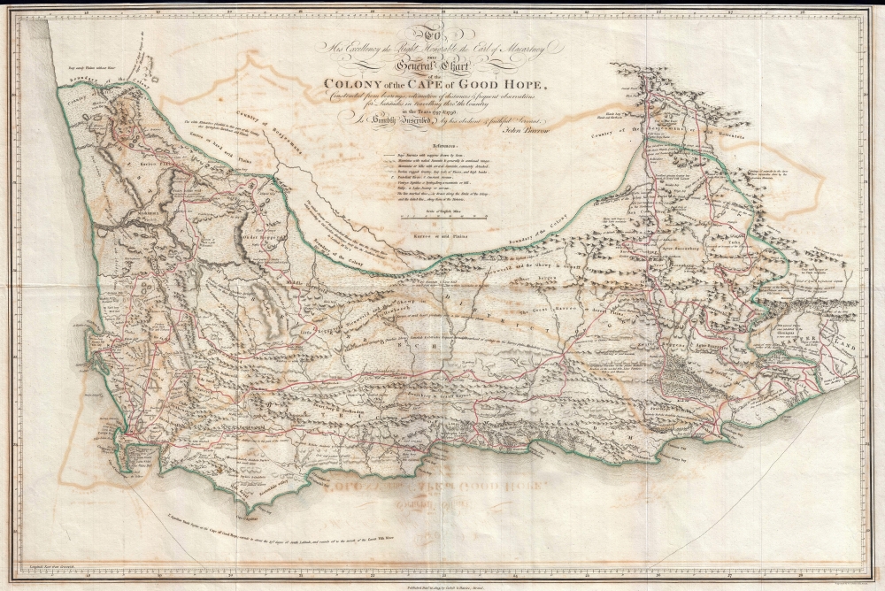
To His Excellence the Right Honorable Earl of Macartney This General Chart of the Colony of the Cape of Good Hope, Constructed from bearing, estimation of distances and Frequent observations for Latitudes in Travelling throu' the Country in the Years 1797 and 1798 is Humbly Inscribe, by his Obedient and Faithful Servant, John Barrow.
sold
- Digital Map Information
- Suitable for large format printing
- DPI: 300
- File Size: 13.04 MB
- File Type: ZIP / TIFF
- ICC color profile embedded
- Delivered instantly via download link
Considered to be the first scientific mapping of South Africa, this is a fine example of John Barrow's scarce 1805 General Chart of the Colony of the Cape of Good Hope. (more details)