
Michigan - Wisconsin (sold)
Columbia - a life-sized chromolithograph.
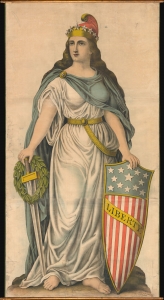
Liberty.
sold
- Digital Map Information
- Suitable for large format printing
- File Size: 188.09 MB
- File Type: ZIP / TIFF
- ICC color profile embedded
- Delivered instantly via download link
A spectacular full-height chromolithograph illustration of Columbia issued c. 1893 by Kurz and Allison, likely for the 1893 Chicago World's Fair or Columbia Exposition. Liberty appears here in full patriotic regalia, with a toga, blue cape, American flag shield, sword, laurel wreath, and Phrygian cap. (more details)
The earliest obtainable specific map of the Great Lakes.
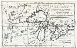
La Louisiana, Parte Settentrionalle, Scoperta sotto la Protettione di Luigi XIV, Re di Francia et Descritta, e Dedicata Dal P. Cosmografo Coronelli, All'Illustriss, et Eccellentiss, S. Zaccaria Bernardi su dell Ecc. S. Francesco.
sold
- Digital Map Information
- Suitable for large format printing
- DPI: 300
- File Size: 6.07 MB
- File Type: ZIP / TIFF
- ICC color profile embedded
- Delivered instantly via download link
This rare 1694 production by Venetian cartographer Vincenzo Coronelli is the earliest and most important obtainable map of the Great Lakes and the headwaters of the Mississippi. Coronelli's map centers on Lake Superior, but covers all five Great Lakes and extends ... (more details)
The earliest obtainable specific map of the Great Lakes.
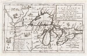
La Louisiana, Parte Settentrionalle, Scoperta sotto la Protettione di Luigi XIV, Re di Francia et Descritta, e Dedicata Dal P. Cosmografo Coronelli, All'Illustriss, et Eccellentiss, S. Zaccaria Bernardi su dell Ecc. S. Francesco.
sold
- Digital Map Information
- Suitable for large format printing
- DPI: 300
- File Size: 5.43 MB
- File Type: ZIP / TIFF
- ICC color profile embedded
- Delivered instantly via download link
This rare 1694 production by Venetian cartographer Vincenzo Coronelli is the earliest and most important obtainable map of the Great Lakes and the headwaters of the Mississippi. Coronelli's map centers on Lake Superior, but covers all five Great Lakes and extends ... (more details)
Essential Canadianum: 'The primary map of this period... influenced the cartography of Canada for the next fifty years.' - Kershaw
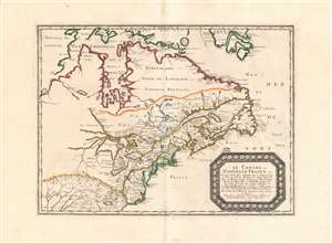
Le Canada, ou Nouvelle France...
sold
- Digital Map Information
- Suitable for large format printing
- DPI: 600
- File Size: 26.16 MB
- File Type: ZIP / TIFF
- ICC color profile embedded
- Delivered instantly via download link
This is Nicolas Sanson's 1656 map of Canada, the Northeast and the Great Lakes, in a superb, untrimmed example. It was among the most influential and important maps of the north part of the Americas to be printed in the 17th century - its depiction of Canada was not superseded until De l'Isle's 1703 Carte du Canada, and it featured the finest depiction of the Great Lakes until the 1687 Coronelli-Nolin. It is among the first printed maps to be informed by the reports of French Jesuit explorers, whose exploration of the Great Lakes region after Champlain's initial explorations was stalled by the 1648 escalation of the Beaver Wars (1603 - 1701) with the Iroquois Confederacy. Following the 1653 pause in the war, Jesuit and French fur traders resumed their push west, gradually revealing the form of the Great Lakes.
The map's treatment of the Arctic waters and Maritime Canada builds on Champlain's basic model, adding place names derived from Dutch and English exploration and preserving Button's explicit northwest passage leading from Button's Bay. (more details)
The map's treatment of the Arctic waters and Maritime Canada builds on Champlain's basic model, adding place names derived from Dutch and English exploration and preserving Button's explicit northwest passage leading from Button's Bay. (more details)
Best early map of the Great Lakes.
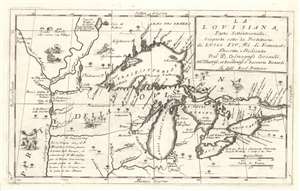
La Louisiana, Parte Settentrionalle, Scoperta sotto la Protettione di Luigi XIV, Re di Francia et Descritta, e Dedicata Dal P. Cosmografo Coronelli, All'Illustriss, et Eccellentiss, S. Zaccaria Bernardi su dell Ecc. S. Francesco.
sold
- Digital Map Information
- Suitable for large format printing
- Full resolution TIFF file
- ICC color profile embedded
- Delivered instantly via download link
This rare 1694 production by Venetian cartographer Vincenzo Coronelli is the earliest and most important obtainable map of the Great Lakes and the headwaters of the Mississippi. Coronelli's map centers on Lake Superior, but covers all five Great Lakes and extends westward as far as the Upper Mississippi River Valley. Cartographically this map is essentially an elaboration upon the 1688 Nolin/Coronelli map, Partie Occidentale du Canada ou de la Nouvelle France. Coronelli was particularly fascinated with the Great Lakes region and this map includes numerous updates and elaborations. (more details)
Rare first edition of Lahontan's highly influential map of the supposedly apocryphal Riviere Longue (Missouri River?)
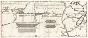
Carte que les Gnacsitares ont Dessine sur / Carte de la Riviere Longue et de quelques Autres qui se Dechargent dans le Grand Fleuve Missisipi.
sold
- Digital Map Information
- Suitable for large format printing
- DPI: 300
- File Size: 7.06 MB
- File Type: ZIP / TIFF
- ICC color profile embedded
- Delivered instantly via download link
A foundational map of extreme importance and influence, this is the rare 1703 first edition of Baron Louis-Armand de Lom d'Arce de Lahontan's, seminal map of the westernmost Great Lakes, the Mississippi River, and an enigmatic tributary river, the Riviere Longue ... (more details)
Rare first edition of Lahontan's highly influential map of the supposedly apocryphal Riviere Longue (Missouri River?)
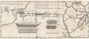
Carte que les Gnacsitares ont Dessine sur / Carte de la Riviere Longue et de quelques Autres qui se Dechargent dans le Grand Fleuve Missisipi.
sold
- Digital Map Information
- Suitable for large format printing
- DPI: 300
- File Size: 8.32 MB
- File Type: ZIP / TIFF
- ICC color profile embedded
- Delivered instantly via download link
A foundational map of extreme importance and influence, this is the rare 1703 first edition of Baron Louis-Armand de Lom d'Arce de Lahontan's, seminal map of the westernmost Great Lakes, the Mississippi River, and an enigmatic tributary river, the Riviere Longue ... (more details)
The Heart of North America from the Finest Globemaker of the 17th Century.
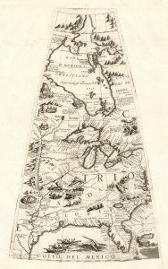
[Untitled Globe Gore of North America from the Tropic of Cancer to the Arctic Circle].
sold
- Digital Map Information
- Suitable for large format printing
- Full resolution TIFF file
- ICC color profile embedded
- Delivered instantly via download link
This is a beautiful 1688 Vincenzo Maria Coronelli globe gore focused on North America east of the Mississippi and west of the Chesapeake, engraved Coronelli's masterpiece 3 1/2 foot globe. The copperplate was adapted in 1697 for inclusion in Coronelli's bound atlases, masked off between the Tropic of Cancer and the Equator to fit book format. The gore covers most of North America east of the Mississippi, spanning from the Tropic of Cancer to the Arctic Circle. Thus, it shows the northern Gulf Coast, Florida, Chesapeake Bay, the Mississippi River (after La Salle), the Great Lakes, and Hudson's Bay. The geography is substantively the same as that on Coronelli's two-sheet America Settentrionale. Although that map bears the date 1688, it was not actually published any earlier than 1690 and it is very probable that the globes represent the earlier appearance of this geographical information. (more details)
Bizarre railroad chromolithograph.
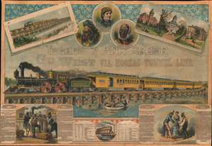
Toledo and Ann Arbor. Go West Via Hoosac Tunnel Line.
sold
- Digital Map Information
- Suitable for large format printing
- File Size: 811.06 MB
- File Type: ZIP / TIFF
- ICC color profile embedded
- Delivered instantly via download link
A striking c. 1870 - 1881 chromolithograph broadside promoting the Toledo and Ann Arbor Railroad. The route, completed in the year this broadside was issued, is promoted with connections to the Hoosac Tunnel Line, itself opened in 1875, and thus to Albany and Boston. The map further includes a lengthy and rambling story featuring 'Uncle Remus', then a popular fictional African-American folk figure. The Toledo and Ann Arbor Railroad apparently contracted the 'Uncle Remus' name for promotional purposes. (more details)
'The primary map of this period... influenced the cartography of Canada for the next fifty years.' - Kershaw

Le Canada, ou Nouvelle France...
sold
- Digital Map Information
- Suitable for large format printing
- Full resolution TIFF file
- ICC color profile embedded
- Delivered instantly via download link
This is Nicolas Sanson's 1656 map of Canada, the Northeast, and the Great Lakes, in an attractive, untrimmed example. It ranks among the most influential and important maps of the north part of the Americas to be printed in the 17th century - its depiction of Canada was not superseded until De l'Isle's 1703 Carte du Canada, and it features the finest depiction of the Great Lakes until the 1687 Coronelli-Nolin. It is among the first printed maps to be informed by the reports of French Jesuit explorers, whose exploration of the Great Lakes region after Champlain's initial explorations was stalled by the 1648 escalation of the Beaver Wars (1603 - 1701) with the Iroquois Confederacy. Following the 1653 pause in the war, Jesuit and French fur traders resumed their push west, gradually revealing the form of the Great Lakes. (more details)
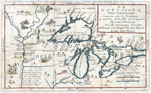
La Louisiana, Parte Settentrionalle, Scoperta sotto la Protettione di Luigi XIV, Re di Francia et Descritta, e Dedicata Dal P. Cosmografo Coronelli, All'Illustriss, et Eccellentiss, S. Zaccaria Bernardi su dell Ecc. S. Francesco.
sold
- Digital Map Information
- Suitable for large format printing
- DPI: 300
- File Size: 6.87 MB
- File Type: ZIP / TIFF
- ICC color profile embedded
- Delivered instantly via download link
This exceedingly rare 1694 map by Vincenzo Coronelli is the most important depiction of the Great Lakes and the headwaters of the Mississippi River to appear in the late 17th century. Covers all five Great Lakes and extends westward as far as the Mississippi ... (more details)
The ephemeral 'Fast Mail', America's first true 'Express Mail Service'.
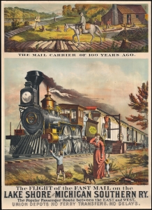
The Flight of the Fast Mail on the Lake Shore and Michigan Southern Ry. The Popular Passenger Route between East and West. Union Depots No Ferry Transfers. No Delays.
sold
- Digital Map Information
- Suitable for large format printing
- File Size: 36.99 MB
- File Type: ZIP / TIFF
- ICC color profile embedded
- Delivered instantly via download link
A spectacular 1875 5-color chromolithograph advertising broadside promoting the 'Fast Mail' route of the Lake Shore and Michigan Southern Railway - this was the first major use of railroads to institute a national 'Express Mail' service. The view contrasts the horse-based mail carrier of 1775 (or literally 1 year prior) to the steam-railroad 'Fast Mail' service. Fast Mail was an ephemeral U.S. postal initiative that utilized the New York Central and Lake Shore and Michigan Southern Railway lines to run an exclusive mail service line capable of moving tons of mail between New York and Chicago - halfway across the country - in just 24 hours. At the time, a ground-breaking achievement. Here, the 'Fast-Mail,' propelled by an impressively rendered steam locomotive, passes through town, hardly slowing as outbound mail is grabbed from a 'mail post' while inbound mail is tossed off the train to a waiting postal worker. (more details)
One of the most influential maps of the Great Lakes to appear in the 18th century.
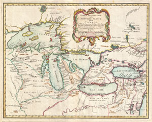
Partie Occidentale de la Nouvelle France ou du Canada.
sold
- Digital Map Information
- Suitable for large format printing
- DPI: 300
- File Size: 13.4 MB
- File Type: ZIP / TIFF
- ICC color profile embedded
- Delivered instantly via download link
A rare and extremely influential 1755 map of the Great Lakes drawn by Jacques Nicholas Bellin. This map, which appeared in the 1755 issue of the Homann Heirs Atlas Major , covers all five of the Great Lakes as well as the adjacent Indian lands and the ... (more details)
Imaginary (but important!) Islands of Lake Superior.
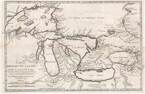
Carte des Lacs du Canada Dresse sur les Manuscrits du Depost des Carts, Plans et Journaux de la Marine et sur le Journal de RP. De Charlevoix.
sold
- Digital Map Information
- Suitable for large format printing
- Full resolution TIFF file
- ICC color profile embedded
- Delivered instantly via download link
This is the 1744 Bellin / Charlevoix map of the Great Lakes, the most accurate map of the Great Lakes to date and the best produced since the De l'Isle map of 1718. It is also the earliest obtainable map, preceded only by a 1742 proof noted by Kershaw, to depict the four fictive islands in Lake Superior (Philippeux, Pontchartrain, Maurepas, and St. Anne) - islands that nonetheless significantly influenced the structuring of post-Revolutionary War borders between British Canada and the fledgling United States. It is also notable for being among the earliest maps to identify Detroit and the Port of Chicago. Bellin's map covers all five Great Lakes and their adjacent drainage systems in considerable detail, noting known fortifications, American Indian villages, missions, and some speculative topography (particularly in Michigan). (more details)
The earliest obtainable example of the first map to introduce four fictional islands in Lake Superior. Islands later used to draw the post-Revolutionary War US-Canada border.
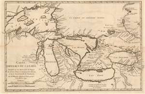
Carte des Lacs du Canada Dresse sur les Manuscrits du Depost des Carts, Plans et Journaux de la Marine et sur le Journal de RP. De Charlevoix.
sold
- Digital Map Information
- Suitable for large format printing
- Full resolution TIFF file
- ICC color profile embedded
- Delivered instantly via download link
This is the 1744 Bellin/ Charlevoix map of the Great Lakes, the most accurate map of the Great Lakes to date and the best to be produced since the De l'Isle map of 1718. It is also the earliest obtainable map, preceded only by a 1742 proof noted by Kershaw, to depict the four fictive islands in Lake Superior (Philippeux, Pontchartrain, Maurepas, and St. Anne) - islands that nonetheless significantly influenced the structuring of post-Revolutionary War borders between British Canada and the fledgling United States. It is also notable for being among the earliest maps to identify Detroit and the Port of Chicago. Bellin's map covers all five Great Lakes and their adjacent drainage systems in considerable detail, noting known fortifications, American Indian villages, missions, and some speculative topography (particularly in Michigan). (more details)
The earliest obtainable example of the first map to introduce four fictional islands in Lake Superior. Islands later used to draw the post-Revolutionary War US-Canada border.
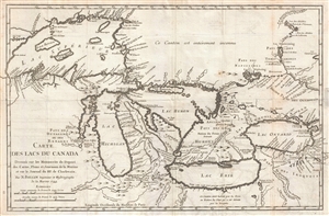
Carte des Lacs du Canada Dresse sur les Manuscrits du Depost des Carts, Plans et Journaux de la Marine et sur le Journal de RP. De Charlevoix.
sold
- Digital Map Information
- Suitable for large format printing
- DPI: 300
- File Size: 5.74 MB
- File Type: ZIP / TIFF
- ICC color profile embedded
- Delivered instantly via download link
An iconic and historically influential 1744 map of the Great Lakes by Jacques-Nicholas Bellin. Possibly Bellin's most important production, this is the earliest obtainable map, preceded only by a 1742 proof noted by Kershaw, to depict the four fictive ... (more details)
The earliest obtainable example of the first map to introduce four fictional islands in Lake Superior. Islands later used to draw post-Revolutionary War US-Canada border.
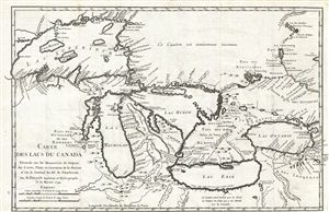
Carte des Lacs du Canada Dresse sur les Manuscrits du Depost des Carts, Plans et Journaux de la Marine et sur le Journal de RP. De Charlevoix.
sold
- Digital Map Information
- Suitable for large format printing
- Full resolution TIFF file
- ICC color profile embedded
- Delivered instantly via download link
An iconic and historically influential 1744 map of the Great Lakes by Jacques-Nicholas Bellin. Possibly Bellin's most important production, this is the earliest obtainable map, preceded only by a 1742 proof noted by Kershaw, to depict the four fictive ... (more details)
The earliest obtainable example of the first map to introduce four fictional islands in Lake Superior. Islands later used to draw the post-Revolutionary War US-Canada border.
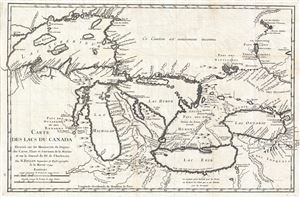
Carte des Lacs du Canada Dresse sur les Manuscrits du Depost des Carts, Plans et Journaux de la Marine et sur le Journal de RP. De Charlevoix.
sold
- Digital Map Information
- Suitable for large format printing
- DPI: 300
- File Size: 6.99 MB
- File Type: ZIP / TIFF
- ICC color profile embedded
- Delivered instantly via download link
An iconic and historically influential 1744 map of the Great Lakes by Jacques-Nicholas Bellin. Possibly Bellin's most important production, this is the earliest obtainable map, preceded only by a 1742 proof noted by Kershaw, to depict the four fictive ... (more details)
Copper Boom on the Keweenaw! Wellge's last work!
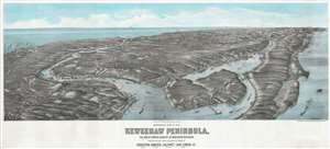
Panoramic View of the Keweenaw Peninsula, The Great Copper Country of Northern Michigan Population near 100,000, including the towns of Houghton, Hancock, Calumet, Lake Linden, Etc.
sold
- Digital Map Information
- Suitable for large format printing
- File Size: 41.33 MB
- File Type: ZIP / TIFF
- ICC color profile embedded
- Delivered instantly via download link
One of only 3 surviving examples of the rare Henry Wellge 1913 bird's-eye view of the Keweenaw Peninsula, Upper Peninsula, Michigan, at the height of the early 20th century copper mining boom. The view looks northeast along the peninsula from a fictive highpoint above Houghton and Portage Lake. Towns are labeled and important buildings noted, including the industrial smelting operations along Torch Lake and Bay. This view was issued by Albert Kennedy Houghton, a bookshop owner in Houghton, shortly before he left town for Minneapolis. (more details)
Big Rapids during its lumber boom five years after incorporation.
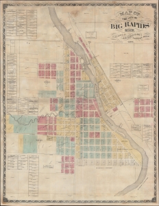
Map of the City of Big Rapids, Mich.
sold
- Digital Map Information
- Suitable for large format printing
- File Size: 167.61 MB
- File Type: ZIP / TIFF
- ICC color profile embedded
- Delivered instantly via download link
This is an 1874 J. S. Bird city map of Big Rapids, Michigan. It captures Big Rapids just 5 years after it was incorporated as a city, during the height of its explosive growth as a logging boomtown. (more details)
Imaginary (but important!) Islands of Lake Superior.
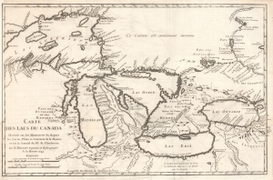
Carte des Lacs du Canada Dresse sur les Manuscrits du Depost des Carts, Plans et Journaux de la Marine et sur le Journal de RP. De Charlevoix.
sold
- Digital Map Information
- Suitable for large format printing
- File Size: 8.57 MB
- File Type: ZIP / TIFF
- ICC color profile embedded
- Delivered instantly via download link
This is the 1744 Bellin / Charlevoix map of the Great Lakes, the most accurate map of the Great Lakes to date and the best produced since the De l'Isle map of 1718. It is also the earliest obtainable map, preceded only by a 1742 proof noted by Kershaw, to depict the four fictive islands in Lake Superior (Philippeux, Pontchartrain, Maurepas, and St. Anne) - islands that nonetheless significantly influenced the structuring of post-Revolutionary War borders between British Canada and the fledgling United States. It is also notable for being among the earliest maps to identify Detroit and the Port of Chicago. Bellin's map covers all five Great Lakes and their adjacent drainage systems in considerable detail, noting known fortifications, American Indian villages, missions, and some speculative topography (particularly in Michigan). (more details)
The Definitive Great Lakes Map of the 18th Century.
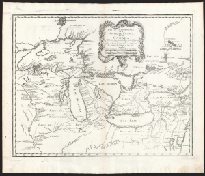
Partie Occidentale de la Nouvelle France ou du Canada.
sold
- Digital Map Information
- Suitable for large format printing
- DPI: 600
- File Size: 43.88 MB
- File Type: ZIP / TIFF
- ICC color profile embedded
- Delivered instantly via download link
An influential map of the Great Lakes, drawn in 1755 by Jacques Nicholas Bellin, and reengraved by Homann Heirs for inclusion in their 1755 Atlas Homannianus Mathematic-Historice Delineatus. It depicts all five of the Great Lakes as well as the adjacent Indian lands and the English colonies of Pennsylvania, New Jersey, and New York. (more details)
Important French and Indian War issue of Bellin's influential Map of the Great Lakes. Probably the most decorative of the series.
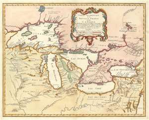
Partie Occidentale de la Nouvelle France ou du Canada.
sold
- Digital Map Information
- Suitable for large format printing
- DPI: 600
- File Size: 22.1 MB
- File Type: ZIP / TIFF
- ICC color profile embedded
- Delivered instantly via download link
A rare and extremely influential 1755 map of the Great Lakes drawn by Jacques Nicholas Bellin. This map, which appeared in the 1755 issue of the Homann Heirs Atlas Major , depicts all five of the Great Lakes as well as the adjacent Indian lands and ... (more details)
Important French and Indian War issue of Bellin's influential Map of the Great Lakes. Probably the most decorative of the series.
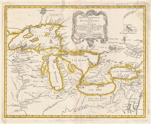
Partie Occidentale de la Nouvelle France ou du Canada.
sold
- Digital Map Information
- Suitable for large format printing
- DPI: 300
- File Size: 11.3 MB
- File Type: ZIP / TIFF
- ICC color profile embedded
- Delivered instantly via download link
A rare and extremely influential 1755 map of the Great Lakes drawn by Jacques Nicholas Bellin. This map, which appeared in the 1755 issue of the Homann Heirs Atlas Major , depicts all five of the Great Lakes as well as the adjacent Indian lands and ... (more details)
Guide to new life in Michigan.
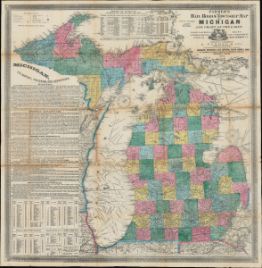
Farmer's Railroad and Township Map of Michigan and Chart of the Lakes.
sold
- Digital Map Information
- Suitable for large format printing
- Full resolution TIFF file
- ICC color profile embedded
- Delivered instantly via download link
This is Silas Farmer's important 1864 railroad and township map of Michigan. Farmer's map appeared during a period when Michigan was a hotspot for immigration and settlement. Both father John Farmer and his son Silas Farmer were local Michigan cartographers who worked assiduously with contemporaneous local governments and surveyors to keep their maps up-to-date, publishing editions annually and sometimes biannually. Such maps were essential for emigrants, both for travel and for life planning. (more details)
Definitive Great Lakes Map of the 18th Century.
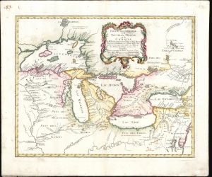
Partie Occidentale de la Nouvelle France ou du Canada.
sold
- Digital Map Information
- Suitable for large format printing
- File Size: 24.47 MB
- File Type: ZIP / TIFF
- ICC color profile embedded
- Delivered instantly via download link
An influential map of the Great Lakes, drawn in 1755 by Jacques Nicholas Bellin and reengraved by Homann Heirs for the 1755 Atlas Homannianus Mathematic-Historice Delineatus. It depicts the five Great Lakes, as well as the adjacent Indian lands and the English colonies of Pennsylvania, New Jersey, and New York. Due to the reach of the Homann Heirs firm, this is one of the most iconic early maps of the Great Lakes. (more details)
A rare painted view of of Detroit, Michigan as it would have appeared in 1818.
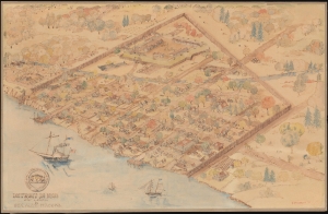
Detroit in 1818 after a sketch by Gen. Alex. Macomb.
sold
- Digital Map Information
- Suitable for large format printing
- File Size: 9.07 MB
- File Type: ZIP / TIFF
- ICC color profile embedded
- Delivered instantly via download link
This is a 1931 C. P. Mithoff pictorial painting view and map of Detroit, Michigan, as it appeared in 1818. The view overlooks Detroit from the northwest across the Detroit River. Surrounded by a stockade, Fort Shelby occupies the northernmost portion of the fortified area and is illustrated with several buildings and a flagpole. Numerous streets appear and are identified, including Shelter Street, Woodbridge Street, Griswold Street, Jefferson Avenue, Woodward Avenue, and Randolph Street. Cass Street and Brush Street are outside the stockade, and Jefferson Avenue and Woodward Avenue continue past the stockade. The soldier's burial ground is illustrated along the stockade's northwest wall. Ninety-five locations both inside and outside the stockade are labeled numerically, although unfortunately the corresponding index is not present. (more details)
Guide to new life in Michigan.
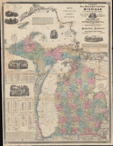
Farmer's Railroad and Township Map of Michigan and Chart of the Lakes.
sold
- Digital Map Information
- Suitable for large format printing
- File Size: 105.12 MB
- File Type: ZIP / TIFF
- ICC color profile embedded
- Delivered instantly via download link
This is an 1868 Silas Farmer railroad and township map of Michigan. Farmer's map appeared during a period when Michigan was a hotspot for emigration and settlement. Both father John Farmer and his son Silas Farmer worked assiduously to keep their maps updated, publishing editions annually and sometimes biannually. Such maps were essential for emigrants not only for travel, but also for planning their new life. (more details)
The early days of Minnesota Territory.
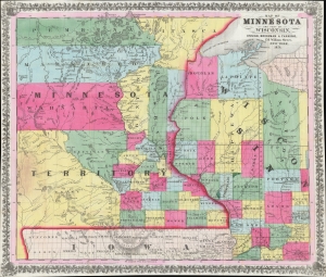
Map of Minnesota and Part of Wisconsin.
sold
- Digital Map Information
- Suitable for large format printing
- Full resolution TIFF file
- ICC color profile embedded
- Delivered instantly via download link
A stunning 1856 Ensign, Bridgman, and Fanning map of Minnesota Territory representing the early settlement of Minnesota. This map illustrates the beginning of the settlement plan for Minnesota proposed by Jonathan Carver in his 1778 Travels. When this map was issued, life in Minnesota was characterized by harsh living conditions and frontier lawlessness dominated by American Indian relations and the fur trade. (more details)
Michigan Land Rush.
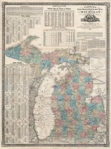
Farmer's Railroad and Township Map of Michigan and Chart of the Lakes.
sold
- Digital Map Information
- Suitable for large format printing
- File Size: 53.38 MB
- File Type: ZIP / TIFF
- ICC color profile embedded
- Delivered instantly via download link
This is an 1868 Silas Farmer railroad and township map of Michigan. Farmer's maps appeared as the federal government was privatizing over 26 million acres of Michigan land for emigration and settlement. With a veritable land rush in progress, both father, John Farmer, and son, Silas Farmer, worked assiduously to keep their maps updated, publishing editions annually and sometimes biannually. Such maps were essential for emigrants, not only for travel, but also to plan frontier life. (more details)
This primary map of Canada emphasized the importance of the river trading routes.' -Kershaw
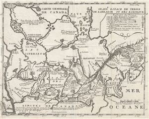
Carte Generale de Canada.
sold
- Digital Map Information
- Suitable for large format printing
- Full resolution TIFF file
- ICC color profile embedded
- Delivered instantly via download link
A fine example of Lahontan's scarce and important 1715 map of the Great Lakes, Canada, and the Upper Mississippi. Lahontan's map covers from the Mississippi River eastward to the mouth of the St. Lawrence and the Atlantic Ocean, and from the Hudson ... (more details)
An ephemeral railroad.
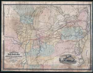
A Section of J. Sage and Sons New and Reliable Rail Road Map comprising all the Rail Roads in operation in the Middle and Western States with their stations and distances.
sold
- Digital Map Information
- Suitable for large format printing
- File Size: 30.49 MB
- File Type: ZIP / TIFF
- ICC color profile embedded
- Delivered instantly via download link
A rare 1858 wall format railroad map issued by J. Sage and Sons. The map's coverage extends from the Mid-Atlantic seaboard west to Missouri and Iowa, inclusive of all of the Great Lakes. It extends south as far as Tennessee and the Outer Banks. A high level of detail is present with regard to rail lines, including many stopping points throughout. Otherwise, the cartographers took a minimalist approach and areas underserved by the railroad networks are generally left blank. Red overprinting emphasizes the Bellefontaine, Terre Haute, and St. Louis Railroad, an extensive network with coverage from New York City to St. Louis. An inset featuring an engraving of the Indianapolis Central Terminal occupies the lower right. (more details)