
Attractive mid-century tourist map of the Balearic Island of Mallorca or Majorca.
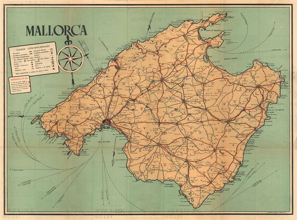
Mallorca / Mapa de la Isla de Mallorca.
sold
- Digital Map Information
- Suitable for large format printing
- File Size: 24.81 MB
- File Type: ZIP / TIFF
- ICC color profile embedded
- Delivered instantly via download link
An attractive 1949 tourist map of the Balearic island of Mallorca / Majorca, Spain. The map covers the beautiful island in full, illustrating all roadways, railroad lines, towns and villages, historical sites, mileage, and more. On the recto (back) there are various advertisements for tourism related businesses. (more details)
One of the most beautiful, important, and enduring maps of Manhattan ever published.

Topographical Map of the City of New York showing original water courses and made land.
sold
- Digital Map Information
- Suitable for large format printing
- File Size: 92.32 MB
- File Type: ZIP / TIFF
- ICC color profile embedded
- Delivered instantly via download link
This is Egbert L. Viele's 1865 topography and waterways map of Manhattan, one of the scarcest, most important, and most enduring maps of New York City ever published. Covering the entirety of Manhattan Island, Viele's map details the canals, swamps, rivers, ditches, ponds, meadows, and drainage basins of Manhattan as they existed prior to the city's urban development. A version of the Viele map remains in use today by architects and contractors who need to be certain they are not building over underground rivers and swamps that may destabilize a new construction's foundation. (more details)
The first official map of Cook's first voyage - the best map of the Australia, the South Pacific, and New Zealand of it time.
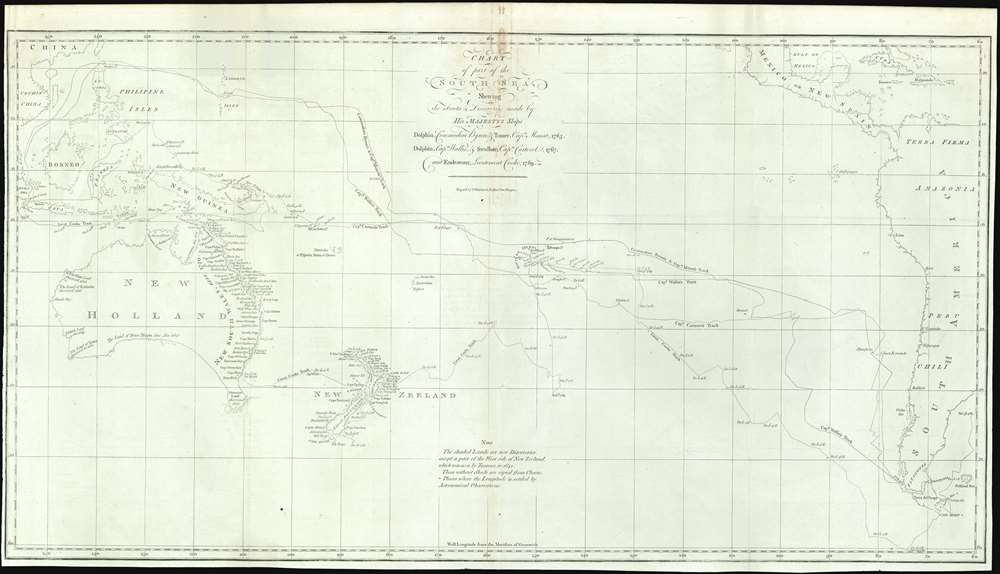
Chart of part of the South Sea, Shewing the Tracts and Discoveries made by His Majesty's Ships Dolphin, Commodore Byron, and Tamer, Captn. Mouat, 1765. Dolphin, Captn., Wallis, and Swallow, Captn. Carteret, 1767. And Endeavour, Lieutenant Cooke, 1769.
sold
- Digital Map Information
- Suitable for large format printing
- File Size: 18.3 MB
- File Type: ZIP / TIFF
- ICC color profile embedded
- Delivered instantly via download link
This is a rare 1773 map of the South Pacific issued to illustrates English voyages of exploration in this region between 1765 and 1769, including the voyages of John Byron (1723 - 1786), Samuel Wallis (1728 - 1795), Philip Carteret (1733 - 1796), and James Cook (1728 - 1779). At the time of publication this was the most accurate extant map of this region, unveiling a wealth of new information to curious Europeans. Coverage extends from Sumatra to South America, and from Baja California and Taiwan to Tierra del Fuego, including all of Australia, Polynesia, New Zealand, the Philippines, Melanesia, and eastern Indonesia. Tasmania or Van Diemen's Land is notably attached to the Australian mainland. Tracks drawn from ship's original logs detail with precision the routes taken by Commodore Byron and Captain Mouat (1765), Captain Carteret (1767), Captain Wallis (1767), and Lieutenant James Cook (1769). (more details)
Illustrates Brazil during the ill fated Dutch attempt to wrest Brazil from Portuguese control.
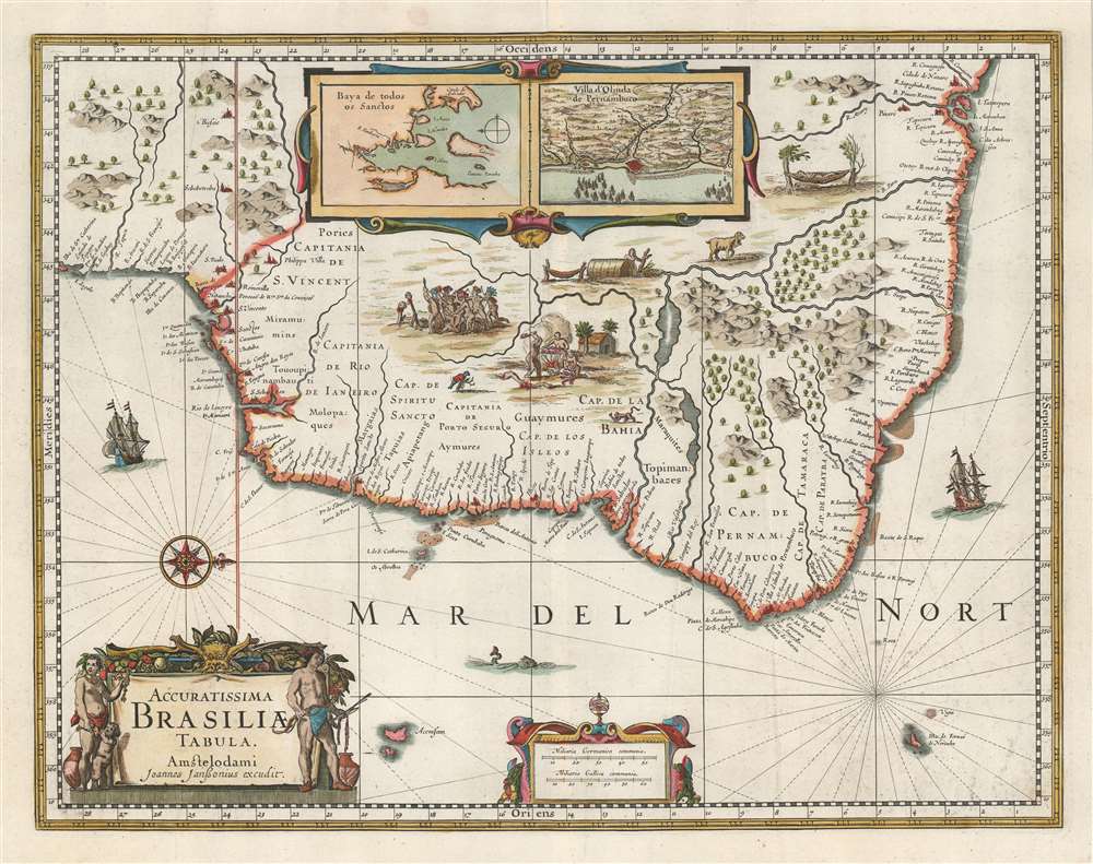
Accuratissima Brasiliae Tabula.
sold
- Digital Map Information
- Suitable for large format printing
- DPI: 600
- File Size: 17.24 MB
- File Type: ZIP / TIFF
- ICC color profile embedded
- Delivered instantly via download link
Portuguese War and Dutch hegemony in Brazil. The map emerged from a short lived Dutch effort spearheaded by the Dutch West India Company (WIC), to take over Brazil and the Portuguese sugar trade. Oriented to the west, as one would approach Brazilian coasts from the sea, the map covers Sao Paulo in the south to Cidade de Nazare and São Luís in the north. The exterior is dotted with cities, ports and large navigable rivers, lending an aura of prosperity to the region. The interior, by contrast, exhibits grizzly vignette scenes of cannibalism, beheading, and tribal warfare, along with a few exotic animals. Inset maps at top center detail 'Baya de Todos os Sanctos' and 'Villa d'Olinda de Pernambuco,' both then under Dutch governance. (more details)
Scarcce example of Richard Q. Yardley's work.
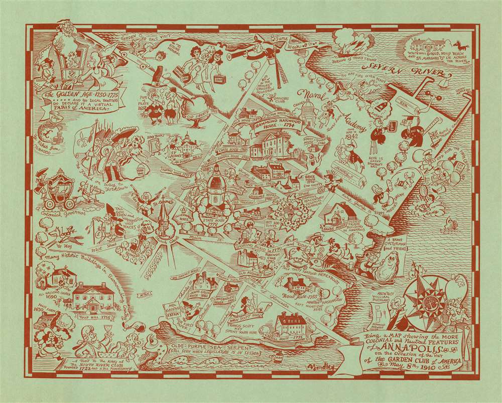
Being a MAP showing the MORE COLONIAL and Nautical FEATURES of ANNAPOLIS on the Occasion of the visit of the GARDEN CLUB of AMERICA.
sold
- Digital Map Information
- Suitable for large format printing
- File Size: 28.84 MB
- File Type: ZIP / TIFF
- ICC color profile embedded
- Delivered instantly via download link
A charming Richard Q. Yardley pictorial map of Annapolis, Maryland issued in 1940 by the Garden Club of America to commemorate their visit to said city. Printed with striking red ink on blue-green paper, this mapis oriented generally to the north. The map is centered on the State house, constructed in 1772, with the United States Naval Academy occupying the upper right quadrant. Local characters, historical buildings, and historian annotations appear throughout in Yardley's inimitable style. (more details)
Giant blueback working nautical chart of the Indian Ocean with in manuscript navigational notes.
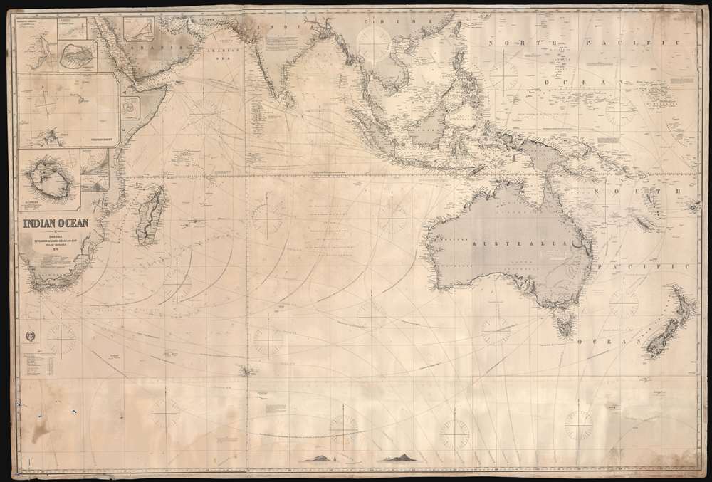
Indian Ocean.
sold
- Digital Map Information
- Suitable for large format printing
- Full resolution TIFF file
- ICC color profile embedded
- Delivered instantly via download link
This is a gigantic 1874 James Imray and Son blueback working nautical chart or maritime map of the Indian Ocean covered in manuscript notations. The map depicts the world from East Africa to Fiji and from Taiwan and the Persian Gulf to 60 degrees south latitude. Manuscript pencil notations trace at least three, possibly four, voyages across the Indian Ocean. These notations mark the vessel's location on its trip across the ocean and notes what is most likely the day of the expedition. Apart from these four voyages, numerous routes between various points throughout the region are also illustrated, with a particular concentration running from the Gulf of Aden to the East Indies, frequented trade routes between England and the Netherlands and these colonies rich in natural resources. Myriad locations are identified throughout, particularly along the coastlines and small islands making up parts of archipelagos situated throughout the Pacific Ocean and the China Sea. Eight inset maps are situated on the map's left side and illustrate Cargados Carajos, Coetivy, Rodrigues, Wood Island, Farquhar Passage, Tromelin, Réunion, and the cities of Saint Paul and Saint Denis on Réunion. (more details)
Highlights Florida's state parks and historic memorials.

Visit Florida State Parks and Historic Memorials.
sold
- Digital Map Information
- Suitable for large format printing
- File Size: 39.06 MB
- File Type: ZIP / TIFF
- ICC color profile embedded
- Delivered instantly via download link
This is a c. 1970 pictorial tourist map of Florida. Ringed by photographs of Florida attractions and activities, the map depicts the state from Alabama to the Atlantic Ocean and from Georgia and Alabama to Key West. Pictorial vignettes highlight state parks and historic memorials throughout the state, including the Florida Caverns, Manatee Springs, Turtle Mound, and Collier Seminole. A key to the left of Key West notes that four different symbols are used when marking sites around the state: circles mark parks that are in operation, squares mark partially developed parks, and triangles note undeveloped parks. Diamonds denote historic landmarks. (more details)
The finest commercial map of Wyoming Territory issued at the height of the Wyoming Cattle Boom.

Holt's New Map of Wyoming.
sold
- Digital Map Information
- Suitable for large format printing
- File Size: 85.59 MB
- File Type: ZIP / TIFF
- ICC color profile embedded
- Delivered instantly via download link
A near flawless 1884 second edition of Holt's important and rare separate-issue map of Wyoming Territory. Issued at the height of the Wyoming Cattle Boom (Bubble), Holt's map is considered to be one of the finest maps of Wyoming and the earliest commercially published map to show the territory in significant detail. Throughout, the level of attention to accuracy is extraordinary, with individual residences, ranches, forts, Indian reservations, mining districts, resources, railroads, stage roads, and regular roads named. To the left and right the title, vignettes of cattle and a meat processing plant pay homage to the Wyoming Territory's then bourgeoning cattle industry. In the upper left corner of the map, Yellowstone National Park is mapped with care. (more details)
A previously unrecorded edition of a city plan of Atlanta, Georgia.

Map of Atlanta Georgia.
sold
- Digital Map Information
- Suitable for large format printing
- File Size: 55.92 MB
- File Type: ZIP / TIFF
- ICC color profile embedded
- Delivered instantly via download link
This is a previously unrecorded 1924 Lester Book and Stationery Company city map or plan of Atlanta, Georgia. The map depicts the city from Westview Cemetery to Druid Hills and from Ansley Park to Forrest Park and Fort McPherson. Meant as a driving aid for people trying to make their way around Atlanta, most streets in the city are illustrated and labeled. Train stations, universities, parks, and cemeteries are identified as are numerous neighborhoods around the city. Concentric circles radiate out from the city center, marking every location's distance from the center of town. An alphabetical street index, situated along the bottom of the map, provides the grid location of every street in Atlanta. Published during the 'Roaring Twenties', the Lester Book and Stationery Company must have been trying to benefit from the economic prosperity of the decade and the proliferation of automobiles in the United States. Over the course of the 1920s, 26 million cars were sold in the United States. As paved roads became more and more common, driving became easier and easier, more people bought cars, and prices fell. (more details)
A striking map of northern Europe speculating on where the Allies would invade in the spring of 1944.

Invasionland.
sold
- Digital Map Information
- Suitable for large format printing
- File Size: 78.3 MB
- File Type: ZIP / TIFF
- ICC color profile embedded
- Delivered instantly via download link
Perhaps the worst best-kept secret of World War II, by the spring of 1944 everyone on the planet was waiting for the long-awaited Allied invasion of Northern Europe. This map, created by Robert M. Chapin, Jr., encapsulates that anticipation, speculating where American and British forces would land along the northern coast of Europe. Here, numerous locations along the coast are identified, including Calais (which was believed to be the most likely location for the invasion), Dunkirk (the site of the storied evacuation of British and French troops), Cherbourg, Brest, and even Wilhelmshaven, the German submarine base. The thick red lines indicate major railways, illustrating where it would be easiest for the Germans to quickly move their forces to repel the invasion. The swastikas inscribed in red circles mark 'command forts' constructed by Rommel to help repel the expected invasion. (more details)
Beautiful early map of Africa showing the mythical Kingdom of Prester John.
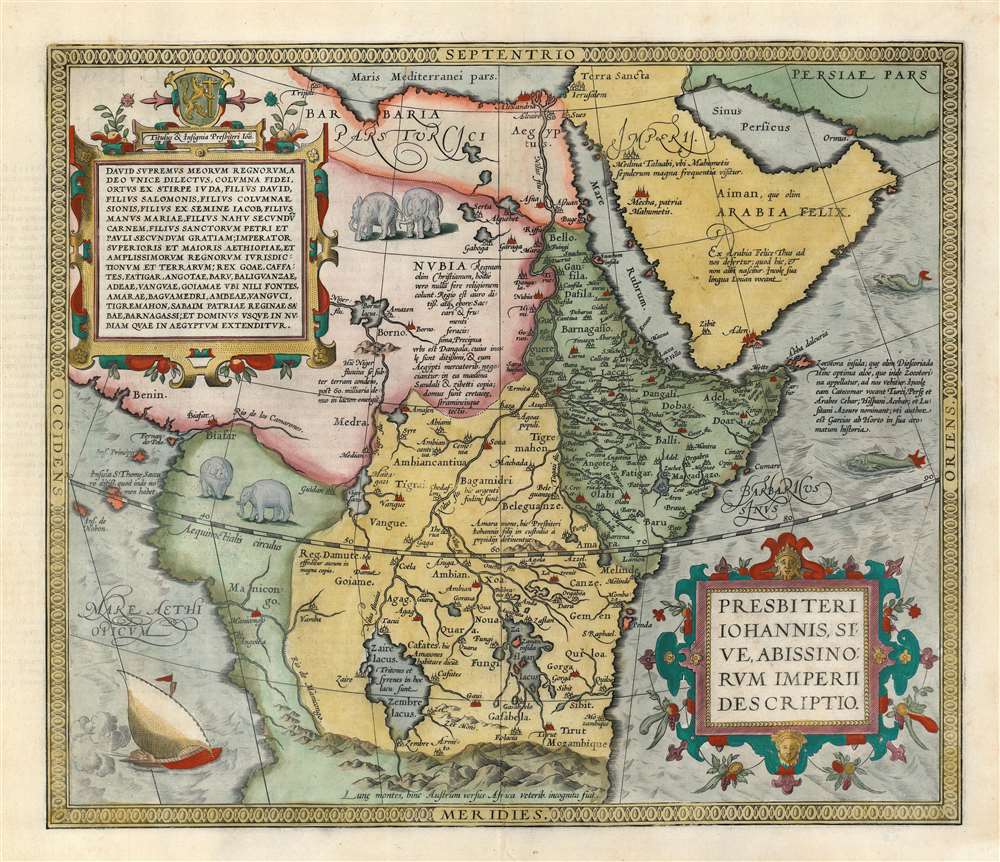
Presbiteri Iohannis, Sive, Abissionrum Imperii Descriptio.
sold
- Digital Map Information
- Suitable for large format printing
- DPI: 600
- File Size: 20.56 MB
- File Type: ZIP / TIFF
- ICC color profile embedded
- Delivered instantly via download link
A fascinating map of central Africa issued by Abraham Ortelius in 1598. The map covers from the Bight of Benin to the Indian Ocean and from Arabia and the Red Sea to Mozambique. It includes two decorative cartouches as well as stylized images of African elephants. While the African coast exhibits considerable advances over earlier maps of the region, the interior of Africa exhibits a cartography primarily based on the literature of antiquity and little changed from the days of Ptolemy. Superimposed on these speculative lands is the legendary Kingdom of Prester John (Presbiteri Ioannis) – a persistent and popular figure in European folklore. Cartographically the map is derived from Gastaldi's 1564 eight-sheet wall map of Africa. (more details)
Pictorial Map depicting Chicago at the time of its incorporation in 1833.
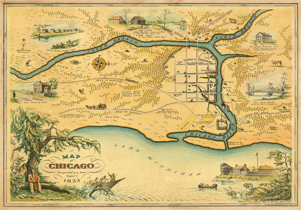
A Map of Chicago Incorporated as a Town August 5 1833.
sold
- Digital Map Information
- Suitable for large format printing
- File Size: 37.83 MB
- File Type: ZIP / TIFF
- ICC color profile embedded
- Delivered instantly via download link
This is a beautiful 1933 pictorial map of Chicago issued by Walter Conley and O. E. Stelzer issued to commemorate the centennial of the founding of Chicago in 1833. Oriented with north to the right, it depicts Chicago at the time of its incorporation in 1833, when ... (more details)
Possibly the first published map of Prospect Park.

Design for Prospect Park as Proposed to be Laid Out for The City of Brooklyn.
sold
- Digital Map Information
- Suitable for large format printing
- File Size: 14.64 MB
- File Type: ZIP / TIFF
- ICC color profile embedded
- Delivered instantly via download link
A rare 1868 first edition of Vaux and Olmsted's map of Prospect Park, Brooklyn. Issued just months after its October 1867 completion, this is one of the first published maps to depict the design of Prospect Park. The map depicts the park as a whole and includes pathways, lakes, buildings, individual trees, rocks, and elevation measurements. The streets and avenues surrounding the park are also noted. (more details)
Art Deco airline advertising sign.

B.O.A.C. Speedbird Routes Across the World.
sold
This is a wonderful c. 1960s art-deco pictorial map made into a fan to advertise the 'Speedbird' routes of the British Overseas Airways Corporation or B.O.A.C. He paper map consists of stylized map of the world centered on London. Routes, appearing in white extend across the pacific, throughout Africa and Asia, and extending into Australia. Vignette illustrations throughout illustrate cultural icons such as Blackfriars Bridge and the Statue of Liberty, objects of natural wonder such as Mount Fuji and elephants, and a Masai warrior in Africa. (more details)
Published soon after the French regained possession of the island after the Seven Years' War.

Carte de l'Isle de Sainte Lucie.
sold
- Digital Map Information
- Suitable for large format printing
- DPI: 600
- File Size: 55.95 MB
- File Type: ZIP / TIFF
- ICC color profile embedded
- Delivered instantly via download link
This is a 1763 Jacques-Nicolas Bellin map of the island of Saint Lucia. Created soon after the end of the Seven Years' War (which is known as the French and Indian War in the United States), the map depicts the entirety of the island in stunning detail, illustrating the mountainous terrain that is also covered in forests. Numerous coastal locations are labeled, including several harbors that are marked by anchors. Three inset maps are included along the top border illustrating the Port of Carenage (today the town of Castries), the Cul de Sac des Roseaux (a bay along the island's western coastline), and part of the island's western coast from the Grand Islet to Carenage. (more details)
Features a central view of the captured Confederate capital of Richmond and maps of thirty Civil War battles.

In Commemoration of the Glorious Victories of the 3rd and 9th of April 1865.
sold
- Digital Map Information
- Suitable for large format printing
- File Size: 19.22 MB
- File Type: ZIP / TIFF
- ICC color profile embedded
- Delivered instantly via download link
This is an 1865 Charles Magnus view of Richmond, Virginia at the end the American Civil War. The view commemorates the Union occupation of Richmond, the Confederate capital, on April 3, 1865 and the subsequent surrender of Confederate General Robert E. Lee to Union General Ulysses S. Grant on April 9. Richmond is illustrated as seen from the south bank of the James River with the Confederate capital building prominently illustrated. The Union Army appears in the foreground. Soldiers are shown marching in formation while officers and cavalrymen ride on horseback. A handful of cannons are included on the left.
The whole is framed by a series of medallions illustrating Civil War battles and five portraits of Union generals. Lieutenant General Ulysses S. Grant, commander of all Union forces at the end of the war, is prominently featured at bottom center. To his left is Major General Philip Sheridan and to his right, Major General Hugh Kilpatrick. A portrait of Major General William Tecumseh Sherman, known for capturing Atlanta and his March to the Sea, occupies the top left corner while a portrait of Major General George Henry Thomas is situated in the upper right. Between these illustrious commanders are thirty smaller circular medallions highlighting various engagements of the war, including the Capture of Atlanta, the Battle of Five Forks, the siege at Petersburg, Virginia, the Battle of Cold Harbor, the Battle of Spotsylvania Court House, and the surrender at Appomattox. (more details)
The whole is framed by a series of medallions illustrating Civil War battles and five portraits of Union generals. Lieutenant General Ulysses S. Grant, commander of all Union forces at the end of the war, is prominently featured at bottom center. To his left is Major General Philip Sheridan and to his right, Major General Hugh Kilpatrick. A portrait of Major General William Tecumseh Sherman, known for capturing Atlanta and his March to the Sea, occupies the top left corner while a portrait of Major General George Henry Thomas is situated in the upper right. Between these illustrious commanders are thirty smaller circular medallions highlighting various engagements of the war, including the Capture of Atlanta, the Battle of Five Forks, the siege at Petersburg, Virginia, the Battle of Cold Harbor, the Battle of Spotsylvania Court House, and the surrender at Appomattox. (more details)
Old color first edition of Braun and Hogenberg's Dutch Golden Age view of Amsterdam.

Amstelredamvm, nobile inferioris Germaniae oppidum ad recipiendos ex omnib. mundi partibus, mercatores, recenter natum genus hominum incolit mercimonijs deditum quae quidem, tum blanda populi comitate, ac sedula diligentiqu[ue] industria : tum portus comoditate permagna, vsq[ue]adeo incrementa sumpserunt vt vix vllum mercaturae genus excogitari possit quod heic non exerceatur : hinc fit vt opum lucrique cupiditas, ex remotissimis etiam terris, negotiatores, in hanc ciuitate inuitet qui varia hinc bona et maximè rem frumentaria in Brabantiam caeteraq[ue] longè dissita totius vniuersi loca, transferentes : ingentes ex eiuscemodi commertio opes consequuntur.
sold
- Digital Map Information
- Suitable for large format printing
- DPI: 600
- File Size: 25.26 MB
- File Type: ZIP / TIFF
- ICC color profile embedded
- Delivered instantly via download link
An attractive first edition old color example of George Braun and Franz Hogenberg's 1572 city view and map of Amsterdam. The map, presented in bird's-eye view form, looks on Dutch Golden Age Amsterdam from the northeast. On the left side the map illustrates the elaborate damming and redirection of the Amstel River into Amsterdam's famous canal network. Ships line the canals and fill the Zuiderzee both on the inside and outside of Amsterdam's defensive seawall - suggestive of Amsterdam's enormous commercial prosperity. At center, the old town hall (Stadhuis, 21) and the neighboring Nieue Kerk (23), are recognizable. In the lower right, at the edge of the map, is the gallows field with a total of 11 unfortunates. (more details)
A topographic map of 'The Roof of the World' - Nepal and the Himalayas.

नेपाल प्राकृतिक. [Nepal Natural].
sold
A 1980 New Delhi Map Company topographic map of Nepal, a country often called 'The Roof of the World.' Depicting the entirety of Nepal, the map employs color coding to illustrate the dramatic Himalayan terrain. Ten different colors are used to differentiate between ranges in elevation, starting below 150 meters (500 feet) to 6,000 meters (19,700 feet). Some mountain peaks are labeled with elevations provided in meters.
Cities, towns, and villages are noted throughout. Roads, both paved and unpaved, are illustrated as well, with solid red lines representing both highways and paved roads and red dashed lines tracing unpaved roads. A key detailing the notations used for elevations, borders, cities, roads, and rivers is situated in the lower left quadrant. A political map of Nepal is also located in the lower left quadrant and depicts the country's fourteen Administrative Zones, a system which was abandoned in 2015 when Nepal reorganized into seven provinces. Each administrative zone is labeled and shaded a different color to allow for easy differentiation. (more details)
Cities, towns, and villages are noted throughout. Roads, both paved and unpaved, are illustrated as well, with solid red lines representing both highways and paved roads and red dashed lines tracing unpaved roads. A key detailing the notations used for elevations, borders, cities, roads, and rivers is situated in the lower left quadrant. A political map of Nepal is also located in the lower left quadrant and depicts the country's fourteen Administrative Zones, a system which was abandoned in 2015 when Nepal reorganized into seven provinces. Each administrative zone is labeled and shaded a different color to allow for easy differentiation. (more details)
A pictorial map of Kathmandu, Nepal featuring illustrations of some of the city's World Heritage sites.

Kathmandu Patan Kantipur Lalitpur.
sold
This is a 1987 Madhab Lal Maharjan pictorial city map or plan of Kathmandu and Patan (Lalitpur), Nepal. The map depicts the cities from the ring road and Tribhuvan University to Tribhuvan International Airport and from Budhanilkantha to Dakshinkali. Major roads in both Kathmandu and Patan are illustrated and labeled with solid lines indicating blacktopped roads and dashed lines symbolizing dirt roads. Several locations in and around the city are illustrated in profile, including the Royal Palace, the Royal Guest House, Pashupatinath Temple, the Singha Durbar Secretarial Building, the National Museum, the Boudhanath Stupa, and the Swayambhunath Temple. 187 other locations are numerically identified and correspond with an index situated along the right border, such as airline offices, banks, booksellers, embassies, hospitals, hotels, restaurants, and movie theaters. Mountaineering businesses are also listed. Maharjan's bookshop, Himalayan Book Sellers, is labeled in block letters not far below the Royal Palace. An inset map of Kathmandu Durbar Square is situated in the upper left corner in which a handful of locations are labeled and another nine are indexed numerically. Another inset map, this one depicting Patan Durbar Square, is included in the lower right corner. Three locations are labeled and another eleven are numerically indexed. A photographic view of Kathmandu is situated below the map. (more details)
When you want a pointer…'

Mark! When you want a Pointer regarding your western trip…
sold
- Digital Map Information
- Suitable for large format printing
- File Size: 3.95 MB
- File Type: ZIP / TIFF
- ICC color profile embedded
- Delivered instantly via download link
An utterly charming 1896 lithograph pictorial map issued to promote travel to the Pacific Northwest via the Northern Pacific Railway. This map was issued in 1896 by Charles S. Fee, general passenger agent for the Northern Pacific Railway. It covers the western part of the United States roughly from the Great Lakes to the Pacific. Superimposed upon the map is the image of an English Pointer dog in classic 'pointer' pose. The dog's head, spine, and tail illustrate the course of the Northern Pacific Railway from Duluth, Minnesota to Olympia, Washington. Promotional copy overlaying the map reads,
Mark! When you want a Pointer regarding your western trip call on your nearest ticket agent or district passenger agent on the Northern Pacific Railway Co. or address Chas. S. Fee General Passenger Agent St. Paul, Minn.A list of passenger agents is printed on the verso. (more details)