
Map that reveals the lost Indiana-Michigan border!

Plat of the northern boundary line of the state of Indiana : surveyed in conformity to the Act of Contress, 'To authorize the President of the United States to ascertain and designate the northern boundary of the state of Indiana: passed March 2nd, 1827.
sold
- Digital Map Information
- Suitable for large format printing
- DPI: 300
- File Size: 9.59 MB
- File Type: ZIP / TIFF
- ICC color profile embedded
- Delivered instantly via download link
This is a scarce 1827 Eleazer P. Kendrick map drawn to determine the Indiana-Michigan border. The map extends from Lake Michigan to Ohio and covers territory approximately 20 miles from north to south. When Michigan territory was established in 1805 its southern ... (more details)
Annand map promoting the 1939 New York World's Fair.
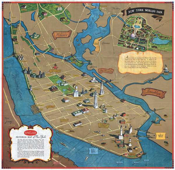
Sinclair Pictorial Map of New York. / New York World's Fair.
sold
- Digital Map Information
- Suitable for large format printing
- File Size: 21.01 MB
- File Type: ZIP / TIFF
- ICC color profile embedded
- Delivered instantly via download link
This is a rare pictorial map of New York City drawn in 1939 by Georg Annand for Sinclair Oil to promote the 1939 New York World's Fair. The map takes the form of a perspective view of New York City with Flushing and the Bronx retreating into the distance and ... (more details)
Emphasizes America's rearmament and the revitalization of the economy.
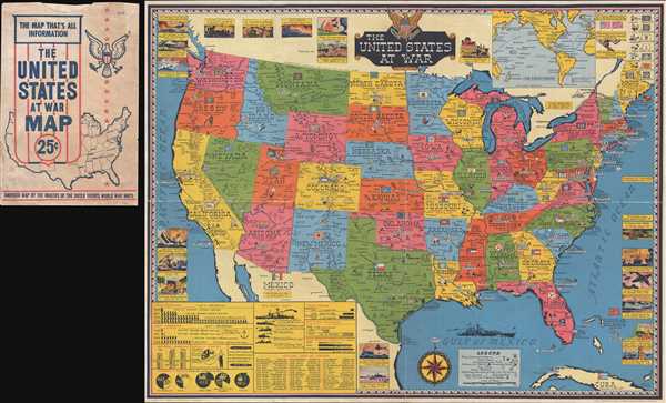
The United States at War.
sold
- Digital Map Information
- Suitable for large format printing
- File Size: 14.98 MB
- File Type: ZIP / TIFF
- ICC color profile embedded
- Delivered instantly via download link
This is a 1943 Stanley Francis Turner map of the United States during World War II. Depicting from the Pacific Ocean to the Atlantic Ocean and from Canada to Mexico, this map emphasizes the burgeoning industrial strength of the United States and its effect on ... (more details)
Map of a short-lived Scottish colony in Panama whose failure led to the creation of the United Kingdom.

The Scots settlement in America called New Caledonia, A.D. 1699. Lat. 8°-30ʹ north.
sold
- Digital Map Information
- Suitable for large format printing
- DPI: 300
- File Size: 2.16 MB
- File Type: ZIP / TIFF
- ICC color profile embedded
- Delivered instantly via download link
A fascinating map with huge political ramifications, this is Herman Moll's 1729 map of the short-lived Scottish colony in Panama, New Caledonia. New Caledonia was situated on the south eastern coast of modern day Panama in the Gulf of Darien, near what is ... (more details)
A pictorial map of the New Orleans French quarter by Carnival costume designer Louis Andrews and socialite Lucile Gillican.

Le Vieux Carre de la Nouvelle Orleans Over a Span of Many Years.
sold
- Digital Map Information
- Suitable for large format printing
- File Size: 7.72 MB
- File Type: ZIP / TIFF
- ICC color profile embedded
- Delivered instantly via download link
This is a 1929 prospectus edition of a pictorial map of New Orleans issued by Lucile Gillican and Louis Elizabeth Andrews Fischer (1901-1974). The map depicts the New Orleans French Quarter or Vieux Carré highlighting historic buildings and New Orleans ... (more details)
Highly decorative map illustrating the sources of the world's spices.

McCormick's Map of the World.
sold
- Digital Map Information
- Suitable for large format printing
- File Size: 30.56 MB
- File Type: ZIP / TIFF
- ICC color profile embedded
- Delivered instantly via download link
This is a promotional map issued for the McCormick Schilling Spice company. The map covers the entire world on a double-hemisphere projection. A wealth of information is offered through ranging from the locations where various spices in the McCormick ... (more details)
Stunning restrike of the first edition copper plate nautical chart of New York Bay and Harbor.

Map of New-York Bay and Harbor and the Environs.
sold
- Digital Map Information
- Suitable for large format printing
- File Size: 24.21 MB
- File Type: ZIP / TIFF
- ICC color profile embedded
- Delivered instantly via download link
This is a c.1920s restrike of the first edition 1845 United States Coast Survey nautical chart or maritime map of New York Bay and Harbor and its environs. Depicting the region from Newark to South Oyster Bay and from the City of New York to Sandy ... (more details)
Open-top bus outings from Paris!
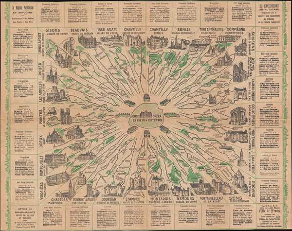
La Région Parisienne en Autocars: 30 Excursion en Autocars Organisées par la Société des Transports en Commun de la Région Parisienne.
sold
- Digital Map Information
- Suitable for large format printing
- File Size: 5.55 MB
- File Type: ZIP / TIFF
- ICC color profile embedded
- Delivered instantly via download link
This is a c. 1924 Société des transports en commun de la région parisienne (STCRP) map illustrating day open-top bus outings operated by the company from Paris. The map depicts thirty different itineraries, all of which leave from the STCRP ... (more details)
An attractive city map of Los Angeles, California.
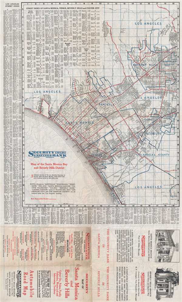
Map of Santa Monica Bay and Beverly Hills District.
sold
- Digital Map Information
- Suitable for large format printing
- File Size: 12.08 MB
- File Type: ZIP / TIFF
- ICC color profile embedded
- Delivered instantly via download link
This is a 1924 Clason Map Company map of Santa Monica and Beverly Hills, California. The map depicts the region from Santa Monica Bay to Beverly Hills and Los Angeles County and from Los Angeles to Playa del Rey. Palms, Culver City, Sawtelle, ... (more details)
Compares the relative size of the world's lakes and islands.

Comparative Size of Lakes and Islands.
sold
- Digital Map Information
- Suitable for large format printing
- File Size: 6.7 MB
- File Type: ZIP / TIFF
- ICC color profile embedded
- Delivered instantly via download link
This is an 1857 J. H. Colton curious topical chart of the world's great islands and lakes. The chart is divided into lakes and islands of the Eastern and Western Hemispheres. Curiously, the chart does not include Greenland - whose northern ... (more details)
The earliest known urban map of Oaxaca.
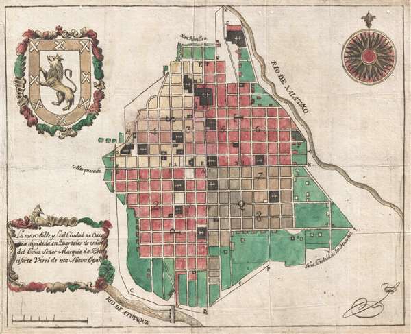
La mas Noble y Leal Ciudad de Oaxaca dividida en Quarteles de orden del exmo. Señor Marques de Branciforte Virei de esta Nueva España.
sold
- Digital Map Information
- Suitable for large format printing
- Full resolution TIFF file
- ICC color profile embedded
- Delivered instantly via download link
This is the earliest known specific printed city plan of Oaxaca de Juarez, Oaxaca, Mexico. The map was printed in Mexico City by the widow of envraver Manuel Galicia de Villavicencio around 1795 under the auspices of the Don Miguel de la ... (more details)
Extremely rare and highly decorative 17th century map of the British Isles.
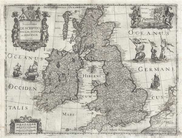
Novissima descriptio Angliae Scotiae et Hiberniae.
sold
- Digital Map Information
- Suitable for large format printing
- DPI: 300
- File Size: 12.04 MB
- File Type: ZIP / TIFF
- ICC color profile embedded
- Delivered instantly via download link
This is an extremely rare and unusual 1639 map of the British Isles by Michel van Lochom. Centered on the Irish Sea, the map extends to cover all of the British Isles, including England, Scotland, Wales, and Ireland. There is an inset ... (more details)
A forgotten milestone in the 18th century mapping of Tibet!
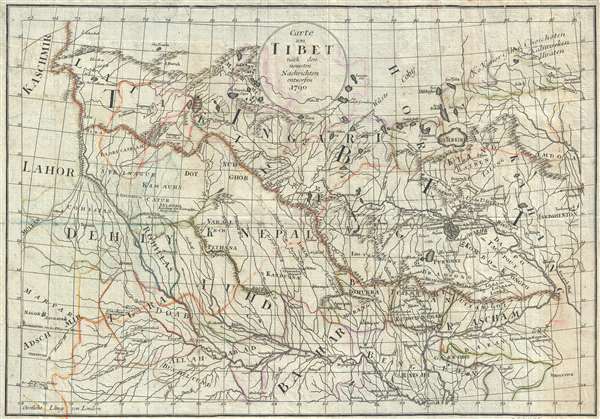
Carte von Tibet nach den neuesten Nachrichten entworfen.
sold
- Digital Map Information
- Suitable for large format printing
- DPI: 300
- File Size: 5.68 MB
- File Type: ZIP / TIFF
- ICC color profile embedded
- Delivered instantly via download link
This is a remarkable and rare 1790 map of Tibet, a milestone in the mapping of that region, and one of the first maps of Tibet, Nepal, and Bhutan with any pretense at accuracy. The map was prepared by Paul Gotthelf Kummer to illustrate ... (more details)
The only commercial atlas map to specifically illustrate Nebraska territory at its ephemeral fullest.
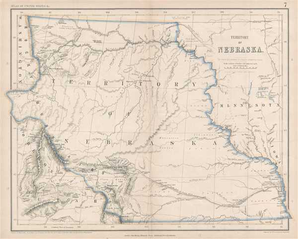
Territory of Nebraska.
sold
- Digital Map Information
- Suitable for large format printing
- File Size: 4.79 MB
- File Type: ZIP / TIFF
- ICC color profile embedded
- Delivered instantly via download link
This is a rare 1857 Henry Darwin Rogers map of the ephemeral Nebraska Territory at its fullest, extending from Kansas to the Canadian border. Few maps illustrate Nebraska in this form, and most of those only as part of a larger map. ... (more details)
Rare set of Spanish nautical charts.
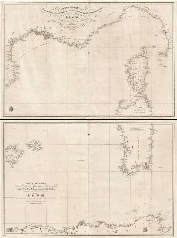
Carta esférica de las costas de Francia, Cerdeña, Luca y Toscana con las yslas de Elba, Córcega y parte septentrional de la de Cerdeña. / Carta Esférica de la Costa de Africa entre Argel y Tunez con parte de las Yslas Baleares y la meridional de Cerdeña.
sold
- Digital Map Information
- Suitable for large format printing
- DPI: 300
- File Size: 33.51 MB
- File Type: ZIP / TIFF
- ICC color profile embedded
- Delivered instantly via download link
This is a rare 1838 two-part Spanish nautical chart of the western Mediterranean in the vicinity of Corsica, Sardinia, and the Balearic Islands. The map covers from Majorca (Mallorca) and Menorca (Minorca) east to Sardinia and ... (more details)
Extraordinary panoramic view of London.
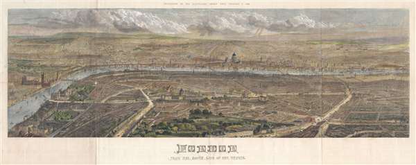
London from the south side of the Thames.
sold
- Digital Map Information
- Suitable for large format printing
- File Size: 43.63 MB
- File Type: ZIP / TIFF
- ICC color profile embedded
- Delivered instantly via download link
An impressive panoramic bird's-eye view of London, England as seen from the south side of the Thames River. The view centers on St. Paul's cathedral with the Thames just below it stretching across the entire canvas. It ... (more details)
Scarce map of the Malay Peninsula and the FMS.
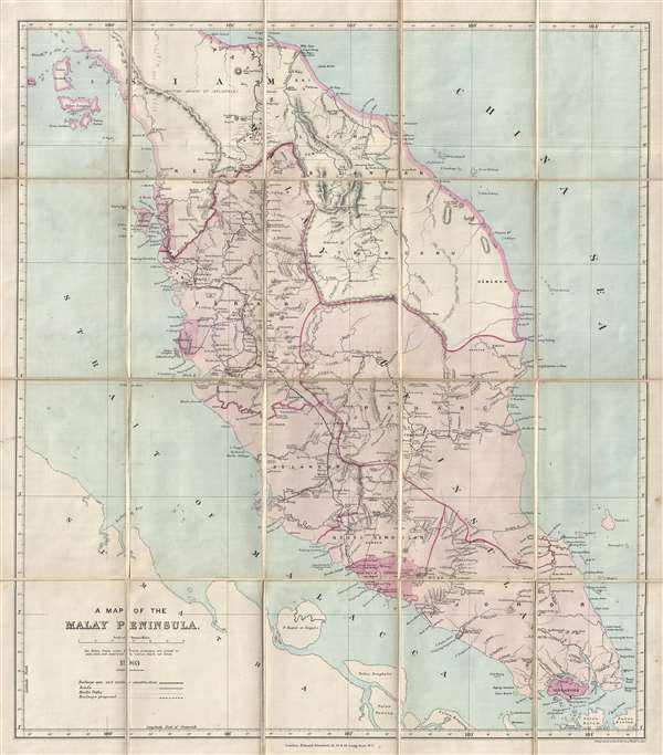
A Map of the Malay Peninsula.
sold
- Digital Map Information
- Suitable for large format printing
- File Size: 8.28 MB
- File Type: ZIP / TIFF
- ICC color profile embedded
- Delivered instantly via download link
This is a 1903 scarce map of the Malay Peninsula by Edward Stanford, including all of modern day Malaysia, Singapore, and parts of Thailand. The map extends form Ko Tarutao and Langkawi, south as far as Singapore and ... (more details)
Beautifully colored view of Harvard College.

Harvard College, 1828.
sold
- Digital Map Information
- Suitable for large format printing
- DPI: 300
- File Size: 3.32 MB
- File Type: ZIP / TIFF
- ICC color profile embedded
- Delivered instantly via download link
This is an 1828 view of Harvard College, Cambridge, Massachusetts. The view depicts, from left to right, Holden Chapel, Stoughton Hall, Hollis Hall, Harvard Hall, University Hall, and Massachusetts Hall. A short ... (more details)
Incredibly attractive map of New England tracing the Boston and Maine Railroad rail network.

Summer Resorts of the Coast, Lake and Mountain Regions along the Boston and Maine Railroad and Connections.
sold
- Digital Map Information
- Suitable for large format printing
- File Size: 31.08 MB
- File Type: ZIP / TIFF
- ICC color profile embedded
- Delivered instantly via download link
This is a wonderfully decorative 1911 Matthews-Northrup map of New England. The map depicts the region from New York City northwards along the Atlantic coast as far as New Brunswick and the Gulf of Saint ... (more details)
Uncommon map illustrating all of Manhattan in 1864.

New-York City County, and Vicinity.
sold
- Digital Map Information
- Suitable for large format printing
- File Size: 14.75 MB
- File Type: ZIP / TIFF
- ICC color profile embedded
- Delivered instantly via download link
This is an uncommon large format 1864 map of New York City by Matthew Dripps. The map covers the entire island of Manhattan as well as parts of Brooklyn, Queens, Hoboken and Jersey City. The whole is ... (more details)