
A Union charge during the Second Battle of Bull Run.
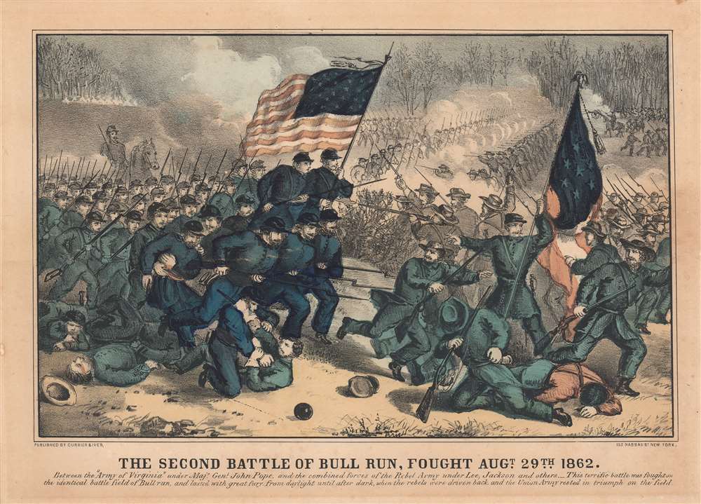
The Second Battle of Bull Run, Fought Augt. 29th 1862.
sold
- Digital Map Information
- Suitable for large format printing
- File Size: 19.51 MB
- File Type: ZIP / TIFF
- ICC color profile embedded
- Delivered instantly via download link
This is an 1862 Currier and Ives view of the Second Battle of Bull Run, fought during the American Civil War. Union Major General John Pope's Army of Virginia appears on the left and General Robert E. Lee's Confederate Army of Northern Virginia occupies the right. Orderly battle lines appear in the background, with Confederates in ranks firing at the advancing Union troops. However, in the foreground, the order dissolves into chaos, with hand-to-hand combat and dead or wounded on the ground. Some Confederate soldiers are retreating. (more details)
One of the earliest maps to illustrate Wyoming as a territory.
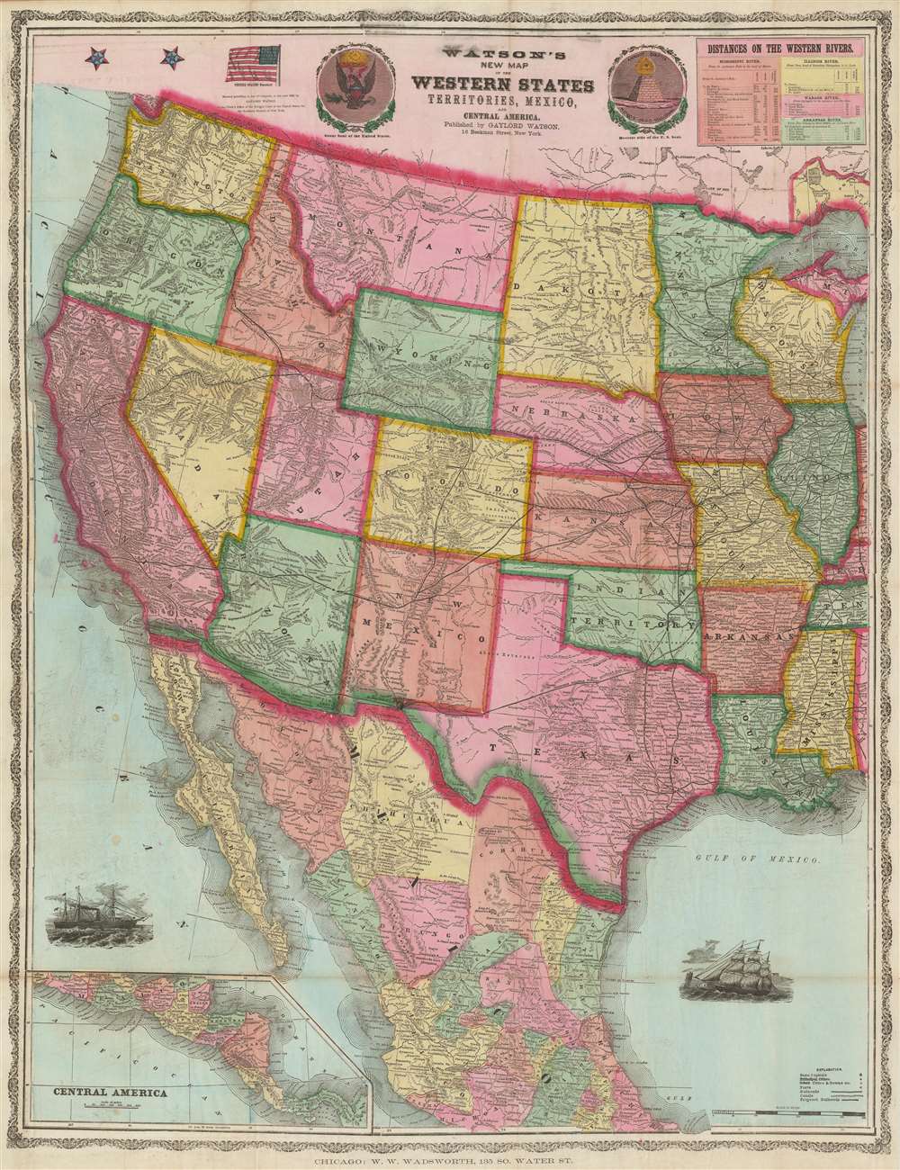
Watson's New Map of the Western States Territories, Mexico and Central America.
sold
- Digital Map Information
- Suitable for large format printing
- File Size: 80.22 MB
- File Type: ZIP / TIFF
- ICC color profile embedded
- Delivered instantly via download link
A visually striking large format 1869 map of the western United States by the New York map publisher Gaylord Watson. The map covers form Illinois and Mississippi to the Pacific. It offers a detailed breakdown of the transcontinental railroad system shortly after the driving of the Golden Spike on May 10, 1869, at Promontory Summit, Utah Territory. This is also one of the earliest maps to illustrate Wyoming after its official designation as a territory in 1868. To the left and right of the title are front and back illustrations of the Great Seal of the United States. In the upper right is a chart illustrating navigable mileage on western rivers, including the Mississippi, Illinois, Wabash, and Arkansas. (more details)
The dominant 16th Century mapping of Paris.

Lutetia vulgari Nomine Paris, Urbs Galliae Maxima, Sequana Navigabili Flumine Irrigatur...
sold
- Digital Map Information
- Suitable for large format printing
- Full resolution TIFF file
- ICC color profile embedded
- Delivered instantly via download link
A handsome example of the Braun and Hogenberg's 1572 map and view of Paris, France. With the Seine flowing at center around the Île de la Cité, this view looks on Paris from the northwest, with the top of the map oriented to the southeast. The city is presented on from equidistant bird's-eye perspective wherein all structures are rendered in view form but from a uniform height and angle relative to all individual points. Fertile fields surround the city, and the rivers bustles with boats, suggesting richness and prosperity. In the bottom left corner, a man greets two women, all wearing clothing corresponding to the Spanish influenced fashion norms of 1560 - 1570. The Bastille, an infamous prison prior to the French Revolution, appears here at top center, surrounded by a moat. The 1550 bastion, appearing to the left of the main structure of the Bastille is also evident. The map's title 'Lutetia' refers to the roman name for Paris which, by the 16th century, had largely been phased out but still appeared in academic references. (more details)
First Double-Hemisphere World in a Printed Atlas.

Orbis Descriptio.
sold
- Digital Map Information
- Suitable for large format printing
- Full resolution TIFF file
- ICC color profile embedded
- Delivered instantly via download link
This is a 1561 first plate issue of Girolamo Ruscelli's double hemisphere map of the world. It is the earliest acquirable world map in this format, and is the first such to appear in a printed atlas. Like most maps in Ruscelli’s Ptolemy, the geographic details were based on Giacomo Gastaldi's (1500 - 1566) 1548 Ptolemy. Here, the double-hemispherical projection transforms this map into fully new composition. Amongst printed maps, it is predated only by the unacquirable 1555 Georgio Sideri 'Calapoda' (fl. 1537–1565) map. (more details)
The first state of the earliest specific map of Brazil.

[Brasil].
sold
- Digital Map Information
- Suitable for large format printing
- Full resolution TIFF file
- ICC color profile embedded
- Delivered instantly via download link
This is the seminal, rare 1556 Giovanni Battista Ramusio map of Brazil, the first printed map to focus specifically on the area. It appeared in Ramusio's 1556 Navigationi et Viaggi, the first collection of explorers' first-hand accounts of their travels. The woodcut represents the first glimpse in print specifically of Brazil. The geographical information is generally credited to Giocomo Gastaldi (1500 - 1566). Much of that detail, and all of the socio-ethno-economic imagery of the map appears to have been drawn either from the 1519 manuscript Lopo Homem (1497 - 1572) Carta do Brasil, or from one or another manuscript of the Dieppe school. This is significant. An overwhelming percentage of maps of South America in the 16th century, printed and manuscript, carry either imagery or text describing the indigenous population as savages and cannibals. Of the early printed maps of Brazil, this is the only to highlight instead the harvesting of the lumber, which represented the initial economic draw for Europeans: Brazil wood, which when harvested and processed produced a highly desirable dye. Not only are the natives shown harvesting trees, and hauling them to the shore - they are also shown with parrots and monkeys, also desirable trade items. More significantly, the map shows a native exchanging lumber for a cup, given by men in European garb. This is one of the only printed maps to depict the active trade which had been underway for decades between French mariners from Normandy and the Tupi peoples of Brazil. Ramusio, as Venetian ambassador to France, may well have had access to French manuscript maps of the Dieppe school (which Surekha Davies notes were remarkable for their depiction of Brazilian indigenes as trade partners rather than predators.) The ships shown sailing the Atlantic here tell a related story: The Portuguese enjoyed a Papally decreed monopoly on the exploitation and colonization of Brazil under the 1494 Treaty of Tordesillas. French / Norman trade with Brazilian natives was done in defiance of the Portuguese, frequently meeting armed resistance. Of the five ships on this map, the smaller three sport the arms of Portugal. The two larger ships in the foreground bear the French fleurs-de-lis. This is a common thread appearing on Ramusio's maps: the notion that whatever the Portuguese have found around the world, the French ought to be able to take. (more details)
A rare map of Hanoi published near the end of the French Indochina War.

Plan de la Ville de Hanoi.
sold
- Digital Map Information
- Suitable for large format printing
- File Size: 15.87 MB
- File Type: ZIP / TIFF
- ICC color profile embedded
- Delivered instantly via download link
This is a 1952 Force terrestres d'Extême-Orient city plan or map of Hanoi, Vietnam. Published near the end of the First Indochina War (1946 - 1954), the map details a city that had been at war since 1940. Streets bear French names and are labeled in French, although a handful bear Vietnamese names and are labeled as such. Intriguingly, the lakes all have Vietnamese names. The train station is marked by diagonal hatching, along with the library, military hospital, the Institut Pasteur, and several other unlabeled buildings. The citadel, in the northern part of the city and the heart of the French colonial administration, appears in the upper part of the map and is highlighted in yellow manuscript. Lines consisting of dots and dashes traces the city's electrical tramway system. (more details)
The FEC reaches Key West!

Map of the Peninsula of Florida and Adjacent Islands.
sold
- Digital Map Information
- Suitable for large format printing
- File Size: 47.19 MB
- File Type: ZIP / TIFF
- ICC color profile embedded
- Delivered instantly via download link
A highly decorative 1914 map of Peninsular Florida issued by the Mathews-Northrup Company for the Henry Morrison Flagler’s (1830 – 1913) Florida East Coast Railway. The map covers from the Georgia Border to Key West and Cuba, and from Cedar Key to the Bahamas. The route of the railroad is illustrated in red overprinting extending from Jacksonville to Key West, with major stops, and the grand hotels available there, including the Royal Palm, the Breakers, the Ponce de Leon, and the Ormond, noted. The map also identifies drainage canals from Lake Okeechobee constructed by J. O. Wright to grade the Everglades. (more details)
Florence - meet the automobile!
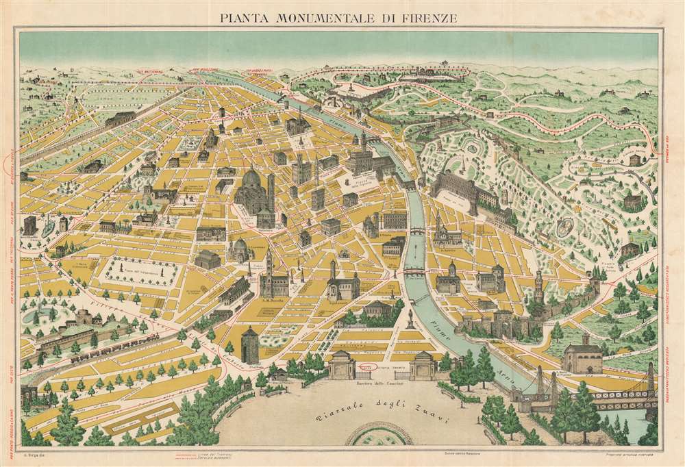
Pianta Monumentale di Firenze.
sold
- Digital Map Information
- Suitable for large format printing
- Full resolution TIFF file
- ICC color profile embedded
- Delivered instantly via download link
A rare pictorial chromolithograph perspective view and map of Florence / Firenze, Italy. The view is centered roughly on the Palazzo Vecchio, and looks south on Florence from a fictional highpoint above today's Pizzale Vittorio Veneto, labeled here Piazzale degli Zuavi. The map follows in a style popular at time wherein buildings and monuments are superimposed as profile vignettes over an otherwise simple perspective map - impractical for serious navigation, but a wonderful aid to the tourist on foot. Here, red highlighting illustrates tram routes (solid lines) and automobile routes (dashed lines, note there are only 3 such roads). Similar maps have been made of Paris, London, Rome, Madrid, and other popular European tourist centers. (more details)
Text in both English and Lao.

ແຜນທີ່ປ:ກອບພາປ ວຽງຈັນ. / Map of Vientiane Province.
sold
This is a c. 1960 pictorial map of Vientiane, Laos. Printed in English and Lao (with French and Lao street names), over 108 locations across the city are illustrated in profile and numerically identified. These correspond with a bilingual guide situated in the bottom left naming temples, markets, schools, and government buildings. A dragon marks the Air Vietnam office, while a winged horse identifies the office of Air Laos. Several embassies are identified, among them the American Embassy, the Thai Embassy, and the Indian and Vietnamese Legations. The offices of the International Control Commission (ICC) are illustrated, with a maple leaf marking the Canadian office. The ICC was created to monitor and observe the ceasefires in Cambodia, Laos, and Vietnam following the 1954 Geneva Accords. It existed until 1973 when it was replaced by the International Commission for Control and Supervision. (more details)
The trans-Pacfic aviation race.

太平洋横断飛行競争盤 / Trans-Pacific Flight Game Board. / 城攻め一番乗り双六 / Castle Attack Sugoroku.
sold
- Digital Map Information
- Suitable for large format printing
- Full resolution TIFF file
- ICC color profile embedded
- Delivered instantly via download link
This is a rare 1927 (Showa 2) map and Sugoroku board drawn to promote Japanese ambitions to achieve the first solo trans-Pacific flight. The map was published by Dainippon Yutsukai Kodansha (大日本雄辯會講談社) as a New Year supplement to their 'Japanese Youth Club' periodical. The map is printed on both sides. The more interesting side (to us), is the trans-pacific flight Sugoroku. The opposite side features a brightly lithographed castle siege game. (more details)
The end of Napoleon's reign.
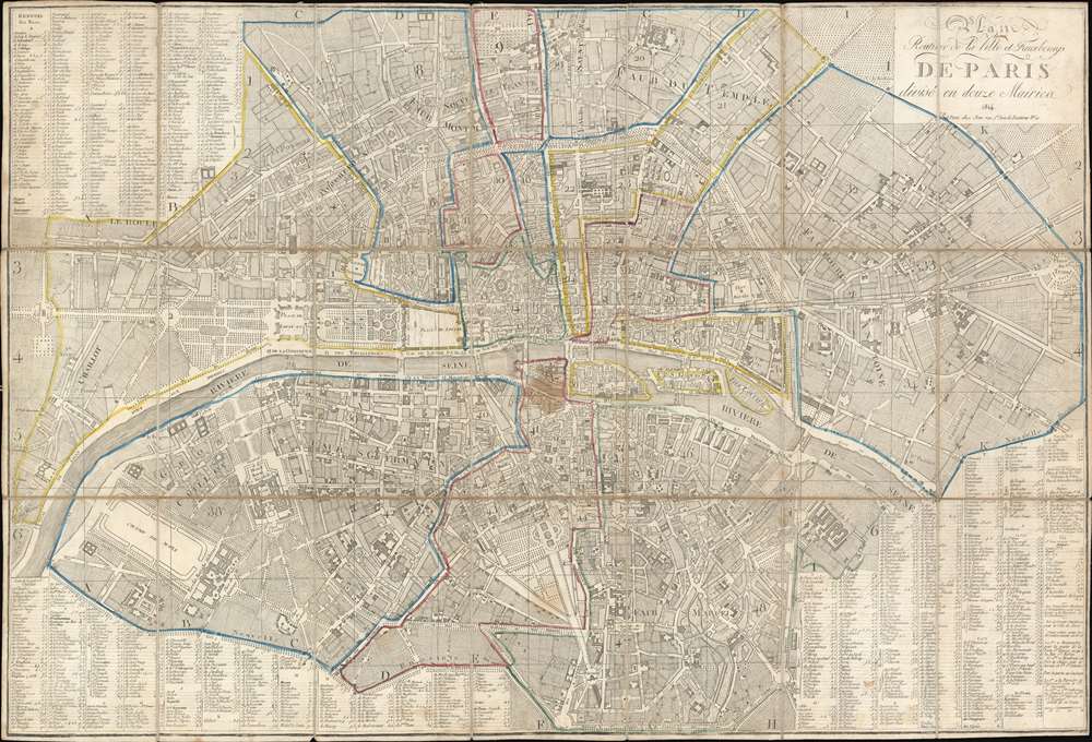
Plan Routier de la Ville et Faubourgs de Paris divisé en douze Mairies.
sold
- Digital Map Information
- Suitable for large format printing
- Full resolution TIFF file
- ICC color profile embedded
- Delivered instantly via download link
This is an 1814 Chez Jean city plan or map of Paris, France. The map captures Paris on the cusp of transformation, just prior Emperor Napoleon Bonaparte's defeat (1814/15) and the Bourbon Restoration. The map significantly predates the major reforms and retrogressions of the Bourbon Restoration (1814 - 1830). Celebrated Parisian landmarks, including Napoleon's Arc de Triomphe at the Place de l'Étoile, the Louvre, the Jardin des Tuileries, and Notre Dame, all appear. Street indexes occupy three of the four corners, with the title occupying the fourth. (more details)
India's railroad network.
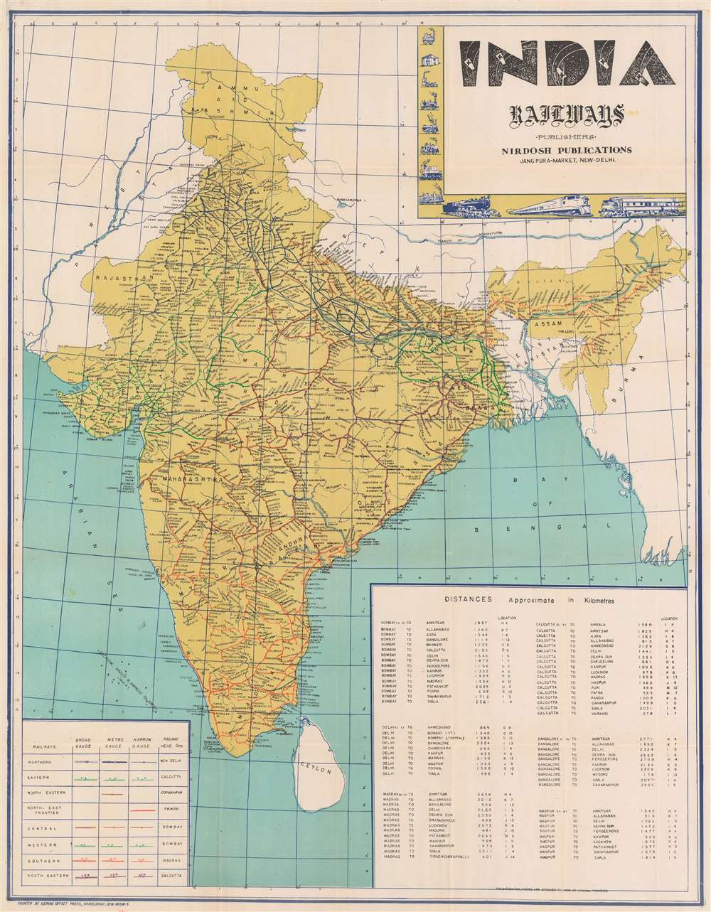
India Railways.
$500.00
Acquire
This is a c. 1960 railroad map of India. Depicting India's railroad network in detail, its eight different railways are differentiated by color and then further divided by track gauge. The routes of the Eastern Railway, Western Railway, Southern Railway, and Southeastern Railway are labeled as well. Cities and towns are labeled along every line and a table providing distances between major cities in kilometers occupies the lower right. A key situated in the lower left explains notations used to differentiate railways and broad-, meter-, and narrow-gauge lines. A decorative title cartouche appears in the upper right bordered by vignettes of historical train engines. (more details)
First scientific survey of Central Madagascar.
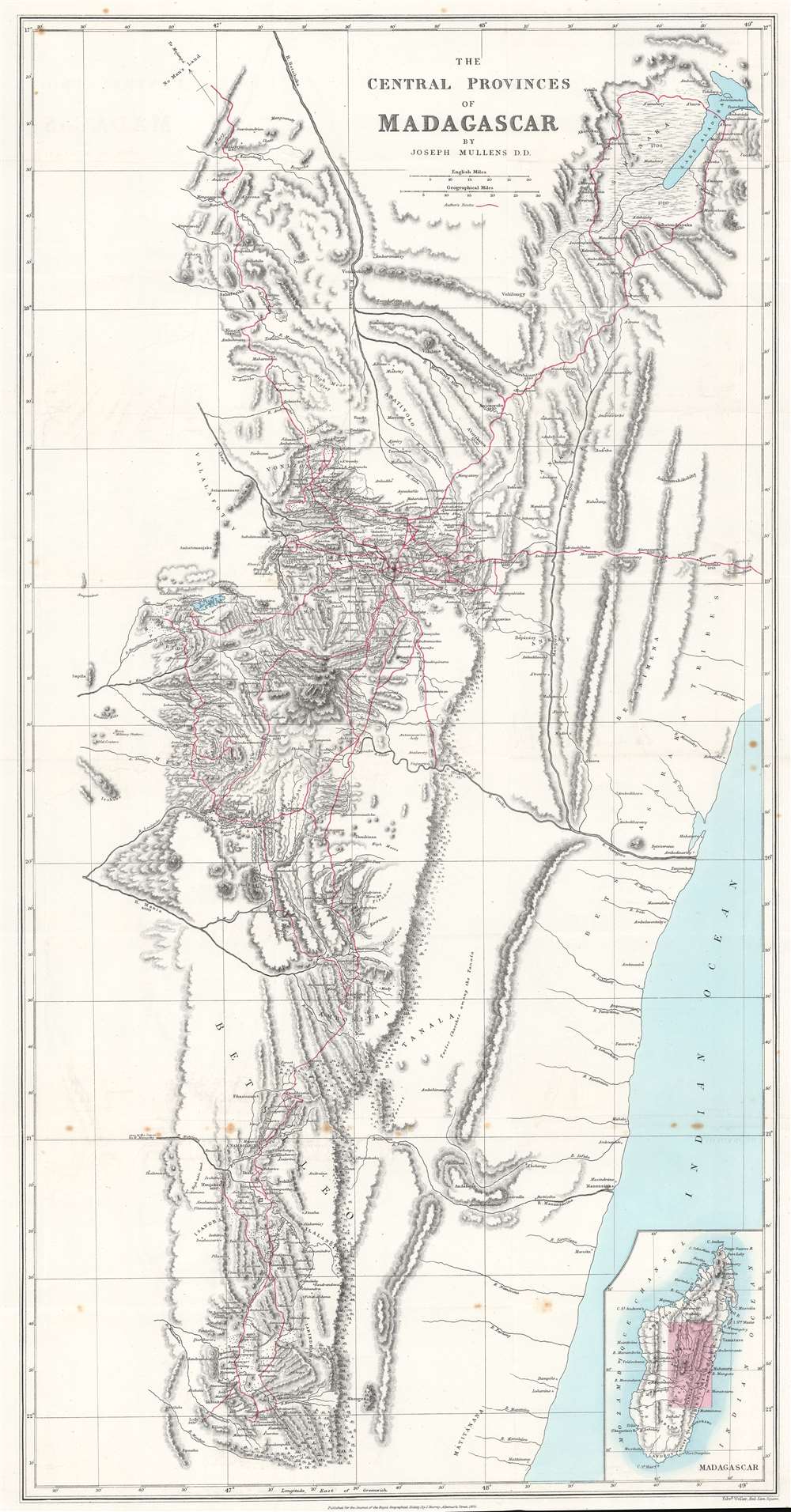
The Central Provinces of Madagascar.
sold
- Digital Map Information
- Suitable for large format printing
- File Size: 21.02 MB
- File Type: ZIP / TIFF
- ICC color profile embedded
- Delivered instantly via download link
This is an 1875 John Mullens map of the central provinces of Madagascar - considered the first scientific survey of the central provinces around Antananarivo, the island's capital. Red lines trace Mullens's peregrinations as an official of the London Missionary Society. He was widely welcomed as a guest and given free rein to collect geographical and cartographic data. Throughout, cites, towns, and villages are identified for the first time on a modern map. Mountains are named and elevations given. An inset in the lower right illustrates this map in the context the entirety of Madagascar. (more details)
German interest in the Transvaal?

Original Map of the Transvaal or South-African Republic.
sold
- Digital Map Information
- Suitable for large format printing
- File Size: 26.44 MB
- File Type: ZIP / TIFF
- ICC color profile embedded
- Delivered instantly via download link
This is an 1868 Frederick Jeppe and Augustus Petermann map of the Transvaal, South Africa. Composed in English but published by a German publishing house (likely to capitalize on a British audience), the map details the emerging Transvaal Republic and surrounding region. The Transvaal Republic is outlined in orange and the 'limit of the tsetse fly' is emphasized by light green. The treks of eight explorers active 1844 until 1867 are traced and highlighted. Cities, towns, and villages are labeled, including Pretoria and Potchefstroom. A large inset in the upper left situates the Transvaal Republic within the greater region and labels numerous surrounding polities, including the Oranje River Freestate. Smaller inset maps detail Rustenburg, Pretoria, and Potchefstroom. (more details)
One of the most attractive American atlas maps of Washington D.C. to appear in the mid-19th century.
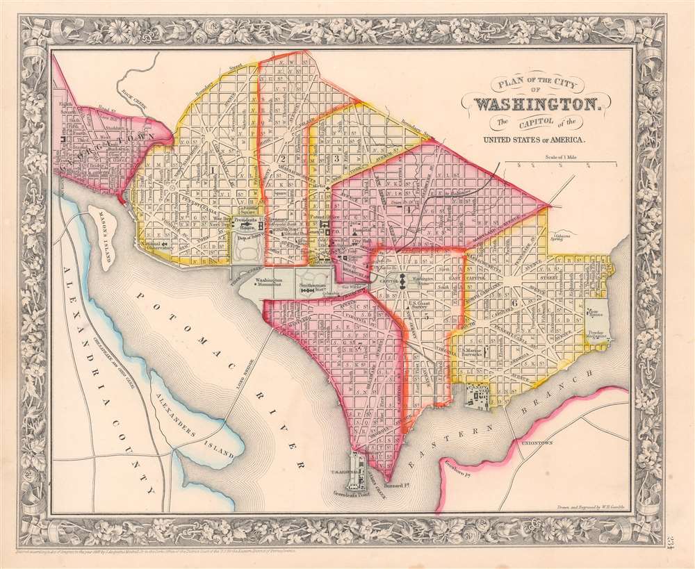
Plan of the City of Washington. The Capitol of the United States of America.
sold
- Digital Map Information
- Suitable for large format printing
- File Size: 10.5 MB
- File Type: ZIP / TIFF
- ICC color profile embedded
- Delivered instantly via download link
This is an 1860 Samuel Augustus Mitchell, Jr. city plan or map of Washington, D.C. The map depicts the city from Georgetown to the Anacostia River (Eastern Branch) and from Boundary Street to Greenleafs Point and the confluence of the Anacostia and Potomac Rivers. Highly detailed, numerous buildings throughout the city are labeled, including the U.S. Capitol Building, the Smithsonian Institution, the Washington Monument, and the White House. The Navy Department, War Department, and U.S. Treasury are also identified, as are the Patent Office, the General Post Office, the U.S. Navy Yard, and the U.S. Arsenal. Nearly every street in the city is labeled, and Washington D.C.'s iconic street layout is easily recognizable. The Chesapeake and Ohio Canal, which eased river travel along the Potomac, is across the river in Alexandria, Virginia. (more details)
The Earliest Printed Chart of South Africa.

Carta particolare che comincia con il capo Degortam e con il capo Buona Speranza e finisce in gradi 27 di latitudine Australe.
sold
- Digital Map Information
- Suitable for large format printing
- Full resolution TIFF file
- ICC color profile embedded
- Delivered instantly via download link
This is a superb example of Robert Dudley's 1647 coastal chart of South Africa. It was included in Dudley's Arcano del Mare, hailed by Tooley as
The inclusion of coastal recognition views of the Cape of Good Hope, Cape Hangklip and Cape Agulhas on this particular chart suggests that Dudley, or his source for this chart, had benefited from actually having seen these shores. All of these views were landmarks of note for mariners rounding the Cape. (more details)
the first sea atlas in which every chart was based on Mercator’s projection, the first to show prevailing winds and currents in the main harbours and anchorages, the first to give magnetic declination, and the first sea atlas by an Englishman.At least in principle, these navigational notes and the adherence to the Mercator projection would make Dudley's charts the first to be of any use at sea. The present chart exhibits all of these qualities.
The inclusion of coastal recognition views of the Cape of Good Hope, Cape Hangklip and Cape Agulhas on this particular chart suggests that Dudley, or his source for this chart, had benefited from actually having seen these shores. All of these views were landmarks of note for mariners rounding the Cape. (more details)
Quack science wins again!

Know Thyself! Lectures on Phrenology by Dr. J. P. M'Lean.
sold
- Digital Map Information
- Suitable for large format printing
- File Size: 121.4 MB
- File Type: ZIP / TIFF
- ICC color profile embedded
- Delivered instantly via download link
This is an uncommon c. 1865 promotional broadside advertising a lecture by the itinerant mesmerist and phrenologist J. P. M'Lean (MacLean). The broadside focuses on the 'Symbolical Head' offering the classic phrenological brain map, divided into modules representing faculties, which contain images of the postulated functions. Below the 'Symbolical Head' a framed area with red type advertises lectures by Dr. J. P. M'Lean, an associate of the Aberdeen Phrenological Society. Surrounding the advertisement are 56 illustrations of differently shaped heads, many of which are drawn from previous illustrations present in phrenological books published by Fowler and Wells. Lectures were on such subjects as 'How to Read Character Scientifically' and would be followed by 'Public Examinations,' presumably conducted by M'Lean. (more details)
Iconic Tolkien promotional poster map.

A Map of Middle-Earth.
sold
This is the iconic 1970 rare poster map of J. R. R. Tolkien's Middle Earth drawn by Pauline Diana Baynes to promote the George, Allen and Unwin release of the Lord of the Rings. Tolkien heaped praise upon Baynes' work, saying 'They are more than illustrations, they are a collateral theme. I showed them to my friends whose polite comment was that they reduced my text to a commentary on the drawings.' (more details)
Travel by rail and go on vacation!
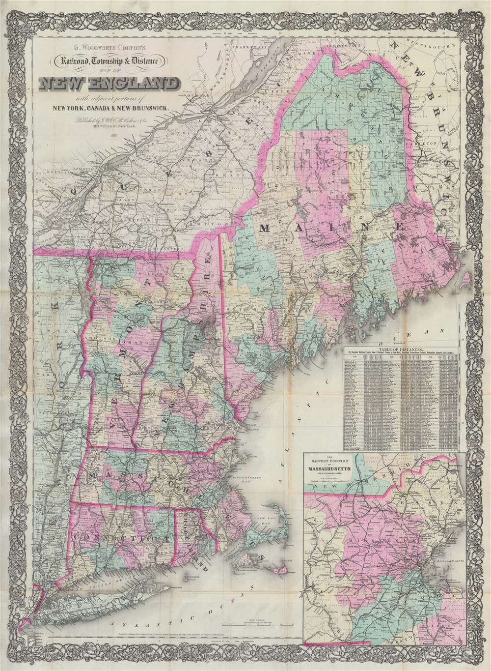
G. Woolworth Colton's Railroad, Township and Distance Map of New England with adjacent portions of New York, Canada and New Brunswick.
sold
- Digital Map Information
- Suitable for large format printing
- Full resolution TIFF file
- ICC color profile embedded
- Delivered instantly via download link
This is an 1886 George Woolworth and Charles B. Colton railroad pocket map of New England. Created as a travel aid, the map details the expansive railroad network extending from Maine and Quebec to Long Island. Towns and villages along the railroad lines are identified and mileage is provided. An inset in the lower right focuses on the busy eastern Massachusetts corridor between Boston and Worcester. A table above the inset contains distances by rail from nearly 200 towns to New York, Hartford, Providence, Boston, Montpelier, Concord, and Augusta. (more details)
Holy and Secular.
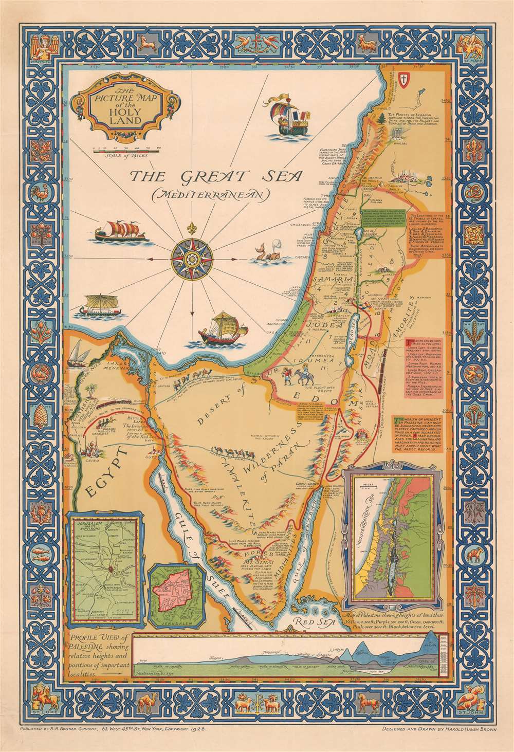
The Picture Map of the Holy Land.
sold
- Digital Map Information
- Suitable for large format printing
- File Size: 34.11 MB
- File Type: ZIP / TIFF
- ICC color profile embedded
- Delivered instantly via download link
This is a 1928 Harold Haven Brown pictorial map of the Holy Land / Israel and/or Palestine, including the Sinai, and parts of Egypt, Syria, Jordan, and Lebanon. The map depicts the region from the Nile River to Ammon (Syria) and from Tripolis (Tripoli), Lebanon to the Red Sea. (more details)