
With outstanding whaling annotations in manuscript.

Chart of the East Coast of Madagascar, including the Mauritius, Seychelle Islands and c.
sold
- Digital Map Information
- Suitable for large format printing
- DPI: 600
- File Size: 20.05 MB
- File Type: ZIP / TIFF
- ICC color profile embedded
- Delivered instantly via download link
An exceptional British Admiralty / William Fitzwilliam Owen 1846 nautical chart of northeast Madagascar, Mauritius, and the Seychelles Archipelago with unique manuscript annotations relating to a series of c. 1852 - 1856 whaling voyages in the south Indian Ocean. The annotations including charmingly illustrated whale tails recording whale sightings and takings, some of which are dated, others of which appear to relate to a numeric key, now lost. (more details)
The Theatre of the First Anglo-Afghan War: The Beginning of The Great Game and the scene of the Disaster in Afghanistan

Map of Afghaunistan, Caubul, the Punjab, Rajpootana, and the River Indus
sold
- Digital Map Information
- Suitable for large format printing
- DPI: 600
- File Size: 37.01 MB
- File Type: ZIP / TIFF
- ICC color profile embedded
- Delivered instantly via download link
This is an 1842 Wyld map of Afghanistan and its surrounds, showing the theatre of the First Anglo-Afghan War: the first major conflict of ‘The Great Game’ for British control of India. It was printed just three months after the disastrous Retreat from Kabul. Though the debacle is not specifically referred to on the map, the passes between Kabul and Peshawar are shown with sufficient detail (surpassing other contemporaneous maps of the area ) that it seems clear that the map reflects the best British understanding of Afghanistan’s geography at the time of the conflict. These include Gandamak - the pass approaching Jalalabad in which the massacre of Elphinstone's army took place between January 6 and January 13, 1842. (more details)
An incredibly detailed map of the North Island of New Zealand.
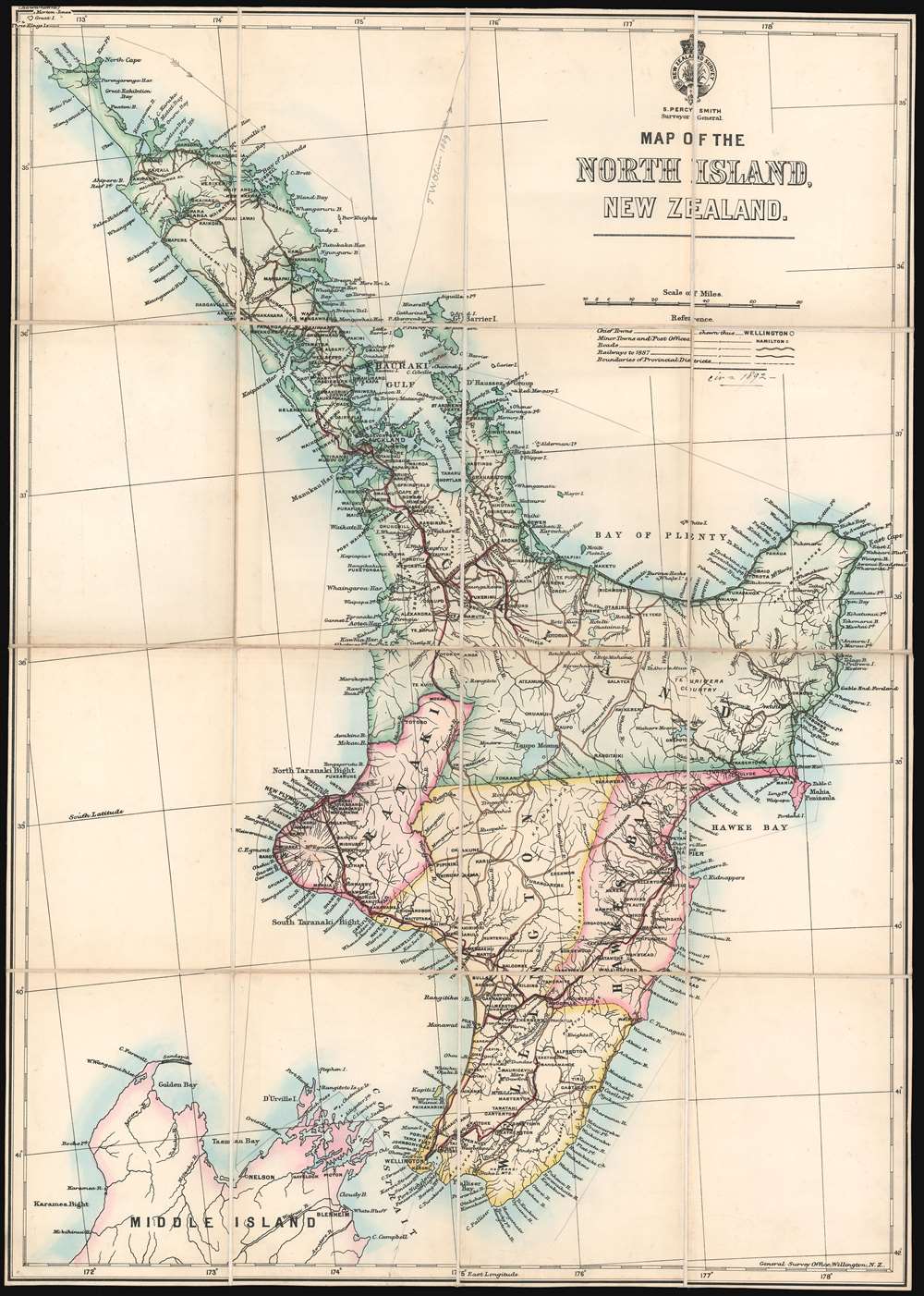
Map of the North Island, New Zealand.
sold
- Digital Map Information
- Suitable for large format printing
- File Size: 28.54 MB
- File Type: ZIP / TIFF
- ICC color profile embedded
- Delivered instantly via download link
This is a c. 1891 New Zealand General Survey Office map of the North Island of New Zealand. The map depicts the region from the Tasman Sea to the South Pacific Ocean and from the Three Kings Islands to Karamea Bight. Highly detailed, myriad cities, towns, and villages are labeled throughout the island, including Auckland and Wellington. Roads are illustrated across the island, along with railroads as of 1887. Numerous coastal islands, points, bays, and other formations are also identified. A ship's course around nearly all of the North Island is indicated in manuscript, with the notation 'T.W. Oliver 1889' marked above Hauraki Gulf. Unfortunately, we have been unable to trace this reference. (more details)
The Summation of the First European Surveys of Northern Arabia Embracing the History of the Arab Revolt
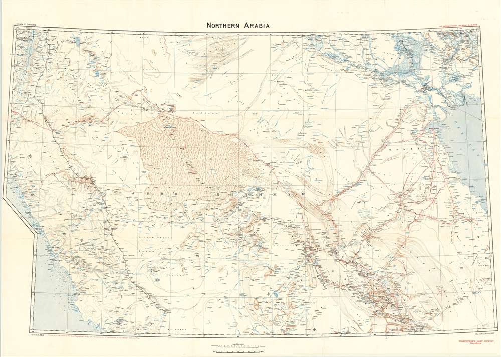
Northern Arabia/ Shakespear's Last Journey. Carruthers. GSGS 2931.
sold
- Digital Map Information
- Suitable for large format printing
- File Size: 46.17 MB
- File Type: ZIP / TIFF
- ICC color profile embedded
- Delivered instantly via download link
This 1922 Royal Geographic Society map of northern Arabia, Jordan, Kuwait and Southern Iraq, capturing the first European surveys of this region, frames the dramatic story of the first efforts on the part of the British government not only to map this previously uncharted part of the world, but also to build alliances in the sweep of the Great War. The map - very probably the work of Douglas Carruthers, but attributed only to the General Staff Geographical Section of the British War Office - has been further overprinted by Carruthers himself to highlight the heroic accomplishments of Captain William Shakespear, the first European to map the north-central part of the Arabian Peninsula and the friend and military advisor to Ibn Saud, the man who would become King of Arabia and founder of the ruling family. (more details)
Promotes steamship routes to the West Indies, Central, and South America leaving from Tampa, Florida.

The Plant System Via Port Tampa to Cuba, West Indies, Mexico, South and Central America.
sold
- Digital Map Information
- Suitable for large format printing
- File Size: 29.16 MB
- File Type: ZIP / TIFF
- ICC color profile embedded
- Delivered instantly via download link
This is an 1889 Matthews, Northrup, and Company map of North America promoting Tampa, Florida as national transport hub for both land and sea routes. Known as the Plant System, the map depicts a vast transportation network centered on Tampa, but extending from Nevada and Idaho to the Windward Islands and from Quebec to northern South America. Thick black lines mark Plant System rail lines along the East Coast from New York to Tampa, with thick dashed lines illustrating Plant Steamship lines from Tampa to Mobile, Alabama and from Tampa to Havana, Cuba via Key West. Thinner black lines highlight affiliated rail lines in the central U.S., while even thinner lines illustrate the rest of the rail network spreading out like a spider's web across the country. Other steamship routes throughout the Caribbean are also included, rendering apparent that travel is possible between all the islands in the West Indies, Mexico, and Central and South America. Advertisements promoting worldwide travel flank the map on both sides, touting the fact that travelers can purchase tickets to any of the locations illustrated on the map plus several different cities in Europe, including London and Paris, from Plant System agents. (more details)
Published August 27, 1939, only days before Hitler's Germany invades Poland and begins World War II.
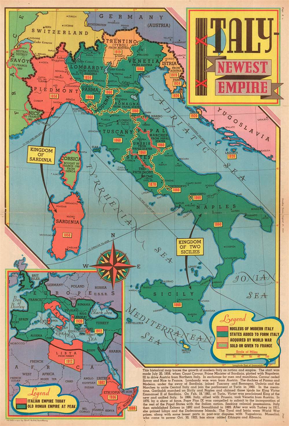
Italy - Newest Empire.
sold
- Digital Map Information
- Suitable for large format printing
- File Size: 26.01 MB
- File Type: ZIP / TIFF
- ICC color profile embedded
- Delivered instantly via download link
This is a 1939 Edwin Sundberg map of Italy published days before the outbreak of World War II. The map depicts the region from France to Yugoslavia and from Germany and Switzerland to Sicily and the Mediterranean Sea. Focusing on the development of Italy from a collection of principalities and duchies into a unified country, small yellow boxes with red font boldly declare when each area was incorporated into the whole. An inset map in the lower left corner highlights Italy's territorial gains outside its home peninsula, placing its colonial adventurism in Africa and its war gains in contrast with the Ancient Roman Empire, which served as Mussolini's inspiration. (more details)
Sears and Roebuck Prepare Their Radio Customers for The Next War (By Preparing Them For The Previous One)

Rand McNally standard map of Europe./ Sears Silvertone radio European War Map.
sold
- Digital Map Information
- Suitable for large format printing
- File Size: 73.03 MB
- File Type: ZIP / TIFF
- ICC color profile embedded
- Delivered instantly via download link
This is a 1940 Rand McNally Map of Europe, published for Sears and Roebuck as a promotion for their Silvertone line of electronics - 'Keep Posted with a Silvertone Radio!' The recto map displays what was, for the American audience, the expected theatre of what would undoubtably be a simple re-play of the first World War: the continent of Europe. The brightly-colored map shows the 1939 national boundaries, with pre-World War borders marked in red for reference. (Thus, the borders of Austria-Hungary and the Balkans can be seen, as can the pre-Soviet Russia.) To provide a sense of scale for the American reader, an outline of the State of Missouri has been added - suggesting that any one of the players in the upcoming conflict was barely the size of just one small part of the United States. (more details)
A Detailed and Attractive Map of Maritime Canada
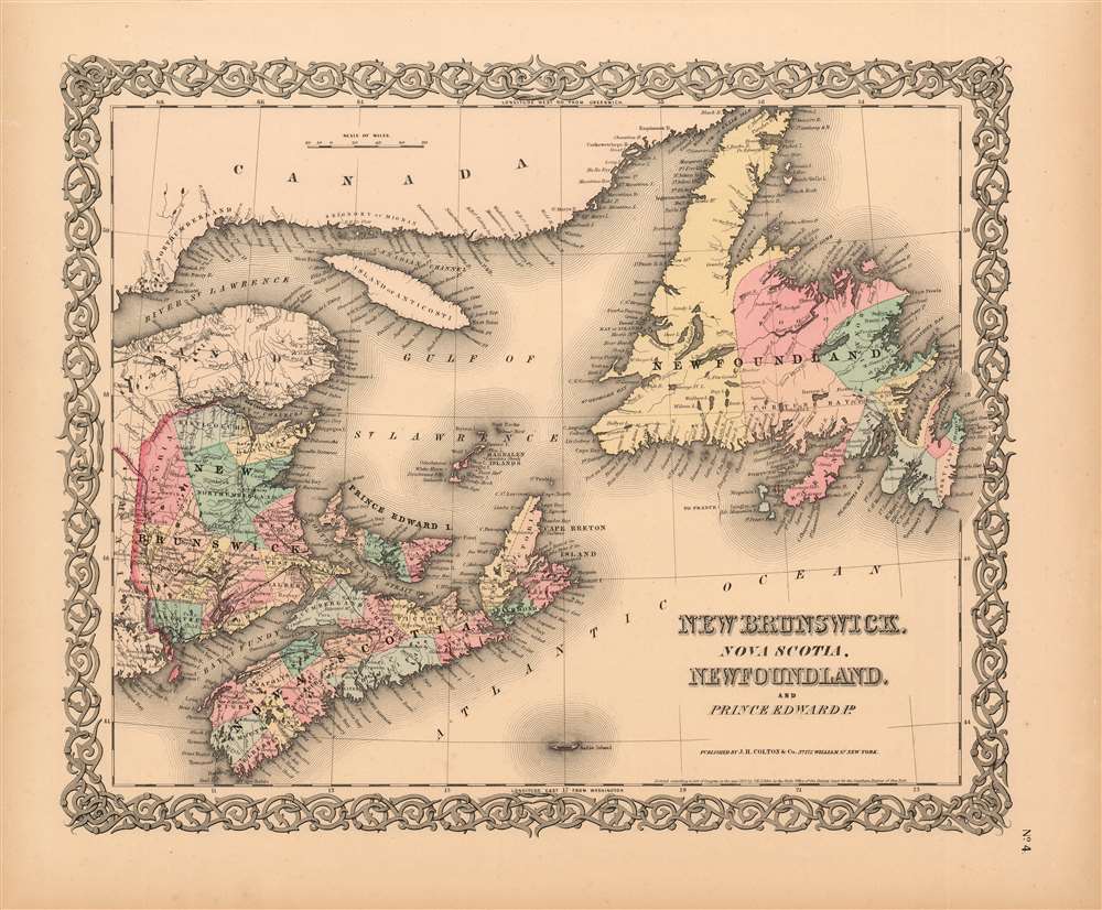
New Brunswick, Nova Scotia, Newfoundland, and Price Edward Id.
$125.00
Acquire
- Digital Map Information
- Suitable for large format printing
- File Size: 17.25 MB
- File Type: ZIP / TIFF
- ICC color profile embedded
- Delivered instantly via download link
This is Colton's scarce 1855 map of the Maritime Provinces of Eastern Canada: New Brunswick, Nova Scotia, Newfoundland and Prince Edward Island. The map shows a portion of what appears to be the European and North American Railway, which would not officially opened until 1857. It would eventually extend to Shediac Bay; here, rails link St. Stephens to Portland in southern New Brunswick. In addition, map Colton identifies various cities, towns, forts, rivers, rapids, fords, with topographical features shown with hachure. The attractive map is colored in pink, green, yellow and blue hand color to distinguish national and regional boundaries, and is embellished with Colton's characteristic spiral motif border. (more details)
A charming pictorial map of St. George, Bermuda - Bermuda's first capital.
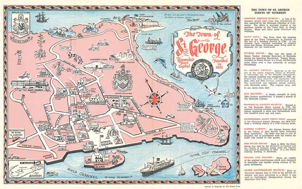
Pictorial Map of the town of Saint George Bermuda.
sold
- Digital Map Information
- Suitable for large format printing
- File Size: 12.52 MB
- File Type: ZIP / TIFF
- ICC color profile embedded
- Delivered instantly via download link
This is a c. 1960 Ken Giles pictorial map of St. George, Bermuda. The map depicts the city from the Saint George Hotel to Gates Fort and from Fort St. Catherine to Higgs Island. Charmingly illustrated, sites around the city are illustrated by profile vignettes. Several forts are illustrated, as are King's Square, the carriage museum, and the gunpowder cavern. (more details)
With outstanding whaling annotations in manuscript.
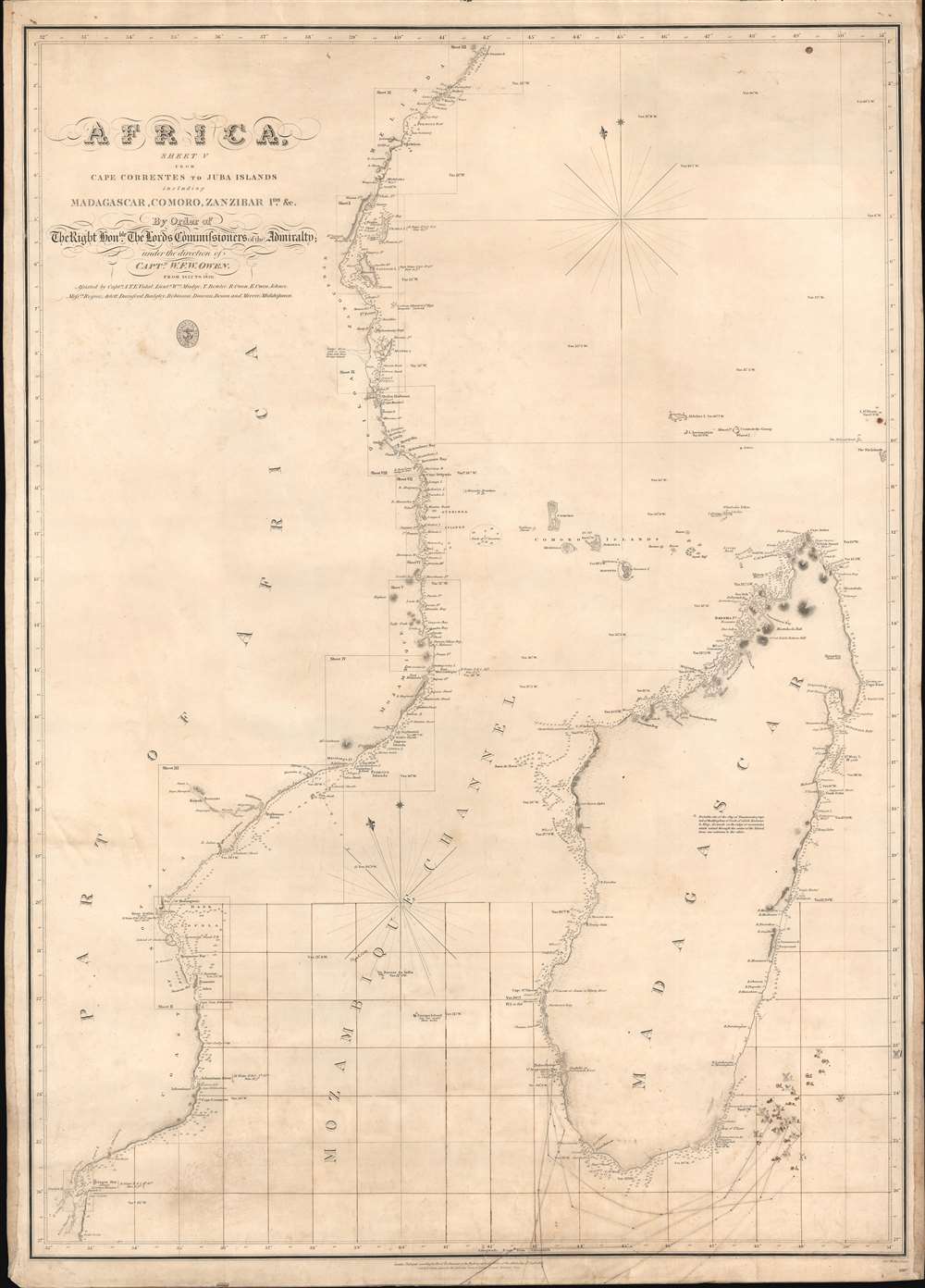
Africa Sheet V from Cape Correntes to Juba Islands including Madagascar, Comoro, Zanzibar Ids. And c.
sold
- Digital Map Information
- Suitable for large format printing
- DPI: 600
- File Size: 27.99 MB
- File Type: ZIP / TIFF
- ICC color profile embedded
- Delivered instantly via download link
An exceptional British Admiralty / William Fitzwilliam Owen 1828 nautical chart of Madagascar, Southeast Africa, and the Mozambique Channel, with unique manuscript annotations relating to a series of c. 1852 - 1856 whaling voyages in the south Indian Ocean. The annotations including charmingly illustrated whale tails recording whale sightings and takings, some of which are dated, others of which appear to relate to a numeric key, now lost. (more details)
Important second edition of Mercator and Hondius' Map of the Arctic showing a break with 16th century cartographic convention.
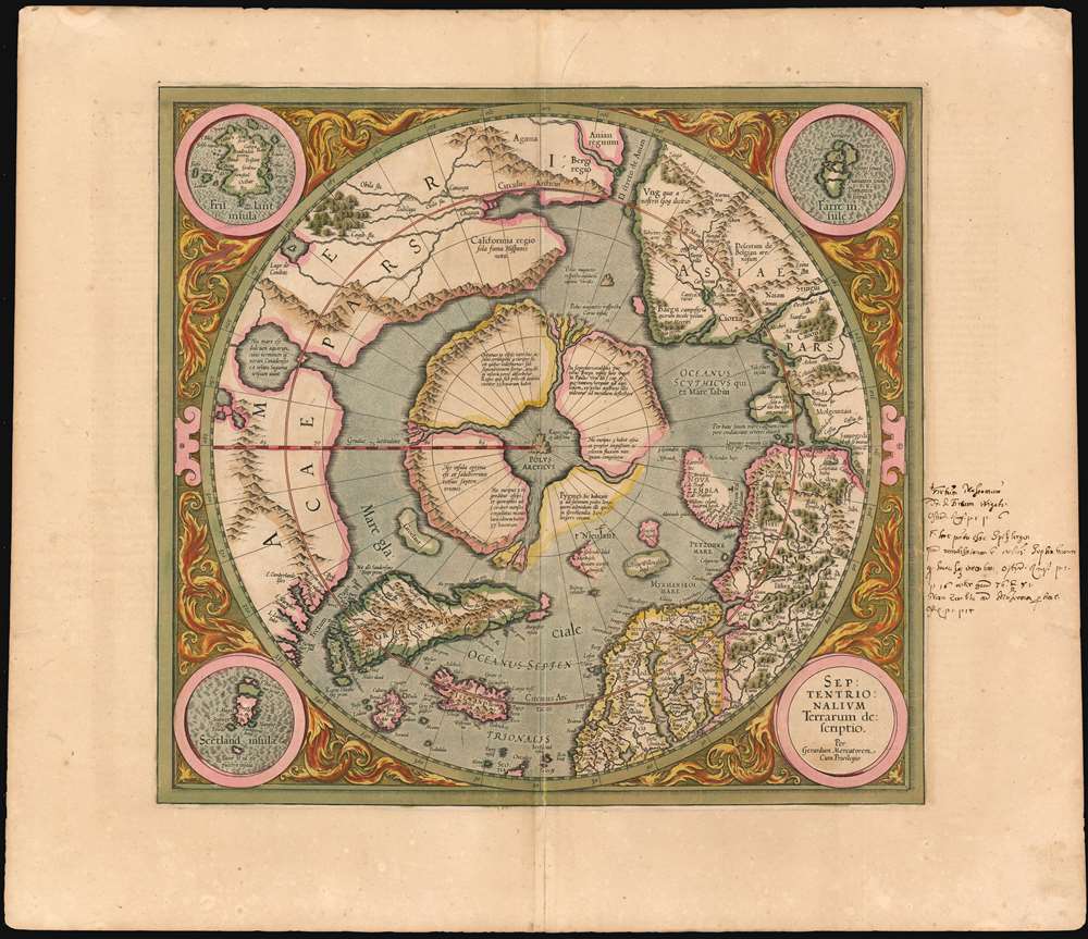
Septentrionalium Terrarum descriptio.
sold
- Digital Map Information
- Suitable for large format printing
- DPI: 600
- File Size: 23.59 MB
- File Type: ZIP / TIFF
- ICC color profile embedded
- Delivered instantly via download link
This is the second state of Gerard Mercator's 1606 map of the North Pole or Arctic, one of the great cartographer's most interesting and important maps. Mercator's Arctic projection has its roots in a magnificent 1569 wall map of the world in which Mercator first introduces his revolutionary projection. As regards the Arctic, the difficulty with the Mercator Projection is that to accurately depict the Polar Regions, a map would have to be infinitely tall. Mercator compensated for this by including a polar projection, very similar to the map shown here, in the lower-left hand corner of his great map. This may rightly be considered to be the world's first specific map of the North Pole. Mercator later reissued this map in an expanded format for his 1595 atlas. Following a number of important expeditions to the Arctic in subsequent 10 years, Mercator's successor Jodocus Hondius reissued the original 1595 map with a number of revolutionary and highly significant changes. (more details)
Strange Arabic- Boston imprint from first wave of Islamic immigration to the United States.

Bird's Eye View of Holy Jerusalem. / Vue Générale de la Villie de Jerusalem. / القدس الشف
sold
- Digital Map Information
- Suitable for large format printing
- File Size: 59.52 MB
- File Type: ZIP / TIFF
- ICC color profile embedded
- Delivered instantly via download link
The only known example of a magnificent and previously unknown c. 1896 Boston-Arab chromolithograph view of Jerusalem by the Palestinian / Syrian immigrant Aece Hage. This view is a veritable masterpiece of chromolithography, employing at least six separate plates, a feat even more remarkable when compounded with the knowledge that this view was produced in a flophouse under extenuating circumstances and on a low budget. The unusual view looks on Jerusalem from the Mount of Olives, east of the Old City, and centers on the Temple Mount and the Dome of the Rock (Qubbat al-Sakhrah), with other holy sites of multiple religions appearing behind it. In the foreground the Eastern Wall of Jerusalem, the walled off Golden Gate, the open Lion's Gate, and the 1400-year-old Bab-ur-Rahmah Cemetery are illustrated. The predominate colors, blue and green, are significant in Islamic tradition, representing protection, hope, and life. The view, although stylized, is mostly accurate, suggesting that Hage (or the artist) had been to or lived in Jerusalem and drew the image from life.
The view is titled in light brown lettering to either side of the view, and in the bottom right just below the view. Title text appears in English (left), French (right) and Arabic (bottom right). Text below the map identifies 15 locations, which correspond to numerical assignments appearing on the map. The cartographer identifies Christian, Muslim, and Jewish religious sites, without apparent preference. (more details)
The view is titled in light brown lettering to either side of the view, and in the bottom right just below the view. Title text appears in English (left), French (right) and Arabic (bottom right). Text below the map identifies 15 locations, which correspond to numerical assignments appearing on the map. The cartographer identifies Christian, Muslim, and Jewish religious sites, without apparent preference. (more details)
Rare Ottoman Broadside Summarizing 19th Century Advances in Geology and Paleontology

[Presentation of Various Soils and Types of Rocks] اراض و صنوف مختلفه صخورك جدول عهق ملس
sold
- Digital Map Information
- Suitable for large format printing
- File Size: 22.51 MB
- File Type: ZIP / TIFF
- ICC color profile embedded
- Delivered instantly via download link
A striking and extraordinarily rare Ottoman geological scientific broadside, printed in Istanbul around the turn of the 19th century, focusing on the relatively new disciplines of geology and paleontology. The unassuming title (translating to Presentation of Various Soils and Types of Rocks) belies what appears to be a summary of 19th century advances in the earth sciences. At bottom, a stylized cross-section of the Earth shows the planet's molten core and the effects of its pressure on the planet's crust: volcanoes, aquifers, and the development of different strata of rock. The bulk of the diagram appears to correspond to the cut-away, correlating different strata with different periods of geological time. The accompanying images of fossil plants and animals (among them an ammonite, a trilobite, a plesiosaur and an ichthyosaur) relate to the knowledge that certain fossils could be reliably found at strata whose age could be reasonably accurately calculated. (more details)
Japan asserting its position on the world stage.
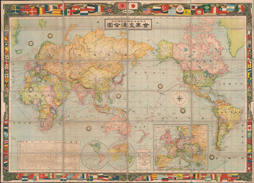
世界交通全图 / World Traffic Map. / Sekai kōtsū zenzu.
sold
- Digital Map Information
- Suitable for large format printing
- Full resolution TIFF file
- ICC color profile embedded
- Delivered instantly via download link
An exceptional 1909 or Meiji 42 Osaka Daily News Agency map of the world on Mercator's Projection. The map embraces an art nouveau aesthetic with regard to its decorative borders, which incorporate the flags and ensigns of the world's powers, among them the Azure Dragon flag of the Qing. The whole is centered on Japan and the Pacific and includes shipping routes throughout the world. Statistical tables in the lower quadrants advance detail regarding the land, population, fiscal revenue, and armaments of each nation. (more details)
The finest 19th century map of the Mont Blanc Range.
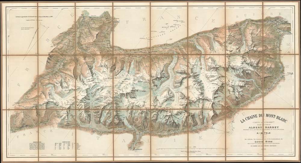
Le Chaine du Mont-Blanc.
sold
- Digital Map Information
- Suitable for large format printing
- File Size: 50.21 MB
- File Type: ZIP / TIFF
- ICC color profile embedded
- Delivered instantly via download link
Generally known as 'The Imfeld Map', this is a dramatic and stunning 1896 Xaver Imfeld chromolithograph map of the Mont Blanc Mountain Range in Switzerland's Alps - at the time the finest map of the region yet produced. The map is oriented slightly to the northwest and is centered on the peak of Mont Blanc itself. Coverage extends from Bon-Nant River in France to Orsières and from Gillot to Courmayeur. The map was highly praised when it was produced by journals of the time,
To this faultless production all explorers of the Chian are deeply indebted, and for the first time the Mont du Brouillard, the Glacier du Mont Blanc, the Rochers du Mont Blanc, the Glacier du Dôme, and the Aiguilles Grises are all beautifully delineated with scrupulous fidelity to nature. (Mathews, C. E., Annals of Mont Blanc, page 216)The whole employs the unique Swiss-style shading techniques employed by the engraver, Kümmerly, to display that country's intense topography. (more details)
Spectacular wall map of the Burgundy Wine Region, France.

Carte du Duché de Bourgogne, Comtés et Pays adjacents dressée par Ordre de M.M. les Elus Généraux de la Province.
sold
- Digital Map Information
- Suitable for large format printing
- DPI: 600
- File Size: 153.05 MB
- File Type: ZIP / TIFF
- ICC color profile embedded
- Delivered instantly via download link
An utterly stunning large format 1782 wall map of the Burgundy (Bourgone) wine region of France. Prepared for provincial administrative purpose, this map covers the full Burgundy region known for producing some of the world's greatest wines from the Champagne ... (more details)
Depicts the current situation in the Pacific and includes a vivid vignette of the Japanese attack on Pearl Harbor.
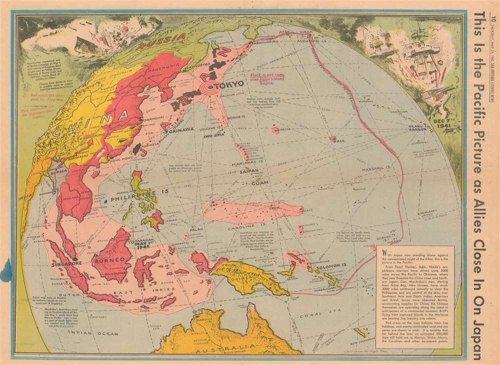
This is the Pacific Picture as Allies Close in on Japan.
sold
- Digital Map Information
- Suitable for large format printing
- File Size: 26 MB
- File Type: ZIP / TIFF
- ICC color profile embedded
- Delivered instantly via download link
This is a 1945 Charles Owens map of the Pacific highlighting the current state of affairs in the Pacific War only a couple weeks after Allied victory in Europe. In a style reminiscent of Richard Edes Harrison, the map depicts the region from China and India to Hawaii and from the Aleutian Islands and Russia to Australia. Owens uses color highly effectively to convey the areas of Japanese invasion (dark red), and influence (pink) to provide the viewer with immediate understanding of just how much territory the Japanese still control, even after victory was achieved in Europe. (more details)
A bird's eye view of the St. Louis World's Fair which hosted the debut of Dr. Pepper.

Panorama of the World's Fair, St. Louis, 1904.
sold
- Digital Map Information
- Suitable for large format printing
- File Size: 12.49 MB
- File Type: ZIP / TIFF
- ICC color profile embedded
- Delivered instantly via download link
This is a 1904 George W. Melville bird's-eye view or map of the St. Louis World's Fair, also known as the Louisiana Purchase Exposition. The view is centered on the Art and Statuary Exhibit Palace or main exhibition center. Each of the state buildings, special buildings, foreign pavilions, and special attractions are numerically labeled and correspond with the index on the verso. (more details)
Celebrates aviation pioneers and their incredible accomplishments and traces the routes of early airlines.
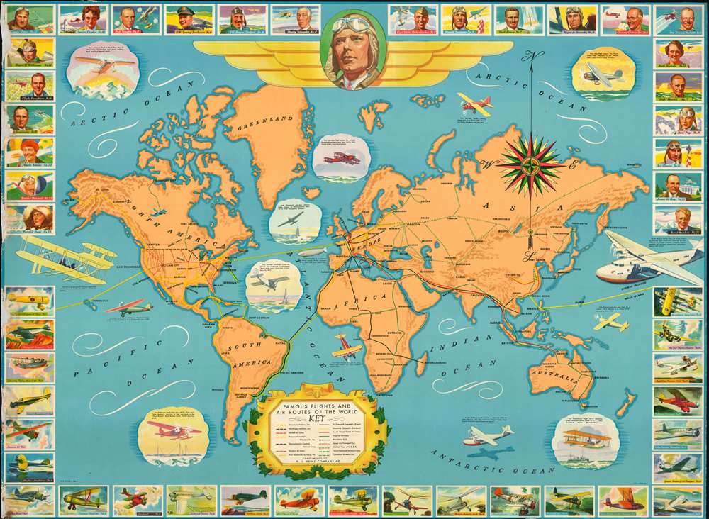
Famous Flights and Air Routes of the World
sold
- Digital Map Information
- Suitable for large format printing
- File Size: 72.59 MB
- File Type: ZIP / TIFF
- ICC color profile embedded
- Delivered instantly via download link
This is a 1937 H.J. Heinz Company pictorial map of the world promoting aviation milestones and air travel. The map depicts the world from the Americas to Australia and New Zealand and from the Arctic Ocean to the Antarctic Ocean. Aviation milestones are celebrated by views situated throughout. Charles Lindbergh's flight across the Atlantic, for example, is highlighted by a view of the Spirit of St. Louis (his airplane) and the Eiffel Tower placed in the middle of the Atlantic Ocean. Other historic flights include the first flight over the North Pole, the first flight over the South Pole, the first non-stop Pacific crossing from Japan to the United States, and the first solo flight around the world. The largest illustration, a Boeing flying boat situated along the right border, promotes the trans-Atlantic Air Service flown by Pan American. The famous Pan American Clipper also makes an appearance, illustrated near the bottom border in the Antarctic Ocean. Routes flown by the airlines of the era, including American Airlines, Air France, Pan American, K.L.M., and Imperial Airways are traced by lines of different colors and patterns. The Civil Air Trust of the U.S.S.R. is also noted. The whole is surrounded by a pictorial border consisting of portraits of famous aviators and illustrations of airplanes. A large portrait of Charles Lindbergh appears at top center and some of the other pilots appearing in the frame along the top include Eddie Rickenbacker, Louise Thaden, Clyde Pangborn, Jimmie Doolittle, and Ruth Nichols. The planes are illustrated along the bottom, with the Lockheed Model 10 Electra, the plane flown by Amelia Earhart when she disappeared over the Pacific, a Douglas DC-2, A Curtis-Wright Condor, several flying boats, and an autogiro. (more details)
Scarce 1943 Bird's Eye View of Wellesley College
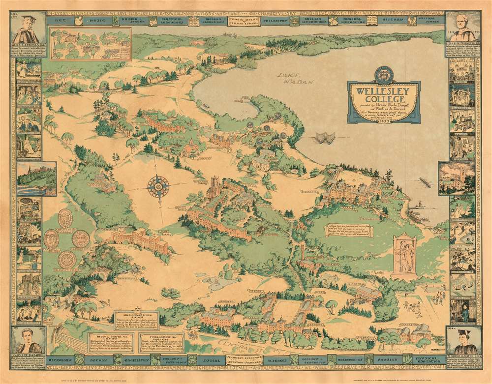
Wellesley College, founded by Henry Fowle Durant and Paulina A. Durant, 'Nisi Dominus aedificaverit domum, in vanum laboraverunt qui aedificant eum' 1875.
sold
- Digital Map Information
- Suitable for large format printing
- File Size: 31.27 MB
- File Type: ZIP / TIFF
- ICC color profile embedded
- Delivered instantly via download link
This is a 1943 Rosalind Howe Sturges pictorial map of the campus of Wellesley College, Massachusetts. Sturges lived in Wellesley in the early 40s, and given the deep knowledge of college shibboleths exhibited in this map, she appears to have had a close connection to the school. (This writer has been defeated in his efforts to learn the meaning of 'Going Through Harriet.') The outer border displays the school's Alma Mater, while the inner border at top and bottom list the various academic programs offered. Each corner honors one of four college presidents - the three remaining ones, to date, are similarly eulogized in text boxes within the map. The fine cartouche decorated with the college seal, and a motto:
A series of vignettes - drawn from photographs for the most part - highlight signal events in the College's history, as well as activities familiar to the Wellesley graduate but obscure to outsiders. (more details)
Nisi Dominus aedificaverit domum, in vanum laboraverunt qui aedificant eum : Unless God builds the house, its builders work in vain.The composition is oriented to the south (as indicated with an elegant compass rose). Central Street forms the bottom limit of the map, with Lake Waban dominating the background. Amongst the campus' woods and fields are shown the College's buildings, with sharp architectural accuracy. Each is named - or in some cases, marked with symbols. For example, buildings associated with academic societies are marked with their emblems, and the College's Shakespeare society is marked with a thespian's mask. Students are pictured throughout the composition: some merely walking to and fro, but a crowd of mortarboarded graduates troops into Alumnae Hall, and groups of students can be seen at play: field hockey, lacrosse, tennis, badminton and rowing can all be found on the map.
A series of vignettes - drawn from photographs for the most part - highlight signal events in the College's history, as well as activities familiar to the Wellesley graduate but obscure to outsiders. (more details)