
Steven J. Pieragastini
A scholar of modern Chinese and world history, drawn to maps of East Asia and beyond the Western tradition.
I come to Geographicus from a background in academia, focused on modern Chinese and world history — which naturally draws me to maps of and from East Asia. I'm also drawn to Russian/Soviet maps, Ottoman maps, and maps from non-Western languages or cartographic traditions.
These maps are exciting because they offer alternative perspectives — not just on historical events, but on geographic knowledge itself, and even on what counts as a "map." They're also generally less cataloged and less familiar to the trade, which means real opportunities to introduce new material for collectors and scholars alike.
Monthly Digest of Steven's Picks

Largest and Most Detailed Early-19th Century Map of China.

This is a massive (98 x 134 in) 64-sheet 1832 wall map of Qing China, prepared by Dong Fangli and Li Zhaoluo. Building on administrative maps of the early-mid Qing, it represented the most detailed and accurate mapping of China and surrounding territories under Qing suzerainty produced in the early 19th century. (more details)
Battle for the Fate of the Levant.
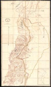
ردشمنلوا میسرت كنویامه هیرب هناخسدنهم هطیرح وبشا [This map was drawn by the Imperial Engineering Office].
$20,000.00
Acquire
- Digital Map Information
- Suitable for large format printing
- Full resolution TIFF file
- ICC color profile embedded
- Delivered instantly via download link
An extraordinary, one-of-a-kind large-format manuscript folding map of Ottoman Syria produced by the sultan's Imperial Engineering Office c. 1832. It was made in the context of the First Egyptian Ottoman War (1831 - 1833), which saw the region temporarily come under Egyptian rule. (more details)
The first official Japanese regional map using western cartographic technology. A wonder of copper engraving!

峨羅斯及亞西亞ノ圖 / [Map of Russia and Asia].
$12,000.00
Acquire
- Digital Map Information
- Suitable for large format printing
- File Size: 109.25 MB
- File Type: ZIP / TIFF
- ICC color profile embedded
- Delivered instantly via download link
An extraordinary 1867 (Keio 3) map of Siberia and Alaska illustrates a moment of cultural collision and transformation. Printed in Japan using a remarkable multi-color copperplate process, the map is a conic projection covering Asia from the Caspian Sea to the Bering Strait. It extends farther east to include Alaska, and south to encompass Nepal, Korea, Tibet, most of China, and all of Japan. This is the first Japanese regional map to incorporate contemporaneous western cartographic technology for official strategic and military use. (more details)
Japanese diplomatic and propaganda con-job on the Qing.
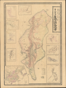
Detailed Map of Taiwan Field Survey. / 實地踏測台灣詳密地圖
$11,000.00
Acquire
- Digital Map Information
- Suitable for large format printing
- Full resolution TIFF file
- ICC color profile embedded
- Delivered instantly via download link
This 1895 Nakamura Yoshimatsu map of Taiwan is one of the most unsung but influential examples of persuasive cartography ever published. The large-scale map of Taiwan appeared at the end of the First Sino-Japanese War (August 1, 1894 - April 17, 1895), just prior to the Treaty of Shimonoseki (April 17, 1895) and the Japanese invasion of Taiwan (May 29, 1895 - October 21, 1895). The map, attributed to a likely fictional British naval officer named John Waters, employs creative cartography to reshape Taiwan, while retaining the overall area, effectively reducing the size of Qing-controlled Formosa and increasing the size of the ungoverned 'savage zones' - a ploy that played into the Japanese position that the Qing did not truly possess the island. It was likely presented at the Shimonoseki negotiations, where the Japanese were able to take advantage of Qing China's infamous lack of cartographic knowledge about Formosa to formally seize the island. This is the first edition of this map, published on January 20, 1895. It also accompanies the booklet Taiwan-tō Chishi-yō (臺灣島地誌撮要), a combination gazetteer of Taiwan and historiographical justification of the Japanese seizure of the island using Confucian political morality and just-war rhetoric. (more details)
Saudi map of the Arab World in transition.
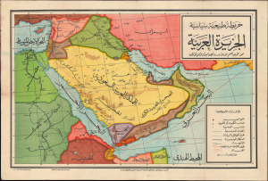
الْجَزِيرَةُ الْعَرَبِيَّةُ خَرِيطَةٌ طَبِيعِيَّةٌ سِيَاسِيَّةٌ / [The Arabian Peninsula A Physical and Political Map].
$9,500.00
Acquire
- Digital Map Information
- Suitable for large format printing
- Full resolution TIFF file
- ICC color profile embedded
- Delivered instantly via download link
This is a c. 1950 Mohamed Abdelmonem Arabic-language wall map of the Middle East, printed by the Egyptian Mustafa al-Babi al-Halabi and Sons Press. It is recorded as being approved by the 'Directorate of Education in the Kingdom of Saudi Arabia,' suggesting that it was intended for classroom use in the kingdom. (more details)
Arab World in the Wake of World War II.
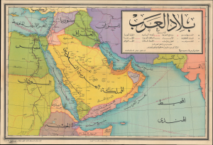
بلاد العرب / [Arab Lands].
$9,500.00
Acquire
- Digital Map Information
- Suitable for large format printing
- Full resolution TIFF file
- ICC color profile embedded
- Delivered instantly via download link
This is a rare c. 1950 Arabic-language wall map of the Arab World, prepared by Ahmed Al-Bajuri and published by Mustafa Al-Babi Al-Halabi and Sons. It presents the region in the wake of World War II (1939 - 1945), as European colonial empires collapsed and Arab nations gained independence. (more details)
Cold War Era Soviet Plan to Repel an American Arctic Invasion.

Организация и ведение противодесантной операции на морском побережье во взаимодействии с военно-морским флотом / [Organization and Conduct of an Anti-Amphibious Operation on the Seacoast in Coordination with the Navy].
$7,500.00
Acquire
This is a one-of-a-kind 1952 Cold War Era top-secret report with maps, prepared for the Operations Directorate of the Northern Military District of the Armed Forces of the Soviet Union. The booklet discusses detailed plans to repel a much-feared 'Anglo-American imperialist' invasion of the Soviet Union from the Arctic. It offers unique insight into the Soviet perspective and defensive planning at the height of the Cold War (1947 - 1991). (more details)
Making Light of Perry's Gunboat Diplomacy.
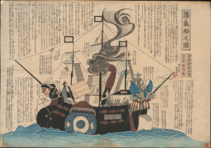
陽氣舩之圖 / [View of the Merry Ship].
$6,500.00
Acquire
- Digital Map Information
- Suitable for large format printing
- Full resolution TIFF file
- ICC color profile embedded
- Delivered instantly via download link
This is a rare c. 1854 kawaraban satirical woodblock print, produced by the pseudonymous Kanoka Mamaro (寒翁窠馬麿), depicting one of Commodore Matthew Perry's 'black ships.' It demonstrates that, even amid a strict regime of censorship, Japanese publishers sought to profit by informing and entertaining the public, including with irreverent takes on the historically significant events underway. (more details)
Ornate Wartime Bird's-Eye View of Mecca.
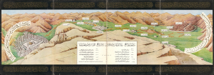
رسم مشاعر الحج : نقلا عن كتاب مراة الحرمين لأمير الحج اللواء ابراهيم رفعت باشا / [Depicting the Emotions of Hajj: Excerpted from the book Mir'at al-Haramayn by the Commander of the Hajj Caravan, Major General Ibrahim Rifaat Pasha].
$6,000.00
Acquire
- Digital Map Information
- Suitable for large format printing
- Full resolution TIFF file
- ICC color profile embedded
- Delivered instantly via download link
This is a c. 1942 decorative Hajj souvenir view of the Muslim holy city of Mecca (Makkah) and surroundings, based on the work of Ibrahim Rifat Pasha. Taking in the Kabaa, the Great Mosque, and the Plain of Arafat, it would have been intended for a Hajji to remind them of the apex and core ritual components of their pilgrimage. (more details)
Foreigners so strange.
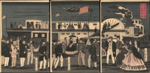
亜墨利加國蒸気車往來 / [The Comings and Goings of an American Steamship].
$5,500.00
Acquire
- Digital Map Information
- Suitable for large format printing
- Full resolution TIFF file
- ICC color profile embedded
- Delivered instantly via download link
This is Utagawa Yoshikazu's 1861 ukiyo-e woodblock triptych of an American steamship and passengers at Yokohama, an intriguing depiction of foreigners in Japan from the early days after Yokohama's opening as a treaty port. It is notable for reflecting both the curiosity of Japanese artists about the new arrivals and their imperfect understanding of these visitors. (more details)
Japan's first train.
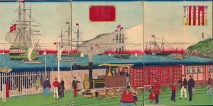
橫濱往返鐵道蒸氣車海上之圖 / [View of Steam Engine on the Seaside Yokohama Line].
$4,500.00
Acquire
- Digital Map Information
- Suitable for large format printing
- Full resolution TIFF file
- ICC color profile embedded
- Delivered instantly via download link
A fascinating 1874 ukiyo-e triptych by Utagawa Hiroshige III celebrating Japan's first passenger railway and the astonishing modernization of Yokohama under the Meiji. Opened between Yokohama and Tokyo in 1872, the steam railway became one of the most potent symbols of a country transforming itself at extraordinary speed, linking Japan's leading international treaty port with the imperial capital. Published two years after the railway's inauguration, the triptych captures not simply a train, but a defining moment in the Meiji Restoration, when foreign technology was being rapidly absorbed and transformed into the infrastructure of modern Japan. (more details)
Tokyo's Foreign Quarter in the Early Meiji Period.
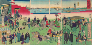
東京繁榮流行の往来 / [The Comings and Goings of Prosperity and Fashions in Tokyo].
$4,500.00
Acquire
- Digital Map Information
- Suitable for large format printing
- Full resolution TIFF file
- ICC color profile embedded
- Delivered instantly via download link
This is an 1870 ukiyo-e depiction of the Tsukiji neighborhood of Tokyo, drawn by Utagawa Hiroshige III and published by Masadaya Heikichi. It displays the neighborhood just months after it was designated as the foreign residence quarter of Tokyo following the Meiji Restoration, emphasizing the rapid importation of foreign technologies, fashion, and manners. (more details)
Planning the Colonial Capital.
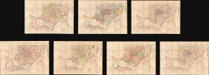
附圖第一號 京城都市計畫區域圖, 附圖第二號 京城都市計畫地域圖... / [Appendix Map No. 1. Keijo Capital City Plan Area Plan, Appendix Map No. 2. Keijo Capital City Plan Land Use Map...].
$4,500.00
Acquire
- Digital Map Information
- Suitable for large format printing
- Full resolution TIFF file
- ICC color profile embedded
- Delivered instantly via download link
This is a set of seven large-format c. 1925 planning maps of Seoul (Keijō), produced during the Japanese colonial period. Together, they constitute a remarkable survival from the Japanese colonial era and provide a window into a forgotten chapter in the history of one of the world's largest cities. (more details)
A lost map...
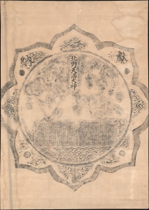
北野天満大神 / [The Great 'Kami' of Kitano Shrine].
$4,500.00
Acquire
- Digital Map Information
- Suitable for large format printing
- File Size: 87.3 MB
- File Type: ZIP / TIFF
- ICC color profile embedded
- Delivered instantly via download link
This is a unique rubbing of a Meiji 13 or 1880 map of the Eastern Hemisphere from a carving on the back of a bronze mirror at Kitano Tenmangū Shrine, Kyoto. The mirror and the map were given by the Nissan Nagamori-kō to the Kitano Tenmangū Shrine in 1880. Nonetheless, the map was forgotten until 2015, when it was rediscovered by shrine caretakers, but this rubbing dates to the early Meiji, shortly after the mirror-map was carved. This rubbing was thus likely done for or by one of the Nissan Nagamori-kō, or possibly a pilgrim to the shine shortly after it was donated, but before the mirror was mounted - hiding the map and making all further rubbings impossible. (more details)
Yokohama emerging as an international port.
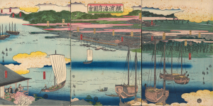
橫濱海岸圖會 / [View of the Coast at Yokohama.]
$4,000.00
Acquire
- Digital Map Information
- Suitable for large format printing
- Full resolution TIFF file
- ICC color profile embedded
- Delivered instantly via download link
An early 1860 ukiyo-e triptych by Utagawa Hiroshige II, capturing Yokohama, Japan, as it emerged as an international treaty port. Published just months after Yokohama opened to foreign trade in 1859, this panoramic view presents a city poised between the insular world of Tokugawa Japan and the profound transformations that would soon accompany sustained contact with the West. Among the earliest printed views of Yokohama, it offers a Japanese vision of the nascent port: cherry blossoms, temples, teahouses, theaters, and the notorious Miyozaki pleasure quarter occupy a landscape only beginning to accommodate global commerce. Most evocative is a woman seated in a waterfront teahouse, telescope in hand, gazing across the harbor - an image that seems to encapsulate Japan itself, watching with fascination as an unfamiliar world approaches. (more details)
High Point of Egyptian-Saudi Relations.
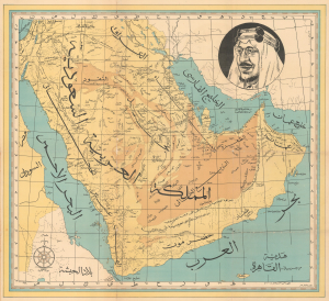
This is an unrecorded c. 1955 Arabic-language map of Saudi Arabia prepared by the Al-Ragha'ib Press in Egypt. It was issued during a warm period of Egyptian-Saudi relations, before the two countries became leaders of opposing blocs in the Arab Cold War. (more details)
Japan's First True Railway.
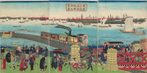
東京高輪海岸蒸氣車鐵道圖 / [Steam Train on the Railway along the Tokyo-Takanawa Coastline].
$4,000.00
Acquire
- Digital Map Information
- Suitable for large format printing
- Full resolution TIFF file
- ICC color profile embedded
- Delivered instantly via download link
A remarkable view of Japan's first modern railway, this ukiyo-e woodblock triptych was drawn by Utagawa Hiroshige III and published by Tsunajima Kamekichi in 1871. (more details)
The Rapid Expansion of Yokohama.
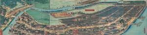
再改橫濱風景 / [Up-to-date View of Yokohama].
$4,000.00
Acquire
- Digital Map Information
- Suitable for large format printing
- Full resolution TIFF file
- ICC color profile embedded
- Delivered instantly via download link
This is a stunning 1861 panoramic set of six ukiyo-e (nishiki-e) Utagawa Sadahide woodblock prints depicting the port of Yokohama. The port opened to foreign trade in 1859, just two years earlier, becoming Japan's primary point of contact with the West. Sadahide was the most prolific among a school of woodblock artists chronicling these momentous changes. (more details)
Early Japanese connections with San Francisco.

亜墨利迦州迦爾波爾尼亜港出帆之圖 / [View of Ships Departing from the Port of California, America].
$4,000.00
Acquire
- Digital Map Information
- Suitable for large format printing
- Full resolution TIFF file
- ICC color profile embedded
- Delivered instantly via download link
A magnificent Ukiyo-e woodblock triptych in the distinctive Yokohama-e style, produced in 1862 by the genre's most prolific master, Utagawa Sadahide. It portrays a group of American ships leaving the 'port of California,' almost certainly San Francisco, presumably bound for Japan. This work is especially notable as it depicts a purely foreign scene, rather than the more common illustrations of foreigners in Yokohama or elsewhere in Japan. (more details)
Celebrating the Hejaz Railway from Damascus to Medina.
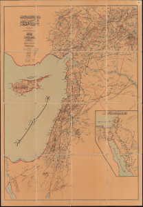
سوریه قطعهسی / [The Region of Syria].
$3,750.00
Acquire
- Digital Map Information
- Suitable for large format printing
- Full resolution TIFF file
- ICC color profile embedded
- Delivered instantly via download link
This exceptionally rare c. 1912 Ottoman folding map of the Levant highlights the Hejaz Railway. Across scorching deserts, waterless expanses, and some of the most unforgiving terrain on earth, the Ottoman Empire forged one of the Islamic world's great engineering achievements: the Hejaz Railway. Financed without European loans through contributions from Muslims around the globe and constructed increasingly by Ottoman engineers and Muslim workers, the line reached more than 1,300 kilometers from Damascus to Medina (المدينة) by 1908. (more details)
Passion for foreign technology.
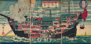
獨逸國軍艦内郭機械圖 / [Drawing of the Internal Workings of a German Navy Ship].
$3,500.00
Acquire
- Digital Map Information
- Suitable for large format printing
- Full resolution TIFF file
- ICC color profile embedded
- Delivered instantly via download link
A scarce c. 1874 ukiyo-e (more specifically, nishiki-e) triptych depicting lively scenes aboard a German naval ship, prepared by the artist Unsen. It is an example of Japan's flourishing interest in foreign technology and practices in the early Meiji period and specifically represents the special connection between the Prussian-led German Empire and the Empire of Japan. (more details)
Yokohama's Yoshiwara.
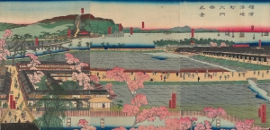
横浜港崎町大門橋真景 / [An Accurate View of the Miyozaki Great Gate and Bridge in Yokohama].
$3,500.00
Acquire
- Digital Map Information
- Suitable for large format printing
- Full resolution TIFF file
- ICC color profile embedded
- Delivered instantly via download link
This is a ukiyo-e triptych of Yokohama, prepared in 1860 by Sadahide, the master of the Yokohama-e subgenre of ukiyo-e woodblock prints. It depicts a view from the Miyozaki pleasure quarter, one of the main sites of cultural contact and mutual curiosity between foreigners and Japanese in Yokohama. (more details)
Buddhist Pilgrim's Progress.

山西汾州府介休縣綿山抱腹巗圖 / [View of Baofu Cliff, Mianshan, Fenzhou Prefecture, Jiexiu County, Shanxi].
$3,200.00
Acquire
- Digital Map Information
- Suitable for large format printing
- Full resolution TIFF file
- ICC color profile embedded
- Delivered instantly via download link
A rare and likely unique survival, this is a 1890 Buddhist pilgrim map, drawn and printed by monks, depicting the Yunfeng Temple (雲峰寺) and associated Buddhist and Daoist sites on Mianshan (绵山), Shanxi, China. These ephemeral works provide uncommon insight into the religious life of the late Qing era, much of which has been lost due to China's destructive 20th-century wars and revolutions. (more details)
American - Chinese - Japanese exchange in Yokohama.
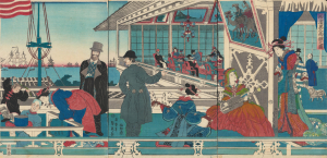
橫濱異人商館之圖 / [View of Foreign Merchant House in Yokohama].
$3,000.00
Acquire
- Digital Map Information
- Suitable for large format printing
- Full resolution TIFF file
- ICC color profile embedded
- Delivered instantly via download link
An absorbing 1861 depiction of Japanese-foreign interactions in Yokohama, this ukiyo-e triptych was prepared by Sadahide, the great chronicler of the treaty port in its early years, and published by Sanoya Kihei. It is notable, among other features, for revealing the three-way exchange between Westerners, Chinese, and Japanese in Yokohama. (more details)
Ottoman Preparations for the 'Last Stand' in the Levant.

يلديرم اردولر غروپى نزد مؤسسه مؤسسات صحيه و حيوانيهسى مشروحدور / [The medical and veterinary institutions and establishments attached to the Yıldırım Army Group are detailed here].
$3,000.00
Acquire
- Digital Map Information
- Suitable for large format printing
- Full resolution TIFF file
- ICC color profile embedded
- Delivered instantly via download link
This is a rare and likely unique c. 1918 large-format Ottoman military resource map of the Levant prepared by the Yıldırım Orduları Grubu (Lightning Armies Group), the elite field command established to halt the advancing British Empire and its Arab allies during the final stages of World War I (1914-1918). Combining printed cartography with handstamps and manuscript annotations, the map inventories the region's strategic infrastructure, emphasizing hospitals, medical depots, supply centers, transportation networks, and other critical military resources essential to sustaining Ottoman operations. Intended for high-level logistical planning rather than tactical battlefield use, such a comprehensive assessment of military assets would have been among the Ottoman Empire's most closely guarded wartime documents, offering an extraordinary glimpse into the administrative and logistical foundations of the Palestine Campaign. (more details)
Mapping Taiwan, with an Eye towards Expansion.
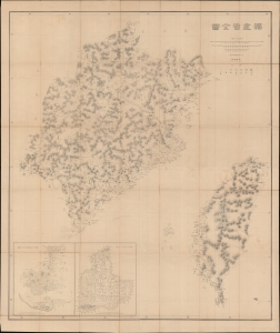
福建省全圖 / [Complete Map of Fujian Province].
$3,000.00
Acquire
- Digital Map Information
- Suitable for large format printing
- Full resolution TIFF file
- ICC color profile embedded
- Delivered instantly via download link
This is a rare c. 1882 large-format folding map of Fujian and Taiwan, produced by the General Staff of the Japanese Imperial Army. Made in the wake of Japan's 1874 Punitive Expedition to Taiwan, this map presages the 1895 conquest and colonization of Formosa. (more details)
An Early View of Yokohama's Red-Light District.
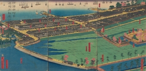
橫濱本町景港崎街新廓 / [View of Yokohama Honmachi and the New Miyozaki Quarter].
$3,000.00
Acquire
- Digital Map Information
- Suitable for large format printing
- Full resolution TIFF file
- ICC color profile embedded
- Delivered instantly via download link
This is a c. 1860 ukiyo-e triptych of Yokohama highlighting, among other elements, the Miyozaki Pleasure Quarter, prepared by Sadahide and published by Yamaguchiya Tōbei. The city, hitherto a small fishing village, rapidly developed after being opened to foreign traders and residents in 1859, building new districts, including Miyozaki, in a handful of months. (more details)
Defending the borders in the wake of Commodore Perry.
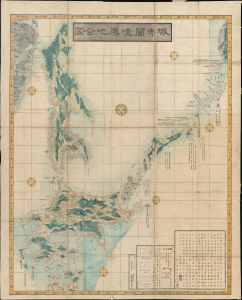
蝦夷闔境輿地全圖 / [Complete Map of All Lands within the Borders of Ezo].
$2,750.00
Acquire
- Digital Map Information
- Suitable for large format printing
- Full resolution TIFF file
- ICC color profile embedded
- Delivered instantly via download link
This is an important 1854 (Kaei 7) Japanese Edo period Fujita Ryou chromoxylographic map illustrating Hokkaido, Sakhalin, and the Kuril Islands. It was issued following the 1853 arrival of Commodore Matthew Perry, anticipating the opening of Hakodate as one of the five Japanese treaty ports. (more details)
Building Dams and Identity
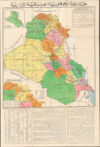
خارطة الجمهورية العراقية الإدارية / [Administrative Map of the Republic of Iraq]. / [Verso title panel] دَلِيل السَّائِح وَالطَّالِب وَالمُوَاطِن فِي خَارِطَة عِرَاقِنَا الحَضَارِي [Guide for the Tourist, Student, and Citizen to the Map of Our Cultural Iraq].
$2,500.00
Acquire
This is a 1972 Arabic-language wall map of Iraq prepared by Tuma Al-Sadi, a high-level bureaucrat in the Ba'athist government, and printed by the General Directorate for Survey. Packed with information, it covers everything from irrigation projects (the main focus of the General Directorate for Survey) to resorts, historical landmarks, tourist riverboats, and other information relevant to tourists. These dual purposes - highly technical on the one hand and leisurely on the other - seem an odd pairing but make sense within the context of the ambitious goals set by the Ba'athists. (more details)
Geographical Games.
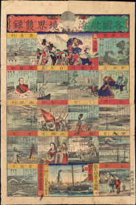
各國航海境界雙錄[六] / [Sugoroku of Each Country's Maritime Boundaries].
$2,250.00
Acquire
- Digital Map Information
- Suitable for large format printing
- Full resolution TIFF file
- ICC color profile embedded
- Delivered instantly via download link
A brilliantly-colored game from the early Meiji, this c. 1870 ukiyo-e sugoroku sheet reflects the interests of the times, focusing on foreign countries and modern naval technology. (more details)
Ottoman Irredentism in Africa.

مفصل افريقا خريطة / [Detailed Map of Africa].
$2,000.00
Acquire
- Digital Map Information
- Suitable for large format printing
- Full resolution TIFF file
- ICC color profile embedded
- Delivered instantly via download link
This is a rare, large-format Ottoman Turkish wall map of Africa, produced c. 1908 by the empire's Ministry of Public Education. It reflects the efforts of Ottoman reformers to disseminate geographic knowledge through the education system while also reinforcing pride in the empire through irredentism and maximalist territorial claims. (more details)
Colonial Modernity - the nexus of exploitation and cultural assimilation.

臺北州管内圖 / 1936 Showa 11 Taipei [Taihoku] Prefecture Administrative Map.
$1,800.00
Acquire
- Digital Map Information
- Suitable for large format printing
- Full resolution TIFF file
- ICC color profile embedded
- Delivered instantly via download link
An important and enlightening administrative map of Taipei (Taihoku) Prefecture during the Japanese colonial period, with unique and enlightening manuscript content. The map reflects the ambition of Colonial Modernity, when Taiwan was being developed as a 'model colony'. It illustrates the overlap between resource extraction, environmental management (specifically water), policing, and cultural assimilation. (more details)