
Vietnam by the American military newspaper Stars and Stripes.
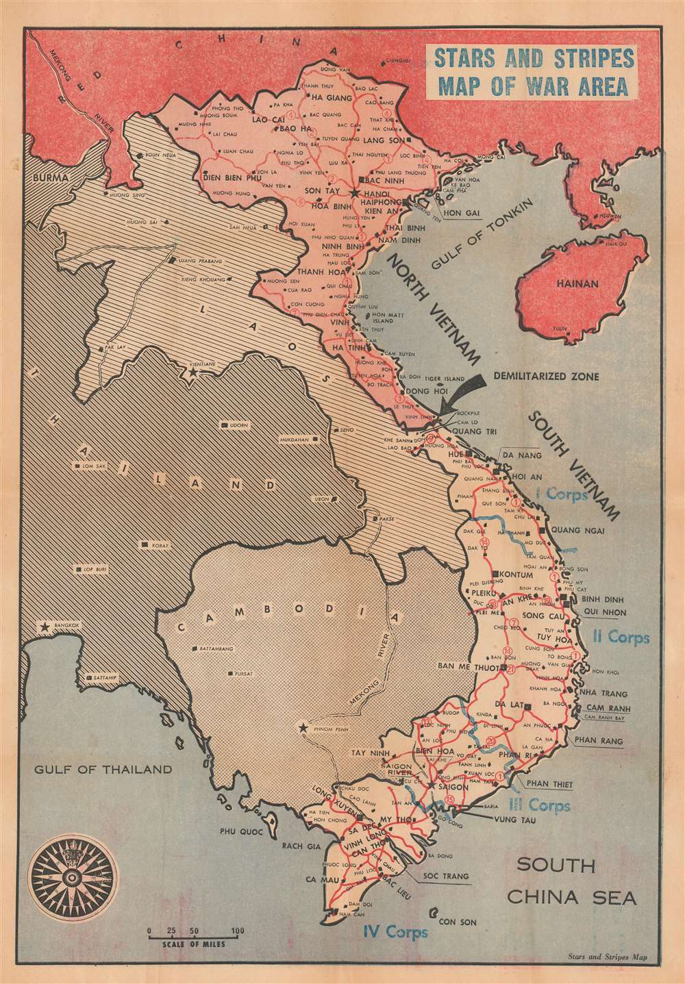
Stars and Stripes Map of War Area.
sold
This is a c. 1966 Stars and Stripes map of Vietnam during the Vietnam War. Vietnam is divided into North and South Vietnam, and a large black arrow emphasizes the intervening Demilitarized Zone. Cities, towns, and villages are labeled throughout, including Hanoi, Haiphong, Da Nang, and Saigon. Blue text and lines identify American military districts in South Vietnam. Laos, Thailand, and Cambodia are also included. (more details)
Chinese Mao Zedong propaganda celebrating the French student strike and general strike of May 68.

法国人民革命斗争示意图 / Sketch of the Revolutionary Struggle of the French People. 法国地图 / Map of France.
sold
This is a May 1968 Communist Chinese propaganda broadside map of France, celebrating the 'May 68' French student and general strikes. Published by the Xinhua Bookstore, maps of France are printed on both sides. A map with icons celebrating the students and workers striking throughout France appears on one side. The worker and the student are illustrated arm in arm; icons of trains, ships, and airplanes allude to the complete standstill imposed upon France's transportation network by the strikes. A proclamation attributed to Mao Zedong and accompanied by his portrait is emblazoned across the top and declares the 'awakening' of the proletariat and workers worldwide alongside the imminent demise of U.S. imperialism and other 'pests.' The broadside then goes on to detail how the French 'have set off a huge storm of revolutionary struggle' and that 'more than 10 million workers have launched a strike that shocked the capitalist world.' An inset on the left situates France in Europe, providing its Chinese audience with some idea of where this struggle is taking place. The map of France on the verso details the French railway system, and another quotation from Mao predicts the imminent collapse of colonialism, imperialism, and all exploitation systems. (more details)
Zionism! Jewish-owned land in British Palestine. Proof state.

EREZ ISRAEL ארץ ישראל
sold
- Digital Map Information
- Suitable for large format printing
- File Size: 33.51 MB
- File Type: ZIP / TIFF
- ICC color profile embedded
- Delivered instantly via download link
This is the proof state of the c. 1925 Jewish National Fund Zionist map of Jewish land in Palestine highlights the Jewish National Fund's (JNF) push to acquire land in Palestine for Jewish settlement. Areas shaded red indicate land owned by the JNF where it established Jewish settlements. Although unclear from reading the map, the JNF likely founded many of the smaller settlements identified. Major cities outside the areas are identified, including Jerusalem, Bethlehem, Tel Aviv, Jaffa, and Haifa. The JNF, founded as part of the early 20th-century Zionist movement, played a critical role in establishing Tel Aviv. Major highways (and possibly railroads) are illustrated as well. (more details)
Created to help Allied aviators evade capture after being shot down.

Luzon.
sold
- Digital Map Information
- Suitable for large format printing
- File Size: 58.35 MB
- File Type: ZIP / TIFF
- ICC color profile embedded
- Delivered instantly via download link
This is a 1944 Royal Australian Air Force (RAAF) silk escape map of Luzon, Philippines. Myriad cities and towns are labeled throughout Luzon and the island's road network is illustrated in detail. Two inset maps along the left border focus on Palawan (Inset 'B') and Yap Island (Inset 'C'). A third inset, situated along the top border, situates the three insets in relation to each other. (more details)
First detailed map of the Juruá River, one of the longest tributaries of the Amazon.
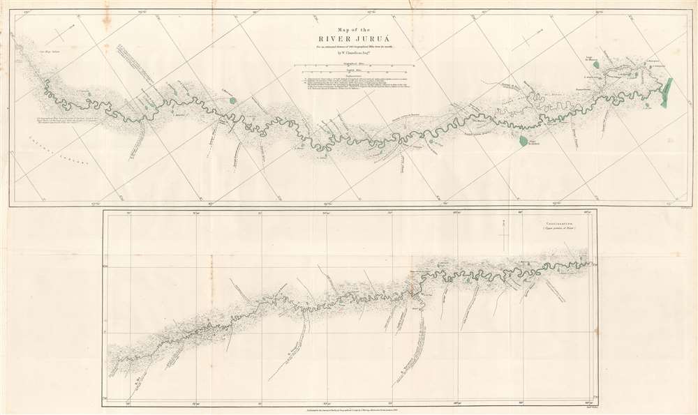
Map of the River Juruá.
$250.00
Acquire
- Digital Map Information
- Suitable for large format printing
- File Size: 13.33 MB
- File Type: ZIP / TIFF
- ICC color profile embedded
- Delivered instantly via download link
This is an 1869 William Chandless map of the Juruá River. The map divides the Juruá into two sections. The upper map illustrates the Juruá from its confluence with the Amazon to a point near Lake Ocoá. The lower map illustrates the upper portion of the river from Lake Ocoá to the point where the expedition reversed course. Small black crosses mark astronomical observations, and the dashed lines indicate the mouth of a lake or tributary. Chandless includes comments on the nature of the tributaries, and also notes the locations of the few tribal villages he encountered. (more details)
The first printed map of the Pacific Northwest.

[Africa/ Asia Maior/ Terra incognita]
sold
- Digital Map Information
- Suitable for large format printing
- Full resolution TIFF file
- ICC color profile embedded
- Delivered instantly via download link
This is a rare 1538 map of Asia, executed by Sebastian Münster for inclusion in his edition of Solinus' Polyhistor. It predates by two years the map of Asia in Münster's 1540Geographia. Although it is not entirely a modern work, it is the earliest printed map focusing on the continent of Asia. It also contains the first printed representation of the Pacific Northwest, more than thirty years prior to the Ortelius map generally granted that laurel. (more details)
An idyllic fantastical land created by Bernard Sleigh at the end of the Great War and which then stood in sharp juxtaposition to bomb-blasted Europe.

An Anciente Mappe of Fairy Land newly discovered and set forth.
sold
- Digital Map Information
- Suitable for large format printing
- Full resolution TIFF file
- ICC color profile embedded
- Delivered instantly via download link
An extraordinary 5-foot-long edition of Bernard Sleigh's 1918 fantastical map of Fairy Land. This fanciful map offers a wide birds-eye view style panorama of the island of 'Fairy Land' which it describes as 'newly discovered and set forth'. Fairy Land, as set for the by Sleigh, is a wonderful juxtaposition of European fairy tales, literature, and Greek mythology. One can travel from King Arthur's Tomb to Peter Pan's House to the 'Bay of Moaning,' or the visit the roost of Dragons, watch Perseus save Andromeda, chat with Hercules, or visit the 'Harbour of Dreamland.' There are in essence four sections, the leftmost section represents a Tolkien-like world of elves and dragons. This segues into a land populated by children's fairytales. The third section features figures from Arthurian legends and medieval myth. The rightmost, fourth, segment draws its inhabitants from Greek and Roman mythology. A red line indicates the route of passage 'From the World' to 'a place that never was and always will be.' (more details)
On the cusp of change.
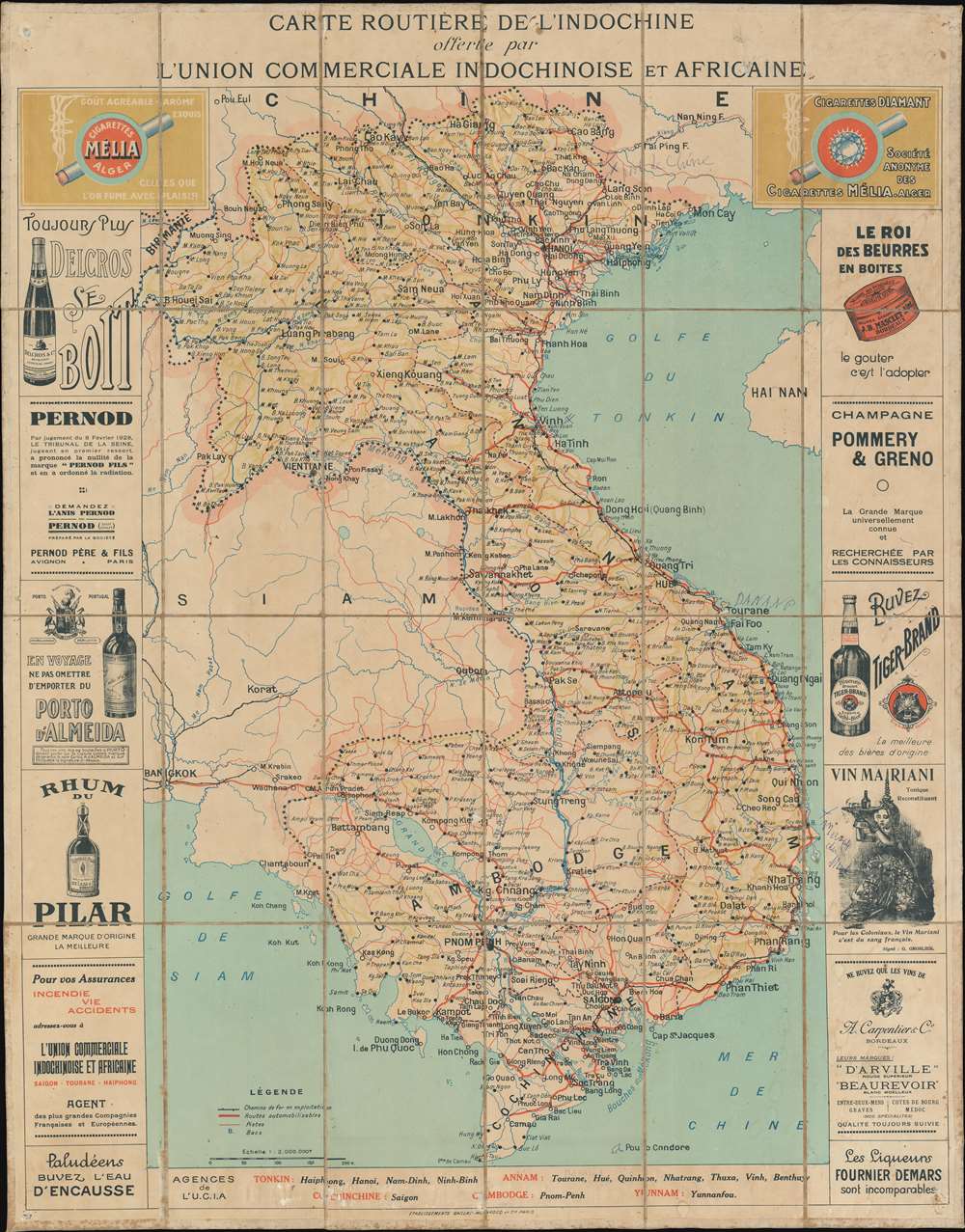
Carte Routière de L'indochine offerte par L'Union Commerciale Indochinoise et Africaine.
sold
- Digital Map Information
- Suitable for large format printing
- File Size: 48.3 MB
- File Type: ZIP / TIFF
- ICC color profile embedded
- Delivered instantly via download link
A visually striking c. 1928 large-scale folding chromolithograph map of Vietnam, then French Indochina, issued by L'U.C.I.A., Union Commerciale Indochinoise et Africaine. The map covers all of modern-day Vietnam, Cambodia, and Laos, as well as parts of adjacent Thailand (Siam). The focus of the map is on road networks within Indochina, but its most striking feature is the interesting advertising surrounding the map proper. (more details)
A view of the first Rush Street Bridge that was destroyed three years after it opened.

Rush Street Bridge Chicago in the Year 1861.
sold
- Digital Map Information
- Suitable for large format printing
- File Size: 13.09 MB
- File Type: ZIP / TIFF
- ICC color profile embedded
- Delivered instantly via download link
This is a 1929 Raoul Varin aquatint view of the Rush Street Bridge. The bridge occupies the foreground and a large crowd of people gather on the near end of the bridge. Buildings line the far bank, McCormick's Reaper Factory and the sugar refinery both identified. Sailing ships line both banks of the Chicago River and a steamship, name the Comet steams away from the bridge toward Lake Michigan. (more details)
The Chicago Water Tower - one of the few buildings to survive the Great Chicago Fire.

Chicago Water Works 1868.
sold
- Digital Map Information
- Suitable for large format printing
- File Size: 11.79 MB
- File Type: ZIP / TIFF
- ICC color profile embedded
- Delivered instantly via download link
This is a 1929 Raoul Varin aquatint view of the Chicago city waterworks and water tower as it appeared in 1868. Located on modern-day Michigan Avenue (called Pine Street in 1868), the Water Tower and the pump house survived the Great Chicago Fire of October 8-10, 1871. It stands 182.5 feet tall and housed a 138-foot high standpipe while it was operational. When Pine Street was widened in 1918, the plans were revised to give the Water Tower and the Chicago Avenue Pumping Station a featured location. (more details)
Signed view of the Chicago River and the Wells and Clark Street Bridges.

View of Wells and Clark St. Bridges 1861.
sold
- Digital Map Information
- Suitable for large format printing
- File Size: 14.86 MB
- File Type: ZIP / TIFF
- ICC color profile embedded
- Delivered instantly via download link
This is a 1929 Raoul Varin aquatint view of the Wells and Clark Street Bridges across the Chicago River in Chicago, Illinois. Looking west along the Chicago River, the Chicago Tobacco Works and the Western Transportation Company appear in the foreground. Boats line the Chicago River, and the span of the Clark Street Bridge is turned horizontally to allow a boat to pass. The Wells Street Bridge still spans the river and has not yet been swung upward for the boat. The top of the courthouse is visible over the buildings, along with the steeples of several churches. (more details)
The Three cities of Wuhan: Hankou, Hanyang, Wuhan.

[Three Towns of Wuhan] / 武汉三镇
sold
- Digital Map Information
- Suitable for large format printing
- File Size: 13.35 MB
- File Type: ZIP / TIFF
- ICC color profile embedded
- Delivered instantly via download link
A rare Japanese-issued October 1939 view of Wuhan drawn by Tsunemitsu Kaneko and issued in Shanghai by Zhiseitang. The view looks northwest on Wuhan, from a fictional high point far to the southeast, across the Yangtze River. The focus is the foreign concessions in the Hankou / Hankow district, but Wuchang and Hanyang are also represented. Full coverage extends west along the Yangtze as far as Chongqing, and east as far as Shanghai. The cartography reflects the strategic significance of the three towns of Wuhan, and textual content underscores Japanese owned businesses and facilities. The view follows shortly after the Battle of Wuhan and was issued for Japanese soldiers to send home to their families. (more details)
A Buffalo Soldier regiment.

Map of Land-Grant and Bond-Aided Railroads of the United States.
sold
- Digital Map Information
- Suitable for large format printing
- Full resolution TIFF file
- ICC color profile embedded
- Delivered instantly via download link
This is an 1892 U.S. Army Quartermaster General railroad map of the United States owned by Army Colonel David Dougall Van Valzah while he was in command of a Buffalo Soldier infantry regiment in New Mexico. The map depicts most of the continental United States from the Pacific Ocean to Maryland, Virginia, Pennsylvania, and New York and from Canada to Mexico. Issued with General Orders, No. 77 in 1892, black, green, and red lines trace land-grant and bond-aided railroads in the western United States. General Orders No. 77 outlined military procedures for 'compensating' the railroads for 'transporting United States troops and property.' The order, which the map accompanied, specified exact rates each of the concerned railroads was owed. The Adjutant General explained the map's inclusion in this way
As an aid to a clear and convenient understanding of the routes, termini, etc., of the several railroads to which this order refers, and as a matter of ready reference, when the use of these roads is involved in the issue of transportation, a map of the land-grant and bond-aided roads is published herewith.(more details)
Early road map of Oahu.
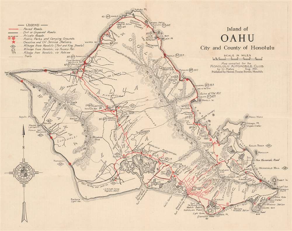
1921 Matsu Road Map of Oahu, Hawaii.
sold
- Digital Map Information
- Suitable for large format printing
- File Size: 10.03 MB
- File Type: ZIP / TIFF
- ICC color profile embedded
- Delivered instantly via download link
This is a 1921 U. Matsu map of the island of Oahu in the Hawaiian Archipelago. The map depicts the entire island in full, from Kaena Point to Makapuu Point and from Kahuku Point to Diamond Head. (more details)
A German colony in Texas.
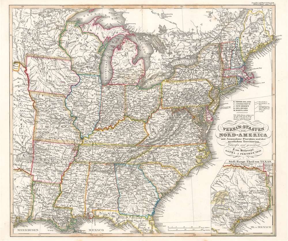
Verein-Staaten von Nord-America mit Ausnahme Florida's und der westlichen Territorien.
sold
- Digital Map Information
- Suitable for large format printing
- Full resolution TIFF file
- ICC color profile embedded
- Delivered instantly via download link
This is a beautifully engraved 1851 Johann Friedrich von Stülpnagel map of the eastern United States. The map depicts from Galveston Bay to the Atlantic Ocean and from Lake Superior to the Gulf of Mexico. Roads, canals, and railroads highlight the nation's transportation network. An inset in the lower right corner details and Texas as it appeared during the Mexican-American War. Cities, towns, and rivers appear here as well. (more details)
Detailed map of southern Luzon during the Philippine-American War.

Southern Luzon. Showing Portion of Theatre of Operations. 8th Army Corps, Major General Elwell S. Otis, Commanding.
sold
- Digital Map Information
- Suitable for large format printing
- File Size: 23.92 MB
- File Type: ZIP / TIFF
- ICC color profile embedded
- Delivered instantly via download link
This is an extremely rare map of Southern Luzon, the Philippines, issued at the height of the Philippine-American War (1899 - 1902) by the Military Governor in the Philippines, Major General Elwell Stephen Otis and the 8th Army Engineering Corps. This map is one of the largest and most detailed cartographic productions to emerge from the Philippine-American War. It depicts southern Luzon, from Alabat Island and Camarines Norte to Albay and the San Bernardino Strait. Identifying roadways, towns and cities, political boundaries, telegraph lines, rivers, and more, this map provides the viewer with a comprehensive view of the situation in the region and it appears to have been based upon Spanish sources, as some of the place names are in Spanish. (more details)
Silver Springs - the largest tourist attractions in Florida in the 1950s.
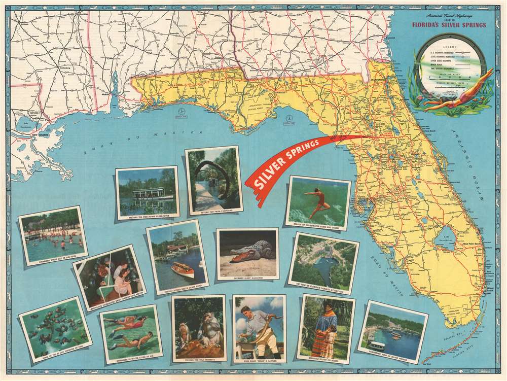
America's Finest Highways Lead to Florida's Silver Springs.
sold
- Digital Map Information
- Suitable for large format printing
- Full resolution TIFF file
- ICC color profile embedded
- Delivered instantly via download link
This is a 1952 Hagstrom map of Florida. Created as a promotional piece for Silver Springs, a tourist attraction outside Ocala, Florida, a large red 'arrow' emphasizes Silver Springs' location in central Florida. U.S. highways are illustrated in red and four highways pass through Ocala, highlighting how easy it would be for travelers to stop at Silver Springs on their way to their final destination or on their way home. Gorgeous color photographs increase Silver Springs' appeal and promote its crystal-clear water, glass-bottom boats, reptile house, and its rhesus macaques. Throughout the 1930s and 1940s, billboards and other advertisements appeared along highways around the country proclaiming the wonders found at Silver Springs, pointing the way, and telling motorists just how far it was from where they were to this paradise. By the 1950s, Silver Springs was the largest tourist attraction in Florida. Today, the 'attraction' is now part of Silver Springs State Park, but the glass-bottom boats (and the slightly dangerous monkeys) still beckon thousands of visitors every year. A wonderful pictorial border, consisting of illustrations of fish, a woman swimming, and a glass-bottom boat, surrounds the entire map. Five maps on the verso detail the highway connections between locations throughout the United States and Silver Springs. (more details)
The first specific map of Vietnam!

Carte du Royaume d'Annam, comprenant les Royaumes du Tumkin et de la Cocinchine.
sold
- Digital Map Information
- Suitable for large format printing
- DPI: 600
- File Size: 10.55 MB
- File Type: ZIP / TIFF
- ICC color profile embedded
- Delivered instantly via download link
An extraordinary rarity, this is the Alexander de Rhodes and Pierre Mariette 1653 map of Vietnam. This is considered the first specific map of the Kingdom of Annam, or Tonkin, what would later become North Vietnam. Coverage extends from roughly Quảng Ngãi, north to the Chinese border, and west as far as Laos and Cambodia. This map represents a major milestone in the mapping of Vietnam and would prove the underpinning cartography of this region through the mid-19th century. (more details)
Unusual woodblock map of Korea w/history.

[Eight Counties of Korea] / 朝鮮八道之圖
sold
- Digital Map Information
- Suitable for large format printing
- Full resolution TIFF file
- ICC color profile embedded
- Delivered instantly via download link
This is a rare Tamiya Kitsuan / Hayashi Shihei xylographic or woodblock map of Korea, with accompanying tables, and a history of Korea, dating to 1806. The map is a stand-alone piece, divorced from Shihei's earlier work, and covers all of Korea as well as the adjacent islands, including the disputed Dokdo and a vastly oversized Ulleungdo. Jeju is not present. Cartographically the map is derived from the work Hayashi Shihei (林子平), but has here been revised with additional historical information on Korea and tables comparing Korea, China, and Japan, compiled by Tamiya Kitsuan (田宮橘菴). (more details)
Possibly the most beautiful map and view of Central Park ever published.

Central Park, New York, A picturesque Guide through the whole Park showing all the improvements up to June 1865.
sold
- Digital Map Information
- Suitable for large format printing
- File Size: 28.74 MB
- File Type: ZIP / TIFF
- ICC color profile embedded
- Delivered instantly via download link
An altogether extraordinary birds-eye view map of New York City's Central Park prepared and printed in 1865 by the famous Boston lithographer Louis Prang. Graced with Prang's exceptional engraving and fine lithography, this is undoubtedly the most beautiful map of Central Park issued in the 19th century. Covering the entire park, Prang's meticulously detailed map illustrates pathways, bridges, lakes, and buildings, along with some individual trees and rocks. All are pictorially rendered in profile. Many of the streets and avenues surrounding the park are also noted. The Park's famous wall, only partially constructed in 1865, is here shown in its completed glory. (more details)