
Europe (whole) (sold)
The updated world and continents maps from the dominant geographical source for its day.
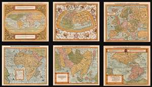
Die erst General Tafel... Ptolemeisch General Tafel... Europa... Asia... Africa... Die newen Inseln.
sold
- Digital Map Information
- Suitable for large format printing
- DPI: 600
- File Size: 76.61 MB
- File Type: ZIP / TIFF
- ICC color profile embedded
- Delivered instantly via download link
This is a beautiful, 6-map set of maps of the world and continents executed for 1588 and later editions of Sebastian Münster's magnum opus, Cosmographia Universalis, entitled in these later editions Cosmographey: das ist, Beschreibung Aller Länder, Herrschafften vnd fürnemesten Stetten des gantzen Erdbodens, sampt ihren Gelegenheiten, Eygenschafften, Religion, Gebräuchen, Geschichten vnd Handtierungen, [et]c. Beginning in 1544, this work would be the primary source of information for anyone who wished to know about the rest of the world: consequently its maps would have had a disproportionate impact, providing the first glimpse of remote and newly-discovered parts World to literate laypeople in Europe for more than half a century. (more details)
Here-to-fore unknown Persian variants of Serio-Comic maps by Fredric Rose and K. I. Kordig. Maps illustrate conflicting perspectives on Russian expansionism and the Balkan Crises.
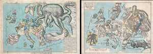
Serio-Comic Map of Europe. / Russian map of Europe.
sold
- Digital Map Information
- Suitable for large format printing
- File Size: 25.5 MB
- File Type: ZIP / TIFF
- ICC color profile embedded
- Delivered instantly via download link
An extraordinary discovery, this is a here-to-fore unknown set of Persian Serio-Comic maps issued around 1880 in Iran. These Serio-Comic maps presuppose that the reader will recognize the familiar shape of Europe and its constituent nations, which have here been ... (more details)
A rare limited edition serio comic map of Europe just after the outbreak of World War II.
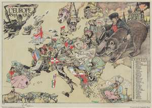
L'Europe en Sept. 1939.
sold
- Digital Map Information
- Suitable for large format printing
- Full resolution TIFF file
- ICC color profile embedded
- Delivered instantly via download link
This is a striking 1939 André Vlaanderen serio-comic map of 'Europe in September 1939' just after the outbreak of World War II - hand colored and signed by the author in a limited release of 150 (this is no. 10). Vlaanderen adopts the serio-comic map genre to convey the violence, chaos, and fear then enveloping Europe. He pays tribute to Fred Rose, the popularizer of the serio-comic map, by drawing Norway and Sweden (Nos. 13 and 14) as dogs, following Rose's 1899 Angling in Troubled Waters. Instead of providing our own explication of this map, we offer Vlaanderen's words in translation from a French version of the accompanying typewritten Dutch text. (more details)
The only known example of Japan's second Serio-Comic map.
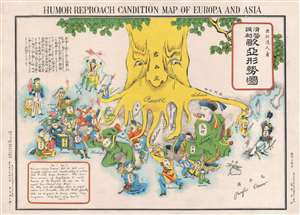
Humor Reproach Candition Map of Europa and Asia. / 滑稽諷刺歐亞形勢圖
sold
- Digital Map Information
- Suitable for large format printing
- File Size: 6.6 MB
- File Type: ZIP / TIFF
- ICC color profile embedded
- Delivered instantly via download link
A previously unknown Meiji 37 or 1904 Japanese broadsheet serio-comic map relating to the Russo-Japanese War. This map was issued in May 28 of 1904, immediately following Japan's successful siege and bombardment Russian held Port Arthur (Dalian). Of the four Japanese serio-comic maps associated with the Russo-Japanese war, this is the second, predated only by Kisaburō Ohara's April 1904 A Humorous Diplomatic Atlas of Europe and Asia. (more details)
The only known example of Japan's second Serio-Comic map.
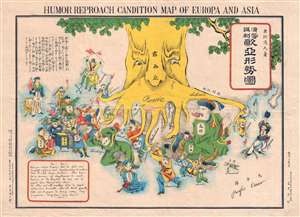
Humor Reproach Candition Map of Europa and Asia. / 滑稽諷刺歐亞形勢圖
sold
- Digital Map Information
- Suitable for large format printing
- File Size: 7.78 MB
- File Type: ZIP / TIFF
- ICC color profile embedded
- Delivered instantly via download link
A previously unknown Meiji 37 or 1904 Japanese broadsheet serio-comic map relating to the Russo-Japanese War. This map was issued in May 28 of 1904, immediately following Japan's successful siege and bombardment Russian held Port Arthur (Dalian). Of the four Japanese serio-comic maps associated with the Russo-Japanese war, this is the second, predated only by Kisaburō Ohara's April 1904 A Humorous Diplomatic Atlas of Europe and Asia. (more details)
Extraordinary manuscript satirical map of Europe during World War II with Chinese Text.
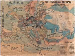
Mapa Humoristico Da Europa - Guerra - 1939 / 歐戰现像
sold
- Digital Map Information
- Suitable for large format printing
- File Size: 8.5 MB
- File Type: ZIP / TIFF
- ICC color profile embedded
- Delivered instantly via download link
An exceptional zoomorphic satirical map of Europe in 1939, here in manuscript form with all text translated into Chinese. This map is based upon a map drawn by the artist António Soares and published by Livraria Franco just weeks after the October 1939 outbreak ... (more details)
Published in only one edition.
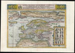
Nova Totius Europae Tabula.
sold
- Digital Map Information
- Suitable for large format printing
- Full resolution TIFF file
- ICC color profile embedded
- Delivered instantly via download link
This is Cornelis De Jode's rare map of Europe, printed in a single edition of 1593. It was among the updated maps added to the De Jode atlas specifically to compete with Ortelius' powerhouse Theatrum Orbis Terrarum. To this end, it combined cartographic information from the most current sources with a level of decorative flourish that had not yet appeared in any atlas. It also presented its subject with a broader focus to incorporate newer information about the northern parts of the world not present on the elder De Jode's map. (more details)
One of only 2 Japanese serio-comic maps illustrating World War I.
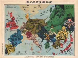
Kokkei Sensou Sekai Chizu. / Ahumoros Wap Map of the World. / 滑馨戰争世界地圖
sold
- Digital Map Information
- Suitable for large format printing
- File Size: 17.14 MB
- File Type: ZIP / TIFF
- ICC color profile embedded
- Delivered instantly via download link
A very rare Japanese broadsheet serio-comic map of Europe and Asia drawn just following the outbreak of World War I. This map was drawn by Ryōzō Tanaka and published by the Shobido Company of Tokyo. The map covers all of Europe and parts of East Asia. All ... (more details)
Spectacular pictorial world map illustrating Post-WII situation in Europe and America.
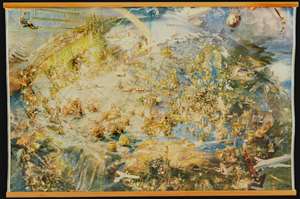
[Oliver Neerlands Bildkarta]
sold
- Digital Map Information
- Suitable for large format printing
- Full resolution TIFF file
- ICC color profile embedded
- Delivered instantly via download link
This is an utterly stunning 1949 pictorial color lithograph wall map of the northern part of the western world by the Norwegian artist Oliver Neerland. The map covers all of North America, the North Atlantic, and Europe as far east as the Caspian Sea, as well as from the North Pole to the Amazon River and Liberia. Lavish illustration depicts historic figures, monuments, art and architecture, animals, airplanes, dirigibles, sailing ships of all types, aircraft characters, and more. (more details)
Extremely rare Japanese perspective satirical 'Octopus Map' of Asia.
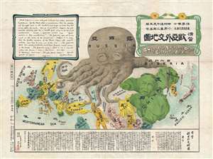
A Humorous Diplomatic Atlas of Europe and Asia. / 滑稽欧亜外交地図 / Kokkei Ō-A Gaikō Chizu.
sold
- Digital Map Information
- Suitable for large format printing
- File Size: 13.3 MB
- File Type: ZIP / TIFF
- ICC color profile embedded
- Delivered instantly via download link
A wonderful example of the rare 1904 Kisaburō Ohara / Shingo Nakamura satirical 'Octopus Map' of Europe. Composed at the outbreak of the Russo-Japanese War (1904 - 1905), Ohara here follows the conventions established by J. J. van Brederode ( Humoristische-Oorlogskaart, 1870) and Fred Rose (Serio-Comic War Map, 1877). These two maps established the convention of satirizing Russian expansionism as a menacing Kraken-like 'Black Octopus.' Whereas Brederode and Rose confine their images to Russia, Ohara has here expanded the idea to encompass all of Eurasia. Russia's eight grasping tentacles extend across Europe and Asia; on many countries they already have a firm grip. Finland, Poland, Crimea, and the Balkan nations are represented as skulls, while tentacles grasp Turkey around the foot and waist, Persia about the neck, and Tibet by the arm. The Trans-Siberian Railway and the South Manchuria Railway, represented by the rightmost tentacle, had by this time extended Russian influence into Manchuria as far as the valuable ice-free Russian stronghold of Port Arthur. As this map was issued in March of 1904, the struggle between Russian and Japan over control of Port Arthur was ongoing. Port Arthur was surrendered to the Japanese, who defeated the Russian Fleet in December of 1905, several months after this map was printed. Ohara sums up the situation in his English language descriptions of the map, printed in the upper left,
Black Octopus is a name newly given to Russia by a certain prominent Englishman. For the black octopus is so avaricious, that he stretches out his eight arms in all directions, and seizes up every thing that comes within his reach. But as it sometimes happens he gets wounded seriously even by a small fish, owing to his too much covetousness. Indeed, a Japanese proverb says: 'Great avarice is like unselfishness.' We Japanese need not to say much on the cause of the present war. Suffice it to say that the further existence of the Black Octopus will depend entirely upon how he comes out of this war. The Japanese fleet has already practically annihilated Russia's naval powers in the Orient. The Japanese army is about to win a signal victory over Russia in Corea and Manchuria. And when ... St. Petersburg? Wait and see! The ugly Black Octopus! Hurrah! Hurrah! for Japan.Certainly the map had a strong message, but who saw it? (more details)
Extremely rare Japanese perspective satirical 'Octopus Map' of Asia.
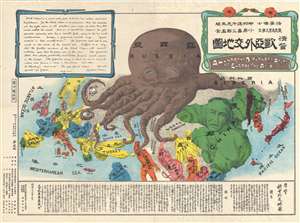
A Humorous Diplomatic Atlas of Europe and Asia. / 滑稽欧亜外交地図 / Kokkei Ō-A Gaikō Chizu.
sold
- Digital Map Information
- Suitable for large format printing
- File Size: 13.69 MB
- File Type: ZIP / TIFF
- ICC color profile embedded
- Delivered instantly via download link
A wonderful example of the rare 1904 Kisaburō Ohara / Shingo Nakamura satirical 'Octopus Map' of Europe. Composed at the outbreak of the Russo-Japanese War (1904 - 1905), Ohara here follows the conventions established by J. J. van Brederode ( Humoristische-Oorlogskaart, 1870) and Fred Rose (Serio-Comic War Map, 1877). These two maps established the convention of satirizing Russian expansionism as a menacing Kraken-like 'Black Octopus.' Whereas Brederode and Rose confine their images to Russia, Ohara has here expanded the idea to encompass all of Eurasia. Russia's eight grasping tentacles extend across Europe and Asia; on many countries they already have a firm grip. Finland, Poland, Crimea, and the Balkan nations are represented as skulls, while tentacles grasp Turkey around the foot and waist, Persia about the neck, and Tibet by the arm. The Trans-Siberian Railway and the South Manchuria Railway, represented by the rightmost tentacle, had by this time extended Russian influence into Manchuria as far as the valuable ice-free Russian stronghold of Port Arthur. As this map was issued in March of 1904, the struggle between Russian and Japan over control of Port Arthur was ongoing. Port Arthur was surrendered to the Japanese, who defeated the Russian Fleet in December of 1905, several months after this map was printed. Ohara sums up the situation in his English language descriptions of the map, printed in the upper left,
Black Octopus is a name newly given to Russia by a certain prominent Englishman. For the black octopus is so avaricious, that he stretches out his eight arms in all directions, and seizes up every thing that comes within his reach. But as it sometimes happens he gets wounded seriously even by a small fish, owing to his too much covetousness. Indeed, a Japanese proverb says: 'Great avarice is like unselfishness.' We Japanese need not to say much on the cause of the present war. Suffice it to say that the further existence of the Black Octopus will depend entirely upon how he comes out of this war. The Japanese fleet has already practically annihilated Russia's naval powers in the Orient. The Japanese army is about to win a signal victory over Russia in Corea and Manchuria. And when ... St. Petersburg? Wait and see! The ugly Black Octopus! Hurrah! Hurrah! for Japan.Certainly the map had a strong message, but who saw it? (more details)
Extremely rare Japanese perspective satirical 'Octopus Map' of Asia.
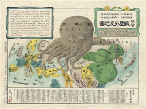
A Humorous Diplomatic Atlas of Europe and Asia. / 滑稽欧亜外交地図 / Kokkei Ō-A Gaikō Chizu.
sold
- Digital Map Information
- Suitable for large format printing
- File Size: 13 MB
- File Type: ZIP / TIFF
- ICC color profile embedded
- Delivered instantly via download link
A wonderful example of the rare 1904 Kisaburō Ohara / Shingo Nakamura satirical 'Octopus Map' of Europe. Composed at the outbreak of the Russo-Japanese War (1904 - 1905), Ohara here follows the conventions established by J. J. van Brederode ( Humoristische-Oorlogskaart, 1870) and Fred Rose (Serio-Comic War Map, 1877). These two maps established the convention of satirizing Russian expansionism as a menacing Kraken-like 'Black Octopus.' Whereas Brederode and Rose confine their images to Russia, Ohara has here expanded the idea to encompass all of Eurasia. Russia's eight grasping tentacles extend across Europe and Asia; on many countries they already have a firm grip. Finland, Poland, Crimea, and the Balkan nations are represented as skulls, while tentacles grasp Turkey around the foot and waist, Persia about the neck, and Tibet by the arm. The Trans-Siberian Railway and the South Manchuria Railway, represented by the rightmost tentacle, had by this time extended Russian influence into Manchuria as far as the valuable ice-free Russian stronghold of Port Arthur. As this map was issued in March of 1904, the struggle between Russian and Japan over control of Port Arthur was ongoing. Port Arthur was surrendered to the Japanese, who defeated the Russian Fleet in December of 1905, several months after this map was printed. Ohara sums up the situation in his English language descriptions of the map, printed in the upper left,
Black Octopus is a name newly given to Russia by a certain prominent Englishman. For the black octopus is so avaricious, that he stretches out his eight arms in all directions, and seizes up every thing that comes within his reach. But as it sometimes happens he gets wounded seriously even by a small fish, owing to his too much covetousness. Indeed, a Japanese proverb says: 'Great avarice is like unselfishness.' We Japanese need not to say much on the cause of the present war. Suffice it to say that the further existence of the Black Octopus will depend entirely upon how he comes out of this war. The Japanese fleet has already practically annihilated Russia's naval powers in the Orient. The Japanese army is about to win a signal victory over Russia in Corea and Manchuria. And when ... St. Petersburg? Wait and see! The ugly Black Octopus! Hurrah! Hurrah! for Japan.Certainly the map had a strong message, but who saw it? (more details)
Extremely rare Japanese perspective satirical 'Octopus Map' of Asia.
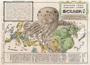
A Humorous Diplomatic Atlas of Europe and Asia. / 滑稽欧亜外交地図 / Kokkei Ō-A Gaikō Chizu.
sold
- Digital Map Information
- Suitable for large format printing
- File Size: 15.14 MB
- File Type: ZIP / TIFF
- ICC color profile embedded
- Delivered instantly via download link
A wonderful example of the rare 1904 Kisaburō Ohara / Shingo Nakamura satirical 'Octopus Map' of Europe. Composed at the outbreak of the Russo-Japanese War (1904 - 1905), Ohara here follows the conventions established by J. J. van Brederode ( Humoristische-Oorlogskaart, 1870) and Fred Rose (Serio-Comic War Map, 1877). These two maps established the convention of satirizing Russian expansionism as a menacing Kraken-like 'Black Octopus.' Whereas Brederode and Rose confine their images to Russia, Ohara has here expanded the idea to encompass all of Eurasia. Russia's eight grasping tentacles extend across Europe and Asia; on many countries they already have a firm grip. Finland, Poland, Crimea, and the Balkan nations are represented as skulls, while tentacles grasp Turkey around the foot and waist, Persia about the neck, and Tibet by the arm. The Trans-Siberian Railway and the South Manchuria Railway, represented by the rightmost tentacle, had by this time extended Russian influence into Manchuria as far as the valuable ice-free Russian stronghold of Port Arthur. As this map was issued in March of 1904, the struggle between Russian and Japan over control of Port Arthur was ongoing. Port Arthur was surrendered to the Japanese, who defeated the Russian Fleet in December of 1905, several months after this map was printed. Ohara sums up the situation in his English language descriptions of the map, printed in the upper left,
Black Octopus is a name newly given to Russia by a certain prominent Englishman. For the black octopus is so avaricious, that he stretches out his eight arms in all directions, and seizes up every thing that comes within his reach. But as it sometimes happens he gets wounded seriously even by a small fish, owing to his too much covetousness. Indeed, a Japanese proverb says: 'Great avarice is like unselfishness.' We Japanese need not to say much on the cause of the present war. Suffice it to say that the further existence of the Black Octopus will depend entirely upon how he comes out of this war. The Japanese fleet has already practically annihilated Russia's naval powers in the Orient. The Japanese army is about to win a signal victory over Russia in Corea and Manchuria. And when ... St. Petersburg? Wait and see! The ugly Black Octopus! Hurrah! Hurrah! for Japan.Certainly the map had a strong message, but who saw it? (more details)
Serio comic map of Europe just after the outbreak of World War II.
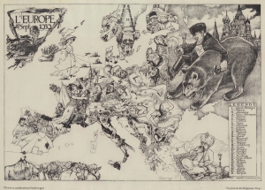
L'Europe en Sept. 1939.
sold
- Digital Map Information
- Suitable for large format printing
- File Size: 57.07 MB
- File Type: ZIP / TIFF
- ICC color profile embedded
- Delivered instantly via download link
This is a striking 1939 André Vlaanderen serio-comic map of 'Europe in September 1939' just after the outbreak of World War II. Vlaanderen adopts the serio-comic map genre to convey the violence, chaos, and fear that enveloped Europe. He pays tribute to Fred Rose, the popularizer of the serio-comic map, by drawing Norway and Sweden (Nos. 13 and 14) as dogs, following Rose's 1899 Angling in Troubled Waters. Instead of providing our own explication of this map, we offer Vlaanderen's words instead. (more details)
Magnificent 18th century wall map of Europe.
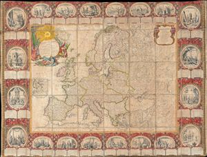
Carte D'Eurpe Divisee En ses Empires et Royaumes.
sold
- Digital Map Information
- Suitable for large format printing
- DPI: 300
- File Size: 77.43 MB
- File Type: ZIP / TIFF
- ICC color profile embedded
- Delivered instantly via download link
A large and impressively decorative 1776 case map or pocket map of europe by Jean Baptiste Louis Clouet. Clouet's map covers all of europe from Spain to the Ural Mountains and from Nova Zembla and the Arctic Ocean to North Africa, Turkey, and Persia. It ... (more details)
Extremely rare Japanese perspective satirical 'Octopus Map' of Asia.
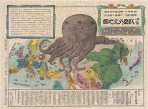
A Humorous Diplomatic Atlas of Europe and Asia. / 滑稽欧亜外交地図 / Kokkei Ō-A Gaikō Chizu.
sold
- Digital Map Information
- Suitable for large format printing
- File Size: 12.9 MB
- File Type: ZIP / TIFF
- ICC color profile embedded
- Delivered instantly via download link
A wonderful example of the rare 1904 Kisaburō Ohara / Shingo Nakamura satirical 'Octopus Map' of Europe. Composed at the outbreak of the Russo-Japanese War (1904 - 1905), Ohara here follows the conventions established by J. J. van Brederode ( Humoristische-Oorlogskaart, 1870) and Fred Rose (Serio-Comic War Map, 1877). These two maps established the convention of satirizing Russian expansionism as a menacing Kraken-like 'Black Octopus.' Whereas Brederode and Rose confine their images to Russia, Ohara has here expanded the idea to encompass all of Eurasia. Russia's eight grasping tentacles extend across Europe and Asia; on many countries they already have a firm grip. Finland, Poland, Crimea, and the Balkan nations are represented as skulls, while tentacles grasp Turkey around the foot and waist, Persia about the neck, and Tibet by the arm. The Trans-Siberian Railway and the South Manchuria Railway, represented by the rightmost tentacle, had by this time extended Russian influence into Manchuria as far as the valuable ice-free Russian stronghold of Port Arthur. As this map was issued in March of 1904, the struggle between Russian and Japan over control of Port Arthur was ongoing. Port Arthur was surrendered to the Japanese, who defeated the Russian Fleet in December of 1905, several months after this map was printed. Ohara sums up the situation in his English language descriptions of the map, printed in the upper left,
Black Octopus is a name newly given to Russia by a certain prominent Englishman. For the black octopus is so avaricious, that he stretches out his eight arms in all directions, and seizes up every thing that comes within his reach. But as it sometimes happens he gets wounded seriously even by a small fish, owing to his too much covetousness. Indeed, a Japanese proverb says: 'Great avarice is like unselfishness.' We Japanese need not to say much on the cause of the present war. Suffice it to say that the further existence of the Black Octopus will depend entirely upon how he comes out of this war. The Japanese fleet has already practically annihilated Russia's naval powers in the Orient. The Japanese army is about to win a signal victory over Russia in Corea and Manchuria. And when ... St. Petersburg? Wait and see! The ugly Black Octopus! Hurrah! Hurrah! for Japan.Certainly the map had a strong message, but who saw it? (more details)
Most beautifully executed woodcut map of Europe.
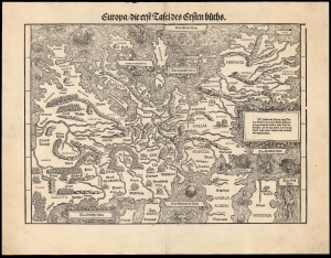
Europa die erst Tafel des Ersten Buchs.
sold
- Digital Map Information
- Suitable for large format printing
- DPI: 600
- File Size: 36.82 MB
- File Type: ZIP / TIFF
- ICC color profile embedded
- Delivered instantly via download link
This is a rare, 1548 example of Johann Stumpf's southern oriented map of Europe. It is the only map derived from Sebastian Münster's map of the continent, and thus is the last derivative of Martin Waldseemüller's unobtainable 1511 map of Europe. While Münster's map went to many editions and is readily acquirable, Stumpf's work was produced in significantly smaller numbers and consequently is a much rarer work. It is moreover larger and more beautifully executed, and is consequently more desirable. (more details)
One-of-a-kind Ottoman Serio-Comic WWI Propaganda Map.
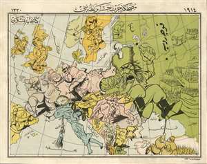
A Háborús Európa Térkép-Karikatúrája. / [A Cartoon War Map of Europe].
sold
- Digital Map Information
- Suitable for large format printing
- File Size: 16.22 MB
- File Type: ZIP / TIFF
- ICC color profile embedded
- Delivered instantly via download link
The only known example of the Ottoman Turkish edition of Varga Imre's important 1914 serio-propaganda map of Europe at the outset of World War I (1814 - 1918), A Háborús Európa Térkép-Karikatúrája. The map is essentially propaganda for the Central Powers wherein Russia appears as an obnoxious drunk and Hungary is illustrated charging fiercely into battle - note, this is the only WWI Era serio-comic map to illustrate Hungary independently. In this Ottoman edition, released in Istanbul by Khaireya and Co. Press, all the text has been translated into Ottoman Turkish. (more details)
Extraordinary 'Iron Curtain' Cold War serio-comic map! One of only 2 Serio-Comic maps to illustrate the Iron Curtain.
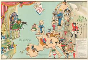
Mapa Humoristico da Europa em 1953
sold
- Digital Map Information
- Suitable for large format printing
- File Size: 34.8 MB
- File Type: ZIP / TIFF
- ICC color profile embedded
- Delivered instantly via download link
An exceptional and rare 1953 J. R. Silva serio-comic zoomorphic pictorial map of Europe illustrating the raising of the Iron Curtain at the height of the Cold War. The map covers Europe and parts of the Atlantic, and is one of only 2 serio-comic maps to illustrate the Iron Curtain. It presents the political situation in 1953, shortly after the death of Joseph Stalin, the rise of Nikita Krushchev, and Georgi Malenkov's announcement of the Soviet Union's first hydrogen bomb. Silva is playing on the traditional meaning of 'Iron Curtain' as a fireproof barrier in theaters. He further interprets the chaos of post-Stalin European politics as a 'circus.'
In this serio-comic map, a great wrought iron fence, the Iron Curtain, divides Europe. Russia, a great polar bear, is the antagonist, with subject nations, lesser bears, dancing and performing to its tune. Other European countries look on with fear, boredom, and curiosity while the Americas, on a large balcony across the Atlantic, show great interest in the show. The dominant North American powers are represented by a Mexican horse / cowboy, a Canadian walrus / sailor, and a militaristic United States lion. Other American nations, comprising Central and South America, appear as a great variety of well-dressed birds, all of which are labeled. (more details)
In this serio-comic map, a great wrought iron fence, the Iron Curtain, divides Europe. Russia, a great polar bear, is the antagonist, with subject nations, lesser bears, dancing and performing to its tune. Other European countries look on with fear, boredom, and curiosity while the Americas, on a large balcony across the Atlantic, show great interest in the show. The dominant North American powers are represented by a Mexican horse / cowboy, a Canadian walrus / sailor, and a militaristic United States lion. Other American nations, comprising Central and South America, appear as a great variety of well-dressed birds, all of which are labeled. (more details)
Rare Persian langauge variant of the Fred Rose 'Octopus Map' of Euopre. One of only 2 known examples.
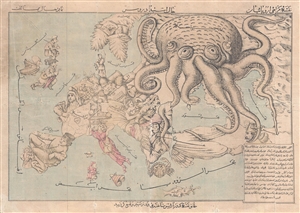
Comic Map of Europe. / نقشه طنز از اروپا
sold
- Digital Map Information
- Suitable for large format printing
- File Size: 10.45 MB
- File Type: ZIP / TIFF
- ICC color profile embedded
- Delivered instantly via download link
A very rare c. 1880 Persian version of Englishman Fred Rose's iconic 1877 Serio Comic War Map , in which expansionist Imperial Russia is analogized as a menacing grasping octopus. Iranians at this time were beset by incursions from both Western Europe, ... (more details)
One of Fred Rose's most iconic Serio-Comic caricature maps.
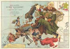
Angling in Troubled Waters A Serio-Comic Map of Europe by Fred. W. Rose Author of the 'Octopus Map of Europe'
sold
- Digital Map Information
- Suitable for large format printing
- File Size: 21.89 MB
- File Type: ZIP / TIFF
- ICC color profile embedded
- Delivered instantly via download link
One of Frederick W. Rose's most iconic caricature or satirical maps, this is the 1899 Angling in Troubled Waters . The map presupposes that the reader will recognize the familiar shape of Europe and its constituent nations, which have here been ... (more details)
Monumental and rare World War II route map.
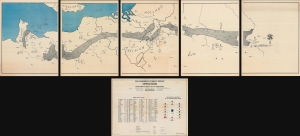
Operations from Omaha Beach to Elbe River.
sold
- Digital Map Information
- Suitable for large format printing
- Full resolution TIFF file
- ICC color profile embedded
- Delivered instantly via download link
This is a monumental and impressive 1945 John A. LeDonne route map of Europe tracing the movements of the 1115th Engineer Combat Group during World War II. It is the largest and most impressive 'Route Map' to emerge out of World War II (1939 - 1945). (more details)
Monumental and rare World War II route map.
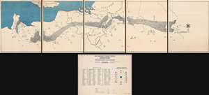
Operations from Omaha Beach to Elbe River.
sold
- Digital Map Information
- Suitable for large format printing
- Full resolution TIFF file
- ICC color profile embedded
- Delivered instantly via download link
This is a monumental and impressive 1945 John A. LeDonne route map of Europe tracing the movements of the 1115th Engineer Combat Group during World War II. It is the largest and most impressive 'Route Map' to emerge out of World War II (1939 - 1945). (more details)
Continent in Crisis.
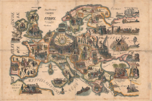
Politische Chart von Europa.
sold
- Digital Map Information
- Suitable for large format printing
- File Size: 17.09 MB
- File Type: ZIP / TIFF
- ICC color profile embedded
- Delivered instantly via download link
This is Franz Werner's rare 1848 pictorial satirical map of Europe, depicting the Springtime of Nations, also known as the Revolutions of 1848, that rocked the continent that year. The map promotes the revolutionary idea of a 'Vereinigten Staaten des Freien Deutschlands' [United States of Free Germany], advocating for a U.S.-style democratic system. The failure of the revolutions led to the emigration of thousands of well-educated but disillusioned middle-class European tradespeople to the United States, which in turn spurred a flowering of American industry and publishing. (more details)
Earliest map of Europe based on contemporaneous knowledge.
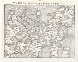
Tabula Nova Prima Europa.
sold
- Digital Map Information
- Suitable for large format printing
- Full resolution TIFF file
- ICC color profile embedded
- Delivered instantly via download link
This is a rare 1545 example of Sebastian Münster's southern-oriented map of Europe: an early imprint of the first acquirable map of Europe based on contemporary geographical information, and the only generally acquirable derivative of Martin Waldseemüller's unobtainable 1511 map of Europe. Münster's Geographia and Cosmographia provided for many years the literate European's only glimpses of the world, and these two works contained a number of maps with previously unseen contemporaneous knowledge of the areas they depicted. For Münster's readership, this map was almost certainly the first depiction of their home continent not based upon the 2nd century work of Claudius Ptolemy. (more details)
An allegorical glance at the start of World War I.
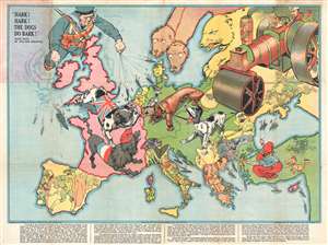
Hark! Hark! The Dogs Do Bark!
sold
- Digital Map Information
- Suitable for large format printing
- File Size: 15.87 MB
- File Type: ZIP / TIFF
- ICC color profile embedded
- Delivered instantly via download link
An iconic serio-comic map by Johnson, Riddle, and Company issued shortly after the outbreak of World War I. The map covers all of Europe from the Atlantic to the Black Sea and from Scandinavia to Italy. Superimposed on the map are a host of ... (more details)
British propaganda celebrating 'victory' in the Battle of the Atlantic.
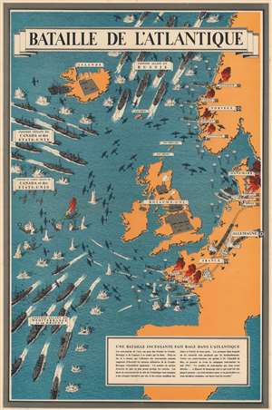
Bataille de l'Atlantique.
sold
- Digital Map Information
- Suitable for large format printing
- File Size: 84.51 MB
- File Type: ZIP / TIFF
- ICC color profile embedded
- Delivered instantly via download link
This is a 1943 Frederick Donald Blake pictorial propaganda broadside of the Battle of the Atlantic - one of the longest and bloodiest campaigns of World War II (1939 - 1945). (more details)
Frederic Rose's most sophisticed 'Octopus Map'.
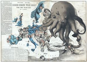
Revised Edition Serio-Comic War Map for the Year 1877.
sold
- Digital Map Information
- Suitable for large format printing
- File Size: 16.11 MB
- File Type: ZIP / TIFF
- ICC color profile embedded
- Delivered instantly via download link
Commonly known as the 'Octopus Map,' this is a remarkable 1877 caricature map of Europe by Frederic Rose. The map presupposes that the reader will recognize the familiar shape of Europe and its constituent nations, which have here been ... (more details)
Everyone's favorite map monster.
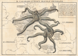
Il Calamaro O' 'Pesce Diavolo' Prussiano.
sold
- Digital Map Information
- Suitable for large format printing
- File Size: 12.01 MB
- File Type: ZIP / TIFF
- ICC color profile embedded
- Delivered instantly via download link
This is a scarce 1916 British propaganda map of Europe with Prussia and Austria-Hungary depicted as voracious octopuses. This Italian-language example was issued to persuade a divided Italian public to ally with the Entente against the Central Powers (Germany and Austria-Hungary). (more details)
'The Dogs of War are loose in Europe!' - Emanuel
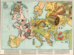
Hark! Hark! The Dogs Do Bark!
sold
- Digital Map Information
- Suitable for large format printing
- File Size: 35.06 MB
- File Type: ZIP / TIFF
- ICC color profile embedded
- Delivered instantly via download link
An iconic 1914 serio-comic satirical map by Johnson, Riddle, and Company issued shortly after the outbreak of World War I (1914 - 1918). The map covers Europe from the Atlantic to the Black Sea and from Scandinavia to Italy. Superimposed on the map are a host of dogs, as well as other animals, and several human figures. Text by the popular Jewish satirist Walter Lewis Emanual appears at the bottom. The lighthearted content captures English optimism early in the war. It was widely assumed that British naval superiority would end the war quickly, some argued in as little as six weeks. (more details)
Depicts the Gulf Stream - a current along the coast of North America that effects the climate in the eastern United States and Europe.
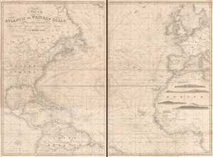
A Chart of the Atlantic or Western Ocean.
sold
- Digital Map Information
- Suitable for large format printing
- File Size: 42.08 MB
- File Type: ZIP / TIFF
- ICC color profile embedded
- Delivered instantly via download link
This is an exquisitely composed 1855 John Stratton Hobbs nautical chart or maritime map of the Atlantic Ocean. The map, comprising two sheets, depicts the region from central North America and the Galápagos Islands to Sweden, the ... (more details)
Earliest map of Europe based on contemporaneous knowledge.
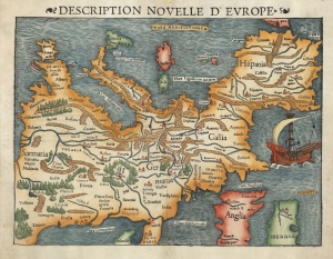
Description Nouvelle D'Europe.
sold
- Digital Map Information
- Suitable for large format printing
- Full resolution TIFF file
- ICC color profile embedded
- Delivered instantly via download link
This is a 1552 example of Sebastian Münster's southern-oriented map of Europe: the first acquirable map of Europe based on contemporary geographical information, and the only generally acquirable derivative of Martin Waldseemüller's unobtainable 1511 map of Europe. Münster's works provided for many years the literate European's only glimpses of the world, containing a disproportionate number of maps containing, for the first time, contemporaneous knowledge of the areas they depicted. For most of Münster's readership, this map would have been the first depiction of their home continent not based upon the 2nd century work of Claudius Ptolemy. (more details)