
Pictorial Maps (sold)
The largest and most decorative map of Shanghai!
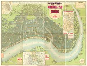
The New Commercial Plan of Shanghai (with which is incorporated the Wharf and Godown Plan). Surveyed, constructed and designed by the Far Eastern Geographical Establishment 6 Kiukiang Road Shanghai.
sold
- Digital Map Information
- Suitable for large format printing
- File Size: 300.62 MB
- File Type: ZIP / TIFF
- ICC color profile embedded
- Delivered instantly via download link
The greatest and most impressive map of Shanghai we have yet seen. Issued in 1915, this is the Far Eastern Geographical Establishment / Edwin John Dingle / H. J. Fruin pictorial view and map of Shanghai. The map is a staggering 83 x 63 inches. The view looks on Shanghai from the east, at a high point across the Huangpu River in what is today the hip Pudong district. In includes the Bund, the Shanghai International Settlement, and the British and French Concessions, as well as the old Chinese City at left. It was issued shortly after the shortly after the 1911 Xinhai Revolution. One can follow Wusong Creek westward into the Horizon, which is illustrated with clouds. Inset maps detail Shanghai and Environs, Road Plan of Shanghai, The Nantao District, and The Rubicon District. (more details)
Gangland Style! The greatest pictorial map of all time! Addressing socially, politically, and legally volitile issues!
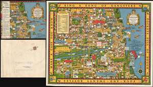
A Map of Chicago's Gangland from Authentic Sources. Designed to Inculcate the Most Important Principles of Piety and Virtue in Young Persons and Graphically Portray the Evils and Sin and Large Cities.
sold
- Digital Map Information
- Suitable for large format printing
- File Size: 52.39 MB
- File Type: ZIP / TIFF
- ICC color profile embedded
- Delivered instantly via download link
Perhaps the greatest pictorial map of all time, this is the legendary 1931 Bruce-Roberts cartoon map of Gangland Chicago, accompanied by its original mailer. Although not drawn to scale, the map covers downtown Chicago from Lincoln Park to Jackson Park and west as far as Cicero and Stickney. When this map was issued, Chicago's Prohibition Era gang wars were winding down. Al Capone, Chicago's criminal king-pin, was convicted of tax evasion and sentenced to 11 years in federal prison in October of this same year. Nonetheless, as this went to press, probably in August or September of 1931, all of Chicago was reeling from years of violent gang warfare. Unlike any previous pictorial map, the revolutionary unknown artist that drew this map is embracing politically, socially, and legally complex issues at the moment of their highest volatility. It comes thus as no surprise that the artist chose to remain anonymous. Despite its violent if cartoonish content, the map was issued with the noble intent, 'to inculcate the most important principles of Piety and virtue in young persons and graphically portray the evils and sin of large cities.' (more details)
Here-to-fore unknown Persian variants of Serio-Comic maps by Fredric Rose and K. I. Kordig. Maps illustrate conflicting perspectives on Russian expansionism and the Balkan Crises.
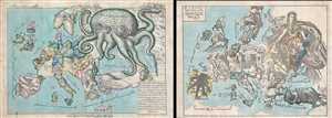
Serio-Comic Map of Europe. / Russian map of Europe.
sold
- Digital Map Information
- Suitable for large format printing
- File Size: 25.5 MB
- File Type: ZIP / TIFF
- ICC color profile embedded
- Delivered instantly via download link
An extraordinary discovery, this is a here-to-fore unknown set of Persian Serio-Comic maps issued around 1880 in Iran. These Serio-Comic maps presuppose that the reader will recognize the familiar shape of Europe and its constituent nations, which have here been ... (more details)
Holy grail of Ge'hog'raphy.
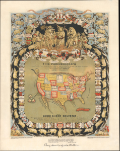
This Porcineograph. / This Good-Cheer Souvenir.
sold
- Digital Map Information
- Suitable for large format printing
- File Size: 49.46 MB
- File Type: ZIP / TIFF
- ICC color profile embedded
- Delivered instantly via download link
The coveted Porcineograph, considered one of the greatest examples of cartographic whimsy ever made! This is a comical 1876 William Emerson Baker chromolithograph pictorial map - geohography - of the United States as a pig. Initially issued as a party favor, the image is not only humorous but also examines the impact of pigs in American history, including their role in the foundation of the Massachusetts Senate and the Declaration of the War of 1812. (more details)
A rare limited edition serio comic map of Europe just after the outbreak of World War II.
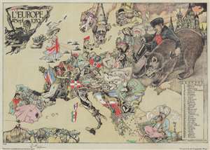
L'Europe en Sept. 1939.
sold
- Digital Map Information
- Suitable for large format printing
- Full resolution TIFF file
- ICC color profile embedded
- Delivered instantly via download link
This is a striking 1939 André Vlaanderen serio-comic map of 'Europe in September 1939' just after the outbreak of World War II - hand colored and signed by the author in a limited release of 150 (this is no. 10). Vlaanderen adopts the serio-comic map genre to convey the violence, chaos, and fear then enveloping Europe. He pays tribute to Fred Rose, the popularizer of the serio-comic map, by drawing Norway and Sweden (Nos. 13 and 14) as dogs, following Rose's 1899 Angling in Troubled Waters. Instead of providing our own explication of this map, we offer Vlaanderen's words in translation from a French version of the accompanying typewritten Dutch text. (more details)
An eccentric millionaire's folly.
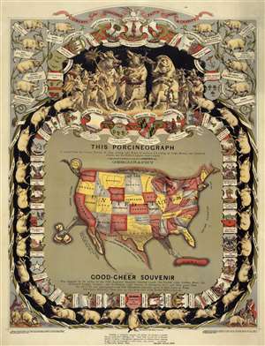
This Porcineograph. / This Good-Cheer Souvenir.
sold
- Digital Map Information
- Suitable for large format printing
- File Size: 7.75 MB
- File Type: ZIP / TIFF
- ICC color profile embedded
- Delivered instantly via download link
The coveted Porcineograph! One of the greatest examples of cartographic whimsy ever made! This is a comical 1876 William Emerson Baker pictorial map of the United States as a pig. With the pig's snout at Maine and its tail in 'Alas-queue', the continental United ... (more details)
Unabashed Japanese ambitions in WWI.
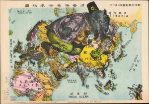
The Illustration of the Graet European War. No. 16. A Humoros Atlas of the World. / 歐洲大戰亂畫報(其十六)滑稽欧亜外交地図.
sold
- Digital Map Information
- Suitable for large format printing
- File Size: 28.45 MB
- File Type: ZIP / TIFF
- ICC color profile embedded
- Delivered instantly via download link
An exceptional September 13, 1914, Japanese serio-comic map of Asia and Europe at the outbreak of World War I. The masterfully drawn chromolithograph map unabashedly illustrates Japanese aspirations to exploit the war in Europe, with underpinning elements of cultural supremacy, imperial ambitions towards China, concern over but contempt for Russia, and grudging respect towards the United States. (more details)
The most magnificent pictorial map of China ever produced.
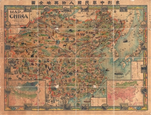
A Map of China. / 象形中華民國人物輿地全圖 / Xiàngxíng Zhōnghuá Mínguó Rénwù Yúdì Quántú (Pictorial Full Map of the People and Geography of the Republic of China.)
sold
- Digital Map Information
- Suitable for large format printing
- File Size: 177.27 MB
- File Type: ZIP / TIFF
- ICC color profile embedded
- Delivered instantly via download link
The most extraordinary pictorial map we have seen to date. A masterpiece, this scarce and enormous lavishly pictorial map of China was compiled in 1931 by John A. Diakoff and drawn by G. Primakoff. The map covers all of China from Kashgar and Yarken to Korea ... (more details)
Amazing early pictorial map promoting the furrier business of Chapal.
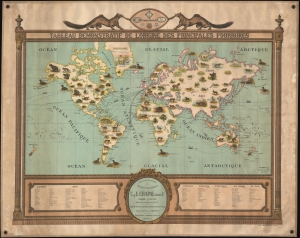
Tableau Demonstratif de L'Origine des Principales Fourrures.
sold
- Digital Map Information
- Suitable for large format printing
- File Size: 65.79 MB
- File Type: ZIP / TIFF
- ICC color profile embedded
- Delivered instantly via download link
A remarkable and rare 1917 pictorial wall map of the world issued to promote the furrier business of C. et E. Chapal. This is one of the earliest modern pictorial maps we have seen, predating the rise of pictorial cartography in the mid-1920s and its golden age in the 1930s-1940s. The map combines informative graphics with playful imagery and persuasive promotional elements. (more details)
The most magnificent pictorial map of China ever produced.
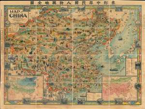
A Map of China. / 象形中華民國人物輿地全圖 / Xiàngxíng Zhōnghuá Mínguó Rénwù Yúdì Quántú (Pictorial Full Map of the People and Geography of the Republic of China.)
sold
- Digital Map Information
- Suitable for large format printing
- Full resolution TIFF file
- ICC color profile embedded
- Delivered instantly via download link
Among the most extraordinary pictorial maps we have seen to date, a masterpiece. This enormous and lavish chromolithograph pictorial map of China was compiled in 1931 by John A. Diakoff, drawn by G. Primakoff, and printed by Yao-Hsiun. The map covers all of China from Kashgar to Taiwan, including neighboring Korea, Japan, Mongolia, and Nepal. All lands within the borders of China are rich in color and detail with countless vignettes illustrating a diversity of plant and animal life, distinct cultures, architectures, and resources. Text and annotations throughout are in both English and Chinese. Regions outside of China, like Japan, Korea, and India, are also heavily illustrated with vignettes, but are not in color. (more details)
Most magnificent pictorial map of China.
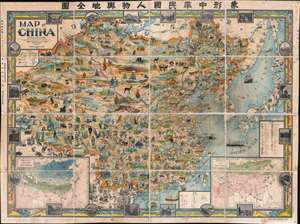
A Map of China. / 象形中華民國人物輿地全圖 / Xiàngxíng Zhōnghuá Mínguó Rénwù Yúdì Quántú (Pictorial Full Map of the People and Geography of the Republic of China.)
sold
- Digital Map Information
- Suitable for large format printing
- Full resolution TIFF file
- ICC color profile embedded
- Delivered instantly via download link
The most extraordinary pictorial map we have seen and the best specifically of China, a masterpiece. This enormous and lavish chromolithograph pictorial map of China was compiled in 1931 by John A. Diakoff, drawn by G. Primakoff, and printed by Yao-Hsiun. The map covers China from Kashgar to Taiwan, including neighboring Korea, Japan, Mongolia, and Nepal. All lands within China are rich in color and detail with countless vignettes illustrating a diversity of plant and animal life, human cultures, architectures, and resources. Text and annotations throughout are in both English and Chinese. Regions outside of China, like Japan, Korea, and India, are also heavily illustrated with vignettes, but are not in color. (more details)
A previously undiscovered Japanese Serio-Comic Map! Possibly the first!
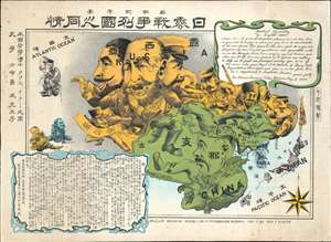
New Commemorative Print of Various Countries Sympathies in the Russo Japanese War. / 崭新纪念画 日露戰爭列國义同情
sold
- Digital Map Information
- Suitable for large format printing
- Full resolution TIFF file
- ICC color profile embedded
- Delivered instantly via download link
The only known example of a 1904 (Meiji 37) Japanese serio-comic style map of Asia illustrating foreign perspectives on the Russo-Japanese War (1904 - 1905). Although previously unknown, if the May 3rd 1904 date is to be believed, this is the second Japanese serio-comic map in the Russo-Japanese War series. The map covers all of Asia and although it does not include Europe, illustrates several western European powers, including France, England, and Germany. (more details)
The only known example of Japan's second Serio-Comic map.
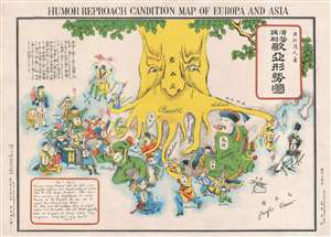
Humor Reproach Candition Map of Europa and Asia. / 滑稽諷刺歐亞形勢圖
sold
- Digital Map Information
- Suitable for large format printing
- File Size: 6.6 MB
- File Type: ZIP / TIFF
- ICC color profile embedded
- Delivered instantly via download link
A previously unknown Meiji 37 or 1904 Japanese broadsheet serio-comic map relating to the Russo-Japanese War. This map was issued in May 28 of 1904, immediately following Japan's successful siege and bombardment Russian held Port Arthur (Dalian). Of the four Japanese serio-comic maps associated with the Russo-Japanese war, this is the second, predated only by Kisaburō Ohara's April 1904 A Humorous Diplomatic Atlas of Europe and Asia. (more details)
The only known example of Japan's second Serio-Comic map.
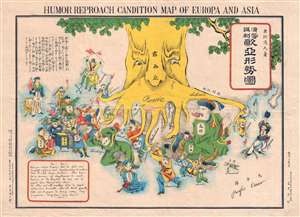
Humor Reproach Candition Map of Europa and Asia. / 滑稽諷刺歐亞形勢圖
sold
- Digital Map Information
- Suitable for large format printing
- File Size: 7.78 MB
- File Type: ZIP / TIFF
- ICC color profile embedded
- Delivered instantly via download link
A previously unknown Meiji 37 or 1904 Japanese broadsheet serio-comic map relating to the Russo-Japanese War. This map was issued in May 28 of 1904, immediately following Japan's successful siege and bombardment Russian held Port Arthur (Dalian). Of the four Japanese serio-comic maps associated with the Russo-Japanese war, this is the second, predated only by Kisaburō Ohara's April 1904 A Humorous Diplomatic Atlas of Europe and Asia. (more details)
Extraordinary manuscript satirical map of Europe during World War II with Chinese Text.
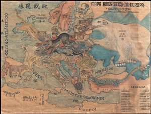
Mapa Humoristico Da Europa - Guerra - 1939 / 歐戰现像
sold
- Digital Map Information
- Suitable for large format printing
- File Size: 8.5 MB
- File Type: ZIP / TIFF
- ICC color profile embedded
- Delivered instantly via download link
An exceptional zoomorphic satirical map of Europe in 1939, here in manuscript form with all text translated into Chinese. This map is based upon a map drawn by the artist António Soares and published by Livraria Franco just weeks after the October 1939 ... (more details)
Rarest and most poignant Russo-Japanese War serio-comic map!

New Funny Map Asia Europa. / 亞細亞歐羅巴嶄新滑稽地圖
sold
- Digital Map Information
- Suitable for large format printing
- File Size: 31.38 MB
- File Type: ZIP / TIFF
- ICC color profile embedded
- Delivered instantly via download link
The holy grail of Japanese Russo-Japanese War (1904 - 1905) chromolithograph serio-comic maps, this is Haru EiDō's July 1904 map lionizing Japanese victories and staging Japan as a major world power and the 'protector' of Asia. This is one of four serio-comic style maps issued sequentially from April through July, 1904, to illustrate and propagandize Japan's near-continuous victories over Russian forces. Unlike some of the others, which also included English content, and therefore were presumably intended for distribution both within and without Japan, this map was intended exclusively for Japanese audiences. (more details)
One of only 2 Japanese serio-comic maps illustrating World War I.
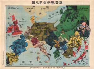
Kokkei Sensou Sekai Chizu. / Ahumoros Wap Map of the World. / 滑馨戰争世界地圖
sold
- Digital Map Information
- Suitable for large format printing
- File Size: 17.14 MB
- File Type: ZIP / TIFF
- ICC color profile embedded
- Delivered instantly via download link
A very rare Japanese broadsheet serio-comic map of Europe and Asia drawn just following the outbreak of World War I. This map was drawn by Ryōzō Tanaka and published by the Shobido Company of Tokyo. The map covers all of Europe and parts of East ... (more details)
Mora's rarest and most desirable map.
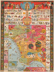
This is a 1942 Jo Mora pictorial map of Los Angeles, California. This is Mora's rarest and most sought-after pictorial map and arguably the best pictorial map of Los Angeles ever issued. It is filled with Mora's unique humor and artistry, which captures Los Angeles' culture, folklore, and history. (more details)
Spectacular pictorial world map illustrating Post-WII situation in Europe and America.
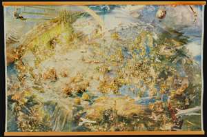
[Oliver Neerlands Bildkarta]
sold
- Digital Map Information
- Suitable for large format printing
- Full resolution TIFF file
- ICC color profile embedded
- Delivered instantly via download link
This is an utterly stunning 1949 pictorial color lithograph wall map of the northern part of the western world by the Norwegian artist Oliver Neerland. The map covers all of North America, the North Atlantic, and Europe as far east as the Caspian Sea, as well as from the North Pole to the Amazon River and Liberia. Lavish illustration depicts historic figures, monuments, art and architecture, animals, airplanes, dirigibles, sailing ships of all types, aircraft characters, and more. (more details)
Mora's rarest and most desirable map.
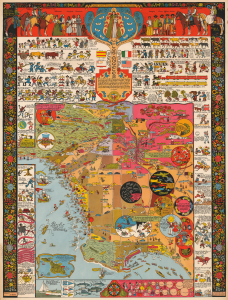
This is a 1942 Jo Mora pictorial map of Los Angeles, California. This is Mora's rarest and most sought-after pictorial map and arguably the best pictorial map of Los Angeles ever issued. It is filled with Mora's unique humor and artistry, which captures Los Angeles' culture, folklore, and history. (more details)
Issued to raise funds to preserve the San Antonio River as the River Walk.
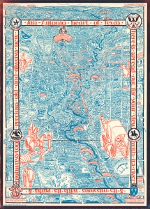
Historic guide map to San Antonio de Bexar and environs.
sold
- Digital Map Information
- Suitable for large format printing
- File Size: 72.53 MB
- File Type: ZIP / TIFF
- ICC color profile embedded
- Delivered instantly via download link
This is Emily Edwards' 1926 historical pictorial map of San Antonio, Texas. This map was issued to raise funds for the preservation of the San Antonio River and the establishment of San Antonio's River Walk - today an iconic part of the city. As an American pictorial map, Edwards' map is early, predating the earliest iconic work of Jo Mora by one year. (more details)
Extremely rare Japanese perspective satirical 'Octopus Map' of Asia.
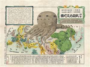
A Humorous Diplomatic Atlas of Europe and Asia. / 滑稽欧亜外交地図 / Kokkei Ō-A Gaikō Chizu.
sold
- Digital Map Information
- Suitable for large format printing
- File Size: 13.3 MB
- File Type: ZIP / TIFF
- ICC color profile embedded
- Delivered instantly via download link
A wonderful example of the rare 1904 Kisaburō Ohara / Shingo Nakamura satirical 'Octopus Map' of Europe. Composed at the outbreak of the Russo-Japanese War (1904 - 1905), Ohara here follows the conventions established by J. J. van Brederode ( Humoristische-Oorlogskaart, 1870) and Fred Rose (Serio-Comic War Map, 1877). These two maps established the convention of satirizing Russian expansionism as a menacing Kraken-like 'Black Octopus.' Whereas Brederode and Rose confine their images to Russia, Ohara has here expanded the idea to encompass all of Eurasia. Russia's eight grasping tentacles extend across Europe and Asia; on many countries they already have a firm grip. Finland, Poland, Crimea, and the Balkan nations are represented as skulls, while tentacles grasp Turkey around the foot and waist, Persia about the neck, and Tibet by the arm. The Trans-Siberian Railway and the South Manchuria Railway, represented by the rightmost tentacle, had by this time extended Russian influence into Manchuria as far as the valuable ice-free Russian stronghold of Port Arthur. As this map was issued in March of 1904, the struggle between Russian and Japan over control of Port Arthur was ongoing. Port Arthur was surrendered to the Japanese, who defeated the Russian Fleet in December of 1905, several months after this map was printed. Ohara sums up the situation in his English language descriptions of the map, printed in the upper left,
Black Octopus is a name newly given to Russia by a certain prominent Englishman. For the black octopus is so avaricious, that he stretches out his eight arms in all directions, and seizes up every thing that comes within his reach. But as it sometimes happens he gets wounded seriously even by a small fish, owing to his too much covetousness. Indeed, a Japanese proverb says: 'Great avarice is like unselfishness.' We Japanese need not to say much on the cause of the present war. Suffice it to say that the further existence of the Black Octopus will depend entirely upon how he comes out of this war. The Japanese fleet has already practically annihilated Russia's naval powers in the Orient. The Japanese army is about to win a signal victory over Russia in Corea and Manchuria. And when ... St. Petersburg? Wait and see! The ugly Black Octopus! Hurrah! Hurrah! for Japan.Certainly the map had a strong message, but who saw it? (more details)
Extremely rare Japanese perspective satirical 'Octopus Map' of Asia.
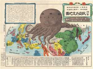
A Humorous Diplomatic Atlas of Europe and Asia. / 滑稽欧亜外交地図 / Kokkei Ō-A Gaikō Chizu.
sold
- Digital Map Information
- Suitable for large format printing
- File Size: 13.69 MB
- File Type: ZIP / TIFF
- ICC color profile embedded
- Delivered instantly via download link
A wonderful example of the rare 1904 Kisaburō Ohara / Shingo Nakamura satirical 'Octopus Map' of Europe. Composed at the outbreak of the Russo-Japanese War (1904 - 1905), Ohara here follows the conventions established by J. J. van Brederode ( Humoristische-Oorlogskaart, 1870) and Fred Rose (Serio-Comic War Map, 1877). These two maps established the convention of satirizing Russian expansionism as a menacing Kraken-like 'Black Octopus.' Whereas Brederode and Rose confine their images to Russia, Ohara has here expanded the idea to encompass all of Eurasia. Russia's eight grasping tentacles extend across Europe and Asia; on many countries they already have a firm grip. Finland, Poland, Crimea, and the Balkan nations are represented as skulls, while tentacles grasp Turkey around the foot and waist, Persia about the neck, and Tibet by the arm. The Trans-Siberian Railway and the South Manchuria Railway, represented by the rightmost tentacle, had by this time extended Russian influence into Manchuria as far as the valuable ice-free Russian stronghold of Port Arthur. As this map was issued in March of 1904, the struggle between Russian and Japan over control of Port Arthur was ongoing. Port Arthur was surrendered to the Japanese, who defeated the Russian Fleet in December of 1905, several months after this map was printed. Ohara sums up the situation in his English language descriptions of the map, printed in the upper left,
Black Octopus is a name newly given to Russia by a certain prominent Englishman. For the black octopus is so avaricious, that he stretches out his eight arms in all directions, and seizes up every thing that comes within his reach. But as it sometimes happens he gets wounded seriously even by a small fish, owing to his too much covetousness. Indeed, a Japanese proverb says: 'Great avarice is like unselfishness.' We Japanese need not to say much on the cause of the present war. Suffice it to say that the further existence of the Black Octopus will depend entirely upon how he comes out of this war. The Japanese fleet has already practically annihilated Russia's naval powers in the Orient. The Japanese army is about to win a signal victory over Russia in Corea and Manchuria. And when ... St. Petersburg? Wait and see! The ugly Black Octopus! Hurrah! Hurrah! for Japan.Certainly the map had a strong message, but who saw it? (more details)
Extremely rare Japanese perspective satirical 'Octopus Map' of Asia.
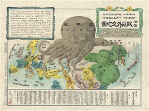
A Humorous Diplomatic Atlas of Europe and Asia. / 滑稽欧亜外交地図 / Kokkei Ō-A Gaikō Chizu.
sold
- Digital Map Information
- Suitable for large format printing
- File Size: 13 MB
- File Type: ZIP / TIFF
- ICC color profile embedded
- Delivered instantly via download link
A wonderful example of the rare 1904 Kisaburō Ohara / Shingo Nakamura satirical 'Octopus Map' of Europe. Composed at the outbreak of the Russo-Japanese War (1904 - 1905), Ohara here follows the conventions established by J. J. van Brederode ( Humoristische-Oorlogskaart, 1870) and Fred Rose (Serio-Comic War Map, 1877). These two maps established the convention of satirizing Russian expansionism as a menacing Kraken-like 'Black Octopus.' Whereas Brederode and Rose confine their images to Russia, Ohara has here expanded the idea to encompass all of Eurasia. Russia's eight grasping tentacles extend across Europe and Asia; on many countries they already have a firm grip. Finland, Poland, Crimea, and the Balkan nations are represented as skulls, while tentacles grasp Turkey around the foot and waist, Persia about the neck, and Tibet by the arm. The Trans-Siberian Railway and the South Manchuria Railway, represented by the rightmost tentacle, had by this time extended Russian influence into Manchuria as far as the valuable ice-free Russian stronghold of Port Arthur. As this map was issued in March of 1904, the struggle between Russian and Japan over control of Port Arthur was ongoing. Port Arthur was surrendered to the Japanese, who defeated the Russian Fleet in December of 1905, several months after this map was printed. Ohara sums up the situation in his English language descriptions of the map, printed in the upper left,
Black Octopus is a name newly given to Russia by a certain prominent Englishman. For the black octopus is so avaricious, that he stretches out his eight arms in all directions, and seizes up every thing that comes within his reach. But as it sometimes happens he gets wounded seriously even by a small fish, owing to his too much covetousness. Indeed, a Japanese proverb says: 'Great avarice is like unselfishness.' We Japanese need not to say much on the cause of the present war. Suffice it to say that the further existence of the Black Octopus will depend entirely upon how he comes out of this war. The Japanese fleet has already practically annihilated Russia's naval powers in the Orient. The Japanese army is about to win a signal victory over Russia in Corea and Manchuria. And when ... St. Petersburg? Wait and see! The ugly Black Octopus! Hurrah! Hurrah! for Japan.Certainly the map had a strong message, but who saw it? (more details)
Original manuscript of iconic pictorial map by Pulitzer Prize cartoonist.
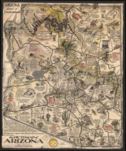
The Picto-Map of Arizona.
sold
- Digital Map Information
- Suitable for large format printing
- File Size: 38.9 MB
- File Type: ZIP / TIFF
- ICC color profile embedded
- Delivered instantly via download link
This is the original pen and ink art, with additional hand color embellishment, of one of the most well-known Golden Age pictorial maps, Reg Manning's 'Arizona', signed and inscribed to fellow editorial cartoonist Jim Williams. The map was drawn in 1935, and copyright registered as the Picto-Map of Arizona, but was not committed to print until the 1938 publication of Reg Manning's Cartoon Guide of Arizona, where it was inserted into a pocket in the back as the 'Cartoon Map of Arizona (more details)
Cowboy Culture, by a cowboy.
![1933 Jo Mora Evolution of the Cowboy Life Rodeo Poster [First Edition]](/mm5/graphics/00000001/M/Cowboys-mora-1933-2-M.jpg "1933 Jo Mora Evolution of the Cowboy Life Rodeo Poster [First Edition]")
The legendarily rare 1933 first edition of Jo Mora's 'Evolution of the Cowboy' is considered his most iconic and influential work. The image celebrates all things cowboy, from the rodeo to saddles, steers, and chuckwagons. It is worth noting that Mora became a cowboy himself, and his depictions of cowboy life, the Salinas Rodeo, and the surrounding culture exhibit realism grounded in experience. (more details)
A most stunning manuscript pictorial map by German female artist illustrating the cacao trade.
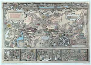
Geschichte des Kakos.
sold
- Digital Map Information
- Suitable for large format printing
- File Size: 29.43 MB
- File Type: ZIP / TIFF
- ICC color profile embedded
- Delivered instantly via download link
This is an utterly stunning c. 1955 unpublished manuscript pictorial map of the world illustrating the history of the cacao trade. The map was drawn by the female graphic designer Ingeborg Gessner (Inge Klatte) for the Stuttgart chocolate company, Eszet (1857 - 1974). It illustrates the world on a loose Mercator projection stylized to conform to German mid-century aesthetics. The map is rich with vignette images illustrating different phases in the history of cacao and phases of cacao harvesting and production. Color coding distinguishes sources of Cacao in South America, Africa, and Australasia. Vignette images along the bottom border trace the development of the cacao trade from its first Europeans exposure when Hernan Cortez arrived at the Aztec capital of Tenochtitlan, to its introduction to the Spanish court, and indigenous use. Copious annotation in German expounds on cacao throughout. (more details)
An idyllic land created at the end of the Great War. A sharp juxtaposition to bomb-blasted Europe.
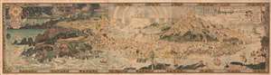
An Anciente Mappe of Fairy Land newly discovered and set forth.
sold
- Digital Map Information
- Suitable for large format printing
- Full resolution TIFF file
- ICC color profile embedded
- Delivered instantly via download link
An extraordinary 6-foot-long masterpiece, this is Bernard Sleigh's 1918 fantastical map of Fairy Land - in tis deluxe first edition. This wonderful map offers a wide birds-eye view panorama of the island of 'Fairy Land' which it describes as 'newly discovered and set forth'. Fairy Land is a wonderful juxtaposition of European fairy tales, literature, and Greek mythology. One can travel from King Arthur's Tomb to Peter Pan's House to the 'Bay of Moaning,' or the visit the roost of Dragons, watch Perseus save Andromeda, chat with Hercules, or visit the 'Harbour of Dreamland.' A red line indicates the route of passage 'From the World' to 'a place that never was and always will be.'
As pointed out by map historian Tim Bryars, this map was printed in 1918, the final year of World War I. Bryars astutely asks,
As pointed out by map historian Tim Bryars, this map was printed in 1918, the final year of World War I. Bryars astutely asks,
Could the map constitute a yearning for a return to pre-1914 Edwardian innocence? Compared with the devastated, bomb-blasted landscape of northern France, this vision of a make-believe land may have seemed a seductive escape for a European society bearing the psychological and physical scars of mass conflict.Another approach to this map is to study it within the context of the Arts and Crafts Movement. Sleigh was a close associate of Robert Morris and this map clearly follows Arts and Crafts Movement ideology. The typeface and decoration are very much in the style of Morris's Kelmscott Press and its embrace of traditional pre-industrial era production techniques. (more details)
Most spectacular pictorial map of Florida.
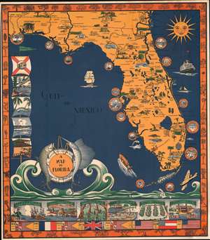
A Map of Florida.
sold
- Digital Map Information
- Suitable for large format printing
- File Size: 56.36 MB
- File Type: ZIP / TIFF
- ICC color profile embedded
- Delivered instantly via download link
A scarce 1935 Eleanore and Richard Foster chromolithograph map of Florida - the most spectacular pictorial map of Florida we have seen. The map is designed on a nautical theme: the sea splashes at the base of the map, forming a cartouche supported by fish and framed by a lifesaver. Coastal cities, including St. Augustine, Daytona Beach, Vero Beach, Palm Beach, St. Petersburg, Miami, Key West, and Fort Meyers, among others, are framed by ship portholes. Smiling from the upper right, the sun shines on the peninsula. Within Florida, both natural resources (pineapples, strawberries, etc.), resort fun (golfing, polo, baseball, sunbathing), and architectural wonders are illustrated. The Overseas Railroad, here in its last year of operation before being destroyed by the Labor Day Hurricane, steams towards Key West. Along the left, Flags illustrate Florida scenes, including alligators and palm trees. A limited breakdown of Florida history appears along the bottom. The border work, in orange, highlights Florida fauna. (more details)
Optimism and danger in Post-WWII Europe and America.
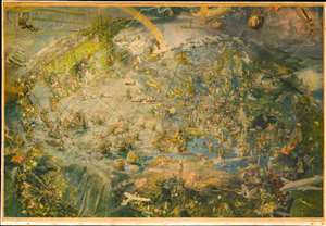
[Oliver Neerlands Bildkarta].
sold
- Digital Map Information
- Suitable for large format printing
- Full resolution TIFF file
- ICC color profile embedded
- Delivered instantly via download link
This is an utterly stunning 1949 pictorial color lithograph wall map of the northern part of the western world by the Norwegian artist Oliver Neerland. The map covers all of North America, the North Atlantic, and Europe as far east as the Caspian Sea, as well as from the North Pole to the Amazon River and Liberia. Lavish illustration depicts historic figures, monuments, art and architecture, animals, airplanes, dirigibles, sailing ships of all types, aircraft adventurers, and more. (more details)
Extremely rare Japanese perspective satirical 'Octopus Map' of Asia.
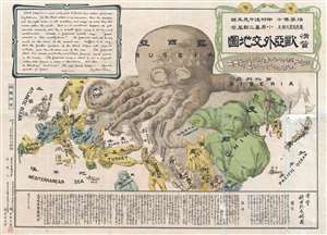
A Humorous Diplomatic Atlas of Europe and Asia. / 滑稽欧亜外交地図 / Kokkei Ō-A Gaikō Chizu.
sold
- Digital Map Information
- Suitable for large format printing
- File Size: 15.14 MB
- File Type: ZIP / TIFF
- ICC color profile embedded
- Delivered instantly via download link
A wonderful example of the rare 1904 Kisaburō Ohara / Shingo Nakamura satirical 'Octopus Map' of Europe. Composed at the outbreak of the Russo-Japanese War (1904 - 1905), Ohara here follows the conventions established by J. J. van Brederode ( Humoristische-Oorlogskaart, 1870) and Fred Rose (Serio-Comic War Map, 1877). These two maps established the convention of satirizing Russian expansionism as a menacing Kraken-like 'Black Octopus.' Whereas Brederode and Rose confine their images to Russia, Ohara has here expanded the idea to encompass all of Eurasia. Russia's eight grasping tentacles extend across Europe and Asia; on many countries they already have a firm grip. Finland, Poland, Crimea, and the Balkan nations are represented as skulls, while tentacles grasp Turkey around the foot and waist, Persia about the neck, and Tibet by the arm. The Trans-Siberian Railway and the South Manchuria Railway, represented by the rightmost tentacle, had by this time extended Russian influence into Manchuria as far as the valuable ice-free Russian stronghold of Port Arthur. As this map was issued in March of 1904, the struggle between Russian and Japan over control of Port Arthur was ongoing. Port Arthur was surrendered to the Japanese, who defeated the Russian Fleet in December of 1905, several months after this map was printed. Ohara sums up the situation in his English language descriptions of the map, printed in the upper left,
Black Octopus is a name newly given to Russia by a certain prominent Englishman. For the black octopus is so avaricious, that he stretches out his eight arms in all directions, and seizes up every thing that comes within his reach. But as it sometimes happens he gets wounded seriously even by a small fish, owing to his too much covetousness. Indeed, a Japanese proverb says: 'Great avarice is like unselfishness.' We Japanese need not to say much on the cause of the present war. Suffice it to say that the further existence of the Black Octopus will depend entirely upon how he comes out of this war. The Japanese fleet has already practically annihilated Russia's naval powers in the Orient. The Japanese army is about to win a signal victory over Russia in Corea and Manchuria. And when ... St. Petersburg? Wait and see! The ugly Black Octopus! Hurrah! Hurrah! for Japan.Certainly the map had a strong message, but who saw it? (more details)
An idylic fantastical land created by Bernard Sleigh at the end of the Great War and which then stood in sharp justaposition to bomb-blasted Europe.
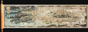
An Anciente Mappe of Fairy Land newly discovered and set forth.
sold
- Digital Map Information
- Suitable for large format printing
- Full resolution TIFF file
- ICC color profile embedded
- Delivered instantly via download link
An extraordinary 6 foot long presentation edition of Bernard Sleigh's 1918 fantastical map of Fairy Land. This wonderful map offers a wide birds-eye view style panorama of the island of 'Fairy Land' which it describes as 'newly discovered and set ... (more details)