
San Francisco (sold)
First printing of one of the most significant and desirable views of San Francisco.
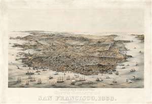
Bird's Eye View of the City and County of San Francisco, 1868.
sold
- Digital Map Information
- Suitable for large format printing
- Full resolution TIFF file
- ICC color profile embedded
- Delivered instantly via download link
An extraordinary Charles Braddock Gifford and William Vallance Gray 3-color chromolithograph bird's-eye view of San Francisco, California, in 1868 - one of the most desirable and influential views of San Francisco ever produced. The view looks southwest on San Francisco Peninsula from an imaginary highpoint to the northeast. The city and bustling harbor are prominent in the foreground while the peninsula's hills and lakes are in the background. The Golden Gate appears at the upper right, and Telegraph Hill at bottom center. (more details)
One of the most significant and desirable views of San Francisco ever published.
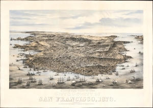
Bird's Eye View of the City and County of San Francisco, 1873.
sold
- Digital Map Information
- Suitable for large format printing
- Full resolution TIFF file
- ICC color profile embedded
- Delivered instantly via download link
This is Charles Braddock Gifford and William Vallance Gray's extraordinary 1873 three-color chromolithograph bird's-eye view of San Francisco, California - one of the most desirable and influential views of San Francisco ever produced. It captures the city in its second distinct phase, having left behind the Gold Rush era and embraced the role of financier of the Pacific Coast, particularly western Nevada's Comstock Lode. (more details)
A superb example of a great rarity of San Francisco.
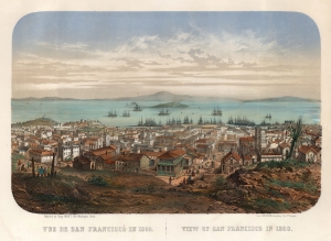
Vue de San Francisco en 1860. / View of San Francisco in 1860.
sold
- Digital Map Information
- Suitable for large format printing
- File Size: 36.57 MB
- File Type: ZIP / TIFF
- ICC color profile embedded
- Delivered instantly via download link
This is an extremely rare c. 1860 Louis Le Breton chromolithograph view map of San Francisco. It was printed in Paris by François-Désiré Gosselin in conjunction with San Francisco publisher Henry Payot. This early iteration of the view is significant for its early - and unique - depiction of Chinese immigration to California, focusing on San Francisco's Chinatown. (more details)
...with every building recognizable!
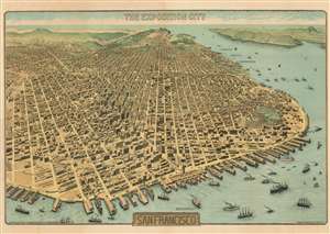
The Exposition City San Francisco.
sold
- Digital Map Information
- Suitable for large format printing
- File Size: 122.73 MB
- File Type: ZIP / TIFF
- ICC color profile embedded
- Delivered instantly via download link
An extraordinary bird's-eye view perspective view and map of San Francisco, risen from the ashes of the 1906 earthquake and fire, ready to retake the world stage by hosting of the Panama-Pacific International Exposition. The view looks westward on San Francisco from a fictional highpoint above today's San Francisco-Oakland Bay Bridge with California Street running dead center. The Embarcadero and docks appear in the foreground, while Golden Gate Park and the Pacific are recognizable in the distance. The Panama-Pacific Exposition, displayed here prospectively, appears at right, near the Golden Gate. Across the bay, in the distance, Mount Tamalpais, with a winding road ascending, is recognizable. The view presents a city fully recovered from a disaster that, just six years prior, destroyed eighty percent of the city. Cartographically the map is noteworthy as it illustrates and names nearly every single building - an astounding achievement and an invaluable record of San Francisco c. 1912. (more details)
San Francisco devastated.
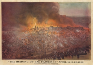
'The Burning of San Francisco' April 18, 19, 20, 1906. The Greatest Conflagration in the History of the World.
sold
- Digital Map Information
- Suitable for large format printing
- File Size: 138.02 MB
- File Type: ZIP / TIFF
- ICC color profile embedded
- Delivered instantly via download link
This is a c. 1906 Schmidt Lithograph Company bird's-eye view of San Francisco burning after the 1906 Great San Francisco Earthquake. It is the best and most dramatic contemporaneous illustration of the Great Fire. (more details)
The first map made by Chinese Americans of San Francisco for the Chinese community.

Map of San Francisco Chinatown. / 美國三藩市華僑區: 詳細圖 / Meiguo Sanfan Shi hua qiao qu : xiang xi tu.
sold
- Digital Map Information
- Suitable for large format printing
- File Size: 22.69 MB
- File Type: ZIP / TIFF
- ICC color profile embedded
- Delivered instantly via download link
An extraordinary record of the early 20th century Chinese experience in San Francisco, this is a rare 1929 map of San Francisco's Chinatown by the San Francisco based Kuomintang (KMT) nationalist J. P. Wong (黃華培, Huang Huapei). This is the first map of Chinatown to be produced by Chinese-Americans for Chinese-American use, and accordingly identifies primarily Chinese-owned businesses and organizations. The map was printed on behalf of the 'Chinese Six Companies' who used it to collect dues, but it was also used by the Tongs, criminal gangs who similarly employed the map to support their extortion racket. (more details)
One of the most graphically striking maps of the San Francisco Bay area.
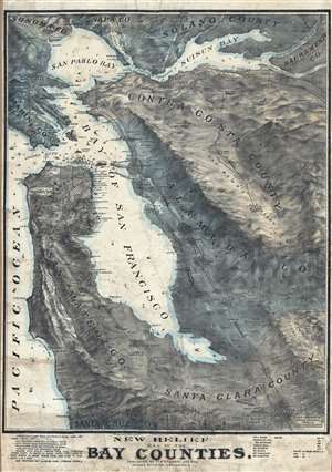
New Relief Map of the Bay Counties.
sold
- Digital Map Information
- Suitable for large format printing
- File Size: 63.9 MB
- File Type: ZIP / TIFF
- ICC color profile embedded
- Delivered instantly via download link
One of the more graphically striking maps of the San Francisco Bay Area to appear in the early 20th century This is a scarce 1905 Whitaker and Ray wall map of the San Francisco Bay Area. The map covers the entire Bay Area, from Napa and San Pablo Bay to San ... (more details)
San Francisco as Ali'gay'tor heaven!
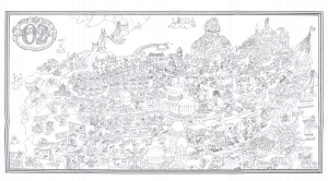
A rare and most humorous 1976 J. Clark Henley pictorial map of San Francisco as the 'gay' paradise, 'Alligator Oz'. The cartography roughly mirrors the northern tip of the San Francisco Peninsula, with the San Francisco Bridge, Alcatraz Island, and the Bay Bridge clearly recognizable. Most structures have been transformed into penis-shaped towers, with the Transamerica Pyramid, the Palace of Fine Arts, the Painted Ladies, and City Hall recognizable. Throughout, homosexual alligators, some in drag, frolic and enjoy themselves, their notably salacious thoughts on clear display. In what would be Golden Gate Park, a parade of happy alli'gay'tors sing,
Oh happy day, we don't have wives who need their hair done, or children who need their stocking filled, so we can need Bill Blass, Vidal Sassoon, Elsa Peretti, and Wilkes Bashford, not to mention a complete collection of toys from Leather Forever…(more details)
Best and largest pictorial map of San Francisco.
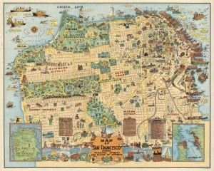
Map of San Francisco Showing Principal Streets and Places of Interest.
sold
- Digital Map Information
- Suitable for large format printing
- File Size: 48.96 MB
- File Type: ZIP / TIFF
- ICC color profile embedded
- Delivered instantly via download link
This is a 1927 Harrison Godwin pictorial map of San Francisco, California - considered the best genre illustration of that city. Comic illustrations appear alongside depictions of San Francisco landmarks, including the Fine Arts Palace, the Twin Peaks, and Fisherman's Wharf. Golden Gate Park appears in detail, with the many animal enclosures, lakes, and buildings all illustrated. The city's schools, churches, hospitals, post offices, and even the U.S. Mint (complete with workers shoveling gold coins into the back of a van) are marked. A surprising number of golfers and golf courses populate the map, with one fellow holding a sign that reads, 'San Francisco has 365 golfing days in the year'. Placards near the bottom border bear facts about the city and list its banks and theaters. Comic panels line the bottom border and present events in San Francisco's history, from its founding to its many fires. An inset in the lower left marks important events, while the inset in the lower right depicts the Greater Bay Area. (more details)
The end of an era.
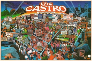
A fascinating view of the Castro neighborhood in San Francisco, produced in 1985 by artist Graham Bruce. It combines elements of a conventional pictorial map of the period (advertisements for local businesses) with a more ethereal aesthetic, celebrating the nightlife of this 'mecca' of LGBTQ culture. However, the view was also produced in the most frightening period of the HIV/AIDS epidemic in San Francisco's gay community, and may have been intended as an elegy for both the people who had died and the culture of gay liberation that was imperiled by the epidemic. (more details)
Awe inspiring nautical chart of th north Pacific Ocean.
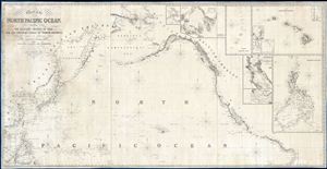
Chart of the North Pacific Ocean, Exhibiting the Eastern Shores of Asia and the Western Coast of North America from the Equator to Behring's Strait with plan, on an enlarge scale, of the Principal Island and Harbours.
sold
- Digital Map Information
- Suitable for large format printing
- DPI: 300
- File Size: 86.53 MB
- File Type: ZIP / TIFF
- ICC color profile embedded
- Delivered instantly via download link
A spectacular and massive 1849 James Imray nautical chart or maritime map of the northern Pacific. Roughly centered on Hawaii, this sprawling chart covers from Hainan and Borneo eastwards to Columbia and Panama, and from the Behring Strait to the Moluccas and the Galapagos Islands (the Equator). The chart is rendered on a Mercator Projection with latitude measured from Greenwich, England. Like most nautical charts, the cartographer offers very little inland detail, but a wealth of maritime data. This includes the identification of various ports and harbors, coastal topography, shoals and other undersea dangers, and countless depth soundings in fathoms. Additionally, the cartographer has noted aspects of various islands that may have been of importance to the mariner, for example Christmas Island has 'Plenty of Turtle, no fresh Water.'
This map is decorated with ten inset maps, from top center, Victoria Harbor (British Columbia), Awatska Bay on the east coast of Kamtschatka, the Mariana or Ladrones Islands (including Guam), the Hawaiian or Sandwich Islands (with four sub-insets: Waiakea or Byron Bay, Hanalei Bay (Kauai), Honolulu Harbor, and Kailua Bay), San Francisco Bay, the Mouth of the Columbia River (including the Fort Astoria settlement), and the Philippine Islands. (more details)
This map is decorated with ten inset maps, from top center, Victoria Harbor (British Columbia), Awatska Bay on the east coast of Kamtschatka, the Mariana or Ladrones Islands (including Guam), the Hawaiian or Sandwich Islands (with four sub-insets: Waiakea or Byron Bay, Hanalei Bay (Kauai), Honolulu Harbor, and Kailua Bay), San Francisco Bay, the Mouth of the Columbia River (including the Fort Astoria settlement), and the Philippine Islands. (more details)
Best and largest pictorial map of San Francisco.
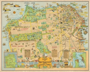
Map of San Francisco Showing Principal Streets and Places of Interest.
sold
- Digital Map Information
- Suitable for large format printing
- File Size: 61.66 MB
- File Type: ZIP / TIFF
- ICC color profile embedded
- Delivered instantly via download link
This is a 1927 Harrison Godwin pictorial map of San Francisco, California - considered the best genre illustration of that city. The map offers a wealth of unique detail that only a local would know - the balloon over the Presidio, a well-known homeless character in Richmond, criminal activity in Sutro Forest, and more. (more details)
Comprehensive guide to San Francisco for Japanese visitors.
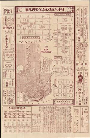
日本人居住区桑港案内地圖 / [San Francisco Guide Map of Neighborhoods with Japanese Residents].
sold
- Digital Map Information
- Suitable for large format printing
- File Size: 31.57 MB
- File Type: ZIP / TIFF
- ICC color profile embedded
- Delivered instantly via download link
This is a unique c. 1930 Japanese-language map of San Francisco, California, published by San Francisco Koshinsha (桑港興信社), a Japanese-American printing house. It highlights the areas of the city with Japanese residents and businesses and was intended for Japanese travelers. (more details)
Fin de Siecle San Francisco.
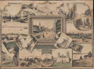
Pacific Coast Scenes Supplement to the Christmas Wasp 1884.
sold
- Digital Map Information
- Suitable for large format printing
- File Size: 404.8 MB
- File Type: ZIP / TIFF
- ICC color profile embedded
- Delivered instantly via download link
A scarce set of vignettes by the acclaimed California painter Christian Jorgensen, published as a supplement to the 1884 Christmas edition of The Wasp, an illustrated satirical news magazine. Focusing on San Francisco and environs, it reinforces the conception Californians hold of their homeland as a land of romance, excitement, and stunning natural beauty. (more details)
The first English mappings of San Diego and San Francisco Bays.
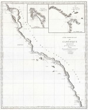
Cote Nord-Ouest de L'Amerique Reconnue par le Cape. Vancouver. 1e Partie.
sold
- Digital Map Information
- Suitable for large format printing
- DPI: 300
- File Size: 13.42 MB
- File Type: ZIP / TIFF
- ICC color profile embedded
- Delivered instantly via download link
One of the great navigator George Vancouver's most important and influential maps, this is Vancouver's 1799 mapping of the California coastline roughly from San Francisco Bay in the north to Santo Domingo, Mexico. Vancouver's exploration of the California ... (more details)
The gold standard for San Francisco maps of the late 19th century.
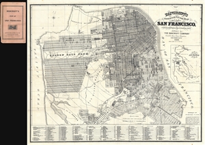
Bancroft's Official Guide Map of City and County of San Francisco, Compiled from Official Maps in Surveyor's Office.
sold
- Digital Map Information
- Suitable for large format printing
- File Size: 24.8 MB
- File Type: ZIP / TIFF
- ICC color profile embedded
- Delivered instantly via download link
A stunning 1887 example of Bancroft's important pocket map of San Francisco, California. This map covers the northern top of the San Francisco Peninsula rom the Pacific Ocean to San Francisco Bay and as far south as Rancho Canada de Guadeloupe. Bancroft ... (more details)
Clipper ship races to China.
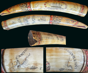
A rare c. 1851 sailer-made scrimshawed walrus tusk celebrating the China Trade and the era of Clipper Ships. The present map focuses on a voyage between Canton (Guangzhou) and San Francisco, possibly the record-breaking 1850 voyage of the clipper ship Stag Hound. (more details)
Berkeley, meet Art Deco!
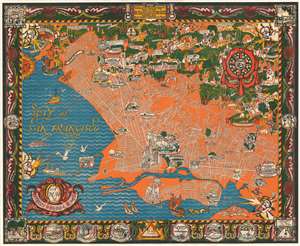
A Map of Berkeley, Oakland and Alameda.
sold
- Digital Map Information
- Suitable for large format printing
- File Size: 110.52 MB
- File Type: ZIP / TIFF
- ICC color profile embedded
- Delivered instantly via download link
This is an outstanding c. 1930 large-format art deco chromolithograph pictorial map of Berkeley, Oakland, and Alamada County, California. The map was issued by the Berkeley artists Michael A. Baltekal-Goodman and Eugene (Eugen) Neuhaus, both then at U.C. Berkeley. Coverage extends from the San Francisco Bay to the Berkeley Hills. The artists have employed a bold color scheme that contracts the blue of San Francisco Bay with the orange and white Berkeley-Oakland street grid. Pictorial elements include vignette illustrations of significant buildings and other attractions. In the hills to the northeast, the focus is more on cultural references, natural beautify, and wildlife. The map features a decorative border with numerous vignettes illustrating historical events, ranging from an 1874 temperance protest to dueling. (more details)
One of the most beautiful early 20th century maps of San Francisco.
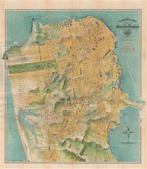
The 'Chevalier' Commercial Pictorial and Tourist Map of San Francisco.
sold
- Digital Map Information
- Suitable for large format printing
- File Size: 21.85 MB
- File Type: ZIP / TIFF
- ICC color profile embedded
- Delivered instantly via download link
One of the most beautiful early 20th century maps of San Francisco. This remarkable 1915 chromolithographic topographical and pictorial map of San Francisco, California was issued by August Chevalier. Named 'The Chevalier' after its author, the map ... (more details)
One of the most beautiful early 20th century maps of San Francisco.
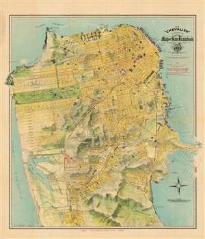
The 'Chevalier' Commercial Pictorial and Tourist Map of San Francisco.
sold
- Digital Map Information
- Suitable for large format printing
- File Size: 44.55 MB
- File Type: ZIP / TIFF
- ICC color profile embedded
- Delivered instantly via download link
This is the 1912 'Chevalier' map of San Francisco, one of the most beautiful early 20th century maps of the city. This remarkable chromolithographic topographical and pictorial map of San Francisco was issued by August Chevalier, a French-born American lithographer living and working in the city. Named 'The Chevalier' after its author, the map covers the city from the Golden Gate Park to Colma, and from the Pacific Ocean to San Francisco Bay. Hunter's Point and Point Lobos, the eastern and western extremities of the peninsula respectively, break through the printed borders into the margins of the map (unusually generous, in the case of this example of the map). The city's grid structure is overlaid on a topographical map much as the real-life San Francisco street grid is overlaid on the peninsula's impressively hilly terrain, producing the city's unique topography of steep streets and sharp sudden inclines. Important buildings are shown pictorially. Overprinting in red identifies proposed tunnels and trolley lines. Proposed improvements and landfills are ghosted in at the eastern side of the city surrounding Hunter's Point. The map is accompanied by a detailed, 96-page guide with art-nouveau covers. Of the variants of Chevalier's map, this is one of the most desirable for its association with the Panama-0Pacific Exposition and bright color. (more details)
Extremely rare letter sheet cartoon illustrating the rise of the San Francisco Committee of Vigilance. Printed in San Francisco after the May 3-4 Great Fire of San Francisco.
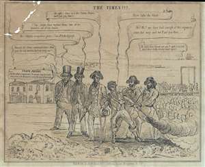
The Times!!!
sold
- Digital Map Information
- Suitable for large format printing
- DPI: 300
- File Size: 2.91 MB
- File Type: ZIP / TIFF
- ICC color profile embedded
- Delivered instantly via download link
An exceptionally rare 1851 Justh, Quirot and Company letter sheet or broadsheet political cartoon satirizing the rise of the San Francisco Committee of Vigilance. In this cartoon, corrupt city officials argue with the Committee of Vigilance over an ... (more details)
Psychedelic pictoral map of San Francisco Epitomizing the Summer of Love.
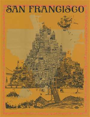
San Francisco.
sold
- Digital Map Information
- Suitable for large format printing
- Full resolution TIFF file
- ICC color profile embedded
- Delivered instantly via download link
Rare, likely one-of-a-kind erroneous proof of this large, attractive and thoroughly far-out 1967 pictorial map of San Francisco. This engaging and exciting view, screen-printed in red, black, and metallic gold, captures the ideal of city in the midst of the Summer of Love, with particular reference to the music that epitomized the year. This example appears to be a unique survival. The print was executed in three colors. The red and the gold, printed first, are registered properly with each other. The black image, added last, has been printed upside-down in relation to the other colors. The error suggests that this example was a test proof; its survival is a testament to the added psychedelic effect presented by the mismatched colors. The poster has four neat tack-holes, indicating that it was put on the wall, and enjoyed for many years despite (or indeed due to) the errors in its execution.
The city’s hilly layout is ludicrously exaggerated, presenting the viewer with a rambunctious pile of iconic references and insider’s jokes springing up from the foot of the Golden Gate Bridge, topped with a ‘Love’ Banner. The image is richly informed with an insider’s knowledge of the scene, providing the viewer with a wealth of detail. Sausalito, in the foreground, features hillside meadows and a ‘Hippy Summer Camp.’ The bucolic scene ends abruptly with a teeming crowd of pedestrians and buses filling the Golden Gate Bridge (though it is not clear whether this horde is entering or leaving the city.) (more details)
The city’s hilly layout is ludicrously exaggerated, presenting the viewer with a rambunctious pile of iconic references and insider’s jokes springing up from the foot of the Golden Gate Bridge, topped with a ‘Love’ Banner. The image is richly informed with an insider’s knowledge of the scene, providing the viewer with a wealth of detail. Sausalito, in the foreground, features hillside meadows and a ‘Hippy Summer Camp.’ The bucolic scene ends abruptly with a teeming crowd of pedestrians and buses filling the Golden Gate Bridge (though it is not clear whether this horde is entering or leaving the city.) (more details)
Rare pictorial map of San Francisco Chinatown by Chinese-American artist.
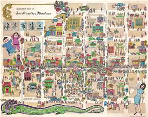
Souvenir Map of San Francisco Chinatown.
sold
- Digital Map Information
- Suitable for large format printing
- Full resolution TIFF file
- ICC color profile embedded
- Delivered instantly via download link
A rare and exceptional map of San Francisco's Chinatown, dating to the Summer of Love, 1967. Drawn by the Chinese-American artist, Bob Chan, the map is oriented to the East and centers on the intersection of Grant Avenue and Washington Street, extending from Powell Street (unlabeled) to Kearny Street, and from California Street to Pacific Avenue. The map aptly illustrates the density of the population, particularly on Grant Avenue. Cartoonish illustrations of prominent local business and historic buildings are noted throughout. A large Chinese dragon sprawls along the bottom of the map. (more details)
San Francisco's late 19th century urbanization.
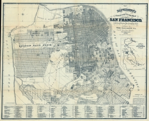
Bancroft's Official Guide Map of City and County of San Francisco, Compiled from Official Maps in Surveyor's Office.
sold
- Digital Map Information
- Suitable for large format printing
- File Size: 64.62 MB
- File Type: ZIP / TIFF
- ICC color profile embedded
- Delivered instantly via download link
A stunning 1891 example of Bancroft's important city map of San Francisco, California. This map, and the Bancroft series in general, represent the finest commercially obtainable cartographic record of San Francisco's urbanization. (more details)
San Francisco as Ali'gay'tor heaven!
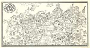
A rare and most humorous 1976 J. Clark Henley pictorial map of San Francisco as the 'gay' paradise, 'Alligator Oz'. The cartography roughly mirrors the northern top of San Francisco Peninsula, with the San Francisco Bridge, Alcatraz Island, and the Bay Bridge clearly recognizable. Most structures have been transformed into penis shaped towers, with some, such as the Transamerica Pyramid, the Palace of Fine Arts, Painted Ladies, and City Hall recognizable. Throughout, homosexual alligators, some in drag, frolic and enjoy themselves, their notably salacious thoughts on clear display. In what would be Golden Gate Park, a parade of happy alli'gay'tors sing,
Oh happy day, we don't have wives who need their hair done, or children who need their stocking filled, so we can need Bill Blass, Vidal Sassoon, Elsa Peretti, and Wilkes Bashford, not to mention a complete collection of toys from Leather Forever…(more details)
An Emotive Contemporary View of the San Francisco Earthquake and Fire.
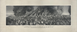
Destruction of San Francisco by Earthquake and Fire, April 18th, 1906. Every Building Shown in the Above Picture Was Destroyed by the Great Fire.
sold
- Digital Map Information
- Suitable for large format printing
- File Size: 130.57 MB
- File Type: ZIP / TIFF
- ICC color profile embedded
- Delivered instantly via download link
A scarce, dramatic representation of the destructive earthquake and fire that struck San Francisco on April 18, 1906, by Francis Ficke. It provides a first-hand view of the great disaster, which remains the most destructive in California's history. (more details)
History of Oakland and San Francisco Bay.
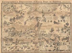
Cartographer's Impressions of Early Days in Eastbay.
sold
- Digital Map Information
- Suitable for large format printing
- File Size: 112.47 MB
- File Type: ZIP / TIFF
- ICC color profile embedded
- Delivered instantly via download link
This is a 1934 Fred Lundy pictorial map of Oakland and San Francisco Bay, California. Pictorial vignettes highlight historical moments from the arrival of Spanish explorers in the 1770s. Among these are turf wars between rival Chinese factions over shrimp fishing rights, and Californians diving off the compass rose. A bull fighting ring appears in Oakland near the bottom border, where fights were held every Sunday until 1854. Two stagecoaches race near the left border. Short texts note the founding of the University of California, the development of wharves along the bay, and provide a sparse history of ferries between Oakland and San Francisco. (more details)
Exeptional view of San Francisco, California by early African American publisher.
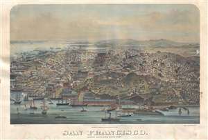
San Francisco. Looking South from North Point.
sold
- Digital Map Information
- Suitable for large format printing
- Full resolution TIFF file
- ICC color profile embedded
- Delivered instantly via download link
A view of San Francisco, California originally published in 1877 by G. T. Brown and company. The present example is a 20th century reproduction issued by John Howell Books, a now defunct California bookstore active from 1912 - 1985. The view bears ... (more details)
San Francisco in the early days of the gold rush.
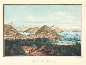
Vue de San Francisco.
sold
- Digital Map Information
- Suitable for large format printing
- DPI: 600
- File Size: 29 MB
- File Type: ZIP / TIFF
- ICC color profile embedded
- Delivered instantly via download link
This is a rare c. 1854 Louis Le Breton view of San Francisco in its early days as an American city - possibly issued as late as the early 20th century. It depicts the settlement in the immediate wake of the California Gold Rush, as its population was rapidly increasing, attracting migrants from throughout the United States and the across the world. (more details)
Depicts the famous San Francisco neighborhood during the 'Summer of Love'.

Hippieville U.S.A., Guide and Map, Haight-Ashbury San Francisco Hippieville
sold
- Digital Map Information
- Suitable for large format printing
- File Size: 41 MB
- File Type: ZIP / TIFF
- ICC color profile embedded
- Delivered instantly via download link
This is a 1967 Elinor Rhodes map of the Haight-Ashbury neighborhood of San Francisco, California during the Summer of Love. The map depicts the neighborhood from Shrader Street to Masonic Avenue and from Page Street to Waller Street. All the businesses along Haight Street are identified, complete with their addresses, from 1811 to 1342 Haight Street. Some of these businesses are labeled with pink text, although it is unclear what sets these establishments apart from the others. Some of the well-known staples of the neighborhood, including The Psychedelic Shop, are included. The Diggers, a local 'community anarchist' group based out of the All Saints' Church on Waller Street is also noted. The Diggers believed in a free society, and built a free medical clinic, established a free store, and gave out free meals on a daily basis, all of which were run by volunteers and donations. A decorative border surrounds the central map, which is depicted as being drawn on a piece of paper being unrolled by two hippies. Flowers stretch across the top of the map, while newspaper clippings adorn the bottom. (more details)
Beautiful chromolithograph advertising map of San Francisco.
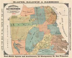
Guide Map of the City of San Francisco.
sold
- Digital Map Information
- Suitable for large format printing
- File Size: 50.89 MB
- File Type: ZIP / TIFF
- ICC color profile embedded
- Delivered instantly via download link
A beautifully produced five-color chromolithograph 1892 map of San Francisco at the end of the 19th century. This map covers all of San Francisco from Lake Merced to the Golden Gate and from the Pacific to San Francisco Bay. Vivid color defines city districts with numbers identifying individual blocks. Various commercial slips and wharves are noted. Red overprinting highlights more active real estate development. The map itself is surrounded by advertising text promoting real estate. (more details)
Incredible early map of Golden Gate Park - only the eastern third has been improved!

Map Showing the Golden Gate Park, the Avenue, and Buena Vista Park
sold
- Digital Map Information
- Suitable for large format printing
- File Size: 8.08 MB
- File Type: ZIP / TIFF
- ICC color profile embedded
- Delivered instantly via download link
This is an 1893 Joseph Britton and Jacques Joseph Rey map of Golden Gate Park. The map depicts Golden Gate Park from the Pacific Ocean to Baker Street and from D Street to H Street and includes both The Panhandle and Buena Vista Park. When compared ... (more details)