
Visscher, Claes Jansz

Claes Jansz Visscher (1587 - 1652) established the Visscher family publishing firm, which were prominent Dutch map publishers for nearly a century. The Visscher cartographic story beings with Claes Jansz Visscher who established the firm in Amsterdam near the offices of Pieter van den Keer and Jadocus Hondius. Many hypothesize that Visscher may have been one of Hondius's pupils and, under examination, this seems logical. The first Visscher maps appear around 1620 and include numerous individual maps as well as an atlas compiled of maps by various cartographers including Visscher himself. Upon the death of Claes, the firm fell into the hands of his son Nicholas Visscher I (1618 - 1679), who in 1677 received a privilege to publish from the States of Holland and West Friesland. The firm would in turn be passed on to his son, Nicholas Visscher II (1649 - 1702). Visscher II applied for his own privilege, receiving it in 1682. Most of the maps bearing the Visscher imprint were produced by these two men. Many Visscher maps also bear the imprint Piscator (a Latinized version of Visscher) and often feature the image of an elderly fisherman - an allusion to the family name. Upon the death of Nicholas Visscher II, the business was carried on by the widowed Elizabeth Verseyl Visscher (16?? - 1726). After her death, the firm and all of its plates was liquidated to Peter Schenk.
Unusual Scriptural Depiction of Jerusalem.
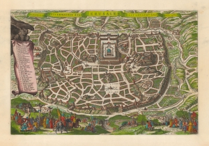
De heylige en wytvermaerde stadt Ierusalem eerst genaemt Salem: Genesis 14, vers 18.
$950.00
Acquire
- Digital Map Information
- Suitable for large format printing
- DPI: 600
- File Size: 49.38 MB
- File Type: ZIP / TIFF
- ICC color profile embedded
- Delivered instantly via download link
This is Claes Janszoon Visscher's scarce 1645 view/map of Biblical Jerusalem, depicting the Temple of Solomon, Herod's Palace, and the city's streets and markets as derived from scriptural sources. Vignettes include Solomon's anointment in the lower right, and the Crucifixion on the lower left. The plan's title is displayed across the top. To the left, a banner held unfurled by an eagle offers a legend of thirty-six numbered features.
Visscher's source is the unacquirable 1630 plan printed by Lünenburg theological publishers Johann and Heinrich Stern. The present work is larger than the Sterm map, and is of a much higher caliber of engraving artistry. While there are certainly earlier depictions of the Holy City based on scriptural sources, most such were based on the fanciful 1584 Christian van Adrichom map. The Stern brothers perspective is both accurate and sophisticated. (more details)
Visscher's source is the unacquirable 1630 plan printed by Lünenburg theological publishers Johann and Heinrich Stern. The present work is larger than the Sterm map, and is of a much higher caliber of engraving artistry. While there are certainly earlier depictions of the Holy City based on scriptural sources, most such were based on the fanciful 1584 Christian van Adrichom map. The Stern brothers perspective is both accurate and sophisticated. (more details)
Influential and Entertaining.
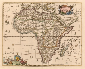
Africae Accurata Tabula ex officina Nic. Visscher.
$1,400.00
Acquire
- Digital Map Information
- Suitable for large format printing
- DPI: 600
- File Size: 19.56 MB
- File Type: ZIP / TIFF
- ICC color profile embedded
- Delivered instantly via download link
This is a c. 1677 example of Nicolas Visscher's 1658 map of Africa. It is a beautifully decorated work, with lively cartouches (see below), eleven ships, a brace of flying fish, and a whale. Visscher's superb engraving affords a superabundance of detail which reveals a contrast between a strong understanding of Africa' coastal region with a deep ignorance of the interior. (more details)
Influential and Entertaining.
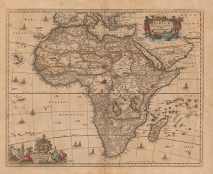
Africae Accurata Tabula ex officina Nic. Visscher.
$1,000.00
Acquire
- Digital Map Information
- Suitable for large format printing
- DPI: 600
- File Size: 23.01 MB
- File Type: ZIP / TIFF
- ICC color profile embedded
- Delivered instantly via download link
This is a c. 1677 second state example of Nicolas Visscher's 1658 map of Africa. It is beautifully decorated, with lively cartouches (see below), eleven ships, a brace of flying fish, and a whale. Visscher's superb engraving affords a superabundance of detail, which reveals a contrast between a strong understanding of Africa's coastal regions and a profound ignorance of the interior. (more details)
A Beautiful Map of the Lower Danube and the Turkish Frontier in Europe
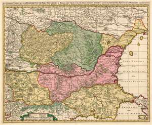
Exactissima Tabula qua tam Danubii Fluvii Pars Inferoir, a Belgrado Urbe usq ad Ejus Ostia, et Minores in eum Influentes Fluvii, quam Regiones Adjacentes, ut Transylvania, Valachia, Moldavia, Bulgaria, Bessarabia et Romonia,, aliqu Ucraniae ac Podoliae Tractus Finitimi Ostenduntur per Nicolaum Visscher.
$750.00
Acquire
- Digital Map Information
- Suitable for large format printing
- DPI: 600
- File Size: 38.38 MB
- File Type: ZIP / TIFF
- ICC color profile embedded
- Delivered instantly via download link
This is a beautiful, contemporary-color example of Nicolas Visscher's c. 1677 map of the lower Danube River, showing the Turkish administrative regions along the Black Sea coast. The map encompasses Transylvania, Serbia, Wallachia, Bulgaria and Romania. Portions of Greece and the Ukraine appear as well. Belgrade, Bucharest, and Istanbul are among the major cities appearing here. This map is notable in naming the Sanjaks, or Ottoman provinces in this contentious frontier region. These extend from the Sanjak of Ochakov (Ukraine on the Black Sea Coast) to the Sanjak of Gallipoli on the Sea of Marmora. Turkish rule in these regions was, by the time this map was produced, so established that many of the place names here are given both in approximations of the Turkish toponymy as well as European. (more details)
French Cartography and Dutch Decorative Engraving.
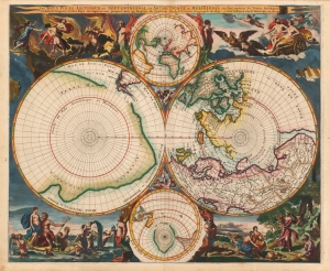
Les Deux Poles Arctique ou Septentrional, et Antarctique ou Meridional, ou Description des Terres Arctiques et Antarctiques ; et des Pays circomvoisins jusques aux 45. Degres de Latitude.
$4,000.00
Acquire
- Digital Map Information
- Suitable for large format printing
- Full resolution TIFF file
- ICC color profile embedded
- Delivered instantly via download link
This is a beautiful example of Peter Mortier's 1696 double-hemisphere map of the northern and southern hemispheres. The primary hemispheres focus on the northern and southern thirds of the world. The secondary hemispheres show the entire world, centered respectively on Paris and its antipodes. (more details)
One of the few views of to show a walled New York.
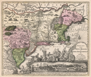
Recens Edita Totius Novi Belgii, in America Septentrionali siti, delineatio cura et sumtibus Tob. Conr. Lotteri, Sac. Caes. Maj. Geographi August. Vind.
$3,500.00
Acquire
- Digital Map Information
- Suitable for large format printing
- DPI: 600
- File Size: 74.88 MB
- File Type: ZIP / TIFF
- ICC color profile embedded
- Delivered instantly via download link
This is Conrad Tobias Lotter's 1757 map of New York, New England, and the mid-Atlantic colonies. It represents the final map in the Jansson-Visscher series. Despite the map's cartography being over a century old, this map continued to capture the idea of this part of the world for Europeans in general and a German audience in particular. (more details)
Magnificent, updated plan of Amsterdam.
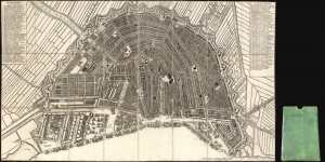
[Plan de la Grande et Fameuse Ville Marchande d'Amsterdam. / Plan van de Wyd Vermaarde en Beroemde Koop Stad Amsterdam.]
$2,000.00
Acquire
- Digital Map Information
- Suitable for large format printing
- Full resolution TIFF file
- ICC color profile embedded
- Delivered instantly via download link
This is the final 1814 Covens and Mortier issue of this large, beautifully engraved Nicolas Visscher II map of Amsterdam. It was originally entitled Plan de la Grande et Fameuse Ville Marchande d'Amsterdam / Plan van de Wyd Vermaarde en Beroemde Koop Stad Amsterdam, but in this state of the plan, the increasingly unfashionable cartouche has been removed, along with the title the plan had borne for a near a century. Architect Daniel Stalpaert initially compiled the plan. It was printed by Nicolas Visscher and was notable as one of the earliest depictions of the iconic ring canals, which were added to the city in the first half of the seventeenth century. The plan is oriented to the south-southwest to display the vibrant port, teeming with ships. It is a magnificently detailed work, with nearly three hundred streets named and numbered. Particularly famous or important structures are illustrated pictorially, as are the windmills built around the city to operate the canal system. (more details)