
China - Japan - Korea (sold)
The Blue Map of China - one of the most important and beautiful maps ever made.
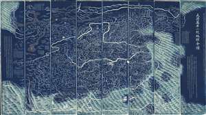
DaQing Wannian Yitong Tianxia Quantu / 大清万年一统天下全图 / All-Under-Heaven Complete Map of the Everlasting Unified Qing Empire
sold
- Digital Map Information
- Suitable for large format printing
- Full resolution TIFF file
- ICC color profile embedded
- Delivered instantly via download link
The legendary Blue Map of China under the Great Qing, one of the rarest, largest, and most aesthetically magnificent Chinese maps ever made. Published in 1811 (Jiaqing 16) in the Qing Dynasty, this Chinese map by Huang Qianren (黃千人, 1694–1771) is of utmost significance. Although ostensibly a map of China, the coverage of this map in fact extends to all lands touched by the influence Qing Empire, including England, Holland, Southeast Asia, Arabia, and Africa. As such it can be considered a political manifesto lionizing the unity and majesty of Qing China as well as a functional administrative document. (more details)
Oldest surviving rubbing of the Dili Tu. /《墬理图》现存最古老碑拓
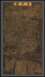
Dili tu. / 墬理圖
sold
- Digital Map Information
- Suitable for large format printing
- File Size: 57.31 MB
- File Type: ZIP / TIFF
- ICC color profile embedded
- Delivered instantly via download link
An outstanding discovery, this is the legendary c. 1247 Dili tu (墬理圖) terrestrial map of China. This is the earliest surviving example of one of the earliest known maps of China produced in the Common Era. The map was drawn by the Chinese polymath Huang Shang (黃裳). Huang's original wood carving, produced around 1194, has long been lost, but the map was engraved in stone in 1247 by Wang Zhiyuan (王致遠). This rubbing comes from that stone and dates to sometime between 1493 and 1602 - making it the oldest known extent rubbing of the Dili tu of China. The present map has been carbon-dated as having been created between 1493 and 1602, with supplementary ink testing verifying the results (these documents are available upon request and accompany the item). (more details)
A cartographic expression of the Qing tribute system, this is the earliest known printed example of the 'Tianxia Quantu' map of Qing China.
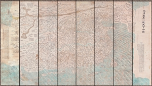
DaQing Wannian Yitong Tianxia Quantu / 大清万年一统天下全图 / All-Under-Heaven Complete Map of the Everlasting Unified Qing Empire
sold
- Digital Map Information
- Suitable for large format printing
- File Size: 89.96 MB
- File Type: ZIP / TIFF
- ICC color profile embedded
- Delivered instantly via download link
A seminal 1806 (Jiaqing 11) Qing Dynasty Chinese map of utmost importance and rarity, this is the earliest known printing of Huang Qianren's (黃千人, 1694–1771) grand and spacious map of the Great Qing Empire of China. Huang Qianren first drew this map ... (more details)
Extraordinary manuscript map collection of Taiwan and Fujian relating to the 1874 Punitive Expedition and the cartography of Le Gendre.
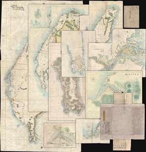
[Taiwan Manuscript Map Collection relating to 1874 Taiwan Punitive Expedition.]
sold
- Digital Map Information
- Suitable for large format printing
- Full resolution TIFF file
- ICC color profile embedded
- Delivered instantly via download link
An extraordinary collection of nine 1874 manuscript maps detailing Taiwan and part of Fujian province, China. The maps were compiled and drafted by one, Sudo Katsuzō (湏藤 or 湏藤勝三) of Tochigi Prefecture, Japan, on an official or semi-official 1874 mission to Taiwan and thence to mainland China. Most of the maps in this set were compiled between March of and June of 1874 and are related to the 1871 Mundan Incident and the subsequent 1874 Taiwan Punitive Expedition. The Taiwan maps are primarily derived from maps drawn by the American Consul to Qing Taiwan Charles William (Guillaum) Joseph Émile Le Gendre's (August 26, 1830 - September 1, 1899) between 1867 and 1873. Others, particularly those of mainland china and Tamsui, are derived from British Admiralty Hydrographic Charts. In addition to the manuscript maps, the collection also contains its original binder and Sudo's application booklet requesting permission to travel from Taiwan to Fujian and Shanghai. (more details)
Ceremonial and Administrative Embodiment of the Qing.
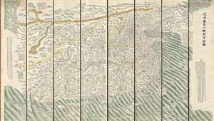
DaQing Wannian Yitong Tianxia Quantu / 大清万年一统天下全图 / All-Under-Heaven Complete Map of the Everlasting Unified Qing Empire
sold
- Digital Map Information
- Suitable for large format printing
- Full resolution TIFF file
- ICC color profile embedded
- Delivered instantly via download link
A seminal 1821 (Daoguang 1) Qing Dynasty Chinese map of utmost importance and rarity, this is Huang Qianren's (黃千人, 1694–1771) grand and spacious map of the Great Qing Empire of China. Although ostensibly a map of China, the coverage of this map in fact extends to all lands touched by the influence Qing Empire, including England, Holland, Southeast Asia, and Africa. As such it can be considered a political manifesto lionizing the unity and majesty of Qing China as well as a functional administrative document. This edition of the map, 1821, was issued to memorialize the reign of the Jiaqing Emperor and celebrate the coming Daoguang reign. (more details)
The last great cartographic masterpiece of Ming China.
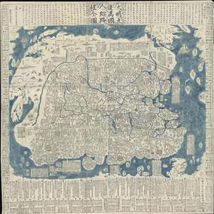
Complete Map of the Nine Border Towns of the Great Ming and of the Human Presence and Travel Routes of the Ten Thousand Countries. / 大明九邊萬國人跡路程全圖 / Dàmíng jiǔ biān wànguó rén jì lùchéng quán tú.
sold
- Digital Map Information
- Suitable for large format printing
- Full resolution TIFF file
- ICC color profile embedded
- Delivered instantly via download link
A rare and extraordinary 1663 (Kangxi 2) xylographic map of Ming China, and indeed the entire world, by Wáng Jūnfǔ (王君甫) issued during the reign of the Kangxi Emperor (1661 – 1722). This massively proportioned map focuses on China, which, bounded on ... (more details)
The last great cartographic masterpiece of Ming China.
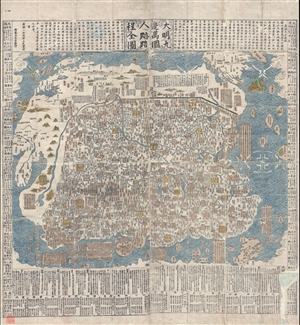
Complete Map of the Nine Border Towns of the Great Ming and of the Human Presence and Travel Routes of the Ten Thousand Countries. / 大明九邊萬國人跡路程全圖 / Dàmíng jiǔ biān wànguó rén jì lùchéng quán tú.
sold
- Digital Map Information
- Suitable for large format printing
- DPI: 300
- File Size: 70.8 MB
- File Type: ZIP / TIFF
- ICC color profile embedded
- Delivered instantly via download link
A rare and extraordinary 1663 (Kangxi 2) xylographic map of Ming China, and indeed the entire world, by Wáng Jūnfǔ (王君甫) issued during the reign of the Kangxi Emperor (1661 – 1722). This massively proportioned map focuses on China, which, bounded on ... (more details)
The largest and most decorative map of Shanghai!
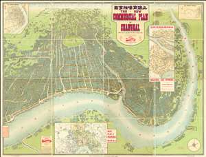
The New Commercial Plan of Shanghai (with which is incorporated the Wharf and Godown Plan). Surveyed, constructed and designed by the Far Eastern Geographical Establishment 6 Kiukiang Road Shanghai.
sold
- Digital Map Information
- Suitable for large format printing
- File Size: 300.62 MB
- File Type: ZIP / TIFF
- ICC color profile embedded
- Delivered instantly via download link
The greatest and most impressive map of Shanghai we have yet seen. Issued in 1915, this is the Far Eastern Geographical Establishment / Edwin John Dingle / H. J. Fruin pictorial view and map of Shanghai. The map is a staggering 83 x 63 inches. The view looks on Shanghai from the east, at a high point across the Huangpu River in what is today the hip Pudong district. In includes the Bund, the Shanghai International Settlement, and the British and French Concessions, as well as the old Chinese City at left. It was issued shortly after the shortly after the 1911 Xinhai Revolution. One can follow Wusong Creek westward into the Horizon, which is illustrated with clouds. Inset maps detail Shanghai and Environs, Road Plan of Shanghai, The Nantao District, and The Rubicon District. (more details)
First Japanese Printed Map to show European geographical information with Buddhist world-view.
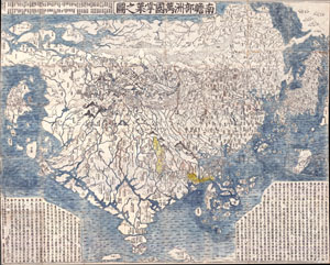
Nansenbushu Bankoku Shoka No Zu (Outline Map of All Countries of the Universe)
sold
- Digital Map Information
- Suitable for large format printing
- Full resolution TIFF file
- ICC color profile embedded
- Delivered instantly via download link
A seminal map. This is the first Japanese printed map to depict the world, including Europe and America, from a Buddhist cosmographical perspective. Printed by woodblock in 1710 (Hoei 7), this map was composed by the Buddhist monk Rokashi Hotan. Inspired ... (more details)
The first Japanese map of the world from a Buddhist cosmographical perspective - a seminal map.
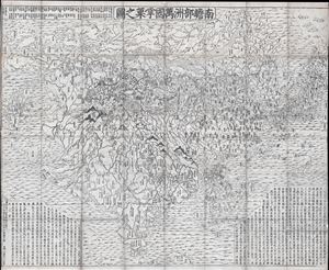
Nansenbushu Bankoku Shoka No Zu (Outline Map of All Countries of the Universe)
sold
- Digital Map Information
- Suitable for large format printing
- DPI: 300
- File Size: 91.94 MB
- File Type: ZIP / TIFF
- ICC color profile embedded
- Delivered instantly via download link
A seminal map of extreme significance. This is the first Japanese printed map to depict the world, including Europe and America, from a Buddhist cosmographical perspective. Printed by woodblock in 1710 (Hoei 7), this map was composed by the Buddhist monk ... (more details)
Ming cartographic heritage.

大明一統二京十三省図 / Great Ming Unification Two Capitals and Thirteen Provinces Map / Da Ming Yi Yong Er Jing Shi San Shen Tu
sold
- Digital Map Information
- Suitable for large format printing
- Full resolution TIFF file
- ICC color profile embedded
- Delivered instantly via download link
This previously unknown 1769 Chinese-language manuscript map of Ming China and Korea is among the most important East Asian cartographic discoveries to emerge in recent years. Monumental in scale and exceptionally detailed, it preserves official Ming Dynasty geographic knowledge long thought lost, likely produced in Tokugawa Japan by descendants of Chinese scholars who fled the fall of the Ming Dynasty in 1644. Rich with elegant calligraphy, extensive topographical and political detail, and numerous textual annotations, the map offers an unparalleled window into the geography, historical memory, and intellectual traditions of the Ming loyalist diaspora. As a unique manuscript with no known counterpart, it represents a once-in-a-lifetime opportunity to acquire an extraordinary artifact of Chinese cartography, Sino-Japanese cultural exchange, and the enduring legacy of the Great Ming. (more details)
The Ming and the Myriad Countries.
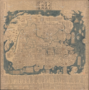
大明九邊萬國人跡路程全圖 / [Complete Map of the Nine Border Crossings of the Great Ming and of the Routes and Settlements of the Myriad Countries].
sold
- Digital Map Information
- Suitable for large format printing
- Full resolution TIFF file
- ICC color profile embedded
- Delivered instantly via download link
An extraordinary 1663 xylographic map of Ming China, and indeed the world by Wang Junfu (王君甫), issued in the second year of the reign of the Kangxi Emperor (r. 1661 – 1722) of the Qing Dynasty. Among other features, it is notable for being dated after the Qing had already displaced the Ming and established a new dynasty, suggesting that it was surreptitiously published and circulated among Ming Loyalists. (more details)
Earliest view of Tsingtao or Qingdao - drawn shortly after the German takeover.
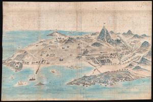
[Tsingtao]
sold
- Digital Map Information
- Suitable for large format printing
- File Size: 78.87 MB
- File Type: ZIP / TIFF
- ICC color profile embedded
- Delivered instantly via download link
This is an outstanding c. 1899 Chinese manuscript view of the city of Qingdao (Tsingtao), China, as it appeared early in the German colonial period. It is hand-painted by an unknown Chinese artist on silk and represents the earliest known image of Qingdao. (more details)
Nansenbushu: First Japanese Printed Map to show European geographical information with Buddhist world-view.
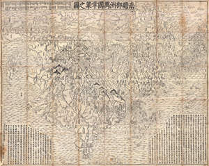
Nansenbushu Bankoku Shoka No Zu (Outline Map of All Countries of the Universe)
sold
- Digital Map Information
- Suitable for large format printing
- DPI: 300
- File Size: 330.31 MB
- File Type: ZIP / TIFF
- ICC color profile embedded
- Delivered instantly via download link
A seminal map of extreme significance. This is the first Japanese printed map to depict the world, including Europe and America, from a Buddhist cosmographical perspective. Printed by woodblock in 1710 (Hoei 7), this map was composed by the Buddhist monk ... (more details)
Map of Song China and its 'Barbarian' neighbors.
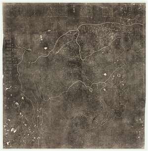
華夷圖 / Hua Yi tu.
sold
- Digital Map Information
- Suitable for large format printing
- Full resolution TIFF file
- ICC color profile embedded
- Delivered instantly via download link
A 19th century Chinese rubbing of the Southern Song Dynasty Fuchang (阜昌) 17 or 1136 CE Hua Yi Tu 華夷圖 map of China. The map illustrates China during the Song Dynasty, covering form the Pamirs to Korea and from the Great Wall (northeast to Heilongjiang), to the south of Hainan Island. The map names numerous geographical features within China and note a few surrounding areas in Korea and India. The written notes in the margins describe additional 'barbarian' peoples. (more details)
…the most outstanding map in the world at that time, and one of the greatest achievements of the Song Dynasty cartographers. - Joseph Needham
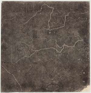
Yu Ji Tu. / Map of the Tracks of Yu Gong. / 禹跡圖
sold
- Digital Map Information
- Suitable for large format printing
- DPI: 600
- File Size: 120.32 MB
- File Type: ZIP / TIFF
- ICC color profile embedded
- Delivered instantly via download link
A 19th century Chinese rubbing of the Southern Song Dynasty 1137 AD Yu Ji Tu 禹跡圖, or Map of the Tracks of Yu Gong. The Yu Ji Tu is one of the earliest and most important Chinese maps ever produced. Issued at a time when European cartographers were producing only vague unscientific T-O style religious map, this Chinese map exhibits a cartographic accuracy and meticulousness comparable to 20th century mapmaking. This is the earliest map to employ a 'Ji Li Hua Fang' rectilinear grid system. The Yu Ji Tu stands out for its precise illustration of China's coasts and complex inland river system, highlighting the Yellow and Yangtze Rivers with their many tributaries. The significance of this map cannot be understated, prompting the British historian Joseph Needham to describe it as,
…the most outstanding map in the world at that time, and one of the greatest achievements of the Song Dynasty cartographers.Although the stele dates to 1137, the contents of the map suggest earlier cartography dating to 1080 -1093. Coverage of the map extends from the Bohai See and the Shandong Peninsula to Hainan and from, roughly, Sichuan, to the South China Sea. The precise grid, for which the map is most famous, breaks China into squares of 100 Li (roughly 31 miles). The coastline, the Yellow River, the Yangtze River and its tributaries, Taihu Lake, Dongting Lake and Poyang Lake are highlighted. This map identifies roughly 380 administrative districts, nearly 80 rivers, 70 mountains, and 5 lakes. (more details)
One of the earliest printed maps of Shanghai and the first Japanese map of Shanghai.
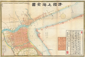
清國上海全圖 / Shinkoku shanhai zenzu. / Qīng guó shànghǎi quán tú. / Qing Shanghai Full Map.
sold
- Digital Map Information
- Suitable for large format printing
- File Size: 29.06 MB
- File Type: ZIP / TIFF
- ICC color profile embedded
- Delivered instantly via download link
An extraordinary discovery, this is the first Japanese map of Shanghai, China, and one of the earliest printed maps of Shanghai. Published in 1873, or Meiji 6, this large format map covers Qing Shanghai's old foreign district. From the conflux of the ... (more details)
Extraordinary early manuscript map of Shanghai, China.
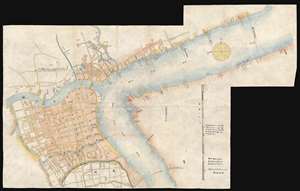
[Shanghai, China]
sold
- Digital Map Information
- Suitable for large format printing
- File Size: 12.79 MB
- File Type: ZIP / TIFF
- ICC color profile embedded
- Delivered instantly via download link
This is an outstanding map of great significance, an 1874 (Tongzhi 13) manuscript version of the 1873 Shinagawa Tadamichi Map of Qing Shanghai, China. This large format map covers Qing Shanghai's old foreign district. From the conflux of the Huangpu River and the Wusong River, the map extends westward to, roughly, the modern day Xisang Middle Road, south to, roughly, Fangbang Middle Road, and eastward along the Huangpu River to the Dalian Road Tunnel. Houses appear in red, roads are yellow, rivers are green, and open land is uncolored. (more details)
Center of Qing Power on Taiwan.
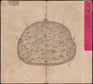
台灣府城全圖 / [Complete Map of the Walled City of Taiwan-fu].
sold
- Digital Map Information
- Suitable for large format printing
- Full resolution TIFF file
- ICC color profile embedded
- Delivered instantly via download link
A remarkable find, this unrecorded c. 1830 manuscript map presents a detailed catalog of Tainan, Taiwan, when the city served as the Qing administrative capital of the island, known as Taiwan-fu. (more details)
Enormous map of China identifying roads and bridges. Shows early Chinese claim to Senkaku / Diaoyu Islands .
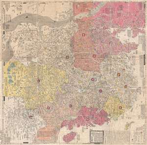
大淸廣輿圖 : 經天合地 : 境域 / Dai Shin kōyozu : keiten gōchi : nikyō jūshishō shii kyōiki. / Enlarged Terrestrial Map of the Great Qing: The Two Capitals, 14 Provinces, and 4 Provinces.
sold
- Digital Map Information
- Suitable for large format printing
- Full resolution TIFF file
- ICC color profile embedded
- Delivered instantly via download link
A rare and important Tenmei 5, Qianlong 50 or 1785 woodblock map of Qing Dynasty China printed in woodblock. This enormous Chinese language map covers from the Tibet and the Kunlun Mountains in western China to Taiwan and the East China Sea, and from ... (more details)
Belcher's influential chart is considered the first British Map of Hong Kong.
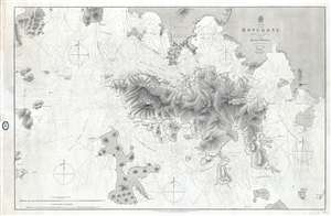
China Hong Kong Surveyed by Captn. Sir Edward Belcher in H.M.S. Sulphur 1841.
sold
- Digital Map Information
- Suitable for large format printing
- File Size: 25.14 MB
- File Type: ZIP / TIFF
- ICC color profile embedded
- Delivered instantly via download link
An iconic map of the utmost importance and rarity, this is the 1864 issue of Edward Belcher's 1843 nautical map of Hong Kong (香港) and vicinity. Belcher's 1841 study is the first detailed British survey of Hong Kong and played a significant role ... (more details)
Extraordinary Shanghai Harbor infrastructure map.
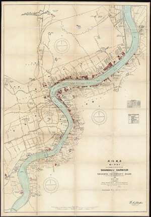
Shanghai Harbour Published by the Whangpoo Conservancy Board.
sold
- Digital Map Information
- Suitable for large format printing
- File Size: 116.98 MB
- File Type: ZIP / TIFF
- ICC color profile embedded
- Delivered instantly via download link
A massive and previously unknown 1927 separate issue dissected wall map of Shanghai, China published by E. C. Stacker and Y. Utne for the Whangpoo Conservancy Board. Centered on the Shanghai Bund, the map details development along the Huangpu River (黄浦江, Whangpoo) from, roughly, the modern district of East Gate (小东门), south to Longhuacun (龙华村). While the focus is on riverside development, wherein individual buildings, docks, diplomatic offices, public utilities, parks, and business are noted; major inland roads are also identified in both English and Chinese. (more details)
Rare first edition of 'one of the most valuable works on China, describing districts never before traversed by Europeans.' (Sabin)
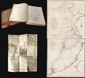
Voyage de l'ambassade de la Compagnie des Indes Orientales Hollandaises, vers l'empereur de la Chine, dans les années 1794 et 1795..
sold
This is a rare 1797/98 Andreas Everardus van Braam Houckgeest two-volume narrative of a VOC embassy to the court of the Qianlong Emperor, in China, and its accompanying maps. During this voyage, Houckgeest became the first American to meet a ... (more details)
One of a kind manuscript map illustrating Tongyeong, an important South Korean city and former naval fort.
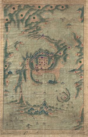
[Tongyeong]
sold
- Digital Map Information
- Suitable for large format printing
- DPI: 300
- File Size: 40.7 MB
- File Type: ZIP / TIFF
- ICC color profile embedded
- Delivered instantly via download link
A scarce early 19th century Korean map of the famous naval base at Tongyeong. The map covers the old naval base, at center, as well as many of the surrounding islands and seas. As with many East Asian maps of this period there is no defined ... (more details)
The best, largest, and most important map of Beijing made before World War II.
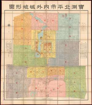
Surveyed Map of Inner City and Outer City, Beijing. /實測北平市内外城地形圖
sold
- Digital Map Information
- Suitable for large format printing
- Full resolution TIFF file
- ICC color profile embedded
- Delivered instantly via download link
The best, largest, and most important map of Beijing made before World War II. This is an astounding wall-sized Republic of China era administrative map of Beijing (Beiping) dating to January 1937 (Mingou 26). This map was issued just months before the Marco Polo Bridge Incident, the Battle of Beiping-Tianjin, the opening of the Second Sino Japanese War, and the subsequent Japanese occupation of Beijing. Measuring 85.5 x 79.5 in (217.17 x 201.93 cm), this enormous work is the largest and most detailed map of Beijing (or Beiping) yet produced. When commissioned by 21st Beijing mayor Yuan Liang (袁良, 1882–1953), more than 10 years had passed since the last major map of Beijing was issued - which was both on a smaller scale and inaccurate. (more details)
First printed map of the Western Hemisphere in one of its earliest printings.
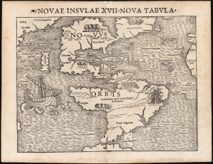
Novae Insulae XVII Nova Tabula.
sold
- Digital Map Information
- Suitable for large format printing
- Full resolution TIFF file
- ICC color profile embedded
- Delivered instantly via download link
This is a superb example of Sebastian Münster's map of America, the first printed map of the Western Hemisphere. This map appeared in the second, 1542 printing of Münster's edition of Ptolemy's Geographia, preceded only by the 1540. As is to be expected for an early printing strike, the image is bold, sharp, and clear. This attractive and evocative map was broadly influential. Münster's Geographia was one of the earliest versions of Ptolemy's work to systematically include maps showing contemporary geographical knowledge, but the map's 1544 inclusion in Münster's magnum opus, Cosmographia Universalis would insure that for more than thirty years during the age of discovery, this map would provide the first glimpse of the New World to the literate European. (more details)
The first printing of the most authoritative and influential map of the siege of the British Legation in Peking (Beijing) during the Boxer Rebellion. Printed in Beijing!
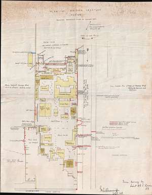
Plan of British Legation Peking shewing defences June to August 1900.
sold
- Digital Map Information
- Suitable for large format printing
- File Size: 6.79 MB
- File Type: ZIP / TIFF
- ICC color profile embedded
- Delivered instantly via download link
An otherwise unobtainable rarity of the utmost historical importance produced in Beijing in the aftermath of the 1900 Boxer Rebellion (Yihetuan Movement, 義和團運動). This is the first, largest, and best official map Beijing's British Legation to illustrate the events of the Boxer Rebellion (1899 - 1901) and the siege of the Legation Quarter.
The map is the product of meticulous on-site surveys and post-siege interviews conducted by British Engineer Henry Edward Colvin Cowie. When the Boxer Rebellion laid siege to the Beijing Legation Quarter, Cowie was drafted from his civilian position with the Indian Public Works Department and sent to Beijing as part of the Bombay Sappers and Miners contingent of the China Relief Expedition. The map was printed on site and bears the Bo. S. and M. (Bombay Sapper's and Miners) imprint, suggesting it was printed with field lithography equipment carried with the Relief Expedition. This is thus the first printing of Cowie's important map and is the source of several subsequent editions which appeared in various influential books and articles on the Boxer Rebellion.
Lithograph signatures of both Lieut. H.E.C. Cowie, and his superior, Lieutenant Colonel George Kenneth Scott-Moncrieff, appear in the lower right. It is also signed in manuscript by Captain Francis Garden Poole (1870 - 1950), an important figure in the defense of the British Legation, this providing the map with an excellent provenance. (more details)
The map is the product of meticulous on-site surveys and post-siege interviews conducted by British Engineer Henry Edward Colvin Cowie. When the Boxer Rebellion laid siege to the Beijing Legation Quarter, Cowie was drafted from his civilian position with the Indian Public Works Department and sent to Beijing as part of the Bombay Sappers and Miners contingent of the China Relief Expedition. The map was printed on site and bears the Bo. S. and M. (Bombay Sapper's and Miners) imprint, suggesting it was printed with field lithography equipment carried with the Relief Expedition. This is thus the first printing of Cowie's important map and is the source of several subsequent editions which appeared in various influential books and articles on the Boxer Rebellion.
Lithograph signatures of both Lieut. H.E.C. Cowie, and his superior, Lieutenant Colonel George Kenneth Scott-Moncrieff, appear in the lower right. It is also signed in manuscript by Captain Francis Garden Poole (1870 - 1950), an important figure in the defense of the British Legation, this providing the map with an excellent provenance. (more details)
The first, best, and earliest map of the Defense of the Legation Quarter during the Boxer Rebellion - original Cyanotype printed in Beijing shortly after the events described.
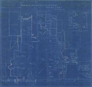
Defence of Foreign Legations, Peking, China, June 20th to Aug. 14th, 1900.
sold
- Digital Map Information
- Suitable for large format printing
- File Size: 26.9 MB
- File Type: ZIP / TIFF
- ICC color profile embedded
- Delivered instantly via download link
A rarity of the utmost historical importance produced in Beijing in the aftermath of the 1900 Boxer Rebellion (Yihetuan Movement, 義和團運動). This is the first, largest, and best official map Beijing's Legation Quarter (Dong Jiaomin Xiang / 東交民巷) to illustrate the events of the Boxer Rebellion (1899 - 1901) and the siege of the Foreign Legations. The map was prepared by the American military engineer Harley Bascom 'Fergie' Ferguson, who was sent to Beijing in 1900 as part of the China Relief Expedition, a multinational emergency force mustered to liberate the besieged legations and suppress the Boxer Rebellion. Produced in cyanotype (blueprint) with Ferguson's own manuscript annotations, this map was issued in miniscule quantities intended only for distribution among military and civilian officials in Beijing – there are only three surviving examples known. Due to the meticulousness and accuracy in illustrating daily progression of the battle, Ferguson's map is today the basis for all subsequent maps of the Legation Quarter's defense. (more details)
Thorough, early defense of the Sea of the West and the Northwest Passage.
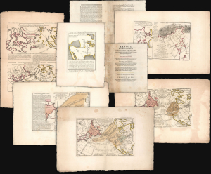
Exposé des Découvertes au Nord de la Grande Mer...
sold
- Digital Map Information
- Suitable for large format printing
- Full resolution TIFF file
- ICC color profile embedded
- Delivered instantly via download link
This is an extremely rare example of Philippe Buache's 1753 Exposé des Découvertes au Nord de la Grande Mer, the essential maps published to support the astonishing geographical theories of Philippe Buache and Joseph Nicolas De l'Isle, presented in August 1752 to the Paris Academie des Sciences. It was then the most complete cartographical defense of Nicolas De l'Isle's 'exposé' of Russian cartographic advances, along with Buache's synthesis of several mappings of the Pacific Northwest, revealing compelling (if ultimately false) evidence of a viable Northwest Passage. These maps were later included in the 1753-1755 Considérations Géographiques, 'the magnum opus of the Delisle-Buache theory of the layout of lands in the North Pacific space,' (Lada-Mocarski, 1969) appearing there in their second states. These six sheets are all first state examples, indicating that the Exposé enjoyed an earlier publication, spurred perhaps by the novelty of Buache and De l'Isle's arguments and the urgency with which the two geographers wished to assuage and rebut critics of their presentation to the Academie. (more details)
First Buddhist map of the world.
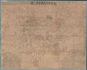
Nansenbushu Bankoku Shoka No Zu (Outline Map of All Countries of the Universe).
sold
- Digital Map Information
- Suitable for large format printing
- DPI: 600
- File Size: 168.79 MB
- File Type: ZIP / TIFF
- ICC color profile embedded
- Delivered instantly via download link
A seminal map of extreme significance. This is the first Japanese printed map to depict the world, including Europe and America, from a Buddhist cosmographical perspective. Printed by woodblock in 1710 (Hoei 7), this map was composed by the Buddhist monk Rokashi Hotan. Inspired by the 1653 publication of Si-yu-ki, a pilgrimage narrative of the Chinese monk Hsuang-Tsang's (602-604) travels to India in search of sacred Sanskrit writings. (more details)
The finest British chart of Hong Kong available during the first Opium War.
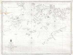
Entrance to the Chou-Kiang or Canton River from the Ouer Islands to Linten.
sold
- Digital Map Information
- Suitable for large format printing
- DPI: 300
- File Size: 6.55 MB
- File Type: ZIP / TIFF
- ICC color profile embedded
- Delivered instantly via download link
A rare and remarkable nautical chart of the utmost significance. This 1840 maritime map of Hong Kong and vicinity is attributed to Captain Daniel Ross, Bombay Marine. During the first Opium War (1839 – 1842), this was the finest and most ... (more details)
Remarkable photographic archive illustrating Pre-War China from the perspective of an American navy man. Includes historically unknown images of graphic war events, General Chiang Kai-shek, and Chinese life.
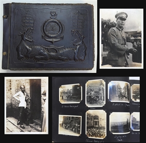
A unique photographic archive covering China and the Philippines in the years of 1927 – 1931, just prior to World War II. The photo archive contains hundreds of photos, loosely arranged thematically and chronologically, following the ... (more details)