
Scandinavia - Denmark (sold)
One of the most desirable printed maps of any part of the world, in original color.
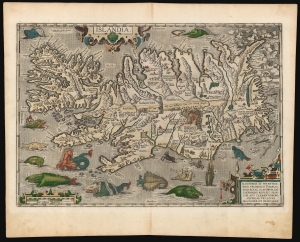
Islandia.
sold
- Digital Map Information
- Suitable for large format printing
- Full resolution TIFF file
- ICC color profile embedded
- Delivered instantly via download link
This is a superb example of Abraham Ortelius' 1587 map of Iceland, in a desirable 1603 Vrients edition with original color. Ortelius' Islandia is arguably the most famous decorative map, being the 'monster map' par excellence, as it presents a menagerie of the sea monsters typically found on early maps. The map is geographically important as well. Beyond strongly evoking Iceland's astonishing terrain with its vigorously engraved mountains, it is remarkably accurate since it is the first map of Iceland derived from the contemporaneous work of an Icelander, Gudbrandur Thorlaksson (Guðbrandur Þorláksson; c. 1542 - 1627). (more details)
One of the most desirable maps of any part of the world, ever printed.
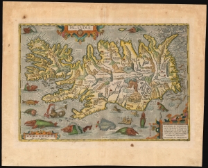
Islandia.
sold
- Digital Map Information
- Suitable for large format printing
- Full resolution TIFF file
- ICC color profile embedded
- Delivered instantly via download link
This is a handsome example of Abraham Ortelius' 1587 map of Iceland, in its 1612 Italian text edition. Ortelius' Islandia is arguably the most famous decorative map, being the 'monster map' par excellence, as it presents a menagerie of sea monsters typically found on early maps. The map is geographically important as well. Beyond strongly evoking Iceland's astonishing terrain with its vigorously engraved mountains, it is remarkably accurate since it is the first map of Iceland derived from the work of an Icelander, Gudbrandur Thorlaksson (Guðbrandur Þorláksson; c. 1542 - 1627). (more details)
One of the most desirable maps of any part of the world, ever printed.
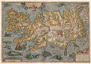
Islandia.
sold
- Digital Map Information
- Suitable for large format printing
- Full resolution TIFF file
- ICC color profile embedded
- Delivered instantly via download link
This is a beautiful example of the Vrients issue of Abraham Ortelius' 1587 map of Iceland. Ortelius' Islandia is arguably the most famous decorative map, being the 'monster map' par excellence, as it presents a menagerie of sea monsters typically found on early maps. The map is geographically important as well. It strongly evokes Iceland's astonishing terrain with its vigorously engraved mountains, and it is remarkably accurate since it is the first map of Iceland based on reports of an Icelander, Gudbrandur Thorlaksson (Guðbrandur Þorláksson; c. 1542 0 1627). (more details)
One of the most desirable printed maps of any part of the world.
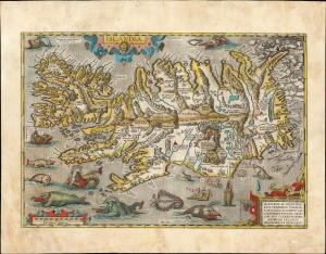
Islandia.
sold
- Digital Map Information
- Suitable for large format printing
- Full resolution TIFF file
- ICC color profile embedded
- Delivered instantly via download link
This is an attractive example of Abraham Ortelius' 1587 map of Iceland. Ortelius' Islandia is arguably the most famous decorative map, being the 'monster map' par excellence, presenting a menagerie of the sea monsters typically found on early maps. The map is geographically important as well. Beyond strongly evoking Iceland's astonishing terrain with its vigorously engraved mountains, it is remarkably accurate since it is the first map of Iceland derived from the contemporaneous work of an Icelander, Gudbrandur Thorlaksson (Guðbrandur Þorláksson; c. 1542 - 1627). (more details)
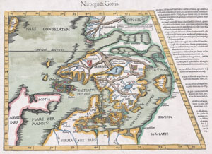
Norbegia & Gottia.
sold
- Digital Map Information
- Suitable for large format printing
- DPI: 300
- File Size: 5.91 MB
- File Type: ZIP / TIFF
- ICC color profile embedded
- Delivered instantly via download link
A masterpiece. This is an important early map of Scandinavia by cartographer Martin Waldseemuller. It is heavily based on the similar map by Claudius Clavus, which appeared in the 1425 Ulm edition of Ptolemy's Geographia. The most notable difference between this ... (more details)
Bestiary of fantastical northern monsters.
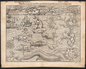
Monstra marina et terrestria, quae passim in partibus aquilonis inveniuntir.
sold
- Digital Map Information
- Suitable for large format printing
- DPI: 600
- File Size: 32.12 MB
- File Type: ZIP / TIFF
- ICC color profile embedded
- Delivered instantly via download link
An attractive printing of what is often euphemistically referred to as Munster's Monsters, this is Sebastian Münster's bestiary of sea serpents and other astonishing monsters, some fictional, some real. The image first appeared in the expanded 1550 editions of Munster's Cosmographia, a work which for more than half a century provided the European literate layperson their best source of information about the world. Most of the beasts here are derived from a 1539 map of Scandinavia by Olaus Magnus. As fanciful as these creatures may appear, many depict factual creatures that Scandinavian sailors and whalemen occasionally encountered. Among the more recognizable beasts are various forms of whales with obvious blowholes, at least two enormous lobsters, a sea serpent (possibly an oarfish), the whale fish (white fish at center, an Orca), and something that might very well be a walrus. A pelican (letter R) is recognizably depicted, and it is described on the verso including part of its scientific name (Onocrotalus.) Of course, there are fictional sea monsters too, including a pig faced sea beast, apparently seen by sailors in 1537, and the Sea Buffalo, something that looks like a cross between a bull and a fish. (more details)
Bestiary of fantastical northern monsters.
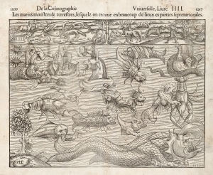
Les marins monstres et terrestres, lesquelz on trouve en beaucoup de lieux es parties septentrionales.
sold
- Digital Map Information
- Suitable for large format printing
- DPI: 600
- File Size: 31.37 MB
- File Type: ZIP / TIFF
- ICC color profile embedded
- Delivered instantly via download link
An attractive printing of what is often euphemistically referred to as Munster's Monsters, this is Sebastian Münster's bestiary of sea serpents and other astonishing monsters, some fictional, some real. The image first appeared in the expanded 1550 editions of Munster's Cosmographia, a work which for more than half a century provided the European literate layperson their best source of information about the world. Most of the beasts here are derived from a 1539 map of Scandinavia by Olaus Magnus. As fanciful as these creatures may appear, many depict factual creatures that Scandinavian sailors and whalemen occasionally encountered. Among the more recognizable beasts are various forms of whales with obvious blowholes, at least two enormous lobsters, a sea serpent (possibly an oarfish), the whale fish (white fish at center, an Orca), and something that might very well be a walrus. Of course, there are fictional sea monsters too, including a pig faced sea beast, apparently seen by sailors in 1537, and the Sea Buffalo, something that looks like a cross between a bull and a fish. (more details)
Bestiary of fantastical northern monsters.
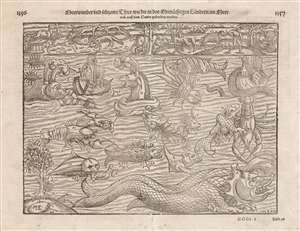
Meerwunder und seltzame Thier wie die in den Mitnåchtigen Låndern im Meer.
sold
- Digital Map Information
- Suitable for large format printing
- Full resolution TIFF file
- ICC color profile embedded
- Delivered instantly via download link
Often euphemistically referred to as Münster's Monsters, this is Sebastian Münster's bestiary of sea serpents and other astonishing monsters, some fictional, some real. The image first appeared in the expanded 1550 editions of Münster's Cosmographia, a work which for more than half a century provided the European literate layperson their best source of information about the world. Most of the beasts here are derived from a 1539 map of Scandinavia by Olaus Magnus. As fanciful as these creatures may appear, many depict actual creatures that Scandinavian sailors and whalemen occasionally encountered. Among the more recognizable beasts are whales identifiable by the spouts from their blowholes; two enormous lobsters (one of which is dragging a hapless sailor into the depths), a sea serpent (possibly an oarfish), the whale fish, and something that might very well be a walrus. There are fictional sea monsters too, including a pig faced sea beast, apparently seen by sailors in 1537, and the Sea Buffalo, something that looks like a cross between a bull and a fish. (more details)
Bestiary of fantastical northern monsters.
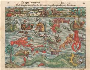
Mostri marini e terrestri, che si trouano in ogni luogo nelle parti d'aquilone.
sold
- Digital Map Information
- Suitable for large format printing
- Full resolution TIFF file
- ICC color profile embedded
- Delivered instantly via download link
Often euphemistically referred to as Munster's Monsters, this is Sebastian Münster's bestiary of sea serpents and other astonishing monsters, some fictional, some real. The image first appeared in the expanded 1550 editions of Munster's Cosmographia, a work which for more than half a century provided the European literate layperson their best source of information about the world. Most of the beasts here are derived from a 1539 map of Scandinavia by Olaus Magnus. As fanciful as these creatures may appear, many depict factual creatures that Scandinavian sailors and whalemen occasionally encountered. Among the more recognizable beasts are various forms of whales with obvious blowholes, at least two enormous lobsters, a sea serpent (possibly an oarfish), the whale fish (white fish at center, an Orca), and something that might very well be a walrus. Of course, there are fictional sea monsters too, including a pig faced sea beast, apparently seen by sailors in 1537, and the Sea Buffalo, something that looks like a cross between a bull and a fish. (more details)
Bestiary of fantastical northern monsters.
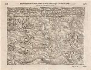
Meerwunder und seltzame Thier/ wie die in den Mitnåchtigen Låndern im Meer.
sold
- Digital Map Information
- Suitable for large format printing
- Full resolution TIFF file
- ICC color profile embedded
- Delivered instantly via download link
Often euphemistically referred to as Munster's Monsters, this is Sebastian Munster's bestiary of sea serpents and other terrifying monsters, some fictional, some real, that was included in Munster's Cosmographia, which for more than half a century provided the European literate layperson their best source of information about the world away from their homes. Most of the beasts here are derived from a 1539 map of Scandinavia drawn by Olaus Magnus. Although Munster's Monsters may initially seem fabulous and scary, many are based upon or outright depictions of the factual creatures that Scandinavian sailors and whalemen actually encountered. This woodcut was composed by the Swiss artist Hans Rudolf Manuel Deutsch, who produced many of Munster's woodcuts. The actual Formschneider is unknown beyond his initials, M-F, which appear along with Deutsch's 'HR-MD.'
Among the more recognizable beasts are various forms of whales with obvious blowholes, at least two enormous lobsters, a sea serpent (probably an oarfish), the whale fish (white fish at center, an Orca), and something that might very well be a walrus. Of course, there are fictional sea monsters too, including a pig faced sea beast, apparently seen by sailors in 1537, and the Sea Buffalo, something that looks like a cross between a bull and a fish.
Although much is made of Munster's sea creatures, it should be noted that his map also illustrates land based fauna, most of which are far more realistic. These include reindeer, beavers, sables, bears, a wolverine, snakes, and what might be some sort of large cat. In the lower left, there is a tree populated by 'duckbirds,' a curious kind of avian that Munster claims 'grows on trees' but which, in his lifetime, had not been seen for some 400 years.
Although not properly a map, Munster included this catalog of beasts in his Cosmographia to illustrate the natural world. Today we might look at a book like the Cosmographia and consider it an atlas for its many maps, but the work itself is more accurately an attempt to describe, as the name suggests, the entire cosmos. It included descriptions of flora, fauna, geological and astronomical observations, historical notes, and cultural (some might even say anthropological) commentary. (more details)
Among the more recognizable beasts are various forms of whales with obvious blowholes, at least two enormous lobsters, a sea serpent (probably an oarfish), the whale fish (white fish at center, an Orca), and something that might very well be a walrus. Of course, there are fictional sea monsters too, including a pig faced sea beast, apparently seen by sailors in 1537, and the Sea Buffalo, something that looks like a cross between a bull and a fish.
Although much is made of Munster's sea creatures, it should be noted that his map also illustrates land based fauna, most of which are far more realistic. These include reindeer, beavers, sables, bears, a wolverine, snakes, and what might be some sort of large cat. In the lower left, there is a tree populated by 'duckbirds,' a curious kind of avian that Munster claims 'grows on trees' but which, in his lifetime, had not been seen for some 400 years.
Although not properly a map, Munster included this catalog of beasts in his Cosmographia to illustrate the natural world. Today we might look at a book like the Cosmographia and consider it an atlas for its many maps, but the work itself is more accurately an attempt to describe, as the name suggests, the entire cosmos. It included descriptions of flora, fauna, geological and astronomical observations, historical notes, and cultural (some might even say anthropological) commentary. (more details)
One of the earliest maps to show Mercator's speculative Arctic islands, the apocryphal Friesland, and Zeno's fraudlent version of Labrador, Estotiland.
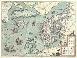
Septentrionalum Regionum Desrip.
sold
- Digital Map Information
- Suitable for large format printing
- DPI: 300
- File Size: 11.16 MB
- File Type: ZIP / TIFF
- ICC color profile embedded
- Delivered instantly via download link
One of Abraham Ortelius' most interesting maps, this is his 1570 map of Scandinavia and the Arctic. During the Age of Discovery, these northern parts of the world represented regions as remote and unfamiliar as the coasts of America, Africa, and Asia. (more details)
First Atlas Map of the North Parts of the World.
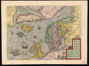
Septentrionalium Regionum Desrip.
sold
- Digital Map Information
- Suitable for large format printing
- Full resolution TIFF file
- ICC color profile embedded
- Delivered instantly via download link
A handsome example of one of Abraham Ortelius' most interesting maps, his 1570 map of Scandinavia and the Arctic. During the Age of Discovery, these northern parts of the world represented regions as remote and unfamiliar as the coasts of America, Africa, and Asia. (more details)
First Atlas Map of the North Parts of the World.
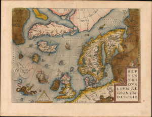
Septentrionalium Regionum Desrip.
sold
- Digital Map Information
- Suitable for large format printing
- Full resolution TIFF file
- ICC color profile embedded
- Delivered instantly via download link
A handsome example of one of Abraham Ortelius' most interesting maps, his 1570 map of Scandinavia and the Arctic. During the Age of Discovery, the Arctic was as remote and unfamiliar as the coasts of America, Africa, or Asia. This map played a role in propagating several cartographic fallacies, including the Zeno Fraud: Frisland, Estotiland, Drogeo. The present example features warm, original color. (more details)
British propaganda celebrating 'victory' in the Battle of the Atlantic.
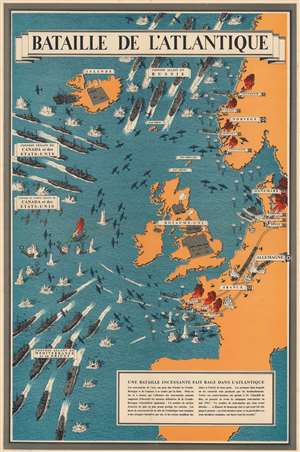
Bataille de l'Atlantique.
sold
- Digital Map Information
- Suitable for large format printing
- File Size: 84.51 MB
- File Type: ZIP / TIFF
- ICC color profile embedded
- Delivered instantly via download link
This is a 1943 Frederick Donald Blake pictorial propaganda broadside of the Battle of the Atlantic - one of the longest and bloodiest campaigns of World War II (1939 - 1945). (more details)
Bestiary of fantastical northern monsters.
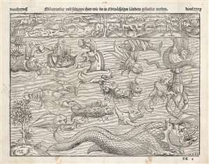
Mœrwunder und seltzame thier / wie die in den mitnåchtigen lándern gefunden werden.
sold
- Digital Map Information
- Suitable for large format printing
- Full resolution TIFF file
- ICC color profile embedded
- Delivered instantly via download link
An attractive 1558 printing of what is often euphemistically referred to as Munster's Monsters, this is Sebastian Münster's bestiary of sea serpents and other astonishing monsters, some fictional, some real. The image first appeared in the expanded 1550 editions of Munster's Cosmographia, a work which for more than half a century provided the European literate layperson their best source of information about the world. Most of the beasts here are derived from a 1539 map of Scandinavia by Olaus Magnus. As fanciful as these creatures may appear, many depict factual creatures that Scandinavian sailors and whalemen occasionally encountered. Among the more recognizable beasts are various forms of whales with obvious blowholes, at least two enormous lobsters, a sea serpent (possibly an oarfish), the whale fish (possibly an Orca), and something that might very well be a walrus. Of course, there are fictional sea monsters too, including a pig faced sea beast, apparently seen by sailors in 1537, and the Sea Buffalo, something that looks like a cross between a bull and a fish. (more details)
One of the earliest impressions of the only large-scale depiction of Martin Behaim's map.
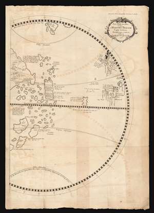
Pars Globi terrestris Ao. 1492. Martino Behaim Equite Lusitano Norimbergae confecti. Delineavit Christoph. Theoph. de Murr. 1778.
sold
- Digital Map Information
- Suitable for large format printing
- Full resolution TIFF file
- ICC color profile embedded
- Delivered instantly via download link
This fascinating and unique map, printed in 1787, is one of the earliest acquirable representations of the western hemisphere as it appeared on the oldest surviving globe - Martin Behaim's Erdapfel, a manuscript globe produced in Nuremberg in 1492. Behaim's globe was influential and fascinating, offering a glimpse on the imagined form of the world at the time of Columbus. Behaim's fame, amplified by supporters over the following centuries, led some to scholars to suppose he himself traveled across the Atlantic to America, or at least that supplied the theory to Columbus that the Atlantic route to the East Indies was navigable. The present map, copied from the western hemisphere of Behaim's globe by the historian Christoph Gottlieb von Murr, was produced as evidence that Behaim had neither stolen a march on Columbus, nor guided him. Having marshaled his evidence, von Murr says that 'history, and the globe destroy absolutely all these so - called facts, and prove (Behaim) had no knowledge of America.' (more details)
Bestiary of fantastical northern monsters.
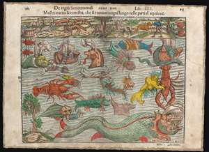
Mostri marini e terrestri, che si trouano in ogni luogo nelle parti d'aquilone.
sold
- Digital Map Information
- Suitable for large format printing
- Full resolution TIFF file
- ICC color profile embedded
- Delivered instantly via download link
Often euphemistically referred to as Munster's Monsters, this is Sebastian Münster's bestiary of sea serpents and other astonishing monsters, some fictional, some real. The image first appeared in the expanded 1550 editions of Munster's Cosmographia, a work which for more than half a century provided the European literate layperson their best source of information about the world. Most of the beasts here are derived from a 1539 map of Scandinavia by Olaus Magnus. As fanciful as these creatures may appear, many depict factual creatures that Scandinavian sailors and whalemen occasionally encountered. Among the more recognizable beasts are various forms of whales with obvious blowholes, at least two enormous lobsters, a sea serpent (possibly an oarfish), the whale fish (white fish at center, an Orca), and something that might very well be a walrus. Of course, there are fictional sea monsters too, including a pig faced sea beast, apparently seen by sailors in 1537, and the Sea Buffalo, something that looks like a cross between a bull and a fish. (more details)
First edition of the the second map of Iceland based on local information.
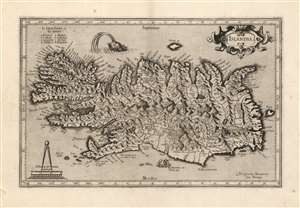
Islandia.
sold
- Digital Map Information
- Suitable for large format printing
- Full resolution TIFF file
- ICC color profile embedded
- Delivered instantly via download link
This is a beautiful strike of Gerhard Mercator's map of Iceland, in a beautiful 1595 first edition example. It is the second map of Iceland to appear in a modern atlas, and the second map overall of Iceland based on data originating from an Icelander, placing it among the first accurate maps of the island. Mercator's map first appeared in 1595, only five years after Abraham Ortelius' famous map; both maps shared the same ultimate source: Guðbrandur Þorláksson, Bishop of Holar. (more details)
The Northern Limits of Geographical Knowledge in the Age of Discovery
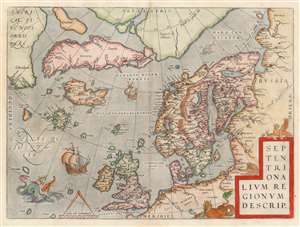
Septentrionalium Regionum Desrip.
sold
- Digital Map Information
- Suitable for large format printing
- DPI: 600
- File Size: 49.65 MB
- File Type: ZIP / TIFF
- ICC color profile embedded
- Delivered instantly via download link
One of Abraham Ortelius' most interesting maps, this is his 1570 map of Scandinavia and the Arctic. During the Age of Discovery, these north parts of the world represented regions as remote and unfamiliar as the coasts of America, Africa, and Asia. The map covers the northern regions from the English Channel to the just south of the North Pole and from America to Russia, including England, Scandinavia, Finland, Denmark, Iceland, and Greenland, as well as parts of America (Estotiland), the apocryphal island of Frisland, and Mercator's speculative Arctic islands. (more details)
Scarce, early, Scandinavia.
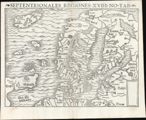
Septentrionales Regiones. XVIII. No. Tab.
sold
- Digital Map Information
- Suitable for large format printing
- Full resolution TIFF file
- ICC color profile embedded
- Delivered instantly via download link
This is Sebastian Münster's scarce woodcut map of Scandinavia and the northern parts of the European world, first added to his Cosmographia in 1544; this example is of its second, 1545 printing. It is one of the few examples of this map printed during its author's lifetime. It is an important work, being the earliest acquirable derivative of the 1539 milestone Olaus Magnus Carta Marina, then the most correct and detailed depiction of Scandinavia. The present work is, moreover, one of the scarcest of Münster's maps. Of more than 30 editions of Cosmographia, this map only appeared in nine, and in only two editions of his Ptolemy. (more details)
North Part of the World Known to Europe in the Age of Discovery.
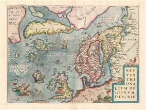
Septentrionalum Regionum Desrip.
sold
- Digital Map Information
- Suitable for large format printing
- Full resolution TIFF file
- ICC color profile embedded
- Delivered instantly via download link
One of Abraham Ortelius' most interesting maps, this is his 1570 map of the Arctic, here in a transitional example between the first and second states as recorded in van den Broecke. The map covers the northern regions from the English Channel to the just south of the North Pole and from America to Russia, including England, Scandinavia, Finland, Denmark, Iceland, and Greenland, as well as parts of America (Estotiland), the apocryphal island of Friesland, and Mercator's speculative Arctic islands. (more details)
First generally acquirable Map of Scandinavia, Iceland and Greenland.
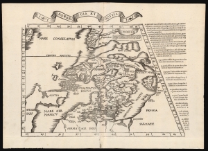
Norbegia et Gottia.
sold
- Digital Map Information
- Suitable for large format printing
- Full resolution TIFF file
- ICC color profile embedded
- Delivered instantly via download link
This is Lorenz Fries' 1522 map, in a 1535 edition, of one of the earliest maps to focus on the northern parts of Europe, including Iceland and Greenland. It is one of the earliest acquirable maps to include the geography of Claudius Clavus (1388 - 14??). (more details)
An unusual separate issue without verso text.
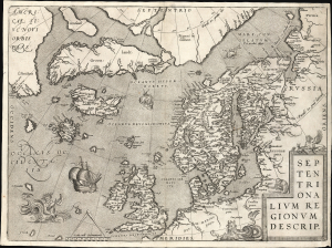
Septentrionalium Regionum Desrip.
sold
- Digital Map Information
- Suitable for large format printing
- File Size: 22.83 MB
- File Type: ZIP / TIFF
- ICC color profile embedded
- Delivered instantly via download link
A handsome example of one of Abraham Ortelius' most interesting maps, his 1570 map of Scandinavia and the Arctic. During the Age of Discovery, these northern parts of the world represented regions as remote and unfamiliar as the coasts of America, Africa, and Asia. (more details)
1641 Spanish Text Edition - only 25 printed.
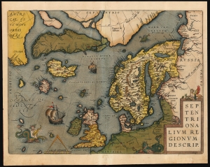
Septentrionalium Regionum Desrip.
sold
- Digital Map Information
- Suitable for large format printing
- Full resolution TIFF file
- ICC color profile embedded
- Delivered instantly via download link
One of Abraham Ortelius' most interesting maps, this is his 1570 map of Scandinavia and the Arctic. During the Age of Discovery, these northern parts of the world represented regions as remote and unfamiliar as the coasts of America, Africa, and Asia. (more details)
First edition of the most accurate map of Scandinavia of its day.
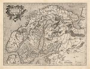
Suecia Et Norvegia cum confinijs.
sold
- Digital Map Information
- Suitable for large format printing
- Full resolution TIFF file
- ICC color profile embedded
- Delivered instantly via download link
This is a superb example of the 1595 first atlas edition of Gerard Mercator's map of Scandinavia. Among the maps of the north parts of Europe produced in the sixteenth century, this is the first to focus narrowly on Scandinavia. Ginsberg, typically laconic in praise, notes that the map 'gave the Scandinavian peninsula its correct form' and 'became the model for nearly all subsequent maps of Scandinavia.' This basic model would stand until supplanted in the mid-seventeenth century by the work of Anders Bure. (more details)
Rare chart from first published nautical atlas.
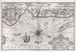
De Custen van een deel van Denemarken en Swederÿck, beginnede va Uuytste tot Calmer Toe…
sold
- Digital Map Information
- Suitable for large format printing
- DPI: 300
- File Size: 9.01 MB
- File Type: ZIP / TIFF
- ICC color profile embedded
- Delivered instantly via download link
This 1586 nautical chart or maritime map of Sweden and Denmark along the North Sea was produced by Lucas Janszoon Waghenaer for his 1586 Spieghel Der Zeevaerdt , a chart book of European coastlines. This nautical chart is oriented to the northeast and covers the ... (more details)
Rare chart from first published nautical atlas.
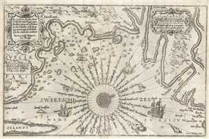
Zee Custe van Sweeden, otrent de Westernÿck en tgatt vann Stockholm, beginnende va Kalmar tot den Wigsteen en Rookoe gelegen bynnenn tgatt va Stockholm alfoe hem tlandt daer verthoont
sold
- Digital Map Information
- Suitable for large format printing
- Full resolution TIFF file
- ICC color profile embedded
- Delivered instantly via download link
This 1583 nautical chart or maritime map of Sweden along the Swedish Sea was produced by Lucas Janszoon Waghenaer. This chart is oriented to the west-northwest and depicts the coastline from Kalmar and Öland (Oelandt) in the southwest to the route to Stockholm ... (more details)
One of the earliest obtainable specific maps of Greenland.
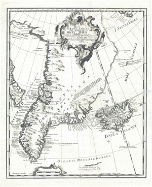
Nova Gronlandiae Islandiae et Freti Davis tabula : quam ex recentissimis, usque selectissimis peritiorum Navarchorum, item Dannicae missionis observationibus, relationibus atque diariis, peculiari studio.
sold
- Digital Map Information
- Suitable for large format printing
- DPI: 300
- File Size: 4.25 MB
- File Type: ZIP / TIFF
- ICC color profile embedded
- Delivered instantly via download link
A scarce 1746 map of Greenland drawn to illustrated Johann Anderson's study on the North Atlantic, Nachrichten von Island, Grønland und der Strasse Davis . This is one of the earliest specific maps of Greenland. It covers from the Baffin Sea and Spitsbergen ... (more details)
Earliest Acquirable Map of Denmark based on a Danish Source.
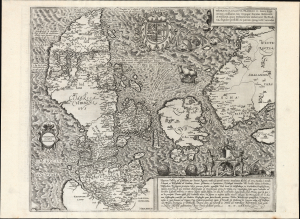
Danorum Marca, vel Cimbricum, aut Daniae Regnum...
sold
- Digital Map Information
- Suitable for large format printing
- Full resolution TIFF file
- ICC color profile embedded
- Delivered instantly via download link
This is a superb example of Marcus Jordan's map of Denmark. Printed in 1588 by Georg Braun and Franz Hogenberg, it is the only map to be included in their eight-volume city atlas (as distinct from the work's abundant city plans and views). It is the first full-sheet printed map of Denmark, and is the earliest surviving printed map of Denmark produced from Danish sources. For collectors of Denmark, it is an essential and scarce work. (more details)
Earliest acquirable state of the Zeno map.
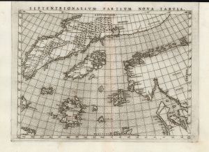
Septentrionalium Partium Nova Tabula.
sold
- Digital Map Information
- Suitable for large format printing
- Full resolution TIFF file
- ICC color profile embedded
- Delivered instantly via download link
This is the most important map of Girolamo Ruscelli's 1561 - 1562 edition Ptolemy: the earliest acquirable iteration of Nicoló Zeno's 1558 Carta Da Navegar De Nicolo et Antonio Zeni Furono In Tramontana Lano MCCCLXXX, revealing the alleged 14th-century voyages of Zeno's ancestors, Nicoló and Antonio. Zeno's fraud, intended to enhance his political power in Venice and later embraced as to co-opt the 1492 Columbia discovery of America, was responsible for the initial appearance and subsequent tenacity of the apocryphal islands Frisland, Icaria, Drogeo, and the coastline of Estotiland, which was taken by some of Europe's finest geographers to be the coast of Labrador. (more details)
Extremely rare nautical chart of the Kattegat and Baltic Seas.
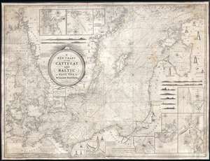
A New Chart of the Cattegat and Baltic or East Sea.
sold
- Digital Map Information
- Suitable for large format printing
- DPI: 300
- File Size: 45.15 MB
- File Type: ZIP / TIFF
- ICC color profile embedded
- Delivered instantly via download link
This is an extremely rare and extraordinarily beautiful 1837 William Heather and John William Norie blueback nautical chart or maritime map of the Kattegat and Baltic Seas. The map depicts the region from Norway and Denmark (Jutland) to the Baltic States of Estonia and Latvia (Eastland, Livonia, Courland) and from Norway and the Gulf of Finland to northern Europe. The map is highly detailed with numerous cities are labeled, including Copenhagen, Stockholm (Christiana), Gdańsk (Danzig), Talinn (Revel), and Riga. Myriad depth soundings are indicated, particularly in the Kattegat Sea and along the coastlines. Numerous inset maps are included along three of the four sides. Along the top border, three inset maps situated and illustrate the entrances to Gothenburg, the principal entrance to Stockholm, and the harbor of Sleete or Slitehamn, on the island of Gottland. Along the right side and bottom border, inset maps depict the entrance to Klaipėda (Memel), Lithuania, Riga, Rogerwyck, the entrance to Szczecin (Stettin), Poland, Baltiysk, Poland, and a second inset map illustrating the entrance to Szczecin. Manuscript notations in yellow ink throughout the map mark the locations of lighthouses and other lights used for navigation. Twenty-eight different lighthouses are illustrated in profile, along with notes concerning others. One such note, located on the Jutland Peninsula, informs the viewer that a striped flag is hoisted from the Scaw lighthouse if ice in the Kattegat impedes navigation. Other notes inform the viewer on improvements to harbors, or when the lighthouses in certain parts of the region are lit. Several coastal views are also illustrated, allowing a mariner to have a better understanding of what they should be seeing when passing a given stretch of coastline. An extremely decorative title cartouche is situated slightly to the left of center. (more details)
Stunning example of the dominant 17th century map of Iceland.
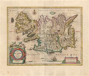
Tabula Islandiae Auctore Georgio Carolo Flandro.
sold
- Digital Map Information
- Suitable for large format printing
- Full resolution TIFF file
- ICC color profile embedded
- Delivered instantly via download link
This is a superb example of Willem and Joan Blaeu's map of Iceland, among the most influential and widely-copied seventeenth century maps of the island. It was engraved in 1628 by Jodocus Hondius the younger, who credited the map to Joris Carolus. Carolus was a noted Dutch navigator and explorer whose extensive travels to Spitzbergen, Davis Strait and other islands of the North Atlantic - and whose own exaggerations of the extent of those travels - established him as an authority on the northern oceans. Carolus' travels did take him to Iceland more than once, but it may be that Hondius used the navigator's name specifically in order to incorporate the navigators' authority without necessarily relying on any information from him. (more details)