This item has been sold, but you can get on the Waitlist to be notified if another example becomes available.
1845 Logerot Jigsaw Puzzle Atlas of the World
Atlas-logerot-1845$1,000.00

Title
Atlas.
c. 1850 (undated) 8 x 11 in (20.32 x 27.94 cm)
c. 1850 (undated) 8 x 11 in (20.32 x 27.94 cm)
Description
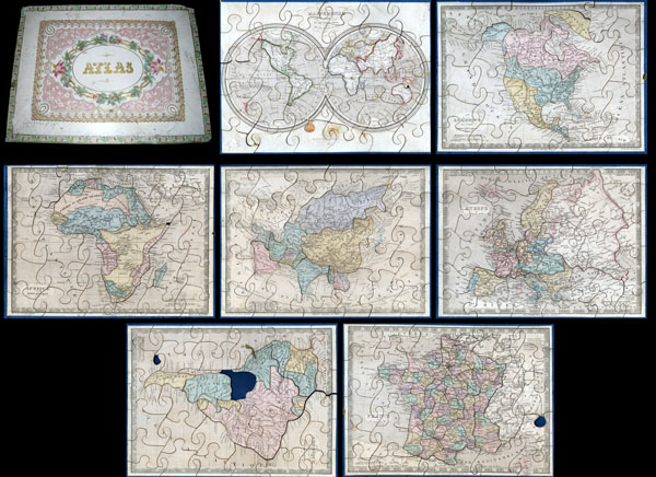
A very attractive an unusual c. 1850 jigsaw puzzle atlas published by Auguste Logerot. Consists a custom box of seven interesting jigsaw puzzle maps: the World, North America, South America, Europe, Asia, Africa and France. Each map is mounted on a board and dissected as a jigsaw puzzle. States and regions are individually dissected along their boundaries while oceans are dissected into more traditional jigsaw puzzle patterns. Individually the maps are based upon Dyonnet's engravings for A. R. Fremin's geography.
The North American map is probably the most interesting showing Mexico's claims to much of what is today the American Southwest, including the modern day states of California, Arizona, New Mexico, Nevada, Colorado and Utah. Texas is colored as part of the United States but looking closely one can see that it is clearly drawn as a separate independent nation. Also shows the U.S. claims to British Columbia, to the latitude of 54°40,' prior to the Oregon Treat.
The Africa map exhibits the somewhat limited knowledge of Africa's interior in the early 19th century. Coastal areas are well mapped by the interior is somewhat vague. Various tribes are noted but none of the Rift Valley lakes appear. Missing a small piece on the Horn.
The world map is a beautifully drawn hemispherical projection. Labels Australia as New Holland. Missing a tiny chunk near New Guinea.
The map of France is divided according to departments. Missing small chunk in the lower right quadrant.
South America map is missing the Bolivia piece and a small chunk in the lower left quadrant.
Puzzle maps like this were first made in London by John Spilsbury in the 1760s. The style passed to the continent and became a popular educational tool in France and Germany in the early to mid 19th century. While rare and often in poor condition, these curious maps and atlases are among the most amusing and whimsical geographic themed educational devices to appear in the 19th century.
CartographerS
Auguste Logerot (fl. c. 1839 - c. 1880) was a French map and general interest publisher active throughout the mid to late 19th century. A. Logerot worked with other French publishers, cartographers and engravers of the period including Fremin, Dufour, Dyonnet, and Vuillemin. He published a large corpus of map and geographical atlases, though few of his map represented unique or exceptionally interesting work. This exception are his wonderful jigsaw puzzle maps - a style popular in 19th century France. Jigsaw puzzle maps are a kind of educational map printed on board and carved up in puzzle format. Logerot's imprint is frequently misprinted as Lagerot or Logeret. Logerot shared offices with several other publishers, printers and engravers at Quai des Augustins 55, Paris. Little else is known of Logerot's life and work. More by this mapmaker...
A. R. Fremin (fl. c. 1810 - c. 1860) was a French geographer active in the early to mid 19th century. He is known to have been a student of the cartographer Jean-Baptiste Poirson. Fremin drew and compiled maps for many prominent French cartographic publishers of the period including Tardieu, Logerot, Dufour, Monin, Duvotenay, Dyonnet, and Vuillemin. Little else is known of Fremin's life and work. Learn More...
Charles Dyonnet (fl. c. 1822 - c. 1880) was an extremely active Paris based engraver working in the mid to late 19th century. From his offices at 220 Rue St. Jacques, Paris, Dyonnet engraved numerous maps for many of the most prominent 19th French cartographic publishers including Vuillemin, Dufour, Fremin and Duvotenay. From 1850-1861, he held the coveted position of "Graveur du Dépot de la Marine," and in this position engraved numerous French naval and military maps. Dyonnet had a detail oriented and aesthetically minded hand and is responsible from some of the most beautiful French maps to emerge during the 19th century. Learn More...
Source
Logerot, A., Atlas, c. 1850.
Condition
Generally very good condition. Wear and damage to box, especially at edges. Maps in very good conditon and generally complete. Minor damage to two fo thepieces int the world map. South America map missing the 'Bolivia' piece. See photos.
References
Rumsey 4782.001 (Similar Example).