This item has been sold, but you can get on the Waitlist to be notified if another example becomes available.
1900 Poole Brothers Railroad Prospectus Atlas of the United States
RailroadProspectus-poole-1900$250.00

Title
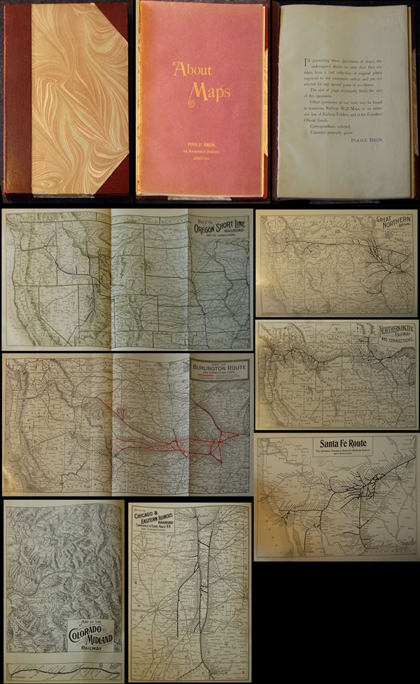
About Maps.
1900 (undated) 11 x 9 in (27.94 x 22.86 cm)
1900 (undated) 11 x 9 in (27.94 x 22.86 cm)
Description
This is a beautiful railroad prospectus atlas issued by the Poole Brothers published around 1900. Designed to advertise the Poole Brothers' diversity in map making and their comprehensive knowledge of railroads, the prospectus atlas contains reduced versions of some of the most important maps issued by the Poole Bothers. Covering the entire United States, as well as part of Canada and the West Indies, the prospectus includes:
1. Map of the Lehigh ValleyAdditional smaller maps are also included. Offers superb detail of the American railway network. This atlas was issued by the Poole Brothers around 1900 and contains a prospectus of work to enable sale. Overall a comprehensive look at the railroads in America.
2. Map of Burlington Route and connecting lines
3. Northern Pacific Railway and connections
4. Great Northern Railway
5. Map of the Houston and Texas Central Railroad
6. The Pennsylvania Lines
7. Map of the Oregon Short Line Railroad
8. Map of the Grand Rapids and Indiana Railway
9. Southern Railway
10. Map of Denver and Rio Grande Scenic Line of the World
11. Map of the Louisville and Nashville Railroad
12. Grand Trunk Railway System
13. Canadian Pacific Railway
14. The North-Western Line
15. Map of St. Louis and San Francisco Railroad
16. Santa Fe Route
17. Map of the Texas and Pacific Railway
18. The Rio Grande Western Railway Great Salt Lake Route
19. Map of the Baltimore and Ohio Railroad
20. Map of the Lake Shore and Michigan Southern Railway
21. Southern Pacific Company Sunset Ogden and Shasta Routes
22. Map of the Colorado Midland Railway
23. Map of Oregon Railroad and Navigation Company
24. The Wabash Line
25. Map of Chicago and Eastern Illinois Railroad
26. Map of Estes Park
27. Canadian Pacific Routes Around the World
Cartographer
Poole Brothers (1878 - 1968) were a Chicago based firm active in the late 19th and early 20th century with an initial focus on promotional railroad maps. Poole Brothers was founded by George Amos Poole (March 20, 1843 – September 7, 1918). In 1868, Poole, along with his uncle William H. Rand (1828 - 1915) and Andrew McNally (1836 - 1904), purchased the Chicago Tribune's job printing plant and formed the firm Rand McNally. In 1878, he left Rand McNally to form, with his brother William H. Poole, Poole Brothers, a direct competitor to Rand McNally for the lucrative railroad business. Like many of its competitors, Poole Brothers maintained an office on Chicago's Printer's Row (downtown Loop district). Their earliest known work is an 1880 map of Yellowstone National Park. In 1887, Poole Brothers, Andrew McNally, and several others formed the United Typothetae of America, a master printers association. In 1848, they were cited, along with Rand McNally and George Cram, by the Federal Trade Commission for price fixing. Their earliest known work is an 1880 map of Yellowstone National Park. Afterward they went on to produce a vast range of maps and other print products including tickets, cards, coupons, and restaurant menus. In time Poole Brothers merged with Newman-Randolph, which was then acquired by the American Can Company in the early 1960s. The American Can Company liquidated its printing concerns later in the same decade. More by this mapmaker...
Condition
Very good. Contains over 30 maps.